- Canton Champion Fibre Company (2308)
- Cherokee Traditions (291)
- Civil War in Southern Appalachia (165)
- Craft Revival (1942)
- Great Smoky Mountains - A Park for America (2857)
- Highlights from Western Carolina University (430)
- Horace Kephart (941)
- Journeys Through Jackson (159)
- LGBTQIA+ Archive of Jackson County (85)
- Oral Histories of Western North Carolina (314)
- Picturing Appalachia (6772)
- Stories of Mountain Folk (413)
- Travel Western North Carolina (160)
- Western Carolina University Fine Art Museum Vitreograph Collection (129)
- Western Carolina University Herbarium (92)
- Western Carolina University: Making Memories (708)
- Western Carolina University Publications (2353)
- Western Carolina University Restricted Electronic Theses and Dissertations (146)
- Western North Carolina Regional Maps (71)
- World War II in Southern Appalachia (131)
- Allanstand Cottage Industries (62)
- Appalachian National Park Association (53)
- Bennett, Kelly, 1890-1974 (1388)
- Berry, Walter (76)
- Brasstown Carvers (40)
- Carver, George Washington, 1864?-1943 (26)
- Cathey, Joseph, 1803-1874 (1)
- Champion Fibre Company (233)
- Champion Paper and Fibre Company (297)
- Cherokee Indian Fair Association (16)
- Cherokee Language Program (22)
- Crowe, Amanda (40)
- Edmonston, Thomas Benton, 1842-1907 (7)
- Ensley, A. L. (Abraham Lincoln), 1865-1948 (275)
- Fromer, Irving Rhodes, 1913-1994 (70)
- George Butz (BFS 1907) (46)
- Goodrich, Frances Louisa (120)
- Grant, George Alexander, 1891-1964 (96)
- Heard, Marian Gladys (60)
- Kephart, Calvin, 1883-1969 (15)
- Kephart, Horace, 1862-1931 (313)
- Kephart, Laura, 1862-1954 (39)
- Laney, Gideon Thomas, 1889-1976 (439)
- Masa, George, 1881-1933 (61)
- McElhinney, William Julian, 1896-1953 (44)
- Niggli, Josephina, 1910-1983 (10)
- North Carolina Park Commission (105)
- Osborne, Kezia Stradley (9)
- Owens, Samuel Robert, 1918-1995 (11)
- Penland Weavers and Potters (36)
- Roberts, Vivienne (15)
- Roth, Albert, 1890-1974 (142)
- Schenck, Carl Alwin, 1868-1955 (1)
- Sherrill's Photography Studio (2565)
- Southern Highland Handicraft Guild (127)
- Southern Highlanders, Inc. (71)
- Stalcup, Jesse Bryson (46)
- Stearns, I. K. (213)
- Thompson, James Edward, 1880-1976 (226)
- United States. Indian Arts and Crafts Board (130)
- USFS (683)
- Vance, Zebulon Baird, 1830-1894 (1)
- Weaver, Zebulon, 1872-1948 (58)
- Western Carolina College (230)
- Western Carolina Teachers College (282)
- Western Carolina University (1840)
- Western Carolina University. Mountain Heritage Center (18)
- Whitman, Walt, 1819-1892 (10)
- Wilburn, Hiram Coleman, 1880-1967 (73)
- Williams, Isadora (3)
- Cain, Doreyl Ammons (0)
- Crittenden, Lorraine (0)
- Rhodes, Judy (0)
- Smith, Edward Clark (0)
- Appalachian Region, Southern (2569)
- Asheville (N.C.) (1923)
- Avery County (N.C.) (26)
- Blount County (Tenn.) (169)
- Buncombe County (N.C.) (1672)
- Cherokee County (N.C.) (283)
- Clay County (N.C.) (555)
- Graham County (N.C.) (233)
- Great Smoky Mountains National Park (N.C. and Tenn.) (519)
- Haywood County (N.C.) (3567)
- Henderson County (N.C.) (70)
- Jackson County (N.C.) (4745)
- Knox County (Tenn.) (31)
- Knoxville (Tenn.) (12)
- Lake Santeetlah (N.C.) (10)
- Macon County (N.C.) (420)
- Madison County (N.C.) (215)
- McDowell County (N.C.) (39)
- Mitchell County (N.C.) (132)
- Polk County (N.C.) (35)
- Qualla Boundary (981)
- Rutherford County (N.C.) (76)
- Swain County (N.C.) (2117)
- Transylvania County (N.C.) (270)
- Watauga County (N.C.) (12)
- Waynesville (N.C.) (84)
- Yancey County (N.C.) (72)
- Aerial Photographs (3)
- Aerial Views (60)
- Albums (books) (4)
- Articles (1)
- Artifacts (object Genre) (228)
- Bibliographies (1)
- Biography (general Genre) (2)
- Cards (information Artifacts) (38)
- Clippings (information Artifacts) (191)
- Copybooks (instructional Materials) (3)
- Crafts (art Genres) (622)
- Depictions (visual Works) (21)
- Design Drawings (1)
- Drawings (visual Works) (185)
- Envelopes (73)
- Exhibitions (events) (1)
- Facsimiles (reproductions) (1)
- Fiction (general Genre) (4)
- Financial Records (12)
- Fliers (printed Matter) (67)
- Glass Plate Negatives (381)
- Guidebooks (2)
- Internegatives (10)
- Interviews (815)
- Land Surveys (102)
- Letters (correspondence) (1013)
- Manuscripts (documents) (618)
- Maps (documents) (177)
- Memorandums (25)
- Minutes (administrative Records) (59)
- Negatives (photographs) (5926)
- Newsletters (1290)
- Newspapers (2)
- Notebooks (8)
- Occupation Currency (1)
- Paintings (visual Works) (1)
- Pen And Ink Drawings (1)
- Periodicals (193)
- Personal Narratives (10)
- Photographs (12976)
- Plans (maps) (1)
- Poetry (5)
- Portraits (4535)
- Postcards (329)
- Programs (documents) (151)
- Publications (documents) (2305)
- Questionnaires (65)
- Sayings (literary Genre) (1)
- Scrapbooks (282)
- Sheet Music (2)
- Slides (photographs) (402)
- Songs (musical Compositions) (2)
- Sound Recordings (796)
- Specimens (92)
- Speeches (documents) (15)
- Tintypes (photographs) (8)
- Transcripts (322)
- Video Recordings (physical Artifacts) (23)
- Vitreographs (129)
- Text Messages (0)
- A.L. Ensley Collection (275)
- Appalachian Industrial School Records (7)
- Appalachian National Park Association Records (336)
- Axley-Meroney Collection (2)
- Bayard Wootten Photograph Collection (20)
- Bethel Rural Community Organization Collection (7)
- Blumer Collection (5)
- C.W. Slagle Collection (20)
- Canton Area Historical Museum (2110)
- Carlos C. Campbell Collection (373)
- Cataloochee History Project (64)
- Cherokee Studies Collection (4)
- Daisy Dame Photograph Album (5)
- Daniel Boone VI Collection (1)
- Doris Ulmann Photograph Collection (112)
- Elizabeth H. Lasley Collection (1)
- Elizabeth Woolworth Szold Fleharty Collection (4)
- Frank Fry Collection (95)
- George Masa Collection (173)
- Gideon Laney Collection (452)
- Hazel Scarborough Collection (2)
- Hiram C. Wilburn Papers (28)
- Historic Photographs Collection (236)
- Horace Kephart Collection (861)
- Humbard Collection (33)
- Hunter and Weaver Families Collection (1)
- I. D. Blumenthal Collection (4)
- Isadora Williams Collection (4)
- Jesse Bryson Stalcup Collection (47)
- Jim Thompson Collection (224)
- John B. Battle Collection (7)
- John C. Campbell Folk School Records (80)
- John Parris Collection (6)
- Judaculla Rock project (2)
- Kelly Bennett Collection (1407)
- Love Family Papers (11)
- Major Wiley Parris Civil War Letters (3)
- Map Collection (12)
- McFee-Misemer Civil War Letters (34)
- Mountain Heritage Center Collection (4)
- Norburn - Robertson - Thomson Families Collection (44)
- Pauline Hood Collection (7)
- Pre-Guild Collection (2)
- Qualla Arts and Crafts Mutual Collection (12)
- R.A. Romanes Collection (681)
- Rosser H. Taylor Collection (1)
- Samuel Robert Owens Collection (94)
- Sara Madison Collection (144)
- Sherrill Studio Photo Collection (2558)
- Smoky Mountains Hiking Club Collection (616)
- Stories of Mountain Folk - Radio Programs (374)
- The Reporter, Western Carolina University (510)
- Venoy and Elizabeth Reed Collection (16)
- WCU Gender and Sexuality Oral History Project (32)
- WCU Mountain Heritage Center Oral Histories (25)
- WCU Oral History Collection - Mountain People, Mountain Lives (71)
- WCU Students Newspapers Collection (1784)
- Western North Carolina Tomorrow Black Oral History Project (69)
- William Williams Stringfield Collection (2)
- Zebulon Weaver Collection (109)
- African Americans (390)
- Appalachian Trail (35)
- Artisans (521)
- Cherokee art (84)
- Cherokee artists -- North Carolina (10)
- Cherokee language (21)
- Cherokee pottery (101)
- Cherokee women (208)
- Church buildings (170)
- Civilian Conservation Corps (U.S.) (110)
- College student newspapers and periodicals (1876)
- Dams (107)
- Dance (1023)
- Education (222)
- Floods (61)
- Folk music (1015)
- Forced removal, 1813-1903 (2)
- Forest conservation (220)
- Forests and forestry (1184)
- Gender nonconformity (4)
- Great Smoky Mountains National Park (N.C. and Tenn.) (181)
- Hunting (45)
- Landscape photography (25)
- Logging (118)
- Maps (83)
- Mines and mineral resources (8)
- North Carolina -- Maps (18)
- Paper industry (38)
- Postcards (255)
- Pottery (135)
- Railroad trains (71)
- Rural electrification -- North Carolina, Western (3)
- School integration -- Southern States (2)
- Segregation -- North Carolina, Western (5)
- Slavery (5)
- Sports (452)
- Storytelling (243)
- Waterfalls -- Great Smoky Mountains (N.C. and Tenn.) (66)
- Weaving -- Appalachian Region, Southern (280)
- Wood-carving -- Appalachian Region, Southern (328)
- World War, 1939-1945 (173)
Guide to the Great Smoky Mountains National Park

Guide to the Great Smoky Mountains National Park
HL_F443_G7_M15_001
Guide to the Great Smoky Mountains National Park
HL_F443_G7_M15_002
Guide to the Great Smoky Mountains National Park
HL_F443_G7_M15_003
Guide to the Great Smoky Mountains National Park
HL_F443_G7_M15_004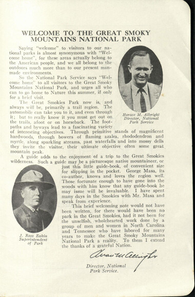
Guide to the Great Smoky Mountains National Park
HL_F443_G7_M15_005
Guide to the Great Smoky Mountains National Park
HL_F443_G7_M15_006
Guide to the Great Smoky Mountains National Park
HL_F443_G7_M15_007
Guide to the Great Smoky Mountains National Park
HL_F443_G7_M15_008
Guide to the Great Smoky Mountains National Park
HL_F443_G7_M15_009
Guide to the Great Smoky Mountains National Park
HL_F443_G7_M15_010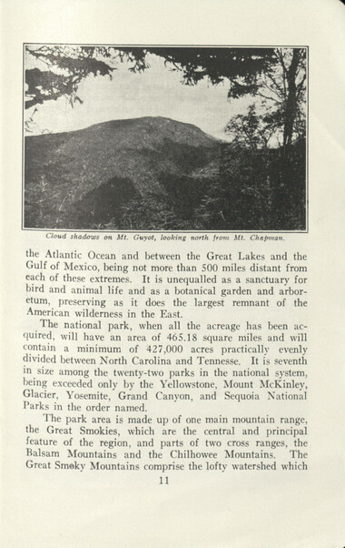
Guide to the Great Smoky Mountains National Park
HL_F443_G7_M15_011
Guide to the Great Smoky Mountains National Park
HL_F443_G7_M15_012
Guide to the Great Smoky Mountains National Park
HL_F443_G7_M15_013
Guide to the Great Smoky Mountains National Park
HL_F443_G7_M15_014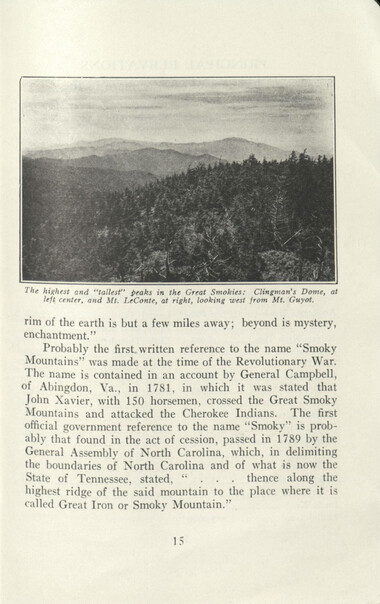
Guide to the Great Smoky Mountains National Park
HL_F443_G7_M15_015
Guide to the Great Smoky Mountains National Park
HL_F443_G7_M15_016
Guide to the Great Smoky Mountains National Park
HL_F443_G7_M15_017
Guide to the Great Smoky Mountains National Park
HL_F443_G7_M15_018
Guide to the Great Smoky Mountains National Park
HL_F443_G7_M15_019
Guide to the Great Smoky Mountains National Park
HL_F443_G7_M15_020
Guide to the Great Smoky Mountains National Park
HL_F443_G7_M15_021
Guide to the Great Smoky Mountains National Park
HL_F443_G7_M15_022
Guide to the Great Smoky Mountains National Park
HL_F443_G7_M15_023
Guide to the Great Smoky Mountains National Park
HL_F443_G7_M15_024
Guide to the Great Smoky Mountains National Park
HL_F443_G7_M15_025
Guide to the Great Smoky Mountains National Park
HL_F443_G7_M15_026
Guide to the Great Smoky Mountains National Park
HL_F443_G7_M15_027
Guide to the Great Smoky Mountains National Park
HL_F443_G7_M15_028
Guide to the Great Smoky Mountains National Park
HL_F443_G7_M15_029
Guide to the Great Smoky Mountains National Park
HL_F443_G7_M15_030
Guide to the Great Smoky Mountains National Park
HL_F443_G7_M15_031
Guide to the Great Smoky Mountains National Park
HL_F443_G7_M15_032
Guide to the Great Smoky Mountains National Park
HL_F443_G7_M15_033
Guide to the Great Smoky Mountains National Park
HL_F443_G7_M15_034
Guide to the Great Smoky Mountains National Park
HL_F443_G7_M15_035
Guide to the Great Smoky Mountains National Park
HL_F443_G7_M15_036
Guide to the Great Smoky Mountains National Park
HL_F443_G7_M15_037
Guide to the Great Smoky Mountains National Park
HL_F443_G7_M15_038
Guide to the Great Smoky Mountains National Park
HL_F443_G7_M15_039
Guide to the Great Smoky Mountains National Park
HL_F443_G7_M15_040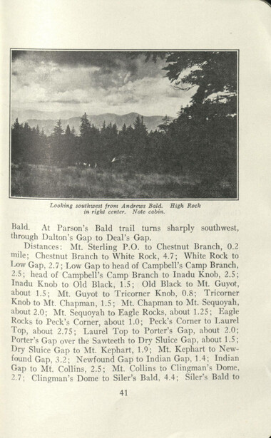
Guide to the Great Smoky Mountains National Park
HL_F443_G7_M15_041
Guide to the Great Smoky Mountains National Park
HL_F443_G7_M15_042
Guide to the Great Smoky Mountains National Park
HL_F443_G7_M15_043
Guide to the Great Smoky Mountains National Park
HL_F443_G7_M15_044
Guide to the Great Smoky Mountains National Park
HL_F443_G7_M15_045
Guide to the Great Smoky Mountains National Park
HL_F443_G7_M15_046
Guide to the Great Smoky Mountains National Park
HL_F443_G7_M15_047
Guide to the Great Smoky Mountains National Park
HL_F443_G7_M15_048
Guide to the Great Smoky Mountains National Park
HL_F443_G7_M15_049
Guide to the Great Smoky Mountains National Park
HL_F443_G7_M15_050
Guide to the Great Smoky Mountains National Park
HL_F443_G7_M15_051
Guide to the Great Smoky Mountains National Park
HL_F443_G7_M15_052
Guide to the Great Smoky Mountains National Park
HL_F443_G7_M15_053
Guide to the Great Smoky Mountains National Park
HL_F443_G7_M15_054
Guide to the Great Smoky Mountains National Park
HL_F443_G7_M15_055
Guide to the Great Smoky Mountains National Park
HL_F443_G7_M15_056
Guide to the Great Smoky Mountains National Park
HL_F443_G7_M15_057
Guide to the Great Smoky Mountains National Park
HL_F443_G7_M15_058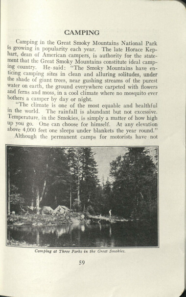
Guide to the Great Smoky Mountains National Park
HL_F443_G7_M15_059
Guide to the Great Smoky Mountains National Park
HL_F443_G7_M15_060
Guide to the Great Smoky Mountains National Park
HL_F443_G7_M15_061
Guide to the Great Smoky Mountains National Park
HL_F443_G7_M15_062
Guide to the Great Smoky Mountains National Park
HL_F443_G7_M15_063
Guide to the Great Smoky Mountains National Park
HL_F443_G7_M15_064
Guide to the Great Smoky Mountains National Park
HL_F443_G7_M15_065
Guide to the Great Smoky Mountains National Park
HL_F443_G7_M15_066
Guide to the Great Smoky Mountains National Park
HL_F443_G7_M15_067
Guide to the Great Smoky Mountains National Park
HL_F443_G7_M15_068
Guide to the Great Smoky Mountains National Park
HL_F443_G7_M15_069
Guide to the Great Smoky Mountains National Park
HL_F443_G7_M15_070
Guide to the Great Smoky Mountains National Park
HL_F443_G7_M15_071
Guide to the Great Smoky Mountains National Park
HL_F443_G7_M15_072
Guide to the Great Smoky Mountains National Park
HL_F443_G7_M15_073
Guide to the Great Smoky Mountains National Park
HL_F443_G7_M15_074
Guide to the Great Smoky Mountains National Park
HL_F443_G7_M15_075
Guide to the Great Smoky Mountains National Park
HL_F443_G7_M15_076
Guide to the Great Smoky Mountains National Park
HL_F443_G7_M15_077
Guide to the Great Smoky Mountains National Park
HL_F443_G7_M15_078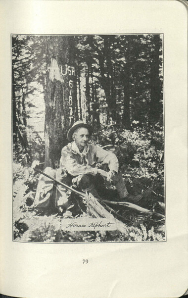
Guide to the Great Smoky Mountains National Park
HL_F443_G7_M15_079
Guide to the Great Smoky Mountains National Park
HL_F443_G7_M15_080
Guide to the Great Smoky Mountains National Park
HL_F443_G7_M15_081
Guide to the Great Smoky Mountains National Park
HL_F443_G7_M15_082
Guide to the Great Smoky Mountains National Park
HL_F443_G7_M15_083
Guide to the Great Smoky Mountains National Park
HL_F443_G7_M15_084
Guide to the Great Smoky Mountains National Park
HL_F443_G7_M15_085
Guide to the Great Smoky Mountains National Park
HL_F443_G7_M15_086
Guide to the Great Smoky Mountains National Park
HL_F443_G7_M15_087
Guide to the Great Smoky Mountains National Park
HL_F443_G7_M15_088
Guide to the Great Smoky Mountains National Park
HL_F443_G7_M15_089
Guide to the Great Smoky Mountains National Park
HL_F443_G7_M15_090
Guide to the Great Smoky Mountains National Park
HL_F443_G7_M15_091
Guide to the Great Smoky Mountains National Park
HL_F443_G7_M15_092
Guide to the Great Smoky Mountains National Park
HL_F443_G7_M15_093
Guide to the Great Smoky Mountains National Park
HL_F443_G7_M15_094
Guide to the Great Smoky Mountains National Park
HL_F443_G7_M15_095
Guide to the Great Smoky Mountains National Park
HL_F443_G7_M15_096
Guide to the Great Smoky Mountains National Park
HL_F443_G7_M15_097
Guide to the Great Smoky Mountains National Park
HL_F443_G7_M15_098
Guide to the Great Smoky Mountains National Park
HL_F443_G7_M15_099
Guide to the Great Smoky Mountains National Park
HL_F443_G7_M15_100
Guide to the Great Smoky Mountains National Park
HL_F443_G7_M15_101
Guide to the Great Smoky Mountains National Park
HL_F443_G7_M15_102
Guide to the Great Smoky Mountains National Park
HL_F443_G7_M15_103
Guide to the Great Smoky Mountains National Park
HL_F443_G7_M15_104
Guide to the Great Smoky Mountains National Park
HL_F443_G7_M15_105
Guide to the Great Smoky Mountains National Park
HL_F443_G7_M15_106
Guide to the Great Smoky Mountains National Park
HL_F443_G7_M15_107
Guide to the Great Smoky Mountains National Park
HL_F443_G7_M15_108
Guide to the Great Smoky Mountains National Park
HL_F443_G7_M15_109
Guide to the Great Smoky Mountains National Park
HL_F443_G7_M15_110
Guide to the Great Smoky Mountains National Park
HL_F443_G7_M15_111
Guide to the Great Smoky Mountains National Park
HL_F443_G7_M15_112
Guide to the Great Smoky Mountains National Park
HL_F443_G7_M15_113
Guide to the Great Smoky Mountains National Park
HL_F443_G7_M15_114
Guide to the Great Smoky Mountains National Park
HL_F443_G7_M15_115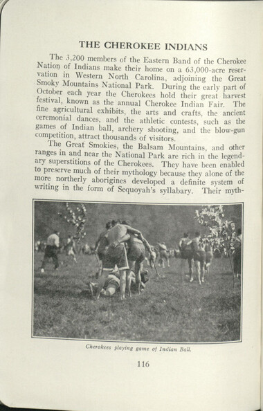
Guide to the Great Smoky Mountains National Park
HL_F443_G7_M15_116
Guide to the Great Smoky Mountains National Park
HL_F443_G7_M15_117
Guide to the Great Smoky Mountains National Park
HL_F443_G7_M15_118
Guide to the Great Smoky Mountains National Park
HL_F443_G7_M15_119
Guide to the Great Smoky Mountains National Park
HL_F443_G7_M15_120
Guide to the Great Smoky Mountains National Park
HL_F443_G7_M15_121
Guide to the Great Smoky Mountains National Park
HL_F443_G7_M15_122
Guide to the Great Smoky Mountains National Park
HL_F443_G7_M15_123
Guide to the Great Smoky Mountains National Park
HL_F443_G7_M15_124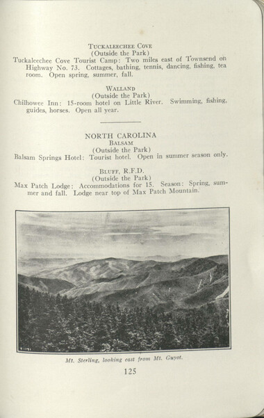
Guide to the Great Smoky Mountains National Park
HL_F443_G7_M15_125
Guide to the Great Smoky Mountains National Park
HL_F443_G7_M15_126
Guide to the Great Smoky Mountains National Park
HL_F443_G7_M15_127
Guide to the Great Smoky Mountains National Park
HL_F443_G7_M15_128
Guide to the Great Smoky Mountains National Park
HL_F443_G7_M15_129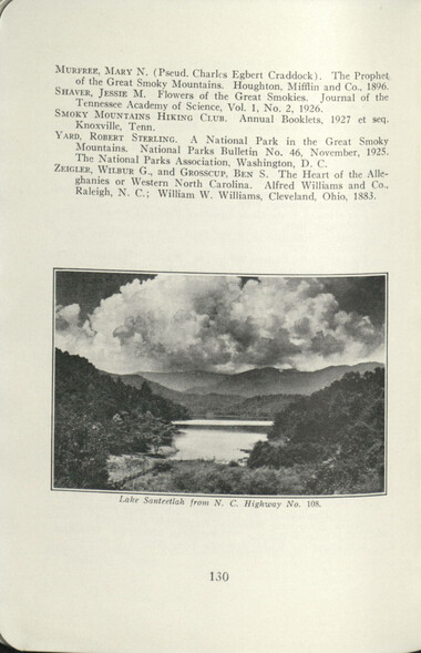
Guide to the Great Smoky Mountains National Park
HL_F443_G7_M15_130
Guide to the Great Smoky Mountains National Park
HL_F443_G7_M15_131
Guide to the Great Smoky Mountains National Park
HL_F443_G7_M15_132
Guide to the Great Smoky Mountains National Park
HL_F443_G7_M15_133
Guide to the Great Smoky Mountains National Park
HL_F443_G7_M15_134
Guide to the Great Smoky Mountains National Park
HL_F443_G7_M15_135
Guide to the Great Smoky Mountains National Park
HL_F443_G7_M15_136
Guide to the Great Smoky Mountains National Park
HL_F443_G7_M15_137
Guide to the Great Smoky Mountains National Park
HL_F443_G7_M15_138
Guide to the Great Smoky Mountains National Park
HL_F443_G7_M15_139
Guide to the Great Smoky Mountains National Park
HL_F443_G7_M15_140
Guide to the Great Smoky Mountains National Park
HL_F443_G7_M15_141
Guide to the Great Smoky Mountains National Park
HL_F443_G7_M15_143
Guide to the Great Smoky Mountains National Park
HL_F443_G7_M15_144
Guide to the Great Smoky Mountains National Park
HL_F443_G7_M15_145Item’s are ‘child’ level descriptions to ‘parent’ objects, (e.g. one page of a whole book).
-
-
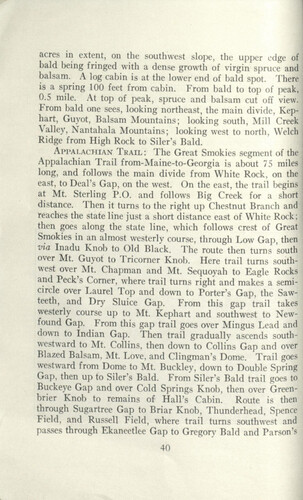
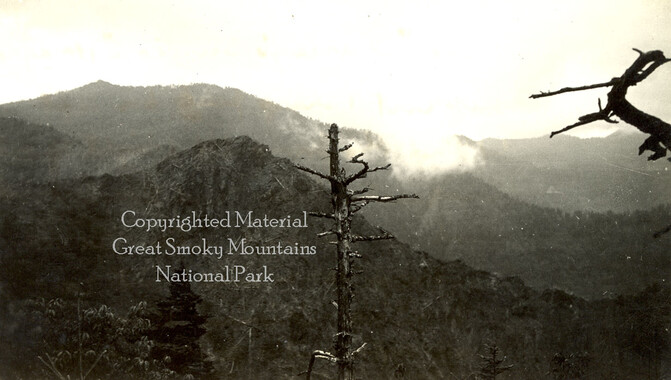
acres in extent, on the southwest slope, the upper edge of bald being fringed with a dense growth of virgin spruce and balsam. A log cabin is at the lower end of bald spot. There is a spring 100 feet from cabin. From bald to top of peak, 0.5 mile. At top of peak, spruce and balsam cut off view. From bald one sees, looking northeast, the main divide, Kephart, Guyot, Balsam Mountains; looking south, Mill Creek Valley, Nantahala Mountains; looking west to north, Welch Ridge' from High Rock to Siler's Bald. Appalachian Trail: The Great Smokies segment of the Appalachian Trail from-Maine-to-Georgia is about 75 miles long, and follows the main divide from White Rock, on the : east, to Deal's Gap, on the west. On the east, the trail begins ; at Mt. Sterling P.O. and follows Big Creek for a short distance. Then it turns to the right up Chestnut Branch and teaches the state line just a short distance east of White Rock; then goes along the state line, which follows crest of Great Smokies in an almost westerly course, through Low Gap, then via Inadu Knob to Old Black. The route then turns south over Mt. Guyot to Tricorner Knob. Here trail turns southwest over Mt. Chapman and Mt. Sequoyah to Eagle Rocks and Peck's Corner, where trail turns right and makes a semicircle over Laurel Top and down to Porter's Gap, the Sawteeth, and Dry Sluice Gap. From this gap trail takes westerly course up to Mt. Kephart and southwest to Newfound Gap. From this gap trail goes over Mingus Lead and down to Indian Gap. Then trail gradually ascends south- westward to Mt. Collins, then down to Collins Gap and over Blazed Balsam, Mt. Love, and Clingman's Dome. Trail goes westward from Dome to Mt. Buckley, down to Double Spring Gap, then up to Siler's Bald. From Siler's Bald trail goes to Buckeye Gap and over Cold Springs Knob, then over Greenbrier Knob to remains of Hall's Cabin. Route is then through Sugartree Gap to Briar Knob, Thunderhead, Spence Field, and Russell Field, where trail turns southwest and passes through Ekaneetlee Gap to Gregory Bald and Parson's 40
Object’s are ‘parent’ level descriptions to ‘children’ items, (e.g. a book with pages).
-
This 146-page “Guide to the Great Smoky Mountains National Park” was published in 1933, a year before the park was formally established. In spite of this oddity, the guide does carry the approval of the National Park Service, stated on its cover. The book was printed in a small format as a field guide that could be carried on a hike. Topics covered in the guide include tours and trails, notes on camping and fishing, and sections on flowers and fauna. Separate sections deal with local culture, including “The Highlanders” and “The Cherokee Indians.” The guide was written by George McCoy and George Masa. McCoy was a staff writer for the Asheville Citizen and native of Dillsboro, North Carolina. Photographer George Masa, a native of Japan, was active in the Appalachian Trail Club and in the movement to establish the Great Smoky Mountains National Park.
-
Related items
-
Western Carolinian Volume 39 Number 06

-
Western Carolinian Volume 59 Number 25 (24)

-
Western Carolinian Volume 58 Number 18

-
Western Carolinian Volume 34 Number 48

-
Western Carolinian Volume 53 Number 15

-
Western Carolinian Volume 50 Number 14

-
Western Carolinian Volume 52 Number 14

-
Western Carolinian Volume 49 Number 10

-
Western Carolinian Volume 38 Number 41
-
Western Carolinian Volume 35 Number 48

-
Western Carolinian Volume 49 Number 26

-
Documentary of Six Cherokee Artists

-
Western Carolinian Volume 46 Number 06, September 25, 1980
-
Sixteenth Annual Session of the Penland School of Handicrafts 1945, catalog, p. 5

-
Western Carolinian Volume 36 Number 15

-
Western Carolinian 1992 Special Edition Homecoming Issue

-
Western Carolinian Volume 64 (65) Number 19 (20)
-
Western Carolinian Volume 50 (49) Number 07

-
Western Carolinian January 19, 1942

-
Western Carolinian Volume 44 Number 32

-
Western Carolinian Volume 07 50th Anniversary
-
Western Carolinia Volume 46 Number 36

-
Shin Seiki: Bagong Araw. New Era

-
Lloyd C. Owle: Sculpture and Carving

-
Western Carolinian Volume 17 (18) Number 03 (03 and 04)
-
Western Carolinian Volume 40 Number 52

-
Western Carolinian Volume 70 Number 08

-
Vegetable Dying

-
Western Carolinian Volume 20 Number 01

-
Western Carolinian Volume 50 Number 10

-
Western Carolinian Volume 67 Number 05

-
Nomenclature Decisions of the United States Geographic Board
Part of Collection
Great Smoky Mountains - A Park for America
-
Floreen or the Story of Mitchell

-
Charlies Bunion, Mount Kephart, and Jump Off
-
Floreen or the Story of Mitchell

-
Hardwood Bark, 1922

-
Trees of the Great Smoky Mountains National Park
-
Logging and timber sales in Cherokee

-
Senate Bill 5518
-
Financial receipts and expenditures, 1901

-
National Parks Bulletin

-
Cataloochee tract 208: James Caldwell

-
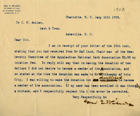
Letters supporting Appalachian National Park movement

-
Letters supporting Appalachian National Park movement
-
Photo Album of the Great Smokey Mountains

-
Cataloochee: fields

-
Unaka and the Pisgah

-
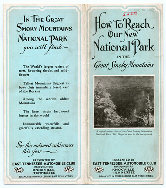
How to Reach our New National Park in the Great Smoky Mountains
-
Subscriptions received by the Appalachian National Park Association
-
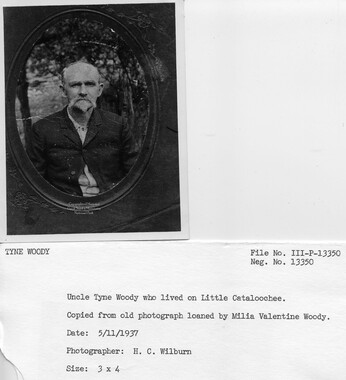
Cataloochee tract 235: R. J. Woody heirs
-
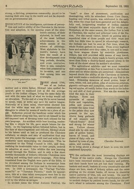
Indian Fair in The High Road
-
Financial receipts and expenditures, 1902

-
Mount LeConte and Clingmans Dome

-
Report of the Secretary of Agriculture in relation to the forests, rivers, and mountains of the southern Appalachian region
-
Legislative act to give consent by South Carolina

-
Financial record of Cash Receipts and Expenditures

-
Requests for information on Appalachian National Park

-
Guyot's list of the peaks of the Great Smokies

-
Appalachian Trail
-
Kephart writes of odd names in the Smoky Mountains
-
Hikers on the trail to Gregory Bald

-
North Carolina view
-
Hardwood Bark, 1923

-
Legislation on behalf of the Appalachian National Park
