Western Carolina University (21)
View all
- Canton Champion Fibre Company (2308)
- Cherokee Traditions (291)
- Civil War in Southern Appalachia (165)
- Craft Revival (1942)
- George Masa Collection (137)
- Great Smoky Mountains - A Park for America (3080)
- Highlights from Western Carolina University (422)
- Horace Kephart (973)
- Journeys Through Jackson (159)
- LGBTQIA+ Archive of Jackson County (89)
- Oral Histories of Western North Carolina (318)
- Picturing Appalachia (6617)
- Stories of Mountain Folk (413)
- Travel Western North Carolina (153)
- Western Carolina University Fine Art Museum Vitreograph Collection (129)
- Western Carolina University Herbarium (92)
- Western Carolina University: Making Memories (738)
- Western Carolina University Publications (2491)
- Western Carolina University Restricted Electronic Theses and Dissertations (146)
- Western North Carolina Regional Maps (71)
- World War II in Southern Appalachia (131)
University of North Carolina Asheville (6)
View all
- Allanstand Cottage Industries (62)
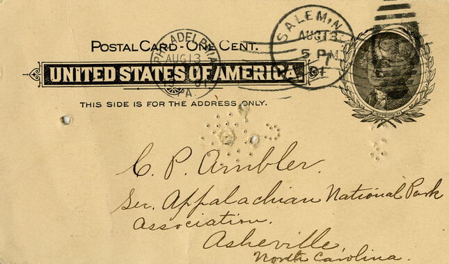
- Appalachian National Park Association (53)
- Bennett, Kelly, 1890-1974 (1463)
- Berry, Walter (76)
- Brasstown Carvers (40)
- Carver, George Washington, 1864?-1943 (26)
- Cathey, Joseph, 1803-1874 (1)
- Champion Fibre Company (233)
- Champion Paper and Fibre Company (297)
- Cherokee Indian Fair Association (16)
- Cherokee Language Program (22)
- Crowe, Amanda (40)
- Edmonston, Thomas Benton, 1842-1907 (7)
- Ensley, A. L. (Abraham Lincoln), 1865-1948 (275)
- Fromer, Irving Rhodes, 1913-1994 (70)
- George Butz (BFS 1907) (46)
- Goodrich, Frances Louisa (120)
- Grant, George Alexander, 1891-1964 (96)
- Heard, Marian Gladys (60)
- Kephart, Calvin, 1883-1969 (15)
- Kephart, Horace, 1862-1931 (313)
- Kephart, Laura, 1862-1954 (67)
- Laney, Gideon Thomas, 1889-1976 (439)
- Masa, George, 1881-1933 (61)
- McElhinney, William Julian, 1896-1953 (44)
- Niggli, Josephina, 1910-1983 (10)
- North Carolina Park Commission (105)
- Osborne, Kezia Stradley (9)
- Owens, Samuel Robert, 1918-1995 (11)
- Penland Weavers and Potters (36)
- Roberts, Vivienne (15)
- Roth, Albert, 1890-1974 (142)
- Schenck, Carl Alwin, 1868-1955 (1)
- Sherrill's Photography Studio (2565)
- Southern Highland Handicraft Guild (127)
- Southern Highlanders, Inc. (71)
- Stalcup, Jesse Bryson (46)
- Stearns, I. K. (213)
- Thompson, James Edward, 1880-1976 (226)
- United States. Indian Arts and Crafts Board (130)
- USFS (683)
- Vance, Zebulon Baird, 1830-1894 (1)
- Weaver, Zebulon, 1872-1948 (58)
- Western Carolina College (230)
- Western Carolina Teachers College (282)
- Western Carolina University (2008)
- Western Carolina University. Mountain Heritage Center (18)
- Whitman, Walt, 1819-1892 (10)
- Wilburn, Hiram Coleman, 1880-1967 (73)
- Williams, Isadora (3)
- Cain, Doreyl Ammons (0)
- Crittenden, Lorraine (0)
- Rhodes, Judy (0)
- Smith, Edward Clark (0)
- Appalachian Region, Southern (3032)
- Asheville (N.C.) (1945)
- Avery County (N.C.) (26)
- Blount County (Tenn.) (195)
- Buncombe County (N.C.) (1680)
- Cherokee County (N.C.) (283)
- Clay County (N.C.) (556)
- Graham County (N.C.) (238)
- Great Smoky Mountains National Park (N.C. and Tenn.) (525)
- Haywood County (N.C.) (3573)
- Henderson County (N.C.) (70)
- Jackson County (N.C.) (4925)
- Knox County (Tenn.) (35)
- Knoxville (Tenn.) (13)
- Lake Santeetlah (N.C.) (10)
- Macon County (N.C.) (421)
- Madison County (N.C.) (216)
- McDowell County (N.C.) (39)
- Mitchell County (N.C.) (135)
- Polk County (N.C.) (35)
- Qualla Boundary (982)
- Rutherford County (N.C.) (78)
- Swain County (N.C.) (2185)
- Transylvania County (N.C.) (270)
- Watauga County (N.C.) (12)
- Waynesville (N.C.) (86)
- Yancey County (N.C.) (72)
- Aerial Photographs (3)
- Aerial Views (60)
- Albums (books) (4)
- Articles (1)
- Artifacts (object Genre) (228)
- Bibliographies (1)
- Biography (general Genre) (2)
- Cards (information Artifacts) (38)
- Clippings (information Artifacts) (192)
- Copybooks (instructional Materials) (3)
- Crafts (art Genres) (622)
- Depictions (visual Works) (21)
- Design Drawings (1)
- Digital Moving Image Formats (2)
- Drawings (visual Works) (185)
- Envelopes (101)
- Exhibitions (events) (1)
- Facsimiles (reproductions) (1)
- Fiction (general Genre) (4)
- Financial Records (12)
- Fliers (printed Matter) (67)
- Glass Plate Negatives (381)
- Guidebooks (2)
- Internegatives (10)
- Interviews (823)
- Land Surveys (102)
- Letters (correspondence) (1045)
- Manuscripts (documents) (618)
- Maps (documents) (177)
- Memorandums (25)
- Minutes (administrative Records) (59)
- Negatives (photographs) (6090)
- Newsletters (1290)
- Newspapers (2)
- Notebooks (8)
- Occupation Currency (1)
- Paintings (visual Works) (1)
- Pen And Ink Drawings (1)
- Periodicals (194)
- Personal Narratives (10)
- Photographs (12977)
- Plans (maps) (1)
- Poetry (6)
- Portraits (4568)
- Postcards (329)
- Programs (documents) (181)
- Publications (documents) (2444)
- Questionnaires (65)
- Relief Prints (26)
- Sayings (literary Genre) (1)
- Scrapbooks (282)
- Sheet Music (2)
- Slides (photographs) (402)
- Songs (musical Compositions) (2)
- Sound Recordings (802)
- Specimens (92)
- Speeches (documents) (18)
- Tintypes (photographs) (8)
- Transcripts (329)
- Text Messages (0)
- A.L. Ensley Collection (275)
- Appalachian Industrial School Records (7)
- Appalachian National Park Association Records (336)
- Axley-Meroney Collection (2)
- Bayard Wootten Photograph Collection (20)
- Bethel Rural Community Organization Collection (7)
- Blumer Collection (5)
- C.W. Slagle Collection (20)
- Canton Area Historical Museum (2110)
- Carlos C. Campbell Collection (462)
- Cataloochee History Project (64)
- Cherokee Studies Collection (4)
- Daisy Dame Photograph Album (5)
- Daniel Boone VI Collection (1)
- Doris Ulmann Photograph Collection (112)
- Elizabeth H. Lasley Collection (1)
- Elizabeth Woolworth Szold Fleharty Collection (4)
- Frank Fry Collection (95)
- George Masa Collection (173)
- Gideon Laney Collection (452)
- Hazel Scarborough Collection (2)
- Hiram C. Wilburn Papers (28)
- Historic Photographs Collection (236)
- Horace Kephart Collection (861)
- Humbard Collection (33)
- Hunter and Weaver Families Collection (1)
- I. D. Blumenthal Collection (4)
- Isadora Williams Collection (4)
- Jesse Bryson Stalcup Collection (47)
- Jim Thompson Collection (224)
- John B. Battle Collection (7)
- John C. Campbell Folk School Records (80)
- John Parris Collection (6)
- Judaculla Rock project (2)
- Kelly Bennett Collection (1482)
- Love Family Papers (11)
- Major Wiley Parris Civil War Letters (3)
- Map Collection (12)
- McFee-Misemer Civil War Letters (34)
- Mountain Heritage Center Collection (4)
- Norburn - Robertson - Thomson Families Collection (44)
- Pauline Hood Collection (7)
- Pre-Guild Collection (2)
- Qualla Arts and Crafts Mutual Collection (12)
- R.A. Romanes Collection (681)
- Rosser H. Taylor Collection (1)
- Samuel Robert Owens Collection (94)
- Sara Madison Collection (144)
- Sherrill Studio Photo Collection (2558)
- Smoky Mountains Hiking Club Collection (616)
- Stories of Mountain Folk - Radio Programs (374)
- The Reporter, Western Carolina University (510)
- Venoy and Elizabeth Reed Collection (16)
- WCU Gender and Sexuality Oral History Project (36)
- WCU Mountain Heritage Center Oral Histories (25)
- WCU Oral History Collection - Mountain People, Mountain Lives (71)
- WCU Students Newspapers Collection (1923)
- Western North Carolina Tomorrow Black Oral History Project (69)
- William Williams Stringfield Collection (2)
- Zebulon Weaver Collection (109)
- African Americans (390)
- Appalachian Trail (35)
- Artisans (521)
- Cherokee art (84)
- Cherokee artists -- North Carolina (10)
- Cherokee language (21)
- Cherokee pottery (101)
- Cherokee women (208)
- Church buildings (190)
- Civilian Conservation Corps (U.S.) (111)
- College student newspapers and periodicals (2012)
- Dams (108)
- Dance (1023)
- Education (222)
- Floods (63)
- Folk music (1015)
- Forced removal, 1813-1903 (2)
- Forest conservation (220)
- Forests and forestry (1198)
- Gender nonconformity (4)
- Great Smoky Mountains National Park (N.C. and Tenn.) (181)
- Hunting (47)
- Landscape photography (25)
- Logging (122)
- Maps (83)
- Mines and mineral resources (9)
- North Carolina -- Maps (18)
- Paper industry (38)
- Postcards (255)
- Pottery (135)
- Railroad trains (72)
- Rural electrification -- North Carolina, Western (3)
- School integration -- Southern States (2)
- Segregation -- North Carolina, Western (5)
- Slavery (5)
- Sports (452)
- Storytelling (243)
- Waterfalls -- Great Smoky Mountains (N.C. and Tenn.) (66)
- Weaving -- Appalachian Region, Southern (280)
- Wood-carving -- Appalachian Region, Southern (328)
- World War, 1939-1945 (173)
Senate Bill 781

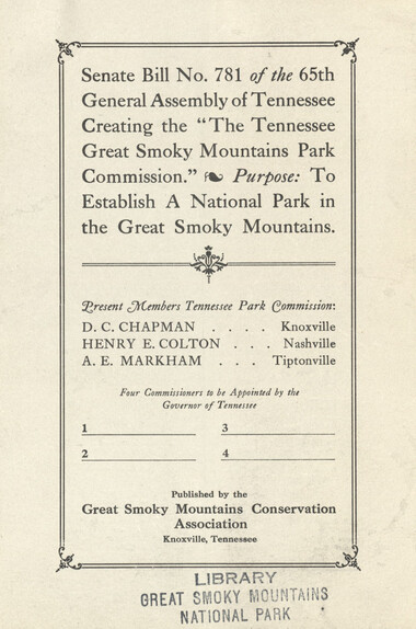
Senate Bill 781
GSMNP_10184_15_01_07


Item
Item’s are ‘child’ level descriptions to ‘parent’ objects, (e.g. one page of a whole book).
-
-
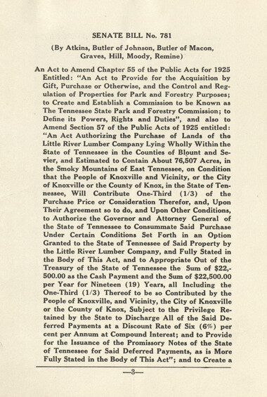
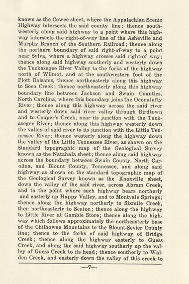
known as the Cowee sheet, where the Appalachian Scenic Highway intersects the said county line; thence southwesterly along said highway to a point where this highway intersects the right-of-way line of the Asheville and Murphy Branch of the Southern Railroad; thence along the northern boundary of said right-of-way to a point near Sylva, where a highway crosses said right-of way; thence along said highway southerly and westerly down the Tuckasegee River Valley to the forks of the highway north of Wilmot, and at the southwestern foot of the Plott Balsams, thence northeasterly along this highway to Soco Creek; thence northeasterly along this highway boundary line between Jackson and Swain Counties, North Carolina, where this boundary joins the Oconalufty River; thence along this highway across the said river and westerly down said river valley through Birdtown and to Cooper's Creek, near its junction with the Tuckasegee River; thence along this highway westerly down the valley of said river to its junction with the Little Tennessee River; thence westerly along the highway down the valley of the Little Tennessee River, as shown on the Standard topographic map of the Geological Survey known as the Natahala sheet; thence along said highway across the boundary between Swain County, North Carolina, and Blount County, Tennessee, and along said highway as shown on the standard topographic map of the Geological Survey known as the Knoxville sheet, down the valley of the said river, across Abram Creek, and to the point where such highway bears northerly and easterly up Happy Valley, and to Montvale Springs; thence along the highway northerly to Sixmile Creek, then northeasterly to Seaton; thence along the highway to Little River at Gamble Store; thence along the highway which follows approximately the northeasterly base of the Chilhowee Mountains to the Blount-Sevier County line; thence to the forks of said highway of Bridge Creek; thence along the highway easterly to Guess Creek, and along the said highway southerly up the valley of Guess Creek to its head; thence southerly to Wal- den Creek, and easterly down the valley of this creek to
Object
Object’s are ‘parent’ level descriptions to ‘children’ items, (e.g. a book with pages).
-
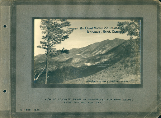
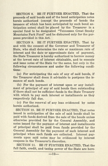
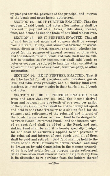
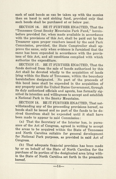
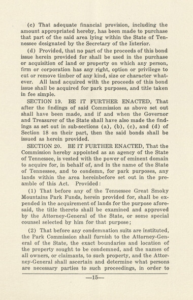
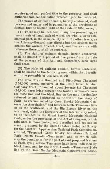
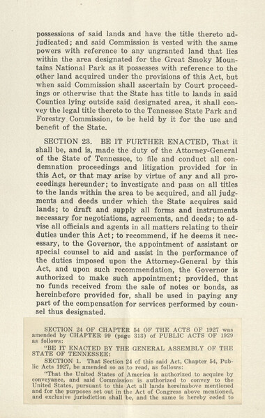
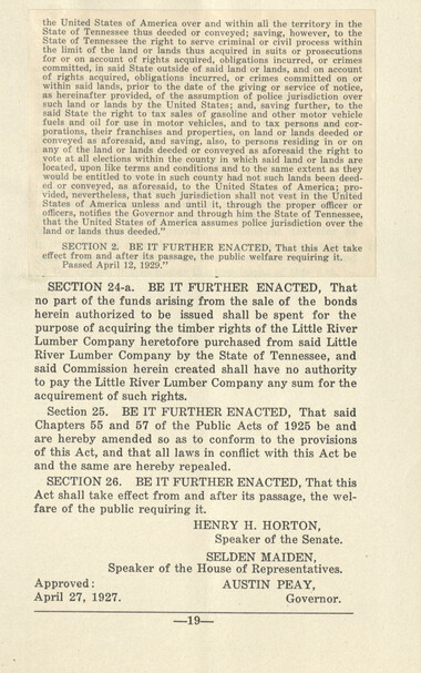
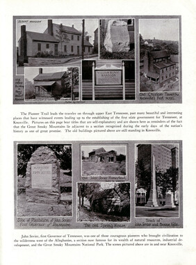
Senate bill 781 was presented to the 65th General Assembly of Tennessee to establish the “Tennessee Great Smoky Mountains Park Commission" for the purpose of establishing the Great Smoky Mountains National Park. The U.S. Congress had agreed to create the park only if the states acquired the land. In 1924, North Carolina established the North Carolina Park Commission to set boundaries and purchase land. By 1931, both North Carolina and Tennessee had acquired over 100,000 acres that were deeded to the federal government and placed under the management of the Secretary of the Interior.
-
Related items
-
The Canton Enterprise Volume 13 Number 17
-
The Canton Enterprise Volume 13 Number 16
-
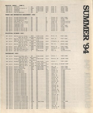
Western Carolinian Volume 63 (64) Number 15
-
Western Carolinian Volume 63 (64) Number 03
-
Western Carolinian April 23, 1941
-
Western Carolinian Volume 55 Number 09
-
Western Carolinian Volume 67 Number 10

-
Western Carolinian Volume 76 Number 03

-
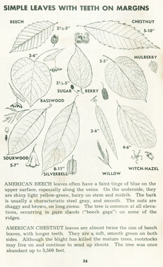
Catalogue of Mountain Handicrafts pages 26 &27

-
Western Carolinian Volume 68 Number 07
-
Western Carolinian Volume 59 Number 07
-
Western Carolinian Volume 69 Number 12
-
Western Carolinian Volume 43 Number 30
-
Western Carolinian Volume 71 Number 02
-
Western Carolinian Volume 32 Number 14
-
Western Carolinian Volume 46 Number 21, February 25, 1982
-
Western Carolinian Volume 43 Number 25

-
Western Carolinian Volume 70 Number 05
-
Western Carolinian Volume 50 (51) Number 08
-
Western Carolinian Volume 51 Number 02

-
Western Carolinian Volume 46 Number 04
-
Western Carolinian Volume 42 Number 32
-
Western Carolinian Volume 67 Number 05

-
Western Carolinian Volume 26 Number 01
-
Western Carolinian Volume 11 Number 04
-
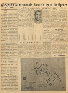
Western Carolinian, August 25, 1994 (Volume 60 Number 03)
-
Nature Magazine: Carolina number
-
Western Carolinian Volume 59 Number 22 (21)
-
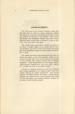
Cherokee Indian Fair 1933

-
Cherokee Indian Fair 1935
-
Handbook/ 1933/ Smoky Mountains Hiking Club
-
Western Carolinian Volume 57 Number 12
Part of Collection
Great Smoky Mountains - A Park for America
-
Trees of the Great Smoky Mountains National Park
-
Appalachian National Park: Synopsis of work accomplished
-
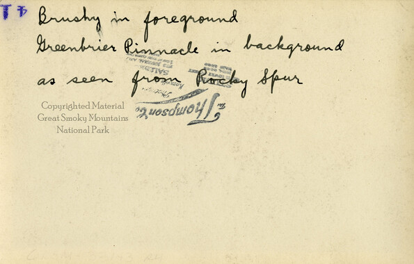
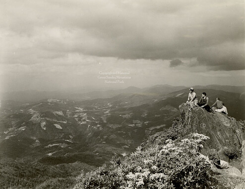
Brushy and Greenbrier Pinnacle
-
Senate Committee on Agriculture presentation
-
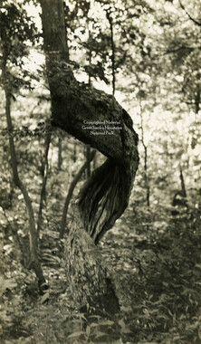
Twisted tree
-
Mount Cammerer
-
Cataloochee tract 221: Will H. Palmer
-
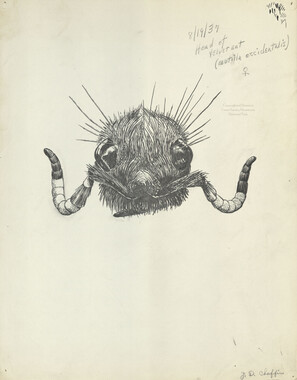
Velvet ant (Mutilla occidentalis)
-
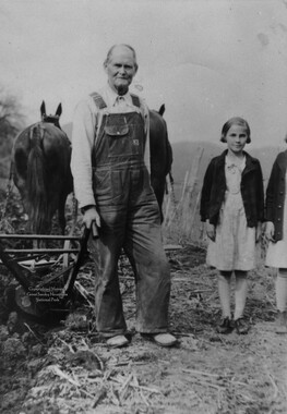
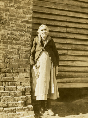
Mag Caldwell
-
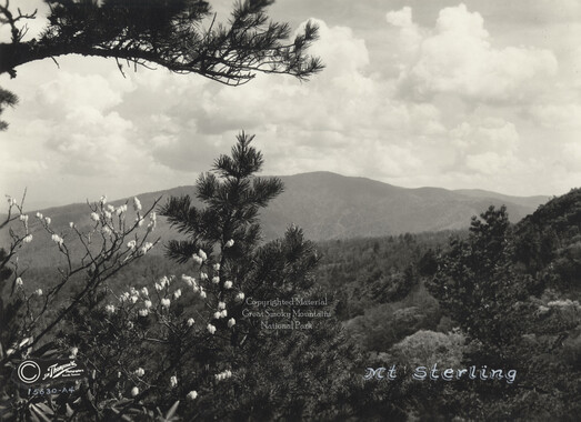
Mt. Sterling
-
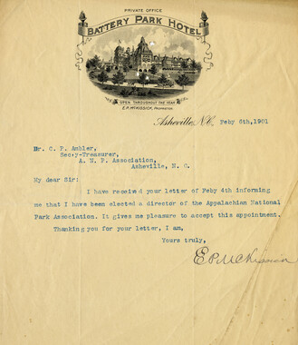
Correspondence regarding the election of officers
-
Glimpses of our National Monuments
-
Walter Berry at Eagle Rocks

-
Memorial presentation to Congress

-
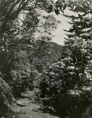
Rhododendron along trail
-
National Parks Bulletin

-
Financial receipts and expenditures, 1900

-
Facts and Figures Concerning the Champion Fibre Company

-
Great Smoky Mountains National Park / Land of the Everlasting Hills
-
Knoxville and the Great Smokies

-
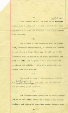
By-laws of the Appalachian National Park Association
-
Requests for information on Appalachian National Park
-
Mount LeConte via Rainbow Falls

-
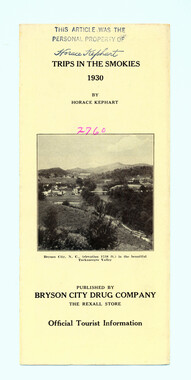
Trips in the Smokies, 1930
-
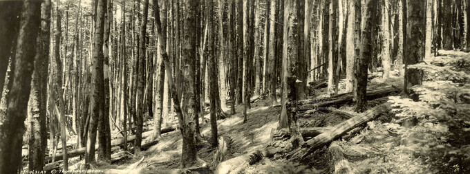
Balsam Forest on Mount LeConte
-
Fields and fences, Cataloochee, N.C.

-
Cataloochee tract 215: George H. Caldwell

-
Yellow Creek Mountain

-
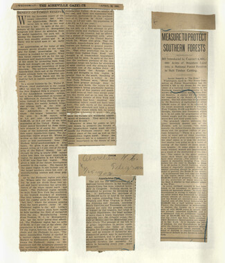
Appalachian National Park Association Newspaper Clippings, 1899-1902
-
Phacelia Buds

-
Activities of the Appalachian National Park Association and the Appalachian National Forest Reserve Association: 1899-1906

-
Photo Album of the Great Smokey Mountains