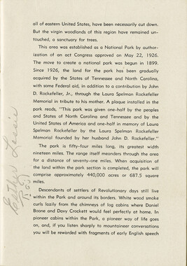
- Great Smoky Mountains - A Park for America (24)
- Canton Champion Fibre Company (0)
- Cherokee Traditions (0)
- Civil War in Southern Appalachia (0)
- Craft Revival (0)
- Highlights from Western Carolina University (0)
- Horace Kephart (0)
- Journeys Through Jackson (0)
- LGBTQIA+ Archive of Jackson County (0)
- Oral Histories of Western North Carolina (0)
- Picturing Appalachia (0)
- Stories of Mountain Folk (0)
- Travel Western North Carolina (0)
- Western Carolina University Fine Art Museum Vitreograph Collection (0)
- Western Carolina University Herbarium (0)
- Western Carolina University: Making Memories (0)
- Western Carolina University Publications (0)
- Western Carolina University Restricted Electronic Theses and Dissertations (0)
- Western North Carolina Regional Maps (0)
- World War II in Southern Appalachia (0)
- Faces of Asheville (0)
- Forestry in Western North Carolina (0)
- Grove Park Inn Photograph Collection (0)
- Isaiah Rice Photograph Collection (0)
- Morse Family Chimney Rock Park Collection (0)
- Picturing Asheville and Western North Carolina (0)
- Allanstand Cottage Industries (62)
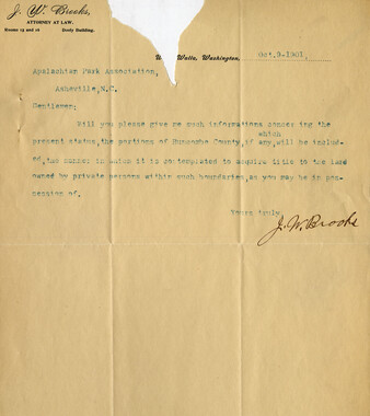
- Appalachian National Park Association (53)
- Bennett, Kelly, 1890-1974 (1388)
- Berry, Walter (76)
- Brasstown Carvers (40)
- Carver, George Washington, 1864?-1943 (26)
- Cathey, Joseph, 1803-1874 (1)
- Champion Fibre Company (233)
- Champion Paper and Fibre Company (297)
- Cherokee Indian Fair Association (16)
- Cherokee Language Program (22)
- Crowe, Amanda (40)
- Edmonston, Thomas Benton, 1842-1907 (7)
- Ensley, A. L. (Abraham Lincoln), 1865-1948 (275)
- Fromer, Irving Rhodes, 1913-1994 (70)
- George Butz (BFS 1907) (46)
- Goodrich, Frances Louisa (120)
- Grant, George Alexander, 1891-1964 (96)
- Heard, Marian Gladys (60)
- Kephart, Calvin, 1883-1969 (15)
- Kephart, Horace, 1862-1931 (313)
- Kephart, Laura, 1862-1954 (39)
- Laney, Gideon Thomas, 1889-1976 (439)
- Masa, George, 1881-1933 (61)
- McElhinney, William Julian, 1896-1953 (44)
- Niggli, Josephina, 1910-1983 (10)
- North Carolina Park Commission (105)
- Osborne, Kezia Stradley (9)
- Owens, Samuel Robert, 1918-1995 (11)
- Penland Weavers and Potters (36)
- Roberts, Vivienne (15)
- Roth, Albert, 1890-1974 (142)
- Schenck, Carl Alwin, 1868-1955 (1)
- Sherrill's Photography Studio (2565)
- Southern Highland Handicraft Guild (127)
- Southern Highlanders, Inc. (71)
- Stalcup, Jesse Bryson (46)
- Stearns, I. K. (213)
- Thompson, James Edward, 1880-1976 (226)
- United States. Indian Arts and Crafts Board (130)
- USFS (683)
- Vance, Zebulon Baird, 1830-1894 (1)
- Weaver, Zebulon, 1872-1948 (58)
- Western Carolina College (230)
- Western Carolina Teachers College (282)
- Western Carolina University (1794)
- Western Carolina University. Mountain Heritage Center (18)
- Whitman, Walt, 1819-1892 (10)
- Wilburn, Hiram Coleman, 1880-1967 (73)
- Williams, Isadora (3)
- Cain, Doreyl Ammons (0)
- Crittenden, Lorraine (0)
- Rhodes, Judy (0)
- Smith, Edward Clark (0)
- 1850s (1)
- 1860s (1)
- 1870s (3)
- 1880s (2)
- 1900s (2)
- 1910s (4)
- 1920s (23)
- 1930s (20)
- 1940s (10)
- 1950s (4)
- 1970s (4)
- 1980s (3)
- 1990s (3)
- 2000s (21)
- 1600s (0)
- 1700s (0)
- 1800s (0)
- 1810s (0)
- 1820s (0)
- 1830s (0)
- 1840s (0)
- 1890s (0)
- 1960s (0)
- 2010s (0)
- 2020s (0)
- Great Smoky Mountains National Park (N.C. and Tenn.) (1)
- Haywood County (N.C.) (24)
- Appalachian Region, Southern (0)
- Asheville (N.C.) (0)
- Avery County (N.C.) (0)
- Blount County (Tenn.) (0)
- Buncombe County (N.C.) (0)
- Cherokee County (N.C.) (0)
- Clay County (N.C.) (0)
- Graham County (N.C.) (0)
- Henderson County (N.C.) (0)
- Jackson County (N.C.) (0)
- Knox County (Tenn.) (0)
- Knoxville (Tenn.) (0)
- Lake Santeetlah (N.C.) (0)
- Macon County (N.C.) (0)
- Madison County (N.C.) (0)
- McDowell County (N.C.) (0)
- Mitchell County (N.C.) (0)
- Polk County (N.C.) (0)
- Qualla Boundary (0)
- Rutherford County (N.C.) (0)
- Swain County (N.C.) (0)
- Transylvania County (N.C.) (0)
- Watauga County (N.C.) (0)
- Waynesville (N.C.) (0)
- Yancey County (N.C.) (0)
- Clippings (information Artifacts) (7)
- Land Surveys (22)
- Letters (correspondence) (3)
- Manuscripts (documents) (8)
- Maps (documents) (9)
- Photographs (19)
- Portraits (8)
- Publications (documents) (23)
- Aerial Photographs (0)
- Aerial Views (0)
- Albums (books) (0)
- Articles (0)
- Artifacts (object Genre) (0)
- Bibliographies (0)
- Biography (general Genre) (0)
- Cards (information Artifacts) (0)
- Crafts (art Genres) (0)
- Depictions (visual Works) (0)
- Design Drawings (0)
- Drawings (visual Works) (0)
- Envelopes (0)
- Facsimiles (reproductions) (0)
- Fiction (general Genre) (0)
- Financial Records (0)
- Fliers (printed Matter) (0)
- Glass Plate Negatives (0)
- Guidebooks (0)
- Internegatives (0)
- Interviews (0)
- Memorandums (0)
- Minutes (administrative Records) (0)
- Negatives (photographs) (0)
- Newsletters (0)
- Newspapers (0)
- Occupation Currency (0)
- Paintings (visual Works) (0)
- Pen And Ink Drawings (0)
- Periodicals (0)
- Personal Narratives (0)
- Plans (maps) (0)
- Poetry (0)
- Postcards (0)
- Programs (documents) (0)
- Questionnaires (0)
- Scrapbooks (0)
- Sheet Music (0)
- Slides (photographs) (0)
- Songs (musical Compositions) (0)
- Sound Recordings (0)
- Specimens (0)
- Speeches (documents) (0)
- Text Messages (0)
- Tintypes (photographs) (0)
- Transcripts (0)
- Video Recordings (physical Artifacts) (0)
- Vitreographs (0)
- Cataloochee History Project (2)
- A.L. Ensley Collection (0)
- Appalachian Industrial School Records (0)
- Appalachian National Park Association Records (0)
- Axley-Meroney Collection (0)
- Bayard Wootten Photograph Collection (0)
- Bethel Rural Community Organization Collection (0)
- Blumer Collection (0)
- C.W. Slagle Collection (0)
- Canton Area Historical Museum (0)
- Carlos C. Campbell Collection (0)
- Cherokee Studies Collection (0)
- Daisy Dame Photograph Album (0)
- Daniel Boone VI Collection (0)
- Doris Ulmann Photograph Collection (0)
- Elizabeth H. Lasley Collection (0)
- Elizabeth Woolworth Szold Fleharty Collection (0)
- Frank Fry Collection (0)
- George Masa Collection (0)
- Gideon Laney Collection (0)
- Hazel Scarborough Collection (0)
- Hiram C. Wilburn Papers (0)
- Historic Photographs Collection (0)
- Horace Kephart Collection (0)
- Humbard Collection (0)
- Hunter and Weaver Families Collection (0)
- I. D. Blumenthal Collection (0)
- Isadora Williams Collection (0)
- Jesse Bryson Stalcup Collection (0)
- Jim Thompson Collection (0)
- John B. Battle Collection (0)
- John C. Campbell Folk School Records (0)
- John Parris Collection (0)
- Judaculla Rock project (0)
- Kelly Bennett Collection (0)
- Love Family Papers (0)
- Major Wiley Parris Civil War Letters (0)
- Map Collection (0)
- McFee-Misemer Civil War Letters (0)
- Mountain Heritage Center Collection (0)
- Norburn - Robertson - Thomson Families Collection (0)
- Pauline Hood Collection (0)
- Pre-Guild Collection (0)
- Qualla Arts and Crafts Mutual Collection (0)
- R.A. Romanes Collection (0)
- Rosser H. Taylor Collection (0)
- Samuel Robert Owens Collection (0)
- Sara Madison Collection (0)
- Sherrill Studio Photo Collection (0)
- Smoky Mountains Hiking Club Collection (0)
- Stories of Mountain Folk - Radio Programs (0)
- The Reporter, Western Carolina University (0)
- Venoy and Elizabeth Reed Collection (0)
- WCU Gender and Sexuality Oral History Project (0)
- WCU Mountain Heritage Center Oral Histories (0)
- WCU Oral History Collection - Mountain People, Mountain Lives (0)
- WCU Students Newspapers Collection (0)
- Western North Carolina Tomorrow Black Oral History Project (0)
- William Williams Stringfield Collection (0)
- Zebulon Weaver Collection (0)
- Church buildings (2)
- Maps (5)
- African Americans (0)
- Appalachian Trail (0)
- Artisans (0)
- Cherokee art (0)
- Cherokee artists -- North Carolina (0)
- Cherokee language (0)
- Cherokee pottery (0)
- Cherokee women (0)
- Civilian Conservation Corps (U.S.) (0)
- College student newspapers and periodicals (0)
- Dams (0)
- Dance (0)
- Education (0)
- Floods (0)
- Folk music (0)
- Forced removal, 1813-1903 (0)
- Forest conservation (0)
- Forests and forestry (0)
- Gender nonconformity (0)
- Great Smoky Mountains National Park (N.C. and Tenn.) (0)
- Hunting (0)
- Landscape photography (0)
- Logging (0)
- Mines and mineral resources (0)
- North Carolina -- Maps (0)
- Paper industry (0)
- Postcards (0)
- Pottery (0)
- Railroad trains (0)
- Rural electrification -- North Carolina, Western (0)
- School integration -- Southern States (0)
- Segregation -- North Carolina, Western (0)
- Slavery (0)
- Sports (0)
- Storytelling (0)
- Waterfalls -- Great Smoky Mountains (N.C. and Tenn.) (0)
- Weaving -- Appalachian Region, Southern (0)
- Wood-carving -- Appalachian Region, Southern (0)
- World War, 1939-1945 (0)
- StillImage (19)
- Text (24)
- MovingImage (0)
- Sound (0)
Cataloochee tract 214: Eldredge Caldwell – Levi

Cataloochee tract 214: Eldredge Caldwell – Levi
GSMNP_Cata-214
Cataloochee tract 214: Eldredge Caldwell – Levi
GSMNP_80235_066
Cataloochee tract 214: Eldredge Caldwell – Levi
GSMNP_80235_a_00
Cataloochee tract 214: Eldredge Caldwell – Levi
GSMNP_80235_03_00
Cataloochee tract 214: Eldredge Caldwell – Levi
GSMNP_80235_05_00
Cataloochee tract 214: Eldredge Caldwell – Levi
GSMNP_Cata-214_107_Caldwell
Cataloochee tract 214: Eldredge Caldwell – Levi
GSMNP_Cata-214_108_03_Carroll
Cataloochee tract 214: Eldredge Caldwell – Levi
GSMNP_Cata-214_CT-10_a
Cataloochee tract 214: Eldredge Caldwell – Levi
GSMNP_Cata-214_CT-10_b
Cataloochee tract 214: Eldredge Caldwell – Levi
GSMNP_Cata-214_109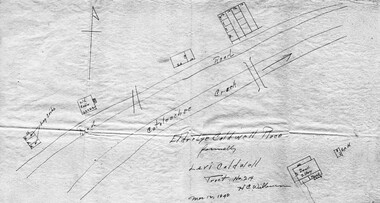
Cataloochee tract 214: Eldredge Caldwell – Levi
GSMNP_02120_III-B-9189_a
Cataloochee tract 214: Eldredge Caldwell – Levi
GSMNP_02120_III-B-9189_b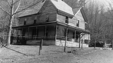
Cataloochee tract 214: Eldredge Caldwell – Levi
GSMNP_02120_II-B-(6)-8009_a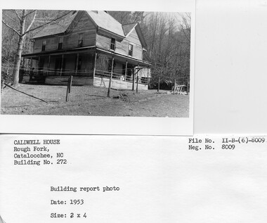
Cataloochee tract 214: Eldredge Caldwell – Levi
GSMNP_02120_II-B-(6)-8009_b
Cataloochee tract 214: Eldredge Caldwell – Levi
GSMNP_02120_II-B-(6)-8010_a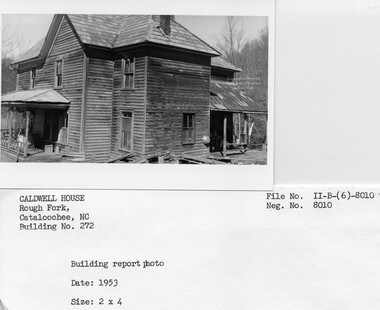
Cataloochee tract 214: Eldredge Caldwell – Levi
GSMNP_02120_II-B-(6)-8010_b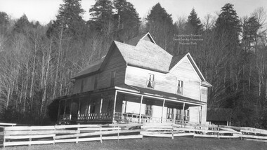
Cataloochee tract 214: Eldredge Caldwell – Levi
GSMNP_02120_II-B-(6)-8011_a
Cataloochee tract 214: Eldredge Caldwell – Levi
GSMNP_02120_II-B-(6)-8011_b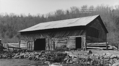
Cataloochee tract 214: Eldredge Caldwell – Levi
GSMNP_02120_II-B-(6)-8012_a
Cataloochee tract 214: Eldredge Caldwell – Levi
GSMNP_02120_III-B-4867_03
Cataloochee tract 214: Eldredge Caldwell – Levi
GSMNP_02120_II-B-(6)-8013_a
Cataloochee tract 214: Eldredge Caldwell – Levi
GSMNP_02120_II-B-(6)-8013_b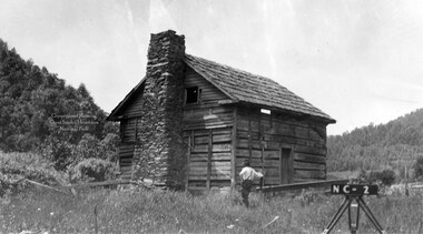
Cataloochee tract 214: Eldredge Caldwell – Levi
GSMNP_02120_III-B-10005_a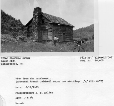
Cataloochee tract 214: Eldredge Caldwell – Levi
GSMNP_02120_III-B-10005_b
Cataloochee tract 214: Eldredge Caldwell – Levi
GSMNP_02120_III-B-10006_a
Cataloochee tract 214: Eldredge Caldwell – Levi
GSMNP_02120_III-B-10006_b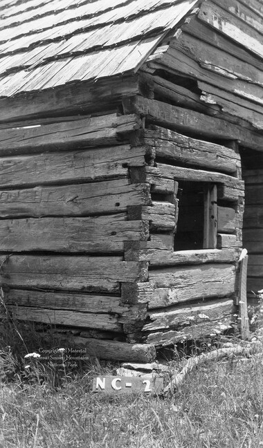
Cataloochee tract 214: Eldredge Caldwell – Levi
GSMNP_02120_III-B-10007_a
Cataloochee tract 214: Eldredge Caldwell – Levi
GSMNP_02120_III-B-10007_b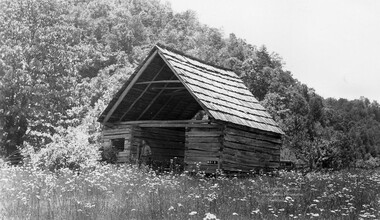
Cataloochee tract 214: Eldredge Caldwell – Levi
GSMNP_02120_III-B-10008_a
Cataloochee tract 214: Eldredge Caldwell – Levi
GSMNP_02120_III-B-10008_b
Cataloochee tract 214: Eldredge Caldwell – Levi
GSMNP_02120_III-B-10009_a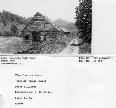
Cataloochee tract 214: Eldredge Caldwell – Levi
GSMNP_02120_III-B-10009_b
Cataloochee tract 214: Eldredge Caldwell – Levi
GSMNP_02120_III-B-10010_a
Cataloochee tract 214: Eldredge Caldwell – Levi
GSMNP_02120_III-B-10010_b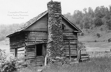
Cataloochee tract 214: Eldredge Caldwell – Levi
GSMNP_02120_III-B-10105_a
Cataloochee tract 214: Eldredge Caldwell – Levi
GSMNP_02120_III-B-10105_b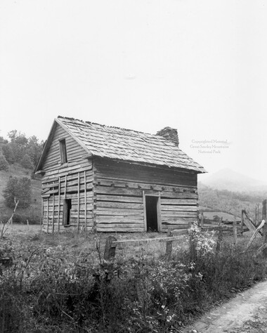
Cataloochee tract 214: Eldredge Caldwell – Levi
GSMNP_02120_III-B-10433_a
Cataloochee tract 214: Eldredge Caldwell – Levi
GSMNP_02120_III-B-10433_b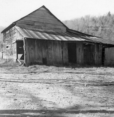
Cataloochee tract 214: Eldredge Caldwell – Levi
GSMNP_02120_III-B-4867_a
Cataloochee tract 214: Eldredge Caldwell – Levi
GSMNP_02120_III-B-4867_b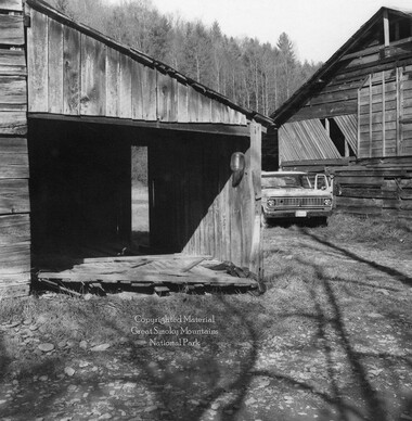
Cataloochee tract 214: Eldredge Caldwell – Levi
GSMNP_02120_III-B-4868_a
Cataloochee tract 214: Eldredge Caldwell – Levi
GSMNP_02120_III-B-4868_b
Cataloochee tract 214: Eldredge Caldwell – Levi
GSMNP_02120_III-B-9190_a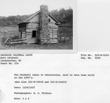
Cataloochee tract 214: Eldredge Caldwell – Levi
GSMNP_02120_III-B-9190_b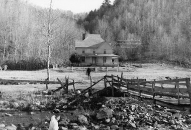
Cataloochee tract 214: Eldredge Caldwell – Levi
GSMNP_02120_III-B-9191_a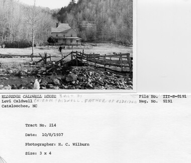
Cataloochee tract 214: Eldredge Caldwell – Levi
GSMNP_02120_III-B-9191_b
Cataloochee tract 214: Eldredge Caldwell – Levi
GSMNP_Cata-214_Palmer_10
Cataloochee tract 214: Eldredge Caldwell – Levi
GSMNP_Cata-214_Palmer_17Item’s are ‘child’ level descriptions to ‘parent’ objects, (e.g. one page of a whole book).
-
-
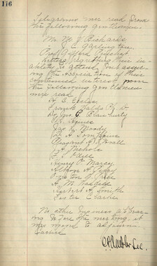
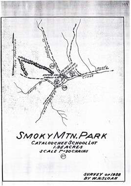
CATALOOCHEE HISTORIC DISTRICT: CULTURAL LANDSCAPE REPORT GREAT SMoKY MoUNTAINS NATIONAL PARK January 2000 Dianne L. Flaugh Historical Landscape Architect Cultural Resources Resource Management Great Smoky Mountains National Park National Park Service Hiram Caldwell Tract (214) This tract includes the Hiram Caldwell Cemetery and sites associated with Levi Caldwell. Location Tract 214, totaling 122.98 acres, straddles Rough Fork south of its juncture with Shanty Branch. The Charles Ray Caldwell tract (213) lies along its southwest boundary and the Thomas Caldwell tract (212a) lies along its northeast boundary. The most of the tract is on the west side ofRough Fork. History Tradition holds that Levi and Mary Caldwell settled in Cataloochee in 1841. In 1858, Levi Caldwell recorded the purchase of the 150 acres of land that comprises this tract. After the death of Levi Caldwell in 1864, the tract passed to his children. His heirs deeded the land to Levi's son Hiram in 1878. In 1918, Hiram and his wife Lizzie conveyed the tract to their son R. Eldredge Caldwell in return for support. The NCPC acquired the property in 1930 for $10,300. The Eldredge Caldwell family maintained ....._____/ residency, moving out in 1934. William and Eleanor Palmer, and later Lush Caldwell subsequently leased the property. Lush Caldwell moved out of the house in 1968. Levi and Mary Caldwell raised a family of twelve children in Cataloochee. They supported themselves through the crops and livestock they raised. Agricultural census records from 1860 show Levi Caldwell as the owner of one hundred fifty acres of land, including thirty-five cleared acres. He grew primarily corn ·and smaller crops of wheat, oats, tobacco, peas, potatoes, sorghum, and grass seed. He also harvested one ton ofhay. His livestock in 1860 consisted of five horses, two mules or asses, five milk cows, fourteen cattle, twenty-one hogs, and eight sheep. Following the death of Levi, Mary Ann Caldwell married Jonathan Woody. Their combined household in 1870, included the Woody children Stephen, Jackson, and Rachael. Caldwell children included Ruben, Hiram, John, Doctor, George, and Mary. The 1870 and 1880 Agricultural Census information for the property is recorded under Jonathan Woody. Woody owned other properties and the census combines the agricultural production information from all these properties. Woody did record orchard crops beginning in 1870, and it is likely that the orchard was on property settled by Levi Caldwell. The 1880 Agricultural Census notes a one-acre orchard containing one hundred bearing apple trees. The Jonathan Woody household in 1880, included Hiram Caldwell and his wife Mary Elizabeth Howell Caldwell.1 During the years that Hiram farmed this tract he was known to have a large orchard and raise crops and livestock. Family members tell of crops of hay and corn used to feed about two hundred head of cattle. He wintered these cattle in '-'---- two large barns on this parcel. He also raised sheep, hogs, and turkeys as cash crops. Following his death in 1922, his son Eldredge continued to farm the property and raise ~ I I I I I I I ~ ~" I I I I I ,I. "--..- ' CHAPTER 4: INDNIDUAL TRAcTS . 67 livestock until moving from the valley in 1934.2 Hiram began the construction ofa new home on the east side of Rough Fork beginning in 1897. Material for the house came from trees harvested on the property. The nine-room house, completed in 1903/04, housed not only the Hiram Caldwell family but also visiting relatives and paying guests. Family members relate that these paying guests included vacationers and fisherman. Schoolteachers also boarded at the house.3 The agricultural use ofthe parcel continued after Eldredge Caldwell left the valley. First William Palmer and then Lush Caldwell leased the property. While Lush Caldwell leased the property he raised corn and tobacco in the large field southwest of the barn. As the least rocky of the nearby fields this was the area best suited to these crops. Lush kept the land productive by applying fertilizer and lime to the fields. Other fields in the valley were used as pasture or hay fields for the approximately sixty head of cattle that Lush raised. The family also raised a couple milk cows and hogs for family use. Draft horses were used until 1953 when Lush purchased his first tractor. Even with a tractor, farming in Cataloochee entailed hand labor. Lush and his family hand stacked hay in the fields until ceasing his farm operation in 1968.4 Vegetation NCPC records indicate that the Eldredge Caldwell tract consisted of seventy acres of bottomland, and thirty-three acres of woodland. Approximately twenty acres is unaccounted for but may be the homestead area. Although no orchard is described in the NCPC records, family tradition holds that Hiram Caldwell had a productive orchard on this parcel. Survey drawings (ca. 1935) marked the location ten large apple trees that may have been the remnants of a larger orchard. Although scattered, these trees give the appearance of having been planted on a grid. Another grouping of peach and apple trees was recorded in the level area behind the Levi Caldwell cabin. One family member recalls some of the ornamentals on the property. The front porch had porch swing at the left end and a wisteria vine planted nearby rambled all the way across the porch. There were purple lilacs and other plants common to the valley. These included red rambling roses, dahlias, hollyhocks, iris, daffodils, yucca, and gladiolas.5 Circulation The old settler road ran along the north bank ofRough Fork Creek through this tract. A trail/road forded Rough Fork south of the Hiram Caldwell house and ran through the field south of the house, extending up the stream branch behind house up to tracts above Nellie Ridge. Structures, Furnishings, and Objects At the time the parcel was acquired by the NCPC structures included a nine-room frame house (ca. 1898/1904), ten-stall barn, two-stall bam (log corncrib), and two-room cabin. A number of other structures are also known to have existed on site including a 68 C ULTIJRAL LANDSCAPE REPORT: CATALOOCHEE HISTORIC DISTRICT springhouse, smokehouse/woodshed, privy, log sheep barn, and cattle barn. The cabin, log corncrib, and ten-stall barn are all said to have been built by Levi Caldwell. The cabin (ca. 1858) and corncrib stood strung along the old settler road on the west bank of Rough Fork. The ten-stall bam stood nearby until moved in 1923/5 to its present location. Both the cattle bam and the log sheep barn stood near the ten-stall bam. Lush Caldwell also modified the large barn during his occupancy, constructing lean-to to store tobacco.6The date of the removal ofthis lean-to is unknown. The remaining structures date from the Hiram Caldwell period. The house completed in 1903/04 is a two-story frame house said to be in the Eastlake style (figure 19). A porch wraps around the front and one side of the house. A smaller porch is found at the rear of the house. Figure 19. Looking across Rough Fork toward the Hiram Caldwell House, 1937. GRSM Archives. Most of the material for framing and weatherboarding came from trees on the property and thus had to be air-dried before use. Hiram seems to have done little of the work himself, choosing to hire locally well-known builders instead. Eldredge Caldwell, Taylor Medford, Charlie Medford, and Vaughn Massey built the house. The pine flooring, elaborate first floor paneling, and bricks for the chimneys were hauled in from Waynesville. 7 Also on the east side ofRough Fork, the springhouse and smokehouse/woodshed both stood nearby the new house. The privy stood at the lower comer of the garden near the creek.8 Survey drawings (ca. 193 5) of Big Cataloochee Valley document the location offences on this property. These ran along the edge of the road through the property and on the south bank of Rough Fork. Fences also extended ran along property lines with parcels 213 and 212a and enclosed five large field areas. Field fencing was primarily post and wire fence (figure 20). Board fencing was found around buildings. Fencing was I I I I I I I I I I I I I I I I I I I I I I I I I I I I I I CHAPTER 4: INDIVIDUAL TRACTS 69 used near the house to form animal pens, a garden space, and to enclose the house yard. The yard is open with few shrubs or trees apparent in the photographs. Figure 20. Looking toward south end of Hiram Caldwell Barn, 1936. Note field fencing. GRSM Archives. Cemetery The cemetery is located on top of a hill northeast ofthe Caldwell barn. A grave marker for the infant son of Hiram and Lizzie C. is dated 1896, indicating that this cemetery was established ca 1896. No information documenting the historic appearance ofthe cemetery has been found. Existing Conditions The Hiram Caldwell homestead area is designated as an historic preservation area. The house, bam and springhouse are open to visitors as NPS historic interpretive exhibits. The Hiram Caldwell Cemetery is also open to public visitation. A small sign directs visitors to the cemetery. Through periodic mowing much of the bottomland west ofRough Fork has been maintained as open meadow. Formerly clear areas found on the slopes above the level valley floor have reforested and are dominated by tulip poplar and white pine. One area was planted as a white pine plantation. Core samples indicate that the plantation was planted approximately 1946. On the east bank of Rough Fork the field areas have also been maintained as open through periodic mowing. Some areas, where wet conditions persist, have not been mown routinely. Here blackberries and other early successional species have begun to grow.9 Approximately twenty apple trees remain along the toe of the mountain slope southwest ofthe homestead but not in the locationsnoted on the survey maps (ca 1935). Mrs. Cole Sutton maintains that Lush Caldwell did not plant any additional apple trees but that these trees are seedlings of preexisting trees. The variety and age of the remaining apple trees is unknown. 10 70 CULTURAL LANDSCAPE REPORT: CATALOOCHEE HISTORIC DISTRICT The only ornamental plant still remaining at the Hiram Caldwell house is a large forsythia shrub found at the northeast comer of the house yard. This shrub is overgrown and has spread into unmown areas. The route of the old settler road through this portion of Big Cataloochee valley is still followed by traffic through the valley today. Fencing which once separated the road from the fields is now missing (figure 21). A NPS maintained trail leads to the Hiram Caldwell Cemetery. It is unknown if this is the historic route to the cemetery. A trace road runs the rear of the house and starts up the spring branch. The ford across Rough Fork south of the house is still evident and continues to be used by Park maintenance staff. Figure 21. Looking south rrom Hiram Caldwell bam along Cataloochee Road, 1999. Note the lack of fencing. Structures remaining on site consist of the Hiram Caldwell house, springhouse, and barn. A parking area is located southwest of the Caldwell bam. A footbridge spans Rough Fork in front of the house, and smaller NPS added board footbridges span wet areas in the field between the house and stream. Remnants of fencing and rock walls remain around the house and field south of the house. The date of removal for the Levi Caldwell cabin and corncrib is unknown but probably occurred in the early 1940s. 11 The woodshed that stood about 20 feet behind the house collapsed about 1982 and was removed. The yard around the house and the field between the house and stream are maintained as open through routine mowing. This is despite wet conditions that necessitate footbridges. Early successional species have overtaken the garden area north of the house (figure 22). They have also begun to encroach into wet areas ofthe open field. The land pattern created by the area mown and the unmown areas being overgrown by brushy growth has altered the historic spatial pattern. ' ' ' ' ' ' ' ' ' ' ' I - I I I I I I I • I I I I I I J I '--.... ~ ~- CHAPTER 4: INDNIDUAL TRACTS Figure 22. Looking across Rough Fork toward Hiram Caldwell house, 1999. Cemetery . 71 Forested land now surrounds the cemetery and a 36" oak tree stands at its north end. No fence surrounds the cemetery. Four sets of grave markers are found in the cemetery, which likely contains six gravesites. The Park includes this cemetery in its yearly cemetery maintenance schedule. The trail to the cemetery is marked by as small sign. Analysis and Evaluation This site is associated with Levi Caldwell, one of the first permanent settlers in Cataloochee. He claimed some of the best arable land in the valley and through the years Levi, Hiram, and Eldredge Caldwell had thriving farm operations. Some changes in the landscape have occurred with the removal of some outbuildings and the reforestation ofhillside fields. However, the agricultural success ofthe Caldwell family continues to be reflected in the large frame house and barn. The design and construction of the house illustrates the relative modernity ofthe Cataloochee community. The use of native materials and lumber cut from trees on the property reflect their self-sufficient heritage. The setting remains that of open fields abutting forested land. Extensive open fields reinforce the connection to agriculture. The impact of woody successional growth on the landscape is most noticeable in the area immediate to the house. These areas historically were actively drained but now are wet much of the year. Mowing these areas to maintain them in their historically open condition has become difficult resulting in areas becoming dominated by woody successional growth. The apple trees currently found on tract 214 are not in the location noted in survey drawings (ca. 1935). However, interviews with former valley residents and the survey drawings support this current location as consistent with the significant period of history. Cataloochee residents did typically plant apple trees near or at the base of slopes. 72 CULTURAL LANDSCAPE REPORT: CATALOOCHEE HISTORIC DISTRICT Visitor understanding of the site and its different uses would be enhanced through the addition of field fencing, house yard fencing, and improved attention to bush hogging of brush growing in the formerly open areas around the house. NOTES 1 The 1880 census listing also included Jonathan and Mary Woody, Reb-ecca (Rachael in 1870 census) Woody, Nancy Miller (mother-in-law), Dock C~ldwell, and George Caldwell. 2 Ed Trout, "Draftl-iistoric Structures Report- Caldwell Complex," Great Smoky Mountains National Park, [1989/90], 13-14. 3 Trout, 9-1 0. 4 Will Sutton and Mrs. Cole Sutton, Interview by author, Written notes, Maggie Valley, NC, 10 August 1998. 5 Hattie Caldwell Davis, Interview by author, Written notes oftelephone conversation, 7 May 1998. 6 Will Sutton and Mrs. Cole Sutton, Interview by author. 7 Trout, 3-4. 8 Ibid., II. 9 "A Vegetation Survey of Cultural Management Zones in the Cataloochee Area of the Great Smoky Mountains National Park," (Great Smoky Mountains National Park, Resource Management, May 1997), 30-33. 10 As noted in "A Vegetation Survey of Cultural Management Zones in the Cataloochee Area of the Great Smoky MoJ,Jntains National Park " some of these trees bear fruit similar to the • Arkansas Black' variety. 11 The structures are noted on Wilburn's map of the Caldwell homestead dated March 1940. I I I I I I I I I I I I I c c
Object’s are ‘parent’ level descriptions to ‘children’ items, (e.g. a book with pages).
-
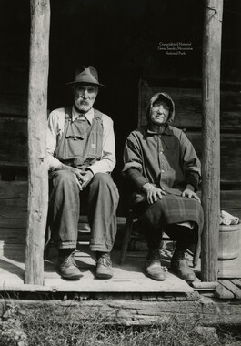
This 123-acre tract 214 in Cataloochee was owned by Eldredge Caldwell. The Caldwell House in Big Cataloochee is among the few preserved structures that remain today. The house was built between 1898 and 1903 by Hiram Caldwell. The Caldwell Barn, adjacent to the house, was built in 1923. While, in general, the Great Smoky Mountains region was sparsely populated, the Cataloochee Valley remained an exception. By 1900, the population of Cataloochee had grown to 1,000 residents living in hundreds of log and frame homes. A few historic buildings have been preserved on site, including two churches, a school, several homes, and outbuildings. The North Carolina Park Commission was tasked with purchasing land for the Great Smoky Mountains National Park and people living in Cataloochee were among those displaced. Cataloochee families continue to return for annual reunions. In 2001, the National Park Service re-introduced elk into the valley.
-


Part of Collection
Great Smoky Mountains - A Park for America