- Canton Champion Fibre Company (2308)
- Cherokee Traditions (291)
- Civil War in Southern Appalachia (165)
- Craft Revival (1942)
- George Masa Collection (137)
- Great Smoky Mountains - A Park for America (2900)
- Highlights from Western Carolina University (422)
- Horace Kephart (941)
- Journeys Through Jackson (159)
- LGBTQIA+ Archive of Jackson County (85)
- Oral Histories of Western North Carolina (314)
- Picturing Appalachia (6797)
- Stories of Mountain Folk (413)
- Travel Western North Carolina (153)
- Western Carolina University Fine Art Museum Vitreograph Collection (129)
- Western Carolina University Herbarium (92)
- Western Carolina University: Making Memories (738)
- Western Carolina University Publications (2491)
- Western Carolina University Restricted Electronic Theses and Dissertations (146)
- Western North Carolina Regional Maps (71)
- World War II in Southern Appalachia (131)
- Allanstand Cottage Industries (62)
- Appalachian National Park Association (53)
- Bennett, Kelly, 1890-1974 (1463)
- Berry, Walter (76)
- Brasstown Carvers (40)
- Carver, George Washington, 1864?-1943 (26)
- Cathey, Joseph, 1803-1874 (1)
- Champion Fibre Company (233)
- Champion Paper and Fibre Company (297)
- Cherokee Indian Fair Association (16)
- Cherokee Language Program (22)
- Crowe, Amanda (40)
- Edmonston, Thomas Benton, 1842-1907 (7)
- Ensley, A. L. (Abraham Lincoln), 1865-1948 (275)
- Fromer, Irving Rhodes, 1913-1994 (70)
- George Butz (BFS 1907) (46)
- Goodrich, Frances Louisa (120)
- Grant, George Alexander, 1891-1964 (96)
- Heard, Marian Gladys (60)
- Kephart, Calvin, 1883-1969 (15)
- Kephart, Horace, 1862-1931 (313)
- Kephart, Laura, 1862-1954 (39)
- Laney, Gideon Thomas, 1889-1976 (439)
- Masa, George, 1881-1933 (61)
- McElhinney, William Julian, 1896-1953 (44)
- Niggli, Josephina, 1910-1983 (10)
- North Carolina Park Commission (105)
- Osborne, Kezia Stradley (9)
- Owens, Samuel Robert, 1918-1995 (11)
- Penland Weavers and Potters (36)
- Roberts, Vivienne (15)
- Roth, Albert, 1890-1974 (142)
- Schenck, Carl Alwin, 1868-1955 (1)
- Sherrill's Photography Studio (2565)
- Southern Highland Handicraft Guild (127)
- Southern Highlanders, Inc. (71)
- Stalcup, Jesse Bryson (46)
- Stearns, I. K. (213)
- Thompson, James Edward, 1880-1976 (226)
- United States. Indian Arts and Crafts Board (130)
- USFS (683)
- Vance, Zebulon Baird, 1830-1894 (1)
- Weaver, Zebulon, 1872-1948 (58)
- Western Carolina College (230)
- Western Carolina Teachers College (282)
- Western Carolina University (2008)
- Western Carolina University. Mountain Heritage Center (18)
- Whitman, Walt, 1819-1892 (10)
- Wilburn, Hiram Coleman, 1880-1967 (73)
- Williams, Isadora (3)
- Cain, Doreyl Ammons (0)
- Crittenden, Lorraine (0)
- Rhodes, Judy (0)
- Smith, Edward Clark (0)
- Appalachian Region, Southern (2929)
- Asheville (N.C.) (1944)
- Avery County (N.C.) (26)
- Blount County (Tenn.) (195)
- Buncombe County (N.C.) (1680)
- Cherokee County (N.C.) (283)
- Clay County (N.C.) (556)
- Graham County (N.C.) (238)
- Great Smoky Mountains National Park (N.C. and Tenn.) (525)
- Haywood County (N.C.) (3571)
- Henderson County (N.C.) (70)
- Jackson County (N.C.) (4917)
- Knox County (Tenn.) (35)
- Knoxville (Tenn.) (13)
- Lake Santeetlah (N.C.) (10)
- Macon County (N.C.) (420)
- Madison County (N.C.) (216)
- McDowell County (N.C.) (39)
- Mitchell County (N.C.) (135)
- Polk County (N.C.) (35)
- Qualla Boundary (982)
- Rutherford County (N.C.) (78)
- Swain County (N.C.) (2185)
- Transylvania County (N.C.) (270)
- Watauga County (N.C.) (12)
- Waynesville (N.C.) (86)
- Yancey County (N.C.) (72)
- Aerial Photographs (3)
- Aerial Views (60)
- Albums (books) (4)
- Articles (1)
- Artifacts (object Genre) (228)
- Bibliographies (1)
- Biography (general Genre) (2)
- Cards (information Artifacts) (38)
- Clippings (information Artifacts) (191)
- Copybooks (instructional Materials) (3)
- Crafts (art Genres) (622)
- Depictions (visual Works) (21)
- Design Drawings (1)
- Drawings (visual Works) (185)
- Envelopes (73)
- Exhibitions (events) (1)
- Facsimiles (reproductions) (1)
- Fiction (general Genre) (4)
- Financial Records (12)
- Fliers (printed Matter) (67)
- Glass Plate Negatives (381)
- Guidebooks (2)
- Internegatives (10)
- Interviews (815)
- Land Surveys (102)
- Letters (correspondence) (1013)
- Manuscripts (documents) (618)
- Maps (documents) (177)
- Memorandums (25)
- Minutes (administrative Records) (59)
- Negatives (photographs) (6090)
- Newsletters (1290)
- Newspapers (2)
- Notebooks (8)
- Occupation Currency (1)
- Paintings (visual Works) (1)
- Pen And Ink Drawings (1)
- Periodicals (193)
- Personal Narratives (10)
- Photographs (12976)
- Plans (maps) (1)
- Poetry (5)
- Portraits (4568)
- Postcards (329)
- Programs (documents) (181)
- Publications (documents) (2443)
- Questionnaires (65)
- Relief Prints (26)
- Sayings (literary Genre) (1)
- Scrapbooks (282)
- Sheet Music (2)
- Slides (photographs) (402)
- Songs (musical Compositions) (2)
- Sound Recordings (796)
- Specimens (92)
- Speeches (documents) (18)
- Tintypes (photographs) (8)
- Transcripts (322)
- Video Recordings (physical Artifacts) (23)
- Text Messages (0)
- A.L. Ensley Collection (275)
- Appalachian Industrial School Records (7)
- Appalachian National Park Association Records (336)
- Axley-Meroney Collection (2)
- Bayard Wootten Photograph Collection (20)
- Bethel Rural Community Organization Collection (7)
- Blumer Collection (5)
- C.W. Slagle Collection (20)
- Canton Area Historical Museum (2110)
- Carlos C. Campbell Collection (462)
- Cataloochee History Project (64)
- Cherokee Studies Collection (4)
- Daisy Dame Photograph Album (5)
- Daniel Boone VI Collection (1)
- Doris Ulmann Photograph Collection (112)
- Elizabeth H. Lasley Collection (1)
- Elizabeth Woolworth Szold Fleharty Collection (4)
- Frank Fry Collection (95)
- George Masa Collection (173)
- Gideon Laney Collection (452)
- Hazel Scarborough Collection (2)
- Hiram C. Wilburn Papers (28)
- Historic Photographs Collection (236)
- Horace Kephart Collection (861)
- Humbard Collection (33)
- Hunter and Weaver Families Collection (1)
- I. D. Blumenthal Collection (4)
- Isadora Williams Collection (4)
- Jesse Bryson Stalcup Collection (47)
- Jim Thompson Collection (224)
- John B. Battle Collection (7)
- John C. Campbell Folk School Records (80)
- John Parris Collection (6)
- Judaculla Rock project (2)
- Kelly Bennett Collection (1482)
- Love Family Papers (11)
- Major Wiley Parris Civil War Letters (3)
- Map Collection (12)
- McFee-Misemer Civil War Letters (34)
- Mountain Heritage Center Collection (4)
- Norburn - Robertson - Thomson Families Collection (44)
- Pauline Hood Collection (7)
- Pre-Guild Collection (2)
- Qualla Arts and Crafts Mutual Collection (12)
- R.A. Romanes Collection (681)
- Rosser H. Taylor Collection (1)
- Samuel Robert Owens Collection (94)
- Sara Madison Collection (144)
- Sherrill Studio Photo Collection (2558)
- Smoky Mountains Hiking Club Collection (616)
- Stories of Mountain Folk - Radio Programs (374)
- The Reporter, Western Carolina University (510)
- Venoy and Elizabeth Reed Collection (16)
- WCU Gender and Sexuality Oral History Project (32)
- WCU Mountain Heritage Center Oral Histories (25)
- WCU Oral History Collection - Mountain People, Mountain Lives (71)
- WCU Students Newspapers Collection (1923)
- Western North Carolina Tomorrow Black Oral History Project (69)
- William Williams Stringfield Collection (2)
- Zebulon Weaver Collection (109)
- African Americans (390)
- Appalachian Trail (35)
- Artisans (521)
- Cherokee art (84)
- Cherokee artists -- North Carolina (10)
- Cherokee language (21)
- Cherokee pottery (101)
- Cherokee women (208)
- Church buildings (190)
- Civilian Conservation Corps (U.S.) (111)
- College student newspapers and periodicals (2012)
- Dams (108)
- Dance (1023)
- Education (222)
- Floods (61)
- Folk music (1015)
- Forced removal, 1813-1903 (2)
- Forest conservation (220)
- Forests and forestry (1196)
- Gender nonconformity (4)
- Great Smoky Mountains National Park (N.C. and Tenn.) (181)
- Hunting (46)
- Landscape photography (25)
- Logging (119)
- Maps (83)
- Mines and mineral resources (9)
- North Carolina -- Maps (18)
- Paper industry (38)
- Postcards (255)
- Pottery (135)
- Railroad trains (72)
- Rural electrification -- North Carolina, Western (3)
- School integration -- Southern States (2)
- Segregation -- North Carolina, Western (5)
- Slavery (5)
- Sports (452)
- Storytelling (243)
- Waterfalls -- Great Smoky Mountains (N.C. and Tenn.) (66)
- Weaving -- Appalachian Region, Southern (280)
- Wood-carving -- Appalachian Region, Southern (328)
- World War, 1939-1945 (173)
Handbook/ 1933/ Smoky Mountains Hiking Club
Handbook/ 1933/ Smoky Mountains Hiking Club
GSMNP_13150_54_01_1148_01
Handbook/ 1933/ Smoky Mountains Hiking Club
GSMNP_13150_54_01_1148_02
Handbook/ 1933/ Smoky Mountains Hiking Club
GSMNP_13150_54_01_1148_03
Handbook/ 1933/ Smoky Mountains Hiking Club
GSMNP_13150_54_01_1148_04
Handbook/ 1933/ Smoky Mountains Hiking Club
GSMNP_13150_54_01_1148_05
Handbook/ 1933/ Smoky Mountains Hiking Club
GSMNP_13150_54_01_1148_06
Handbook/ 1933/ Smoky Mountains Hiking Club
GSMNP_13150_54_01_1148_07
Handbook/ 1933/ Smoky Mountains Hiking Club
GSMNP_13150_54_01_1148_08
Handbook/ 1933/ Smoky Mountains Hiking Club
GSMNP_13150_54_01_1148_09
Handbook/ 1933/ Smoky Mountains Hiking Club
GSMNP_13150_54_01_1148_10
Handbook/ 1933/ Smoky Mountains Hiking Club
GSMNP_13150_54_01_1148_11
Handbook/ 1933/ Smoky Mountains Hiking Club
GSMNP_13150_54_01_1148_12
Handbook/ 1933/ Smoky Mountains Hiking Club
GSMNP_13150_54_01_1148_13
Handbook/ 1933/ Smoky Mountains Hiking Club
GSMNP_13150_54_01_1148_14
Handbook/ 1933/ Smoky Mountains Hiking Club
GSMNP_13150_54_01_1148_15
Handbook/ 1933/ Smoky Mountains Hiking Club
GSMNP_13150_54_01_1148_16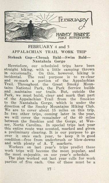
Handbook/ 1933/ Smoky Mountains Hiking Club
GSMNP_13150_54_01_1148_17
Handbook/ 1933/ Smoky Mountains Hiking Club
GSMNP_13150_54_01_1148_18
Handbook/ 1933/ Smoky Mountains Hiking Club
GSMNP_13150_54_01_1148_19
Handbook/ 1933/ Smoky Mountains Hiking Club
GSMNP_13150_54_01_1148_20
Handbook/ 1933/ Smoky Mountains Hiking Club
GSMNP_13150_54_01_1148_21
Handbook/ 1933/ Smoky Mountains Hiking Club
GSMNP_13150_54_01_1148_22
Handbook/ 1933/ Smoky Mountains Hiking Club
GSMNP_13150_54_01_1148_23
Handbook/ 1933/ Smoky Mountains Hiking Club
GSMNP_13150_54_01_1148_24
Handbook/ 1933/ Smoky Mountains Hiking Club
GSMNP_13150_54_01_1148_25
Handbook/ 1933/ Smoky Mountains Hiking Club
GSMNP_13150_54_01_1148_26
Handbook/ 1933/ Smoky Mountains Hiking Club
GSMNP_13150_54_01_1148_27
Handbook/ 1933/ Smoky Mountains Hiking Club
GSMNP_13150_54_01_1148_28
Handbook/ 1933/ Smoky Mountains Hiking Club
GSMNP_13150_54_01_1148_29
Handbook/ 1933/ Smoky Mountains Hiking Club
GSMNP_13150_54_01_1148_30
Handbook/ 1933/ Smoky Mountains Hiking Club
GSMNP_13150_54_01_1148_31
Handbook/ 1933/ Smoky Mountains Hiking Club
GSMNP_13150_54_01_1148_32
Handbook/ 1933/ Smoky Mountains Hiking Club
GSMNP_13150_54_01_1148_33
Handbook/ 1933/ Smoky Mountains Hiking Club
GSMNP_13150_54_01_1148_34
Handbook/ 1933/ Smoky Mountains Hiking Club
GSMNP_13150_54_01_1148_35
Handbook/ 1933/ Smoky Mountains Hiking Club
GSMNP_13150_54_01_1148_36
Handbook/ 1933/ Smoky Mountains Hiking Club
GSMNP_13150_54_01_1148_37
Handbook/ 1933/ Smoky Mountains Hiking Club
GSMNP_13150_54_01_1148_38
Handbook/ 1933/ Smoky Mountains Hiking Club
GSMNP_13150_54_01_1148_39
Handbook/ 1933/ Smoky Mountains Hiking Club
GSMNP_13150_54_01_1148_40
Handbook/ 1933/ Smoky Mountains Hiking Club
GSMNP_13150_54_01_1148_41
Handbook/ 1933/ Smoky Mountains Hiking Club
GSMNP_13150_54_01_1148_42
Handbook/ 1933/ Smoky Mountains Hiking Club
GSMNP_13150_54_01_1148_43
Handbook/ 1933/ Smoky Mountains Hiking Club
GSMNP_13150_54_01_1148_44
Handbook/ 1933/ Smoky Mountains Hiking Club
GSMNP_13150_54_01_1148_45
Handbook/ 1933/ Smoky Mountains Hiking Club
GSMNP_13150_54_01_1148_46
Handbook/ 1933/ Smoky Mountains Hiking Club
GSMNP_13150_54_01_1148_47
Handbook/ 1933/ Smoky Mountains Hiking Club
GSMNP_13150_54_01_1148_48
Handbook/ 1933/ Smoky Mountains Hiking Club
GSMNP_13150_54_01_1148_49
Handbook/ 1933/ Smoky Mountains Hiking Club
GSMNP_13150_54_01_1148_50
Handbook/ 1933/ Smoky Mountains Hiking Club
GSMNP_13150_54_01_1148_51
Handbook/ 1933/ Smoky Mountains Hiking Club
GSMNP_13150_54_01_1148_52
Handbook/ 1933/ Smoky Mountains Hiking Club
GSMNP_13150_54_01_1148_53
Handbook/ 1933/ Smoky Mountains Hiking Club
GSMNP_13150_54_01_1148_54
Handbook/ 1933/ Smoky Mountains Hiking Club
GSMNP_13150_54_01_1148_55
Handbook/ 1933/ Smoky Mountains Hiking Club
GSMNP_13150_54_01_1148_56
Handbook/ 1933/ Smoky Mountains Hiking Club
GSMNP_13150_54_01_1148_57
Handbook/ 1933/ Smoky Mountains Hiking Club
GSMNP_13150_54_01_1148_58
Handbook/ 1933/ Smoky Mountains Hiking Club
GSMNP_13150_54_01_1148_59
Handbook/ 1933/ Smoky Mountains Hiking Club
GSMNP_13150_54_01_1148_60
Handbook/ 1933/ Smoky Mountains Hiking Club
GSMNP_13150_54_01_1148_61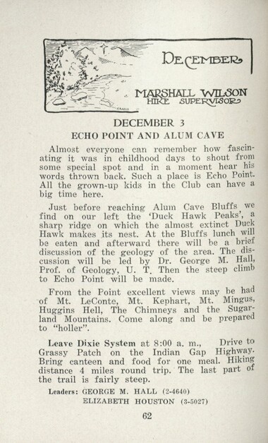
Handbook/ 1933/ Smoky Mountains Hiking Club
GSMNP_13150_54_01_1148_62
Handbook/ 1933/ Smoky Mountains Hiking Club
GSMNP_13150_54_01_1148_63
Handbook/ 1933/ Smoky Mountains Hiking Club
GSMNP_13150_54_01_1148_64
Handbook/ 1933/ Smoky Mountains Hiking Club
GSMNP_13150_54_01_1148_65
Handbook/ 1933/ Smoky Mountains Hiking Club
GSMNP_13150_54_01_1148_66
Handbook/ 1933/ Smoky Mountains Hiking Club
GSMNP_13150_54_01_1148_67
Handbook/ 1933/ Smoky Mountains Hiking Club
GSMNP_13150_54_01_1148_68
Handbook/ 1933/ Smoky Mountains Hiking Club
GSMNP_13150_54_01_1148_69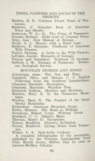
Handbook/ 1933/ Smoky Mountains Hiking Club
GSMNP_13150_54_01_1148_70
Handbook/ 1933/ Smoky Mountains Hiking Club
GSMNP_13150_54_01_1148_71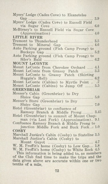
Handbook/ 1933/ Smoky Mountains Hiking Club
GSMNP_13150_54_01_1148_72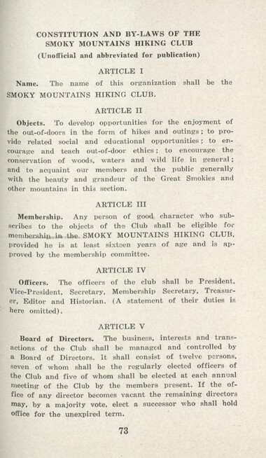
Handbook/ 1933/ Smoky Mountains Hiking Club
GSMNP_13150_54_01_1148_73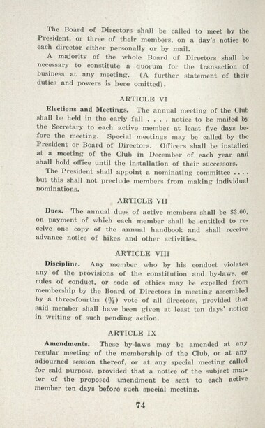
Handbook/ 1933/ Smoky Mountains Hiking Club
GSMNP_13150_54_01_1148_74
Handbook/ 1933/ Smoky Mountains Hiking Club
GSMNP_13150_54_01_1148_75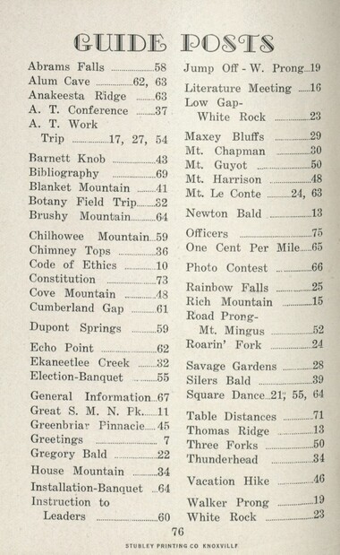
Handbook/ 1933/ Smoky Mountains Hiking Club
GSMNP_13150_54_01_1148_76
Handbook/ 1933/ Smoky Mountains Hiking Club
GSMNP_13150_54_01_1148_77
Handbook/ 1933/ Smoky Mountains Hiking Club
GSMNP_13150_54_01_1148_78Item’s are ‘child’ level descriptions to ‘parent’ objects, (e.g. one page of a whole book).
-
-
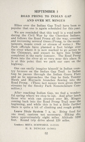
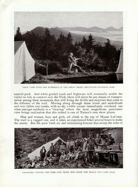
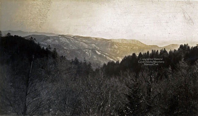
SEPTEMBER 3 ROAD PRONG TO INDIAN GAP AND OVER MT. MINGUS Hikes over the Indian Gap Trail have been so popular that one is again scheduled for this year. We are reminded that this trail is a road made during the Civil War by the Cherokee Indians, and follows the Road Prong all the way, crossing and recrossing several times.(Prong, to the mountaineers, means creek or stream of water.) The Park officials have planned a foot bridge over the river where it is now marked to go across to the Chimneys, and expect to have this bridge completed in the early summer. The Road Prong flows into the river at or very near this place. It is at this point that we park our cars on the highway. One can easily imagine himself in Indian country because on the Indian Gap Trail to Indian Gap he passes through the Indian Grave Flats and as he approaches the Gap he finds Tommy Hawk and Moccasin branches flowing into the Road Prong. (These last names were given these streams by the Smoky Park Nomenclature Committee. ) After reaching Indian Gap, we find a wonderful spring where we stop to eat. And after lunch those who wish can proceed over Mt. Mingus coming back into the Road Prong Trail near the beginning, and while this is but a little further there is quite a bit of climbing and rough going- Leave Dixie System 7 a. m. Bring food for one meal, canteen not necessary. Hiking distance approximately eight miles. Altitude 526b feet. Round trip drive about 120 miles. Leaders: META SCHWOEGL (2-2153) H. R. DUNCAN (3-7681) 52
Object’s are ‘parent’ level descriptions to ‘children’ items, (e.g. a book with pages).
-
In 1926, the Smoky Mountains Hiking Club began to print an annual handbook that outlined scheduled hikes for each month of the year, including winter. This 1933 handbook was collected by George Masa (1881-1933), a photographer active in the Appalachian Trail Club and in the movement to establish the Great Smoky Mountains National Park. The Smoky Mountains Hiking Club was formed after a group of outdoor enthusiasts hiked up to Mount LeConte in October 1924. Enjoying the spectacular views, the group returned to establish a formal hiking club to sponsor regularly-scheduled hikes into the Great Smoky Mountains.
-
Related items
-
Western Carolinian Volume 24 Number 05
-
Western Carolinian Volume 70 Number 11

-
Western Carolinian Volume 66 (67) Number 08 (13)
-
Cherokee Indian Fair 1935

-
Western Carolinian 1979 Fall Special Edition
-
Western Carolinian Volume 70 Number 13

-
National Park in the Great Smoky Mountains
-
Western Carolinian Volume 59 Number 14 (15)

-
Western Carolinian Volume 47 Number 18
-
Western Carolinian Volume 63 Number 06
-
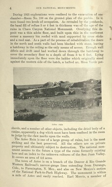
Glimpses of our National Monuments
-
Western Carolinian Volume 78 Number 15

-
Western Carolinian Volume 69 Number 08

-
Western Carolinian Volume 66 (67) Number 11

-
Western Carolinian Volume 28 Number 05
-
Western Carolinian Volume 36 Number 17
-
Western Carolinian Volume 65 (66) Number 02

-
Western Carolinian Volume 44 Number 28

-
Western Carolinian Volume 55 Number 07
-
Champion Owns the Trees!

-
Western Carolinian Volume 67 Number 01
-
Western Carolinian Volume 67 Number 07
-
Ferns of the Great Smoky Mountains National Park
-
Western Carolinian Volume 55 Number 07

-
Western Carolinian Volume 67 Number 04

-
Western Carolinian Volume 02 Number 03
-
Western Carolinian Volume 50 (51) Number 08

-
Western Carolinian Volume 75 Number 08
-
Western Carolinian Volume 03 Number 08
-
Western Carolinian Volume 40 Number 11
-
Western Carolinian Volume 52 Number 07

-
Western Carolinian Volume 76 Number 07
Part of Collection
Great Smoky Mountains - A Park for America
-
Handbook/ 1932/ Smoky Mountains Hiking Club

-
LeConte Creek

-
Requests for information on Appalachian National Park
-
Marshall Wilson, Harvey Broome, and Lucien Green at their camp
-
Cataloochee tract 292: J. L. C. Messer
-
Inventory of Horace Kephart collection
-
Handbook/ 1931/ Smoky Mountains Hiking Club

-
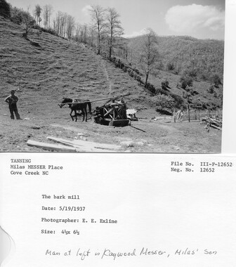
Cataloochee Cove Creek - Milas Messer
-
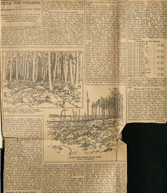
Reasons in Favor of the Establishment of a National Park
-
Legislation on behalf of the Appalachian National Park

-
Unaka and the Pisgah
-
Requests for information on Appalachian National Park

-
Memories of District C: Civilian Conservation Corps
-
Great Smoky Mountains National Park / Land of the Everlasting Hills
-
Cataloochee tract 244: John M. Palmer
-
Cataloochee tract 231: W. G. B. Messer
-
Civilian Conservation Corps Annual: District "C"

-
Logging: saw pit on Saluda Mountain

-
Subscriptions received by the Appalachian National Park Association
-
Report of the Secretary of Agriculture in relation to the forests, rivers, and mountains of the southern Appalachian region

-
Interviews by Joe Hall about life in Cataloochee

-
Handbook/ 1932/ Smoky Mountains Hiking Club

-
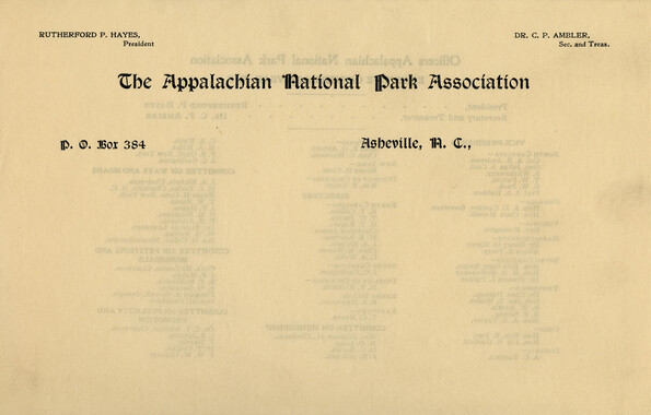
Letterhead, Appalachian National Park Association
-
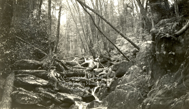
Hikers on Chapman Creek
-
Correspondence: Zebulon Weaver to Mrs. W. E. Comstock, September 4, 1933

-
Correspondence regarding 1901 meeting

-
Scrapbook by A. H. McQuilkin
-
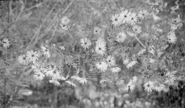
New England Asters
-
North Carolina from Indian Gap
-
Minutes of Meetings of the Appalachian National Park Association
-
Appalachian Trail Club bulletin
-
Activities of the Appalachian National Park Association and the Appalachian National Forest Reserve Association: 1899-1906