- Canton Champion Fibre Company (2308)
- Cherokee Traditions (293)
- Civil War in Southern Appalachia (165)
- Craft Revival (1942)
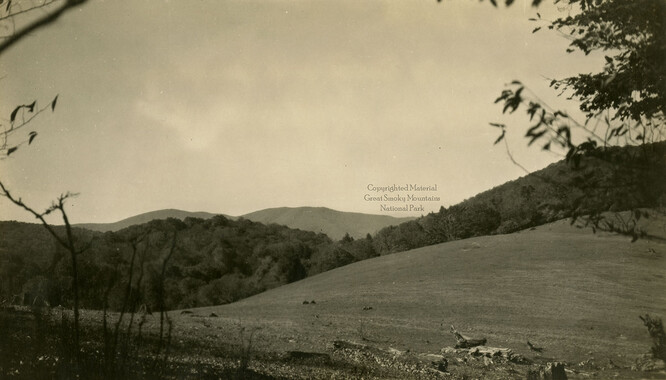
- Great Smoky Mountains - A Park for America (2767)
- Highlights from Western Carolina University (430)
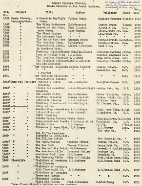
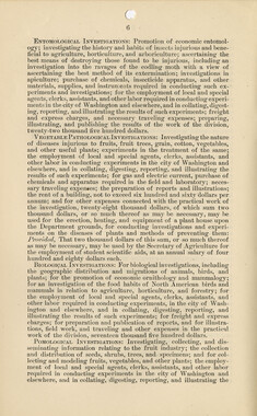
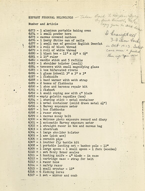
- Horace Kephart (941)
- Journeys Through Jackson (154)
- LGBTQIA+ Archive of Jackson County (24)
- Oral Histories of Western North Carolina (314)
- Picturing Appalachia (6772)
- Stories of Mountain Folk (413)
- Travel Western North Carolina (160)
- Western Carolina University Fine Art Museum Vitreograph Collection (129)
- Western Carolina University Herbarium (92)
- Western Carolina University: Making Memories (708)
- Western Carolina University Publications (2283)
- Western Carolina University Restricted Electronic Theses and Dissertations (146)
- Western North Carolina Regional Maps (71)
- World War II in Southern Appalachia (131)
- Allanstand Cottage Industries (62)
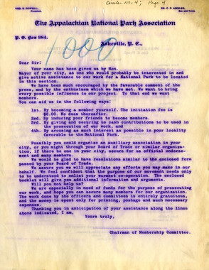
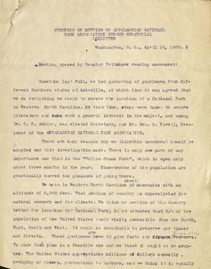
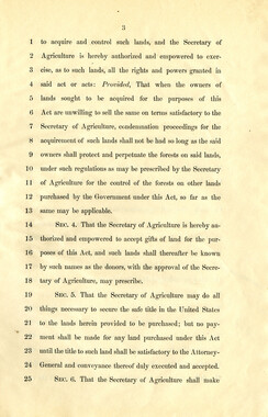
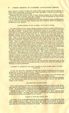
- Appalachian National Park Association (53)
- Bennett, Kelly, 1890-1974 (1388)
- Berry, Walter (76)
- Brasstown Carvers (40)
- Carver, George Washington, 1864?-1943 (26)
- Cathey, Joseph, 1803-1874 (1)
- Champion Fibre Company (233)
- Champion Paper and Fibre Company (297)
- Cherokee Indian Fair Association (16)
- Cherokee Language Program (22)
- Crowe, Amanda (40)
- Edmonston, Thomas Benton, 1842-1907 (7)
- Ensley, A. L. (Abraham Lincoln), 1865-1948 (275)
- Fromer, Irving Rhodes, 1913-1994 (70)
- George Butz (BFS 1907) (46)
- Goodrich, Frances Louisa (120)
- Grant, George Alexander, 1891-1964 (96)
- Heard, Marian Gladys (60)
- Kephart, Calvin, 1883-1969 (15)
- Kephart, Horace, 1862-1931 (313)
- Kephart, Laura, 1862-1954 (39)
- Laney, Gideon Thomas, 1889-1976 (439)
- Masa, George, 1881-1933 (61)
- McElhinney, William Julian, 1896-1953 (44)
- Niggli, Josephina, 1910-1983 (10)
- North Carolina Park Commission (105)
- Osborne, Kezia Stradley (9)
- Owens, Samuel Robert, 1918-1995 (11)
- Penland Weavers and Potters (36)
- Roberts, Vivienne (15)
- Roth, Albert, 1890-1974 (142)
- Schenck, Carl Alwin, 1868-1955 (1)
- Sherrill's Photography Studio (2565)
- Southern Highland Handicraft Guild (127)
- Southern Highlanders, Inc. (71)
- Stalcup, Jesse Bryson (46)
- Stearns, I. K. (213)
- Thompson, James Edward, 1880-1976 (226)
- United States. Indian Arts and Crafts Board (130)
- USFS (683)
- Vance, Zebulon Baird, 1830-1894 (1)
- Weaver, Zebulon, 1872-1948 (58)
- Western Carolina College (230)
- Western Carolina Teachers College (282)
- Western Carolina University (1794)
- Western Carolina University. Mountain Heritage Center (18)
- Whitman, Walt, 1819-1892 (10)
- Wilburn, Hiram Coleman, 1880-1967 (73)
- Williams, Isadora (3)
- Cain, Doreyl Ammons (0)
- Crittenden, Lorraine (0)
- Rhodes, Judy (0)
- Smith, Edward Clark (0)
- Appalachian Region, Southern (2393)
- Asheville (N.C.) (1887)
- Avery County (N.C.) (26)
- Blount County (Tenn.) (161)
- Buncombe County (N.C.) (1664)
- Cherokee County (N.C.) (283)
- Clay County (N.C.) (555)
- Graham County (N.C.) (233)
- Great Smoky Mountains National Park (N.C. and Tenn.) (478)
- Haywood County (N.C.) (3522)
- Henderson County (N.C.) (70)
- Jackson County (N.C.) (4692)
- Knox County (Tenn.) (25)
- Knoxville (Tenn.) (12)
- Lake Santeetlah (N.C.) (10)
- Macon County (N.C.) (420)
- Madison County (N.C.) (211)
- McDowell County (N.C.) (39)
- Mitchell County (N.C.) (132)
- Polk County (N.C.) (35)
- Qualla Boundary (981)
- Rutherford County (N.C.) (76)
- Swain County (N.C.) (2113)
- Transylvania County (N.C.) (247)
- Watauga County (N.C.) (12)
- Waynesville (N.C.) (68)
- Yancey County (N.C.) (72)
- Aerial Photographs (3)
- Aerial Views (60)
- Albums (books) (4)
- Articles (1)
- Artifacts (object Genre) (228)
- Biography (general Genre) (2)
- Cards (information Artifacts) (38)
- Clippings (information Artifacts) (191)
- Crafts (art Genres) (622)
- Depictions (visual Works) (21)
- Design Drawings (1)
- Drawings (visual Works) (184)
- Envelopes (73)
- Facsimiles (reproductions) (1)
- Fiction (general Genre) (4)
- Financial Records (12)
- Fliers (printed Matter) (67)
- Glass Plate Negatives (381)
- Guidebooks (2)
- Internegatives (10)
- Interviews (811)
- Land Surveys (102)
- Letters (correspondence) (1013)
- Manuscripts (documents) (619)
- Maps (documents) (159)
- Memorandums (25)
- Minutes (administrative Records) (59)
- Negatives (photographs) (5835)
- Newsletters (1285)
- Newspapers (2)
- Occupation Currency (1)
- Paintings (visual Works) (1)
- Pen And Ink Drawings (1)
- Periodicals (193)
- Personal Narratives (7)
- Photographs (12975)
- Plans (maps) (1)
- Poetry (6)
- Portraits (1663)
- Postcards (329)
- Programs (documents) (151)
- Publications (documents) (2237)
- Questionnaires (65)
- Scrapbooks (282)
- Sheet Music (1)
- Slides (photographs) (402)
- Sound Recordings (796)
- Specimens (92)
- Speeches (documents) (15)
- Tintypes (photographs) (8)
- Transcripts (322)
- Video Recordings (physical Artifacts) (23)
- Vitreographs (129)
- Text Messages (0)
- A.L. Ensley Collection (275)
- Appalachian Industrial School Records (7)
- Appalachian National Park Association Records (336)
- Axley-Meroney Collection (2)
- Bayard Wootten Photograph Collection (20)
- Bethel Rural Community Organization Collection (7)
- Blumer Collection (5)
- C.W. Slagle Collection (20)
- Canton Area Historical Museum (2110)
- Carlos C. Campbell Collection (282)
- Cataloochee History Project (65)
- Cherokee Studies Collection (4)
- Daisy Dame Photograph Album (5)
- Daniel Boone VI Collection (1)
- Doris Ulmann Photograph Collection (112)
- Elizabeth H. Lasley Collection (1)
- Elizabeth Woolworth Szold Fleharty Collection (4)
- Frank Fry Collection (95)
- George Masa Collection (173)
- Gideon Laney Collection (452)
- Hazel Scarborough Collection (2)
- Hiram C. Wilburn Papers (28)
- Historic Photographs Collection (236)
- Horace Kephart Collection (861)
- Humbard Collection (33)
- Hunter and Weaver Families Collection (1)
- I. D. Blumenthal Collection (4)
- Isadora Williams Collection (4)
- Jesse Bryson Stalcup Collection (47)
- Jim Thompson Collection (224)
- John B. Battle Collection (7)
- John C. Campbell Folk School Records (80)
- John Parris Collection (6)
- Judaculla Rock project (2)
- Kelly Bennett Collection (1407)
- Love Family Papers (11)
- Major Wiley Parris Civil War Letters (3)
- Map Collection (12)
- McFee-Misemer Civil War Letters (34)
- Mountain Heritage Center Collection (4)
- Norburn - Robertson - Thomson Families Collection (44)
- Pauline Hood Collection (7)
- Pre-Guild Collection (2)
- Qualla Arts and Crafts Mutual Collection (12)
- R.A. Romanes Collection (681)
- Rosser H. Taylor Collection (1)
- Samuel Robert Owens Collection (94)
- Sara Madison Collection (144)
- Sherrill Studio Photo Collection (2558)
- Smoky Mountains Hiking Club Collection (616)
- Stories of Mountain Folk - Radio Programs (374)
- The Reporter, Western Carolina University (510)
- Venoy and Elizabeth Reed Collection (16)
- WCU Gender and Sexuality Oral History Project (32)
- WCU Mountain Heritage Center Oral Histories (25)
- WCU Oral History Collection - Mountain People, Mountain Lives (71)
- WCU Students Newspapers Collection (1744)
- Western North Carolina Tomorrow Black Oral History Project (69)
- William Williams Stringfield Collection (2)
- Zebulon Weaver Collection (109)
- African Americans (390)
- Appalachian Trail (35)
- Artisans (521)
- Cherokee art (84)
- Cherokee artists -- North Carolina (10)
- Cherokee language (21)
- Cherokee pottery (101)
- Cherokee women (208)
- Church buildings (167)
- Civilian Conservation Corps (U.S.) (110)
- College student newspapers and periodicals (1830)
- Dams (103)
- Dance (1023)
- Education (222)
- Floods (61)
- Folk music (1015)
- Forced removal, 1813-1903 (2)
- Forest conservation (220)
- Forests and forestry (917)
- Gender nonconformity (4)
- Great Smoky Mountains National Park (N.C. and Tenn.) (154)
- Hunting (38)
- Landscape photography (10)
- Logging (103)
- Maps (84)
- Mines and mineral resources (8)
- North Carolina -- Maps (18)
- Paper industry (38)
- Postcards (255)
- Pottery (135)
- Railroad trains (71)
- Rural electrification -- North Carolina, Western (3)
- School integration -- Southern States (2)
- Segregation -- North Carolina, Western (5)
- Slavery (5)
- Sports (452)
- Storytelling (245)
- Waterfalls -- Great Smoky Mountains (N.C. and Tenn.) (66)
- Weaving -- Appalachian Region, Southern (280)
- Wood-carving -- Appalachian Region, Southern (328)
- World War, 1939-1945 (173)
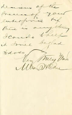
Federal court records, Belding et al. v. Hebard: Slick Rock Creek area
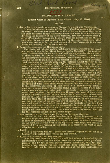
Federal court records, Belding et al. v. Hebard: Slick Rock Creek area
GSMNP_13150_17_1131_01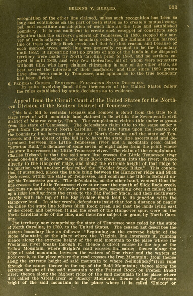
Federal court records, Belding et al. v. Hebard: Slick Rock Creek area
GSMNP_13150_17_1131_02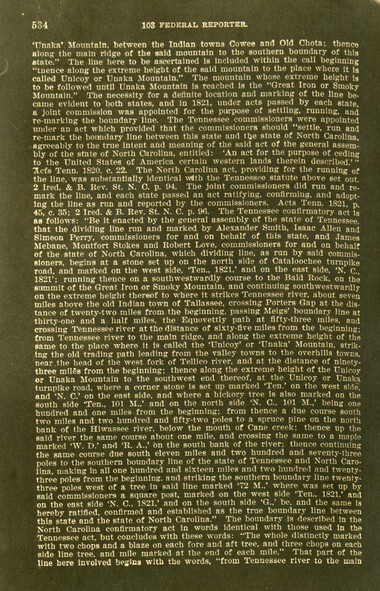
Federal court records, Belding et al. v. Hebard: Slick Rock Creek area
GSMNP_13150_17_1131_03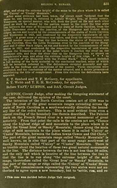
Federal court records, Belding et al. v. Hebard: Slick Rock Creek area
GSMNP_13150_17_1131_04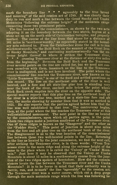
Federal court records, Belding et al. v. Hebard: Slick Rock Creek area
GSMNP_13150_17_1131_05
Federal court records, Belding et al. v. Hebard: Slick Rock Creek area
GSMNP_13150_17_1131_06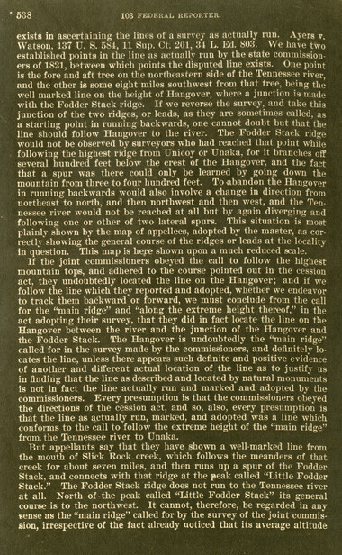
Federal court records, Belding et al. v. Hebard: Slick Rock Creek area
GSMNP_13150_17_1131_07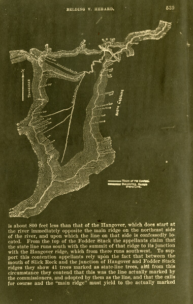
Federal court records, Belding et al. v. Hebard: Slick Rock Creek area
GSMNP_13150_17_1131_08
Federal court records, Belding et al. v. Hebard: Slick Rock Creek area
GSMNP_13150_17_1131_09
Federal court records, Belding et al. v. Hebard: Slick Rock Creek area
GSMNP_13150_17_1131_10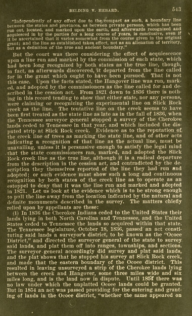
Federal court records, Belding et al. v. Hebard: Slick Rock Creek area
GSMNP_13150_17_1131_11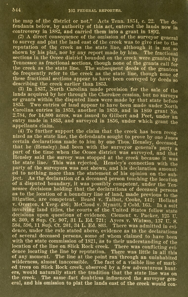
Federal court records, Belding et al. v. Hebard: Slick Rock Creek area
GSMNP_13150_17_1131_12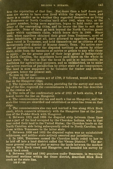
Federal court records, Belding et al. v. Hebard: Slick Rock Creek area
GSMNP_13150_17_1131_13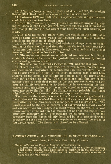
Federal court records, Belding et al. v. Hebard: Slick Rock Creek area
GSMNP_13150_17_1131_14Item’s are ‘child’ level descriptions to ‘parent’ objects, (e.g. one page of a whole book).
-
-
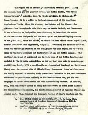
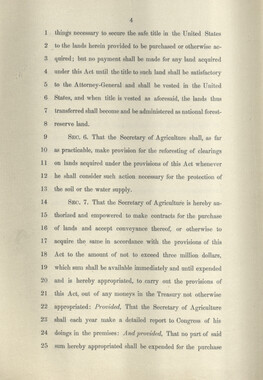
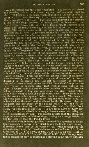
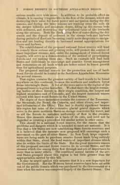
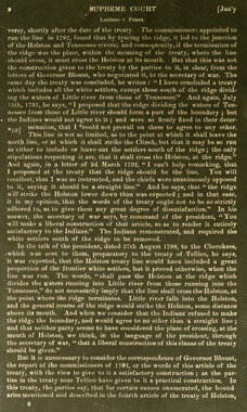
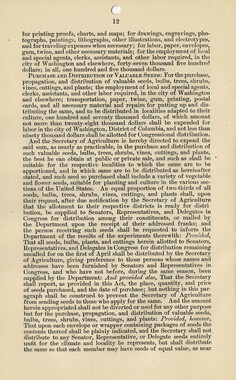
. ■ ■ \ ■ .■ .■ ■ .■ .. ■ ■ ■ ■ . ■ -■■ ... ■ ■ ■ - ■.. -.:■;■■ -. ■ . .■ : . ■ ■ - ■ ■ ■ - ■ .-■-.■■.., wmmm >;'e;> ' . ■■W-m mm tween the Smoky and the Unicoy Mountain. The cession act placed the boundary "along the extreme height of laid mountain (that is, the Great Smoky) to the place where it is called TJnicoy? or 'Unaka' Mountain." It was the duty of the commissioners to locate the line "agreeably" to this call. They bad been following the extreme height of the ridge between the Smoky and the Tennessee river. The river cul through the ridge by a deep gorge, the .mountain on either side gradually lowering, and terminating at the river in a bluff. The last monument on the northeastern side is a tree marked as a fore and aft tree. A fore and aft tree is a tree in the line, and the chops are on the sides showing the direction of the line. The chops OH this tree indicated that the line there crossed the river. The general course of the line, as called for by the call which brought the line to the river, was southwesterly, and this course was to be continued to the Unaka. The course would, therefore, require the line to there cross the river, as also indicated by the chops on the tree. The general direction of the cession act would keep the line on the extreme height of the mountain ridge or range. Immediately across the river, and in the general course of the line, was the Hangover ridge. This ridge is joined by another ridge called the "Fodder Stack," some eight or ten miles southwest. Its height increases after it leaves the river, and the highest points between the river and the junction with the Fodder Stack are the Hangover and Hao peaks, the former having an altitude of about 4,500 feet From the point where it is joined by the Fodder Stack ridge or spur, it is admittedly the main ridge, and further southwest becomes the Unicoy or Unaka. From the river the general course of Hangover is southwesterly, and therefore in the general course of the lint as described in the cession act. One-half mile below the state-line fore and aft tree, a creek known as "Slick Rock'Creek" empties into the river on the opposite side. That creek is some eight or ten miles in length, and has one or more branches. A short distance below its mouth a low spur approaches the river, called "Slick Rock Spur," being a spur of Fodder Stack ridge. Some seven miles up the creek another spur of Fodder Stack is found. The basin of the Slick Rock is about eight miles long and three miles wide. It is bounded on the south and southeast by the Hangover ridge, on the north and northwest by the Fodder Stack ridge, and on the north and northeast by the Tennessee river and the Slick Rock ridge. The mountains shutting it in are from 1,000 to 4,000 feet high, and the basin itself is a rough, broken mountain valley, almost impenetrable by man. The master reports that the Hangover ridge was the main or highest ridge, having an average height of 800 feet greater than the Fodder Stack. It is admissible, in locating a line, where a difficulty exists in identifying monuments, natural or artificial, to run the line in a reverse way, if thereby doubts may be the better solved. "The footsteps of the original surveyor may be traced backward as well as forward." Ayers v. Watson, 137 U. S. 584, 590, 11 Sup. Ct. 201, 34 L. Ed. 803; Coaf Co. v. Doran, 142 U. S. 417, 12 Sup. Ct. 239, 35 L. Ed. 1063. So any ascertained monument may be adopted as a starting point, where difficulty
Object’s are ‘parent’ level descriptions to ‘children’ items, (e.g. a book with pages).
-
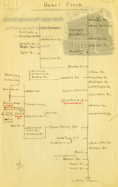
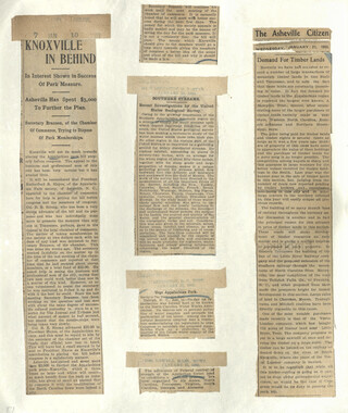
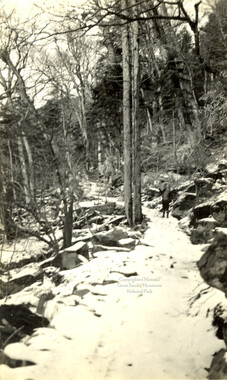
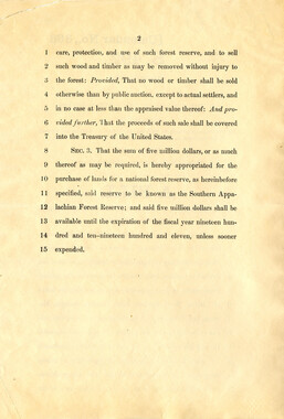
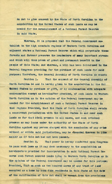
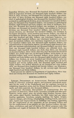
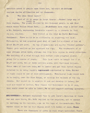
These copies of federal court records were collected by photographer, George Masa. Born Masahara Iizuka and raised in Japan, photographer George Masa (1881-1933) was active in the Appalachian Trail Club and in the movement to establish the Great Smoky Mountains National Park. In 1931, Masa was named to the three-person nomenclature committee for the North Carolina Park Commission and had the responsibility for accurately naming the peaks, streams, and other features. No doubt, these records pertain to the Smokies region and the disposition of land that would eventually become the Great Smoky Mountains National Park.
-


Part of Collection
Great Smoky Mountains - A Park for America