Western Carolina University (1)
View all
- Great Smoky Mountains - A Park for America (24)
- Canton Champion Fibre Company (0)
- Cherokee Traditions (0)
- Civil War in Southern Appalachia (0)
- Craft Revival (0)
- Highlights from Western Carolina University (0)
- Horace Kephart (0)
- Journeys Through Jackson (0)
- LGBTQIA+ Archive of Jackson County (0)
- Oral Histories of Western North Carolina (0)
- Picturing Appalachia (0)
- Stories of Mountain Folk (0)
- Travel Western North Carolina (0)
- Western Carolina University Fine Art Museum Vitreograph Collection (0)
- Western Carolina University Herbarium (0)
- Western Carolina University: Making Memories (0)
- Western Carolina University Publications (0)
- Western Carolina University Restricted Electronic Theses and Dissertations (0)
- Western North Carolina Regional Maps (0)
- World War II in Southern Appalachia (0)
University of North Carolina Asheville (0)
View all
- Faces of Asheville (0)
- Forestry in Western North Carolina (0)
- Grove Park Inn Photograph Collection (0)
- Isaiah Rice Photograph Collection (0)
- Morse Family Chimney Rock Park Collection (0)
- Picturing Asheville and Western North Carolina (0)
- Allanstand Cottage Industries (62)
- Appalachian National Park Association (53)
- Bennett, Kelly, 1890-1974 (1388)
- Berry, Walter (76)
- Brasstown Carvers (40)
- Carver, George Washington, 1864?-1943 (26)
- Cathey, Joseph, 1803-1874 (1)
- Champion Fibre Company (233)
- Champion Paper and Fibre Company (297)
- Cherokee Indian Fair Association (16)
- Cherokee Language Program (22)
- Crowe, Amanda (40)
- Edmonston, Thomas Benton, 1842-1907 (7)
- Ensley, A. L. (Abraham Lincoln), 1865-1948 (275)
- Fromer, Irving Rhodes, 1913-1994 (70)
- George Butz (BFS 1907) (46)
- Goodrich, Frances Louisa (120)
- Grant, George Alexander, 1891-1964 (96)
- Heard, Marian Gladys (60)
- Kephart, Calvin, 1883-1969 (15)
- Kephart, Horace, 1862-1931 (313)
- Kephart, Laura, 1862-1954 (39)
- Laney, Gideon Thomas, 1889-1976 (439)
- Masa, George, 1881-1933 (61)
- McElhinney, William Julian, 1896-1953 (44)
- Niggli, Josephina, 1910-1983 (10)
- North Carolina Park Commission (105)
- Osborne, Kezia Stradley (9)
- Owens, Samuel Robert, 1918-1995 (11)
- Penland Weavers and Potters (36)
- Roberts, Vivienne (15)
- Roth, Albert, 1890-1974 (142)
- Schenck, Carl Alwin, 1868-1955 (1)
- Sherrill's Photography Studio (2565)
- Southern Highland Handicraft Guild (127)
- Southern Highlanders, Inc. (71)
- Stalcup, Jesse Bryson (46)
- Stearns, I. K. (213)
- Thompson, James Edward, 1880-1976 (226)
- United States. Indian Arts and Crafts Board (130)
- USFS (683)
- Vance, Zebulon Baird, 1830-1894 (1)
- Weaver, Zebulon, 1872-1948 (58)
- Western Carolina College (230)
- Western Carolina Teachers College (282)
- Western Carolina University (1794)
- Western Carolina University. Mountain Heritage Center (18)
- Whitman, Walt, 1819-1892 (10)
- Wilburn, Hiram Coleman, 1880-1967 (73)
- Williams, Isadora (3)
- Cain, Doreyl Ammons (0)
- Crittenden, Lorraine (0)
- Rhodes, Judy (0)
- Smith, Edward Clark (0)
- 1850s (1)
- 1860s (1)
- 1870s (3)
- 1880s (2)
- 1900s (2)
- 1910s (4)
- 1920s (23)
- 1930s (20)
- 1940s (10)
- 1950s (4)
- 1970s (4)
- 1980s (3)
- 1990s (3)
- 2000s (21)
- 1600s (0)
- 1700s (0)
- 1800s (0)
- 1810s (0)
- 1820s (0)
- 1830s (0)
- 1840s (0)
- 1890s (0)
- 1960s (0)
- 2010s (0)
- 2020s (0)
- Great Smoky Mountains National Park (N.C. and Tenn.) (1)
- Haywood County (N.C.) (24)
- Appalachian Region, Southern (0)
- Asheville (N.C.) (0)
- Avery County (N.C.) (0)
- Blount County (Tenn.) (0)
- Buncombe County (N.C.) (0)
- Cherokee County (N.C.) (0)
- Clay County (N.C.) (0)
- Graham County (N.C.) (0)
- Henderson County (N.C.) (0)
- Jackson County (N.C.) (0)
- Knox County (Tenn.) (0)
- Knoxville (Tenn.) (0)
- Lake Santeetlah (N.C.) (0)
- Macon County (N.C.) (0)
- Madison County (N.C.) (0)
- McDowell County (N.C.) (0)
- Mitchell County (N.C.) (0)
- Polk County (N.C.) (0)
- Qualla Boundary (0)
- Rutherford County (N.C.) (0)
- Swain County (N.C.) (0)
- Transylvania County (N.C.) (0)
- Watauga County (N.C.) (0)
- Waynesville (N.C.) (0)
- Yancey County (N.C.) (0)
- Clippings (information Artifacts) (7)
- Land Surveys (22)
- Letters (correspondence) (3)
- Manuscripts (documents) (8)
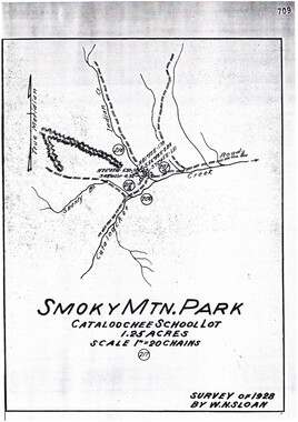
- Maps (documents) (9)
- Photographs (19)
- Portraits (8)
- Publications (documents) (23)
- Aerial Photographs (0)
- Aerial Views (0)
- Albums (books) (0)
- Articles (0)
- Artifacts (object Genre) (0)
- Bibliographies (0)
- Biography (general Genre) (0)
- Cards (information Artifacts) (0)
- Crafts (art Genres) (0)
- Depictions (visual Works) (0)
- Design Drawings (0)
- Drawings (visual Works) (0)
- Envelopes (0)
- Facsimiles (reproductions) (0)
- Fiction (general Genre) (0)
- Financial Records (0)
- Fliers (printed Matter) (0)
- Glass Plate Negatives (0)
- Guidebooks (0)
- Internegatives (0)
- Interviews (0)
- Memorandums (0)
- Minutes (administrative Records) (0)
- Negatives (photographs) (0)
- Newsletters (0)
- Newspapers (0)
- Occupation Currency (0)
- Paintings (visual Works) (0)
- Pen And Ink Drawings (0)
- Periodicals (0)
- Personal Narratives (0)
- Plans (maps) (0)
- Poetry (0)
- Postcards (0)
- Programs (documents) (0)
- Questionnaires (0)
- Scrapbooks (0)
- Sheet Music (0)
- Slides (photographs) (0)
- Songs (musical Compositions) (0)
- Sound Recordings (0)
- Specimens (0)
- Speeches (documents) (0)
- Text Messages (0)
- Tintypes (photographs) (0)
- Transcripts (0)
- Video Recordings (physical Artifacts) (0)
- Vitreographs (0)
- Cataloochee History Project (2)
- A.L. Ensley Collection (0)
- Appalachian Industrial School Records (0)
- Appalachian National Park Association Records (0)
- Axley-Meroney Collection (0)
- Bayard Wootten Photograph Collection (0)
- Bethel Rural Community Organization Collection (0)
- Blumer Collection (0)
- C.W. Slagle Collection (0)
- Canton Area Historical Museum (0)
- Carlos C. Campbell Collection (0)
- Cherokee Studies Collection (0)
- Daisy Dame Photograph Album (0)
- Daniel Boone VI Collection (0)
- Doris Ulmann Photograph Collection (0)
- Elizabeth H. Lasley Collection (0)
- Elizabeth Woolworth Szold Fleharty Collection (0)
- Frank Fry Collection (0)
- George Masa Collection (0)
- Gideon Laney Collection (0)
- Hazel Scarborough Collection (0)
- Hiram C. Wilburn Papers (0)
- Historic Photographs Collection (0)
- Horace Kephart Collection (0)
- Humbard Collection (0)
- Hunter and Weaver Families Collection (0)
- I. D. Blumenthal Collection (0)
- Isadora Williams Collection (0)
- Jesse Bryson Stalcup Collection (0)
- Jim Thompson Collection (0)
- John B. Battle Collection (0)
- John C. Campbell Folk School Records (0)
- John Parris Collection (0)
- Judaculla Rock project (0)
- Kelly Bennett Collection (0)
- Love Family Papers (0)
- Major Wiley Parris Civil War Letters (0)
- Map Collection (0)
- McFee-Misemer Civil War Letters (0)
- Mountain Heritage Center Collection (0)
- Norburn - Robertson - Thomson Families Collection (0)
- Pauline Hood Collection (0)
- Pre-Guild Collection (0)
- Qualla Arts and Crafts Mutual Collection (0)
- R.A. Romanes Collection (0)
- Rosser H. Taylor Collection (0)
- Samuel Robert Owens Collection (0)
- Sara Madison Collection (0)
- Sherrill Studio Photo Collection (0)
- Smoky Mountains Hiking Club Collection (0)
- Stories of Mountain Folk - Radio Programs (0)
- The Reporter, Western Carolina University (0)
- Venoy and Elizabeth Reed Collection (0)
- WCU Gender and Sexuality Oral History Project (0)
- WCU Mountain Heritage Center Oral Histories (0)
- WCU Oral History Collection - Mountain People, Mountain Lives (0)
- WCU Students Newspapers Collection (0)
- Western North Carolina Tomorrow Black Oral History Project (0)
- William Williams Stringfield Collection (0)
- Zebulon Weaver Collection (0)
- Church buildings (2)
- Maps (5)
- African Americans (0)
- Appalachian Trail (0)
- Artisans (0)
- Cherokee art (0)
- Cherokee artists -- North Carolina (0)
- Cherokee language (0)
- Cherokee pottery (0)
- Cherokee women (0)
- Civilian Conservation Corps (U.S.) (0)
- College student newspapers and periodicals (0)
- Dams (0)
- Dance (0)
- Education (0)
- Floods (0)
- Folk music (0)
- Forced removal, 1813-1903 (0)
- Forest conservation (0)
- Forests and forestry (0)
- Gender nonconformity (0)
- Great Smoky Mountains National Park (N.C. and Tenn.) (0)
- Hunting (0)
- Landscape photography (0)
- Logging (0)
- Mines and mineral resources (0)
- North Carolina -- Maps (0)
- Paper industry (0)
- Postcards (0)
- Pottery (0)
- Railroad trains (0)
- Rural electrification -- North Carolina, Western (0)
- School integration -- Southern States (0)
- Segregation -- North Carolina, Western (0)
- Slavery (0)
- Sports (0)
- Storytelling (0)
- Waterfalls -- Great Smoky Mountains (N.C. and Tenn.) (0)
- Weaving -- Appalachian Region, Southern (0)
- Wood-carving -- Appalachian Region, Southern (0)
- World War, 1939-1945 (0)
- StillImage (19)
- Text (24)
- MovingImage (0)
- Sound (0)
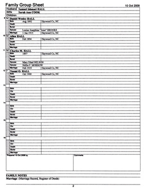
Cataloochee tract 295: Robert Partin


Cataloochee tract 295: Robert Partin
GSMNP_80235
Item 3 - Cataloochee tract 295: Robert Partin

Cataloochee tract 295: Robert Partin
GSMNP_Cata-295_Palmer_32
Item
Item’s are ‘child’ level descriptions to ‘parent’ objects, (e.g. one page of a whole book).
-
-
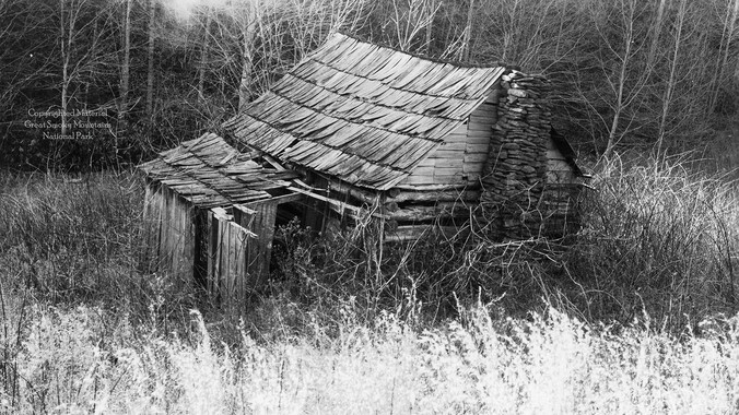
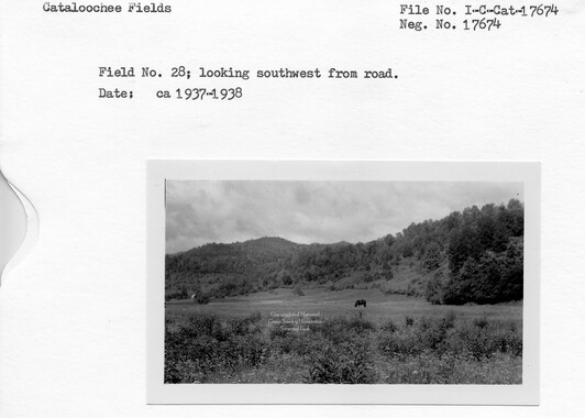
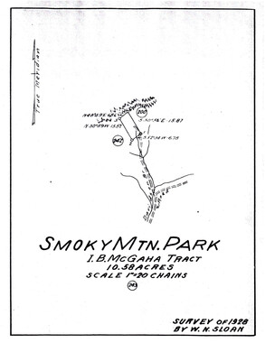
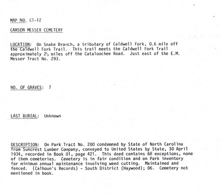
,. CATALOOCHEE HISTORIC DISTRICT: CULTURAL LANDSCAPE REPORT GREAT SMOKY MOUNTAINS NATIONAL PARK January 2000 Dianne L. Flaugh Historical Landscape Architect Cultural Resources Resource Management Great Smoky Mountains National Park National Park Service I I I I I I I I I I I • CHAPTER 4: INDIVIDUAL TRACTS E. M. Messer Tract (293) J. L. C. Messer Tract (292) Location 157 These two tracts are located along Snake Branch in Caldwell Fork. Tract 292 is a 50.26- acre parcel, beginning at the juncture of Snake Branch with Caldwell Fork and extending eastward along Snake Branch. Tract 293 is a 73.5-acre parcel that abuts the east boundary of tract 292. History This land was first bonded to G. N. Penland in 187 4, from the Love holdings. Beginning in 1892, the property went passed various hands until Steve and Mary Woody bonded the land to E. M. Messer in 1895. In 1897, the land was transferred to Will Messer (son of Elijah) but returned to Elijah 's name the following year. In 1918, Elijah M. Messer transferred tract 292 to J. L. C. Messer (Carson) in return for home and home comforts. Elijah Messer also transferred adjoining tracts of land to his son George (tract 2~4) and to Nicey M. Parton (tract 295). The NCPC purchased all of these tracts in 1930. Little is known of the early history of these tracts. None of the early owners of the property appear on any of the agricultural census records. It is possible that they rented the property to others during their ownership. Elijah Messer and his first wife Christina M. arrived in Cataloochee just after the Civil War, settling first on Messer Branch and later moving to Caldwell Fork (year unknown).' They first appear on the census records ofCataloochee in 1880, along with five children. 2 He listed his occupation as a farmer but was known as an expert axman, comerman and stonemason. He also had the reputation as one ofthe best fiddle players in the region.3 It is unknown if he was living in Caldwell Fork in 1880, but agriculture census records show that he farmed a fifty acre tract. This land included seventeen acres of cleared land. Eight acres was devoted to com and three to wheat. Livestock included working animals, cattle, sheep, and swine, but the majority of his stock was swine. His swineherd at that time numbered nineteen hogs. By 1900, the Elijah Messer household in Caldwell Fork included his second wife Elizabeth; sons John L. and George M.; and sister Nancy [Nicey]. By this time Will Messer and Rachel Cook had already established their own household in Little Cataloochee. Vegetation NCPC records for tract 292 indicate that it consisted of thirty acres of cleared land and twenty acres of woodland. Tract 293 consisted of thirty-five acres of cleared land and thirty-eight and one-half acres of woodland. Details about the types of crops grown by the Messers, and the number of acres devoted to differing crops are unknown. A photograph (ca. 193 7) of the Carson Messer house shows cleared land southwest of the house. 158 C ULTIJRAL L ANDSCAPE REPORT: C ATALOOCHEE HISTORIC D ISTRICT Circulation From the road along Caldwell Fork Creek, a road branched off to run eastward along Snake Branch. This route provided access to these tracts and those further up Snake Branch. On tract 293, a trail extended northward to cross Snake Ridge. Structures, Furnishings, and Objects NCPC records for tract 292 indicate that it included a gristmill, four-room log house, six-stall barn, two shops and a springhouse. Later building survey notes provide additional information and noted that the site had once also included tub mill that had been removed. The overshot mill was a frame building weatherboarded with rived hemlock (figure 60). All of the mill equipment had already been removed from the structure before the NCPC purchased the property. Figure 60. Carson Messer Mill, ca. 1930. Wilburn Photo Albwn, GRSM Archives. The log house stood one and one-half stories high and was constructed of hemlock, poplar, and chestnut logs. The dovetailed logs were chinked with split rails outside and rived boards inside. The house included a front porch and frame room addition (figure 61). One former resident of Caldwell Fork remembers the Carson Messer house for it's running water. The house was built against a bank out of which a two-inch stream of water flowed into the house. 4 The barn measured 61' by 33' in size. Its pens were nine feet high with notched corners. The crib had dovetailed comers. The barn was constructed of poplar and pine logs and its roof of split shingles supported by silver bell pole. Other outbuildings included a smokehouse and springhouse. The log smokehouse stood seven logs high and measured 10' by 12' in size. The springhouse measured 6' by 8' , stood eight logs high, and had a four-foot overhang. This springhouse was well constructed of poplar and hemlock with dovetail corners, rived chinking on the inside, and weatherboarded as beveled siding. Troughs stood outside. The building survey also noted that the site included a sorghum furnace. I I I I I I I I I I~ I I I I I I I ' I I I I I ~~ ~. CHAPTER 4: INDIVIDUAL TRACTS 159 Tract 293 included a two-room log house and three old sheds. Later building survey notes provide little additional information other than calling for the removal of a frame house, shed, and pigpen. 5 Figure 61. Carson Messer House, 1937. GRSM Archives. Existing Conditions The area of Messer tracts 293 and 294 is included within subzone Natural EnvironmentType I, which emphasizes the natural environment. Both tracts have entirely reforested. Tulip poplar, white pine, and maple dominate the forest cover of formerly open agriculturalland. The historic routes through these tracts are still evident and form the basis of Boogerman Trail. The Boogerman Trail is a popular loop trail in Cataloochee and is open only to foot traffic. Also found on the Messer tracts are road traces; one leading to a field area above a stone retaining wall, and another along the nonh bank of Snake Branch. This second trace road is possibly associated with the gristmill. None of the structures documented as part ofbuilding survey work are extant. Traces of rail fencing are evident along Snake Branch along side the trace road. Photographs of the mill also depict rail fencing. Extensive stone retaining walls are found on both tracts. On the Carson Messer tract one 'L' shaped wall extends thirty-five feet along Boogerman trail and seventy feet northward. On the E. M. Messer tract a five-foot high retaining wall extends approximately one hundred feet along Boogerman trail. A break in this wall marks a road trace leading to the field area above this wall. A small cemetery known as the Carson Messer cemetery is found above this field area. It is surrounded with wire fence and includes at least two graves marked with uninscribed limestone grave markers. Analysis and Evaluation This site is associated with the Messer family and was the site of a large gristmill. Reforestation and the removal ofbuildings have impacted the site. However, the_ reforested agricultural land remains evident, dominated by pioneer tree species. While no buildings remain standing, there are small scale landscape elements and remnants that 160 CutllJRAL LANDSCAPE REPORT: CATALOOCHEE HlsTORIC DISTRICT illustrate the historic use of the site. These include structural elements such as walls, fences, and log remnants of the bam. A cemetery is also found here. Historic circulation patterns through the site remain evident. The mountainous setting and remaining landscape elements attest to the difficult nature of subsistence farming in Cataloochee. NOTES 1 Elizabeth Powers and Mark Hannah. Cataloochee:Lost Settlement of the Smokies (Charleston, SC: Blazer Print, 1983), 51. 2 Children included three sons and two daughters: James, 13; William, 10; Sarah, 7; Chassie, 5; and George, 2. 3 Roy Carroll and Raymond H. Pulley, "Historic Structures Report: Jim Hannah Cabin, Will Messer Bam, and Dan Cook Cabin," (Appalachian State University, Department of History, 1976), 22. 4 Thad Sutton, Interview by Jacqueline Lott and author, Written notes, Waynesville, NC, 12 January 1998. 5 Charles Grossman, Grossman Notebooks, B-4, GRSM Archives. I I I I I I I I I I I I •: •: I I I I I
Object
Object’s are ‘parent’ level descriptions to ‘children’ items, (e.g. a book with pages).
-
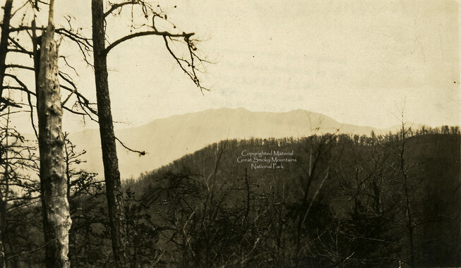
This 33-acre tract 295 in Cataloochee was owned by Robert Lee Partin and Lucinda Matilda (Nicie) Messer. While, in general, the Great Smoky Mountains region was sparsely populated, the Cataloochee Valley remained an exception. By 1900, the population of Cataloochee had grown to 1,000 residents living in hundreds of log and frame homes. A few historic buildings have been preserved on site, including two churches, a school, several homes, and outbuildings. The North Carolina Park Commission was tasked with purchasing land for the Great Smoky Mountains National Park and people living in Cataloochee were among those displaced. Cataloochee families continue to return for annual reunions. In 2001, the National Park Service re-introduced elk into the valley.
-


Part of Collection
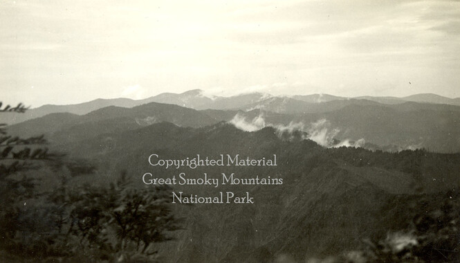
Great Smoky Mountains - A Park for America