- Canton Champion Fibre Company (2308)
- Cherokee Traditions (291)
- Civil War in Southern Appalachia (165)
- Craft Revival (1942)
- Great Smoky Mountains - A Park for America (2946)
- Highlights from Western Carolina University (430)
- Horace Kephart (941)
- Journeys Through Jackson (159)
- LGBTQIA+ Archive of Jackson County (85)
- Oral Histories of Western North Carolina (314)
- Picturing Appalachia (6873)
- Stories of Mountain Folk (413)
- Travel Western North Carolina (160)
- Western Carolina University Fine Art Museum Vitreograph Collection (129)
- Western Carolina University Herbarium (92)
- Western Carolina University: Making Memories (738)
- Western Carolina University Publications (2491)
- Western Carolina University Restricted Electronic Theses and Dissertations (146)
- Western North Carolina Regional Maps (71)
- World War II in Southern Appalachia (131)
- Allanstand Cottage Industries (62)
- Appalachian National Park Association (53)
- Bennett, Kelly, 1890-1974 (1463)
- Berry, Walter (76)
- Brasstown Carvers (40)
- Carver, George Washington, 1864?-1943 (26)
- Cathey, Joseph, 1803-1874 (1)
- Champion Fibre Company (233)
- Champion Paper and Fibre Company (297)
- Cherokee Indian Fair Association (16)
- Cherokee Language Program (22)
- Crowe, Amanda (40)
- Edmonston, Thomas Benton, 1842-1907 (7)
- Ensley, A. L. (Abraham Lincoln), 1865-1948 (275)
- Fromer, Irving Rhodes, 1913-1994 (70)
- George Butz (BFS 1907) (46)
- Goodrich, Frances Louisa (120)
- Grant, George Alexander, 1891-1964 (96)
- Heard, Marian Gladys (60)
- Kephart, Calvin, 1883-1969 (15)
- Kephart, Horace, 1862-1931 (313)
- Kephart, Laura, 1862-1954 (39)
- Laney, Gideon Thomas, 1889-1976 (439)
- Masa, George, 1881-1933 (61)
- McElhinney, William Julian, 1896-1953 (44)
- Niggli, Josephina, 1910-1983 (10)
- North Carolina Park Commission (105)
- Osborne, Kezia Stradley (9)
- Owens, Samuel Robert, 1918-1995 (11)
- Penland Weavers and Potters (36)
- Roberts, Vivienne (15)
- Roth, Albert, 1890-1974 (142)
- Schenck, Carl Alwin, 1868-1955 (1)
- Sherrill's Photography Studio (2565)
- Southern Highland Handicraft Guild (127)
- Southern Highlanders, Inc. (71)
- Stalcup, Jesse Bryson (46)
- Stearns, I. K. (213)
- Thompson, James Edward, 1880-1976 (226)
- United States. Indian Arts and Crafts Board (130)
- USFS (683)
- Vance, Zebulon Baird, 1830-1894 (1)
- Weaver, Zebulon, 1872-1948 (58)
- Western Carolina College (230)
- Western Carolina Teachers College (282)
- Western Carolina University (2008)
- Western Carolina University. Mountain Heritage Center (18)
- Whitman, Walt, 1819-1892 (10)
- Wilburn, Hiram Coleman, 1880-1967 (73)
- Williams, Isadora (3)
- Cain, Doreyl Ammons (0)
- Crittenden, Lorraine (0)
- Rhodes, Judy (0)
- Smith, Edward Clark (0)
- Appalachian Region, Southern (2569)
- Asheville (N.C.) (1923)
- Avery County (N.C.) (26)
- Blount County (Tenn.) (195)
- Buncombe County (N.C.) (1672)
- Cherokee County (N.C.) (283)
- Clay County (N.C.) (555)
- Graham County (N.C.) (236)
- Great Smoky Mountains National Park (N.C. and Tenn.) (519)
- Haywood County (N.C.) (3569)
- Henderson County (N.C.) (70)
- Jackson County (N.C.) (4912)
- Knox County (Tenn.) (35)
- Knoxville (Tenn.) (13)
- Lake Santeetlah (N.C.) (10)
- Macon County (N.C.) (420)
- Madison County (N.C.) (215)
- McDowell County (N.C.) (39)
- Mitchell County (N.C.) (132)
- Polk County (N.C.) (35)
- Qualla Boundary (982)
- Rutherford County (N.C.) (76)
- Swain County (N.C.) (2182)
- Transylvania County (N.C.) (270)
- Watauga County (N.C.) (12)
- Waynesville (N.C.) (86)
- Yancey County (N.C.) (72)
- Aerial Photographs (3)
- Aerial Views (60)
- Albums (books) (4)
- Articles (1)
- Artifacts (object Genre) (228)
- Bibliographies (1)
- Biography (general Genre) (2)
- Cards (information Artifacts) (38)
- Clippings (information Artifacts) (191)
- Copybooks (instructional Materials) (3)
- Crafts (art Genres) (622)
- Depictions (visual Works) (21)
- Design Drawings (1)
- Drawings (visual Works) (185)
- Envelopes (73)
- Exhibitions (events) (1)
- Facsimiles (reproductions) (1)
- Fiction (general Genre) (4)
- Financial Records (12)
- Fliers (printed Matter) (67)
- Glass Plate Negatives (381)
- Guidebooks (2)
- Internegatives (10)
- Interviews (815)
- Land Surveys (102)
- Letters (correspondence) (1013)
- Manuscripts (documents) (618)
- Maps (documents) (177)
- Memorandums (25)
- Minutes (administrative Records) (59)
- Negatives (photographs) (6090)
- Newsletters (1290)
- Newspapers (2)
- Notebooks (8)
- Occupation Currency (1)
- Paintings (visual Works) (1)
- Pen And Ink Drawings (1)
- Periodicals (193)
- Personal Narratives (10)
- Photographs (12976)
- Plans (maps) (1)
- Poetry (5)
- Portraits (4568)
- Postcards (329)
- Programs (documents) (181)
- Publications (documents) (2443)
- Questionnaires (65)
- Relief Prints (26)
- Sayings (literary Genre) (1)
- Scrapbooks (282)
- Sheet Music (2)
- Slides (photographs) (402)
- Songs (musical Compositions) (2)
- Sound Recordings (796)
- Specimens (92)
- Speeches (documents) (18)
- Tintypes (photographs) (8)
- Transcripts (322)
- Video Recordings (physical Artifacts) (23)
- Text Messages (0)
- A.L. Ensley Collection (275)
- Appalachian Industrial School Records (7)
- Appalachian National Park Association Records (336)
- Axley-Meroney Collection (2)
- Bayard Wootten Photograph Collection (20)
- Bethel Rural Community Organization Collection (7)
- Blumer Collection (5)
- C.W. Slagle Collection (20)
- Canton Area Historical Museum (2110)
- Carlos C. Campbell Collection (462)
- Cataloochee History Project (64)
- Cherokee Studies Collection (4)
- Daisy Dame Photograph Album (5)
- Daniel Boone VI Collection (1)
- Doris Ulmann Photograph Collection (112)
- Elizabeth H. Lasley Collection (1)
- Elizabeth Woolworth Szold Fleharty Collection (4)
- Frank Fry Collection (95)
- George Masa Collection (173)
- Gideon Laney Collection (452)
- Hazel Scarborough Collection (2)
- Hiram C. Wilburn Papers (28)
- Historic Photographs Collection (236)
- Horace Kephart Collection (861)
- Humbard Collection (33)
- Hunter and Weaver Families Collection (1)
- I. D. Blumenthal Collection (4)
- Isadora Williams Collection (4)
- Jesse Bryson Stalcup Collection (47)
- Jim Thompson Collection (224)
- John B. Battle Collection (7)
- John C. Campbell Folk School Records (80)
- John Parris Collection (6)
- Judaculla Rock project (2)
- Kelly Bennett Collection (1482)
- Love Family Papers (11)
- Major Wiley Parris Civil War Letters (3)
- Map Collection (12)
- McFee-Misemer Civil War Letters (34)
- Mountain Heritage Center Collection (4)
- Norburn - Robertson - Thomson Families Collection (44)
- Pauline Hood Collection (7)
- Pre-Guild Collection (2)
- Qualla Arts and Crafts Mutual Collection (12)
- R.A. Romanes Collection (681)
- Rosser H. Taylor Collection (1)
- Samuel Robert Owens Collection (94)
- Sara Madison Collection (144)
- Sherrill Studio Photo Collection (2558)
- Smoky Mountains Hiking Club Collection (616)
- Stories of Mountain Folk - Radio Programs (374)
- The Reporter, Western Carolina University (510)
- Venoy and Elizabeth Reed Collection (16)
- WCU Gender and Sexuality Oral History Project (32)
- WCU Mountain Heritage Center Oral Histories (25)
- WCU Oral History Collection - Mountain People, Mountain Lives (71)
- WCU Students Newspapers Collection (1923)
- Western North Carolina Tomorrow Black Oral History Project (69)
- William Williams Stringfield Collection (2)
- Zebulon Weaver Collection (109)
- African Americans (390)
- Appalachian Trail (35)
- Artisans (521)
- Cherokee art (84)
- Cherokee artists -- North Carolina (10)
- Cherokee language (21)
- Cherokee pottery (101)
- Cherokee women (208)
- Church buildings (189)
- Civilian Conservation Corps (U.S.) (111)
- College student newspapers and periodicals (2012)
- Dams (107)
- Dance (1023)
- Education (222)
- Floods (61)
- Folk music (1015)
- Forced removal, 1813-1903 (2)
- Forest conservation (220)
- Forests and forestry (1184)
- Gender nonconformity (4)
- Great Smoky Mountains National Park (N.C. and Tenn.) (181)
- Hunting (45)
- Landscape photography (25)
- Logging (119)
- Maps (83)
- Mines and mineral resources (8)
- North Carolina -- Maps (18)
- Paper industry (38)
- Postcards (255)
- Pottery (135)
- Railroad trains (72)
- Rural electrification -- North Carolina, Western (3)
- School integration -- Southern States (2)
- Segregation -- North Carolina, Western (5)
- Slavery (5)
- Sports (452)
- Storytelling (243)
- Waterfalls -- Great Smoky Mountains (N.C. and Tenn.) (66)
- Weaving -- Appalachian Region, Southern (280)
- Wood-carving -- Appalachian Region, Southern (328)
- World War, 1939-1945 (173)
Cataloochee tract 212a: Thomas Caldwell

Cataloochee tract 212a: Thomas Caldwell
GSMNP_Cata-212a
Cataloochee tract 212a: Thomas Caldwell
GSMNP_80235_107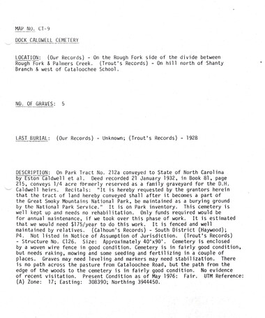
Cataloochee tract 212a: Thomas Caldwell
GSMNP_Cata-212a_CT-9_01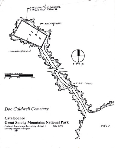
Cataloochee tract 212a: Thomas Caldwell
GSMNP_Cata-212a_CT-9_02
Cataloochee tract 212a: Thomas Caldwell
GSMNP_02120_III-B-10043_a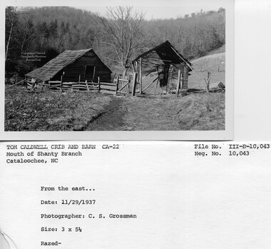
Cataloochee tract 212a: Thomas Caldwell
GSMNP_02120_III-B-10043_b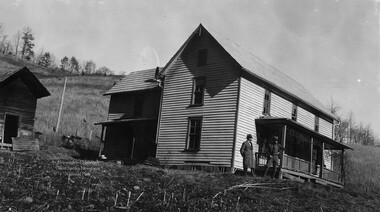
Cataloochee tract 212a: Thomas Caldwell
GSMNP_02120_III-B-10044_a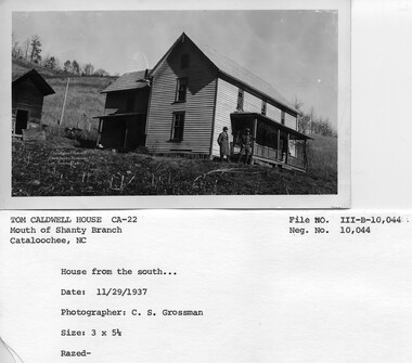
Cataloochee tract 212a: Thomas Caldwell
GSMNP_02120_III-B-10044_b
Cataloochee tract 212a: Thomas Caldwell
GSMNP_02120_III-B-10045_a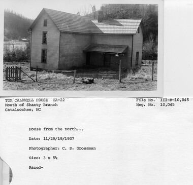
Cataloochee tract 212a: Thomas Caldwell
GSMNP_02120_III-B-10045_b
Cataloochee tract 212a: Thomas Caldwell
GSMNP_02120_III-B-10046_a
Cataloochee tract 212a: Thomas Caldwell
GSMNP_02120_III-B-10046_bItem’s are ‘child’ level descriptions to ‘parent’ objects, (e.g. one page of a whole book).
-
-
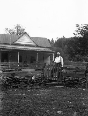
CATALOOCHEE HISTORIC DISTRICT: CULTURAL LANDSCAPE REPORT GREAT SMOKY MOUNTAINS NATIONAL PARK January 2000 Dianne L. Flaugh Historical Landscape Architect Cultural Resources Resource Management Great Smoky Mountains National Park National Park Service CHAPTER 4: INDIVIDUAL TRACTS Thomas Caldwell Tract (212a) This tract is also known as the Doc Caldwell Place and includes the Doc Caldwell Cemetery. Location 107 Tract 212a is a 46.27-acre parcel located along the north side of Shanty Branch and next to Beech Grove School. History Originally this tract was part of one hundred fifty acres deeded to Jesse Palmer in 1857, from Love holdings. In 1896, Doc and Sarah Caldwell acquired fifty acres of land from the estate of Jesse Palmer, who was Sarah's father. Doc built a home and moved his family from parcel212, located farther up Shanty Branch. Both Sarah and Doc died soon after, leaving several young children who were separated and raised by various family members.' In 1907, the Board of Education purchased one an one-quarter acres from the fifty acre tract using the land for Beech Grove School. By 1913, William A. Palmer and his wife Milia had gained control of parcel 212a. Eventually Thomas Caldweij, the son of Doc Caldwell, acquired both parcels 212 and 212a. They remained in his possession until the NCPC acquired both parcels in 1930 for $4,800. The Thomas Caldwell family leased and occupied parcel212a until1936.2The Thomas Caldwell house was later leased and occupied for a short time by Lush Caldwell and his family.3 Little is known of the early use ofthis tract by Jesse Palmer and Doc Caldwell. It is likely that portions of this property, especially the level bottom land, were cleared and farmed. It is unknown who occupied the property in the years intervening between the death of Doc Caldwell and its acquisition by Thomas Caldwell. Gudger Palmer recalls the tract as a rental property owned by his father, William Palmer.4 Vegetation NCPC records indicate that tract 212a consisted of twenty acres of cultivated fields, eight acres of pasture, and nineteen acres of woodland. Survey maps (ca. 1935) of Big Cataloochee Valley indicated the location of five apple trees southeast ofthe Thomas Caldwell house. Four of these trees were large (36") and may have been the remnants of a larger orchard. The fifth apple tree was smaller and found closer to the house. Photographs (ca. 1937) reveal a number of other details about the site. A vine grew on the south side of the house front porch. Corn stalks remain visible in the area s~:mth of the barn and west of the house. A cleared, grass covered slope lay to the east and north of . the house. This slope was topped with a line oftrees. ">! .!, ',, •f' j :\----..." i !· i : ~ ! ( 108 C ULTURAL LANDSCAPE REPORT: CATALOOCHEE HISTORIC DISTRICT Circulation The old settler road ran along Rough Fork Creek through the southeast edge of this tract. A trace branched off this to run along the south bank of Shanty Branch for approximately 650 feet before fording the branch to reach the homesite. The trace passed south of the barn and north of a springhouse and garage before continuing up Shanty Branch (figure 37). Structures, Furnishings, and Objects Fig,ure 37. Road leading up Shanty Branch above the Thomas Caldwell House, 1937. GRSM Archives. At the time the parcel was acquired by the NCPC, the structures included a house (ca. 1890), corncrib, smokehouse, and springhouse; all of frame construction. A barn log and lumber barn was also found on the parcel These structures and an additional structure identified as a garage were included in a survey drawings (ca. 1935) of this portion of the valley. The buildings sat on a bench overlooking Shanty Branch and above the level fields along Cataloochee Creek. The six-room house stood two stories high and included porches on the east, west, and south sides. It included a central brick chimney and a stamped sheet metal shingled roo£ Close behind the house stood the smokehouse and several beegums. A well-trod path connected the house to the other outbuildings that stood closer to the road up Shanty Branch. A number offences stood in the area surrounding the house and outbuildings. Photographs show that most of these fences were wood post and wire. Some in the area of the barn were constructed of wood, both board and rails. Two gates shown near the house and barn were narrow, wooden gates of simple construction. Fencing also lined both sides of Shanty Branch until ending on the south side approximately one hundred thirty feet from the ford. r---------------------------------------------------------------------------------------------- ... :.-:··. ~. I. , ·. CHAPTER 4: INDIVIDUAL TRACTS 109 Cemetery The Doc Caldwell Cemetery was covered by a separate deed than the remainder of the Thomas Caldwell property. The Caldwell family used the cemetery purchase money to install fencing around the cemetery. 5 Little is known of the historic appearance of the cemetery or the date of its establishment. It likely stood on the dividing line between woodland and cleared land. As an indication of the date of establishment for this cemetery, George L. Caldwell, son of Doc and Sarah Caldwell, died in 1893, and is buried in this cemetery. Views and Vistas 1937 photographs of the Thomas Caldwell house clearly show that the Hiram Caldwell Barn is visible to the south (figure 38). A line of brush growing along the north bank of Shanty Branch was thin enough to allow this view. The clear slope above the house provided excellent views to the south and east. Figure 38. Thomas Caldwell House with Hiram Caldwell Bam visible in distance, 1937. GRSM Archives. Existing Conditions The Thomas Caldwell tract is included in the area designated for historic landscape management. The NPS maintains a trail leading to the Doc Caldwell Cemetery and a small sign along Cataloochee Creek Road directs visitors to the cemetery. Through periodic mowing much of the bottomland on this tract has been maintained as open meadow. The remainder of the cultivated fields have reforested to a mix oftulip poplar and white pine. None of the apple trees noted in the survey drawings survive. The reforested slope and a thicker line of brush along Shanty Branch prohibit the extent of view formerly available from this location. _ The route followed by the old settler road through this portion of Big Cataloochee valley is still followed by traffic through the valley today. The trace along the south side of Shanty Branch is no longer obvious, but it can be traced from the ford across Shanty Branch into the forest line. No extant structures remain at this site. The exact date of their removal is unknown II 0 CULTURAL LANDSCAPE REPORT: CATALOOCHEE HISTORIC DISTRICT but probably occurred shortly after 1940.6The rectangular outline ofthe springhouse is the most obvious indication of a structure. None of the fencing that once ran through the immediate homesite area is apparent. Woven wire fencing is still found along the property line between parcel212a and Beech Grove School. It is also found running uphill from the cemetery and southward to the south boundary line of the parcel. Traces of fencing also remain on the north side of the branch. Forested land now surrounds the cemetery. It is encompassed by a woven wire agricultural style offence supported by metal fence posts. A metal-framed gate covered with the same type ofwoven wire fence provides access at the southeast comer of the cemetery. The entire fence is painted black. This small cemetery contains at least four grave sites including those of Sarah and Dock Caldwell. The NPS includes this cemetery in its yearly cemetery maintenance schedule. A trail leading to the cemetery is maintained by the NPS. Analysis and Evaluation This site has been greatly impacted by reforestation and the loss of structures. However, the lower field areas remain clear and the boundaries of tract remain evident, marked by lines of trees and remnant fencing along fencelines toward Beech Grove School and Shanty Branch. The fields that remain open greatly contribute to the. overall agricultural character of Big Cataloochee Valley. The setting of the cemetery has been impacted by reforestation. Views from the cemetery the surrounding area no longer possible because of reforestation . The use of wire fencing and metal posts to enclose the cemetery is consistent with other cemeteries improved at the time the park was being established. No documentation has been discovered to support the current route to cemetery as the historic route. However, this route does connect the homesite to the cemetery. NOTES 1 Sarah Caldwell died in I 899 and Doc in I 90 I. In the I 900 census the household included Herbert, age 13; Jessie, age 10; Minnie, age 8; Thomas, age 6; and Eston, age 4; and Hirdon (sp?), age 2. 2 Lloyd Caldwell, Interview by Sam Easterby, Written transcript, GRSM Archives, July I973, 12. 3 Will Sutton and Mrs. Cole Sutton, Interview by author, Written notes, Maggie Valley, NC, I 0 August I998. 4 Gudger Palmer, Interview by Jacqueline Lott and author, Written notes, Cataloochee, NC, 27 March 1998. 5 Lloyd Caldwell, Interview by Mike Conner, Written transcript, GRSM Archives, 13 March 1973, 36. 6 The buildings were included in a lease agreement with Lush Caldwell in 1940 but not 1941. Also, the structures are not indicated on the Cove Creek Gap quadrangle 1942 edition.
Object’s are ‘parent’ level descriptions to ‘children’ items, (e.g. a book with pages).
-
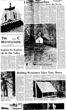
This 46-acre tract 212a in Cataloochee was owned by Thomas Caldwell. While, in general, the Great Smoky Mountains region was sparsely populated, the Cataloochee Valley remained an exception. By 1900, the population of Cataloochee had grown to 1,000 residents living in hundreds of log and frame homes. A few historic buildings have been preserved on site, including two churches, a school, several homes, and outbuildings. The North Carolina Park Commission was tasked with purchasing land for the Great Smoky Mountains National Park and people living in Cataloochee were among those displaced. Cataloochee families continue to return for annual reunions. In 2001, the National Park Service re-introduced elk into the valley.
-
Related items
-
Cataloochee tract 209 and 209a: Johnathan Woody

-
Cataloochee tract 216: J. R. Hall

-
Cataloochee tract 219: Milia Palmer

-
Cataloochee tract 200: Suncrest Lumber Company

-
Cataloochee tract 261: A. C. Bennett

-
Cataloochee tract 224: Jarvis L. Palmer

-
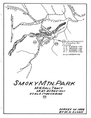
Cataloochee tract 229: M. N. Hall

-
Cataloochee tract 212: Thomas Caldwell

-
Cataloochee tract 230: Ola Baptist Church Lot
-
Cataloochee tract 218: Palmer's Chapel Church
-
Cataloochee tract 227 227a and 227b: J.G. Strikeleather

-
Cataloochee tract 289: Spence Phillips

-
Cataloochee tract 218: Palmer's Chapel Church

-
Cataloochee tract 222: Marion Hub Caldwell

-
Cataloochee tract 215: George H. Caldwell

-
Cataloochee tract 230: Ola Baptist Church Lot
-
Cataloochee tract 219: Milia Palmer

-
Cataloochee tract 212a: Thomas Caldwell

-
Cataloochee tract 230: Ola Baptist Church Lot
-
Cataloochee tract 233: W. B. Bennett

-
Cataloochee tract 213: Charles Ray Caldwell

-
Cataloochee tract 250: Ola School Lot

-
Cataloochee tract 211: F. W. Woody

-
Report of the North Carolina Park Commission, 1931 (12 pages)
-
Cataloochee tract 217: Cataloochee School

-
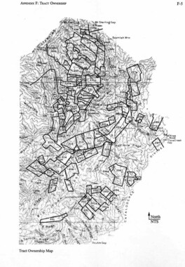
Cataloochee tract owners
-
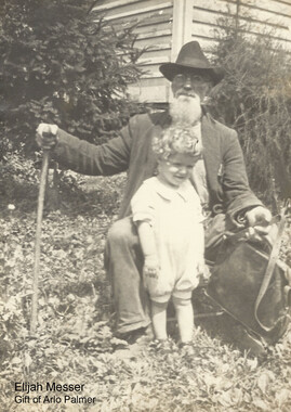
Cataloochee tract 292: J. L. C. Messer
-
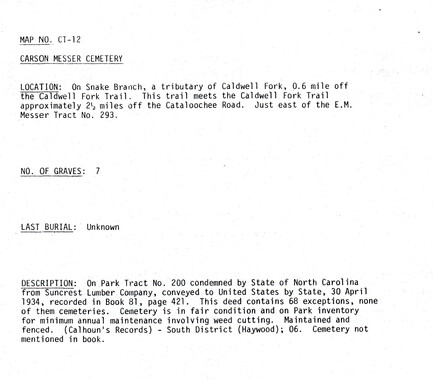
Cataloochee tract 293: E. M. Messer

-
Cataloochee tract 305: Boyd, Clark, and Moody

-
Cataloochee tract 295: Robert Partin

-
Cataloochee tract 226: W. M. Hall

-
Cataloochee tract 296: Robert Palmer

Part of Collection
Great Smoky Mountains - A Park for America
-
Photo Album of the Great Smokey Mountains

-
Report of the Secretary of Agriculture in relation to the forests, rivers, and mountains of the southern Appalachian region

-
Financial receipts and expenditures, 1901

-
Best Loved Scenes in the Smokies

-
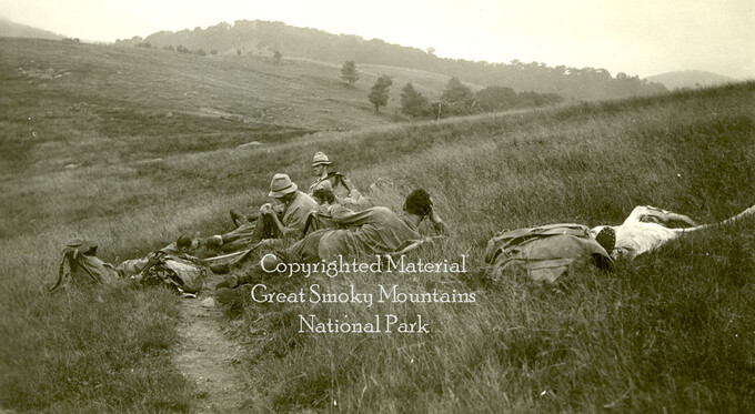
Hikers at Sawtooth Range
-
Cataloochee: fields

-
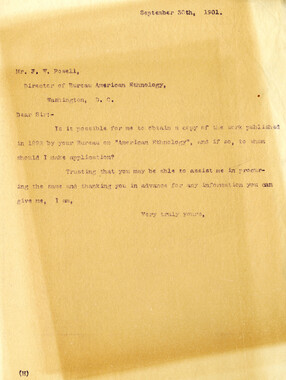
Request for information
-
Secretary of Agriculture report on watersheds

-
Report of the Secretary of Agriculture in relation to the forests, rivers, and mountains of the southern Appalachian region

-
Harvey Broome and Tom Duncan

-
Correspondence regarding 1901 meeting

-
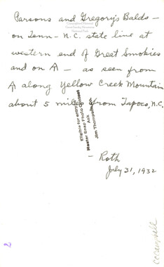
Parson and Gregory Balds
-
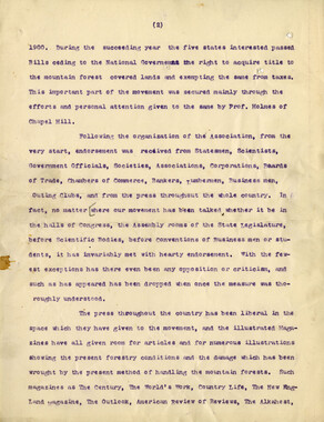
Speech in support of an Appalachian National Park
-
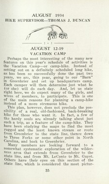
Handbook/ 1934/ Smoky Mountains Hiking Club
-
Complete Report Submitted to Governor Clyde R. Hoey
-
Glimpses of the Plant of the Champion Fibre Co., Canton, North Carolina
-
Appalachian Trail Club bulletin

-
Proposed Appalachian Forest Reserve from a Climatological Point of View

-
Federal court records, Belding et al. v. Hebard: Slick Rock Creek area

-
Correspondence regarding organizational meetings of the Appalachian National Park Association
-
Guide to the Great Smoky Mountains National Park

-
H.O. Wiles, Harriett Fowlkes, Carlos Campbell, Walter Berry
-
Cataloochee tract 293: E. M. Messer
-
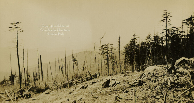
Dead chestnut tree

-
Secretary of Agriculture visit

-
Roadway construction
-
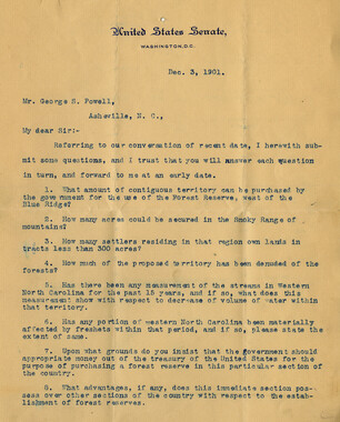
Senator Pritchard's questions regarding the park movement
-
Cataloochee tract 209a: Johnathan Woody
-
Hikers at Spence Field
-
Correspondence: Horace Kephart to Zebulon Weaver, December 24, 1924
-
Cataloochee tract 227a: J.G. Strikeleather

-
Hardwood Bark, 1924