- Canton Champion Fibre Company (2308)
- Cherokee Traditions (291)
- Civil War in Southern Appalachia (165)
- Craft Revival (1942)
- George Masa Collection (137)
- Great Smoky Mountains - A Park for America (3080)
- Highlights from Western Carolina University (422)
- Horace Kephart (973)
- Journeys Through Jackson (159)
- LGBTQIA+ Archive of Jackson County (89)
- Oral Histories of Western North Carolina (318)
- Picturing Appalachia (6617)
- Stories of Mountain Folk (413)
- Travel Western North Carolina (153)
- Western Carolina University Fine Art Museum Vitreograph Collection (129)
- Western Carolina University Herbarium (92)
- Western Carolina University: Making Memories (738)
- Western Carolina University Publications (2491)
- Western Carolina University Restricted Electronic Theses and Dissertations (146)
- Western North Carolina Regional Maps (71)
- World War II in Southern Appalachia (131)
- Allanstand Cottage Industries (62)
- Appalachian National Park Association (53)
- Bennett, Kelly, 1890-1974 (1463)
- Berry, Walter (76)
- Brasstown Carvers (40)
- Carver, George Washington, 1864?-1943 (26)
- Cathey, Joseph, 1803-1874 (1)
- Champion Fibre Company (233)
- Champion Paper and Fibre Company (297)
- Cherokee Indian Fair Association (16)
- Cherokee Language Program (22)
- Crowe, Amanda (40)
- Edmonston, Thomas Benton, 1842-1907 (7)
- Ensley, A. L. (Abraham Lincoln), 1865-1948 (275)
- Fromer, Irving Rhodes, 1913-1994 (70)
- George Butz (BFS 1907) (46)
- Goodrich, Frances Louisa (120)
- Grant, George Alexander, 1891-1964 (96)
- Heard, Marian Gladys (60)
- Kephart, Calvin, 1883-1969 (15)
- Kephart, Horace, 1862-1931 (313)
- Kephart, Laura, 1862-1954 (67)
- Laney, Gideon Thomas, 1889-1976 (439)
- Masa, George, 1881-1933 (61)
- McElhinney, William Julian, 1896-1953 (44)
- Niggli, Josephina, 1910-1983 (10)
- North Carolina Park Commission (105)
- Osborne, Kezia Stradley (9)
- Owens, Samuel Robert, 1918-1995 (11)
- Penland Weavers and Potters (36)
- Roberts, Vivienne (15)
- Roth, Albert, 1890-1974 (142)
- Schenck, Carl Alwin, 1868-1955 (1)
- Sherrill's Photography Studio (2565)
- Southern Highland Handicraft Guild (127)
- Southern Highlanders, Inc. (71)
- Stalcup, Jesse Bryson (46)
- Stearns, I. K. (213)
- Thompson, James Edward, 1880-1976 (226)
- United States. Indian Arts and Crafts Board (130)
- USFS (683)
- Vance, Zebulon Baird, 1830-1894 (1)
- Weaver, Zebulon, 1872-1948 (58)
- Western Carolina College (230)
- Western Carolina Teachers College (282)
- Western Carolina University (2008)
- Western Carolina University. Mountain Heritage Center (18)
- Whitman, Walt, 1819-1892 (10)
- Wilburn, Hiram Coleman, 1880-1967 (73)
- Williams, Isadora (3)
- Cain, Doreyl Ammons (0)
- Crittenden, Lorraine (0)
- Rhodes, Judy (0)
- Smith, Edward Clark (0)
- Appalachian Region, Southern (3032)
- Asheville (N.C.) (1945)
- Avery County (N.C.) (26)
- Blount County (Tenn.) (195)
- Buncombe County (N.C.) (1680)
- Cherokee County (N.C.) (283)
- Clay County (N.C.) (556)
- Graham County (N.C.) (238)
- Great Smoky Mountains National Park (N.C. and Tenn.) (525)
- Haywood County (N.C.) (3573)
- Henderson County (N.C.) (70)
- Jackson County (N.C.) (4925)
- Knox County (Tenn.) (35)
- Knoxville (Tenn.) (13)
- Lake Santeetlah (N.C.) (10)
- Macon County (N.C.) (421)
- Madison County (N.C.) (216)
- McDowell County (N.C.) (39)
- Mitchell County (N.C.) (135)
- Polk County (N.C.) (35)
- Qualla Boundary (982)
- Rutherford County (N.C.) (78)
- Swain County (N.C.) (2185)
- Transylvania County (N.C.) (270)
- Watauga County (N.C.) (12)
- Waynesville (N.C.) (86)
- Yancey County (N.C.) (72)
- Aerial Photographs (3)
- Aerial Views (60)
- Albums (books) (4)
- Articles (1)
- Artifacts (object Genre) (228)
- Bibliographies (1)
- Biography (general Genre) (2)
- Cards (information Artifacts) (38)
- Clippings (information Artifacts) (192)
- Copybooks (instructional Materials) (3)
- Crafts (art Genres) (622)
- Depictions (visual Works) (21)
- Design Drawings (1)
- Digital Moving Image Formats (2)
- Drawings (visual Works) (185)
- Envelopes (101)
- Exhibitions (events) (1)
- Facsimiles (reproductions) (1)
- Fiction (general Genre) (4)
- Financial Records (12)
- Fliers (printed Matter) (67)
- Glass Plate Negatives (381)
- Guidebooks (2)
- Internegatives (10)
- Interviews (823)
- Land Surveys (102)
- Letters (correspondence) (1045)
- Manuscripts (documents) (618)
- Maps (documents) (177)
- Memorandums (25)
- Minutes (administrative Records) (59)
- Negatives (photographs) (6090)
- Newsletters (1290)
- Newspapers (2)
- Notebooks (8)
- Occupation Currency (1)
- Paintings (visual Works) (1)
- Pen And Ink Drawings (1)
- Periodicals (194)
- Personal Narratives (10)
- Photographs (12977)
- Plans (maps) (1)
- Poetry (6)
- Portraits (4568)
- Postcards (329)
- Programs (documents) (181)
- Publications (documents) (2444)
- Questionnaires (65)
- Relief Prints (26)
- Sayings (literary Genre) (1)
- Scrapbooks (282)
- Sheet Music (2)
- Slides (photographs) (402)
- Songs (musical Compositions) (2)
- Sound Recordings (802)
- Specimens (92)
- Speeches (documents) (18)
- Tintypes (photographs) (8)
- Transcripts (329)
- Text Messages (0)
- A.L. Ensley Collection (275)
- Appalachian Industrial School Records (7)
- Appalachian National Park Association Records (336)
- Axley-Meroney Collection (2)
- Bayard Wootten Photograph Collection (20)
- Bethel Rural Community Organization Collection (7)
- Blumer Collection (5)
- C.W. Slagle Collection (20)
- Canton Area Historical Museum (2110)
- Carlos C. Campbell Collection (462)
- Cataloochee History Project (64)
- Cherokee Studies Collection (4)
- Daisy Dame Photograph Album (5)
- Daniel Boone VI Collection (1)
- Doris Ulmann Photograph Collection (112)
- Elizabeth H. Lasley Collection (1)
- Elizabeth Woolworth Szold Fleharty Collection (4)
- Frank Fry Collection (95)
- George Masa Collection (173)
- Gideon Laney Collection (452)
- Hazel Scarborough Collection (2)
- Hiram C. Wilburn Papers (28)
- Historic Photographs Collection (236)
- Horace Kephart Collection (861)
- Humbard Collection (33)
- Hunter and Weaver Families Collection (1)
- I. D. Blumenthal Collection (4)
- Isadora Williams Collection (4)
- Jesse Bryson Stalcup Collection (47)
- Jim Thompson Collection (224)
- John B. Battle Collection (7)
- John C. Campbell Folk School Records (80)
- John Parris Collection (6)
- Judaculla Rock project (2)
- Kelly Bennett Collection (1482)
- Love Family Papers (11)
- Major Wiley Parris Civil War Letters (3)
- Map Collection (12)
- McFee-Misemer Civil War Letters (34)
- Mountain Heritage Center Collection (4)
- Norburn - Robertson - Thomson Families Collection (44)
- Pauline Hood Collection (7)
- Pre-Guild Collection (2)
- Qualla Arts and Crafts Mutual Collection (12)
- R.A. Romanes Collection (681)
- Rosser H. Taylor Collection (1)
- Samuel Robert Owens Collection (94)
- Sara Madison Collection (144)
- Sherrill Studio Photo Collection (2558)
- Smoky Mountains Hiking Club Collection (616)
- Stories of Mountain Folk - Radio Programs (374)
- The Reporter, Western Carolina University (510)
- Venoy and Elizabeth Reed Collection (16)
- WCU Gender and Sexuality Oral History Project (36)
- WCU Mountain Heritage Center Oral Histories (25)
- WCU Oral History Collection - Mountain People, Mountain Lives (71)
- WCU Students Newspapers Collection (1923)
- Western North Carolina Tomorrow Black Oral History Project (69)
- William Williams Stringfield Collection (2)
- Zebulon Weaver Collection (109)
- African Americans (390)
- Appalachian Trail (35)
- Artisans (521)
- Cherokee art (84)
- Cherokee artists -- North Carolina (10)
- Cherokee language (21)
- Cherokee pottery (101)
- Cherokee women (208)
- Church buildings (190)
- Civilian Conservation Corps (U.S.) (111)
- College student newspapers and periodicals (2012)
- Dams (108)
- Dance (1023)
- Education (222)
- Floods (63)
- Folk music (1015)
- Forced removal, 1813-1903 (2)
- Forest conservation (220)
- Forests and forestry (1198)
- Gender nonconformity (4)
- Great Smoky Mountains National Park (N.C. and Tenn.) (181)
- Hunting (47)
- Landscape photography (25)
- Logging (122)
- Maps (83)
- Mines and mineral resources (9)
- North Carolina -- Maps (18)
- Paper industry (38)
- Postcards (255)
- Pottery (135)
- Railroad trains (72)
- Rural electrification -- North Carolina, Western (3)
- School integration -- Southern States (2)
- Segregation -- North Carolina, Western (5)
- Slavery (5)
- Sports (452)
- Storytelling (243)
- Waterfalls -- Great Smoky Mountains (N.C. and Tenn.) (66)
- Weaving -- Appalachian Region, Southern (280)
- Wood-carving -- Appalachian Region, Southern (328)
- World War, 1939-1945 (173)
Cataloochee tract 217: Cataloochee School
Cataloochee tract 217: Cataloochee School
GSMNP_Cata-217
Cataloochee tract 217: Cataloochee School
GSMNP_80235
Cataloochee tract 217: Cataloochee School
GSMNP_80235_01-02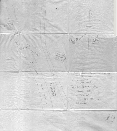
Cataloochee tract 217: Cataloochee School
GSMNP_02120_III-B-9207_a
Cataloochee tract 217: Cataloochee School
GSMNP_02120_III-B-9207_b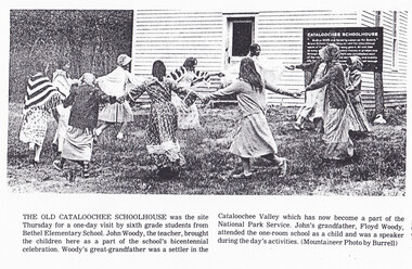
Cataloochee tract 217: Cataloochee School
GSMNP_Cata-217_News_03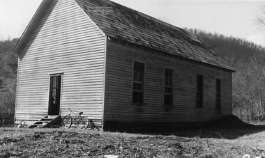
Cataloochee tract 217: Cataloochee School
GSMNP_02120_II-B-(6)-8007_a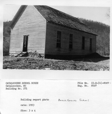
Cataloochee tract 217: Cataloochee School
GSMNP_02120_II-B-(6)-8007_b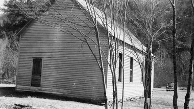
Cataloochee tract 217: Cataloochee School
GSMNP_02120_II-B-(6)-8008_a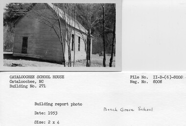
Cataloochee tract 217: Cataloochee School
GSMNP_02120_II-B-(6)-8008_b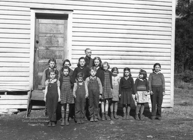
Cataloochee tract 217: Cataloochee School
GSMNP_02120_III-P-13299_a
Cataloochee tract 217: Cataloochee School
GSMNP_02120_III-P-13299_b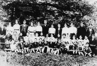
Cataloochee tract 217: Cataloochee School
GSMNP_02120_III-P-17814_a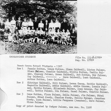
Cataloochee tract 217: Cataloochee School
GSMNP_02120_III-P-17814_b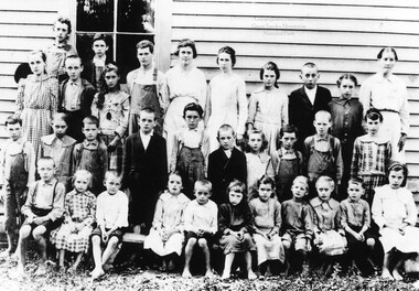
Cataloochee tract 217: Cataloochee School
GSMNP_02120_III-P-17815_a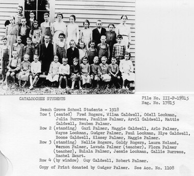
Cataloochee tract 217: Cataloochee School
GSMNP_02120_III-P-17815_b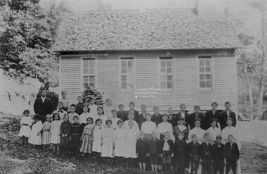
Cataloochee tract 217: Cataloochee School
GSMNP_02120_III-P-18356_a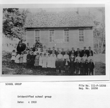
Cataloochee tract 217: Cataloochee School
GSMNP_02120_III-P-18356_b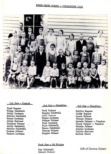
Cataloochee tract 217: Cataloochee School
GSMNP_Cata-217_Green_04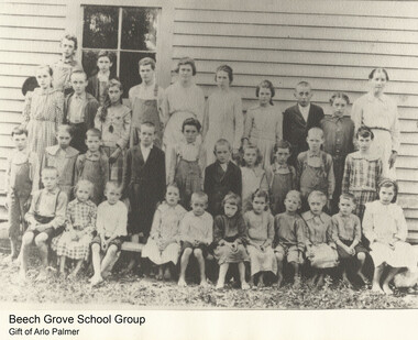
Cataloochee tract 217: Cataloochee School
GSMNP_Cata-217_Palmer_01Item’s are ‘child’ level descriptions to ‘parent’ objects, (e.g. one page of a whole book).
-
-
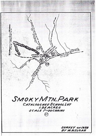
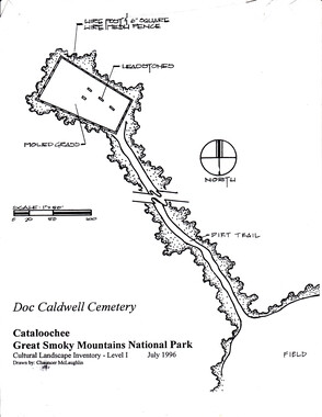
, .. CATALOOCHEE HISTORIC DISTRICT: CULTURAL LANDSCAPE REPORT GREAT SMOKY MOUNTAINS NATIONAL PARK January 2000 Dianne L. Flaugh Historical Landscape Architect Cultural Resources Resource Management Great Smoky Mountains National Park National Park Service CHAPTER 4: INDIVIDUAL TRACTS Beech Grove School Tract (217) Location Tract 217 is a 1.25-acre parcel located along the west bank of Palmer Creek near its juncture with Cataloochee Creek. Histozy 73 Originally this tract was part of a 150-acre parcel deeded to Jesse Palmer in 1857, from Love holdings. In 1896, Doc and Sarah Caldwell acquired 50 acres ofland from the estate of Jesse Palmer. Both Doc and Sarah Caldwell soon thereafter died, leaving the property to their young children. In April1906, the County Board of Education instructed "appraisers to lay off and condemn a site for a schoolhouse on lands belonging to the minor heirs of D. L. Caldwell ( deceased)."1 In 1907, the Board of Education paid $23.25 for the 1.25-acre tract.2 In 1930, the school lot was purchased by the NCPC for a sum of$1,325. From 1931, through 1952, the Haywood Board ofEducation leased the building for the purpose of conducting school. 3 Little is known ofthe early use of this parcel by Jesse Palmer and Doc Caldwell. The school tract is level bottomland and was likely cleared and farmed during their ownership. Beech Grove School was constructed to replace an earlier school, which had stood close to Rough Fork near Palmer Creek and along the old settler road. Little is known of the earlier school built some time between 1858 and 1900. Circa 1900, the school had become obsolete and Cataloochee residents made repeated pleas to the county school board to replace the building. After a final plea was ignored the school "accidentally" burned down and funds soon were approved for the construction of a new school. Actual construction {)[Beech Grove School began during the summer of 1907. Local residents donated trees for the lumber needed to construct the school. In 1906, a portable sawmill was brought into the valley and set up on the Andy Caldwell farm (Charles Ray Caldwell tract 213) to saw the lumber. 4 Following the last class to use the building in the 1950's, Beech Grove School was boarded up. By 1970, the building and grounds were being used as the Cataloochee Horse Camp, accommodating twenty-five to thirty horses. Although most users camped on the school grounds, during inclement weather access to the stove inside the building was offered. By the mid-1970s, the Haywood Trail Riders used the camp on a regular basis. Vegetation Survey drawings (ca. 193 5) and a ca. 1940 photograph of the school indicate that the grounds were kept cleared of trees in the area immediately surrounding the school building. A fence line separating the school lot from the adjacent Thomas Caldwell tract (212a) is clear of vegetation. The school grounds south of the building included at least four large maple and buckeye trees. Raymond Caldwell recalls that in the field north of 74 CULTURAL LANDSCAPE REPORT: CATALOOCHEE HISTORIC DISTRICT the school along Palmer Creek there was an orchard of twenty-five to thirty apple trees.5 The location of nine apple trees along the base ofthe slope was noted on survey drawings. Circulation The old settler road crossed Palmer Creek to run along Rough Fork in the front of the school building. Documented in survey drawings of the valley are two traces leading from the old settler road to connect in front of the school. Another path ran from the school front door toward a footbridge across Palmer Creek. Closer to Palmer Creek and Rough Fork, another road trace is depicted looping away from the main road. This may have provided access to the earlier school said to have stood at this location. Structures, Furnishings, and Objects NCPC records indicate that the property consisted of the lot and a 24' by 48' frame building (figure 23). In addition to the school building, a small structure, possibly a privy, is noted on the survey drawings along the property line and near Palmer Creek. Fencing is noted as extending along the property lines north and west of the school lot. None of the available photographs document the fencing type. View and Vistas Figure 23. Looking north toward Beech Grove School, ca. 1940. GRSM Archives. Open fence lines and open fields south and west of the school afforded excellent vi~ws to and from the school lot Existing Conditions The area of Beech Grove School is designated as an historic preservation area. The school building remains on site and opened as a historic interpretive exhibit ca. 1985. I I I • I I I I I I I I I I I I r _____/ I I I I i I I ~ ~ I I I I II il r- II_, CHAPTER 4: INDIVIDUAL TRACTS . 75 This function continues today. Today, the school building is situated in a small clearing (figure 24). The open space, which is dominated by fescue grass, is maintained through periodic mowing. The formerly open fence line southwest of the school is marked by a wide band of trees. This band oftrees blocks views to and from the school lot. Blackberries and other shrubs are growing inward from this tree line toward the building. Of the four large specimen trees noted in the survey drawings, one maple persists. No apple trees were found in the former orchard area north of the school. Figure 24. Beech Grove School, 1996. Note vegetation encroaching on school grounds. The circulation routes within the tract remain apparently unchanged. The route of the old settler road is unchanged in the southern end of the valley past this site. The traces leading off of the road to the existing school and site of the previous school building remain visible. A footpath leads from the school door toward Palmer Creek, however the footbridge is no longer in place. A NPS gravel parking area is located near the bridge across Palmer Creek at the head of one trace road leading to the school. Remnants ofwood post and wire fence extend along a Wet drainage on the west side ofthis tract. Also in this fence is a narrow wooden cattle gate. To the north, a linear depression, a line oftrees, along with fragments of woven wire fence mark the former fence line. Analysis and Evaluation ' This site is associated with community life in Cataloochee. Reforestation of fields north of the school lot and the loss of some small landscape elements have impacted the site. However, other elements of the landscape remain relatively unchanged including circulation, school structure, and situation in a clearing. Through its location the school lot conveys the practical nature of the community. The 76 CULTIJRAL LANDSCAPE REPORT: CATALOOCHEE HisTORIC DISTRICT site is located near the center of the Big Cataloochee Valley community and at the juncture of the settler road and the road along Palmer Creek. The historic condition ofthe site could be enhanced through the addition of some missing landscape elements such as fencing and a footbridge across Palmer Creek. Also the spread of shrubby plant material that is encroaching into the clearing should be controlled. Visual connections to the adjacent field could be restored through thinning and limbing up oftrees and brush along fence line. NOTES 1 Ed Trout, "Draft Cataloochee Historic Structure Reports:· Palmer Chapel, Beech Grove School, and Little Cataloochee Baptist Church," (Great Smoky Mountains National Park, [1989/90]), II . 2 Robert S. Lambert, Property ownership notes, GRSM Archives, Lambert 11-12. 3 Haywood County Board of Education lease file, GRMS Headquarters inactive file. 4 Trout, 12. 5 Raymond Caldwell, Interview by Jacqueline Lott and author, Written notes, Cataloochee, NC, 27 March 1998. .:·~ I I I I I I I I I I I I I I -
Object’s are ‘parent’ level descriptions to ‘children’ items, (e.g. a book with pages).
-
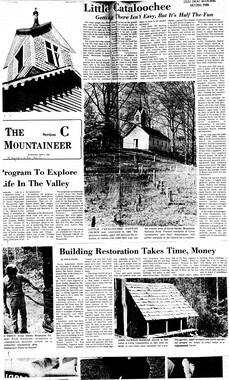
This 1.25-acre tract 217 in Cataloochee was owned by Cataloochee School. While, in general, the Great Smoky Mountains region was sparsely populated, the Cataloochee Valley remained an exception. By 1900, the population of Cataloochee had grown to 1,000 residents living in hundreds of log and frame homes. A few historic buildings have been preserved on site, including two churches, a school, several homes, and outbuildings. The North Carolina Park Commission was tasked with purchasing land for the Great Smoky Mountains National Park and people living in Cataloochee were among those displaced. Cataloochee families continue to return for annual reunions. In 2001, the National Park Service re-introduced elk into the valley.
-
Related items
-
Cataloochee tract 230: Ola Baptist Church Lot

-
Cataloochee tract owners
-
Cataloochee tract 215: George H. Caldwell

-
Cataloochee tract 296: Robert Palmer
-
Cataloochee tract 231: W. G. B. Messer

-
Cataloochee tract 235: R. J. Woody heirs

-
Cataloochee tract 254: W. D. Messer

-
Cataloochee tract 238 and 238a: D. H. Burris

-
Cataloochee tract 224: Jarvis L. Palmer

-
Cataloochee tract 219: Milia Palmer

-
Cataloochee tract 249: J. S. Woody

-
Cataloochee tract 206b: Lou Palmer King

-
Cataloochee tract owners

-
Cataloochee tract 212a: Thomas Caldwell
-
Senate 5518 report

-
Cataloochee tract 293: E. M. Messer

-
Cataloochee tract 230: Ola Baptist Church Lot
-
Cataloochee tract 226: W. M. Hall

-
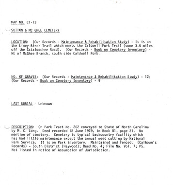
Cataloochee tract 202: M. C. Long
-
Cataloochee tract 225: Guy Pease

-
Cataloochee tract 230: Ola Baptist Church Lot
-
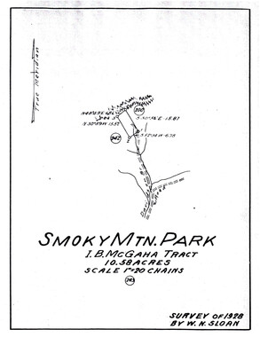
Cataloochee tract 243: I. B. McGaha
-
Cataloochee tract 244: John M. Palmer

-
Cataloochee tract 241 and 241a: Charles James Palmer

-
Cataloochee tract 217: Cataloochee School

-
Senatorial Committee meeting report
-
Cataloochee tract 213: Charles Ray Caldwell

-
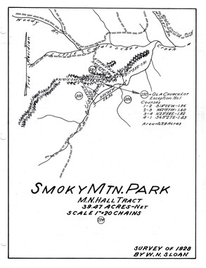
Cataloochee tract 229: M. N. Hall

-
Cataloochee tract 289: Spence Phillips

-
Cataloochee tract 296: Robert Palmer

-
Cataloochee tract 212a: Thomas Caldwell
-
Cataloochee tract 218: Palmer's Chapel Church

Part of Collection
Great Smoky Mountains - A Park for America
-
Pulp Made Where the Wood Grows!

-
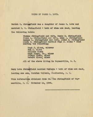
Love family heirs: James R. Love
-
Appalachian National Park Association Newspaper Clippings, 1899-1902

-
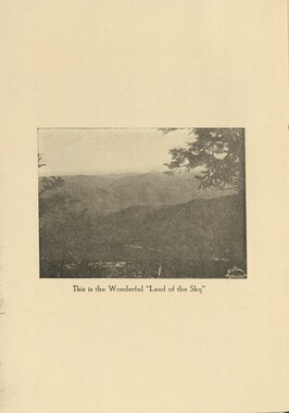
Report of the Secretary of Agriculture in relation to the forests, rivers, and mountains of the southern Appalachian region

-
Horace Kephart preferred life in a mountain camp
-
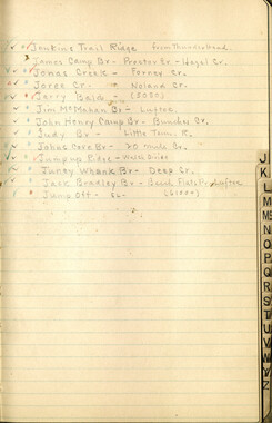
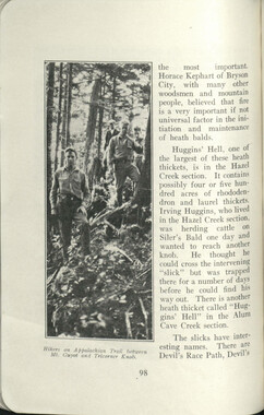
Hikers camp

-
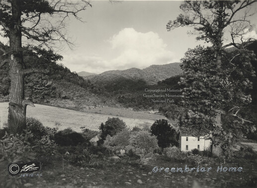
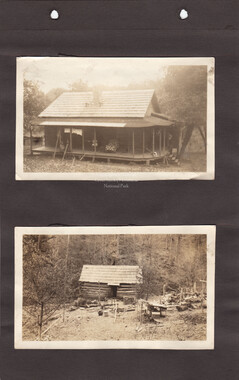
Greenbriar Home
-
Appalachian National Park Association Newspaper Clippings, 1902-1907, 1925, 1928
-
Cataloochee tract 206b: Lou Palmer King
-
Source material for a study of the Great Smokies
-
Nomenclature notebook: N.C. portion/ Great Smoky Mountains National Park
-
Wilburn photograph album
-
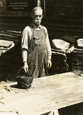
Milas Messer tanning leather
-
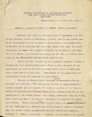
Minutes of Meetings of the Appalachian National Park Association

-
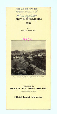
Trips in the Smokies, 1930
-
Floreen or the Story of Mitchell
-
Appalachian National Park Association Newspaper Clippings, 1902-1907, 1925, 1928

-
Save our Mountains

-
Editorials commenting on the Appalachian National Park movement
-
Hardwood Bark, 1922

-
Handbook/ 1933/ Smoky Mountains Hiking Club

-
Cataloochee tract 231: W. G. B. Messer

-
Report of the Secretary of Agriculture in relation to the forests, rivers, and mountains of the southern Appalachian region
-
Appalachian Trail Club bulletin
-
Appalachian National Park Association Newspaper Clippings, 1899-1902

-
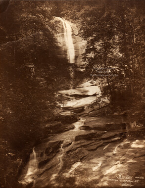
Silver Falls
-
Hardwood Bark, 1929

-
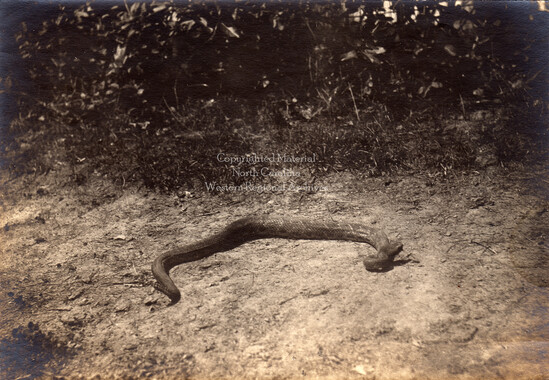
Rattlesnake
-
Guide to the Great Smoky Mountains National Park
-
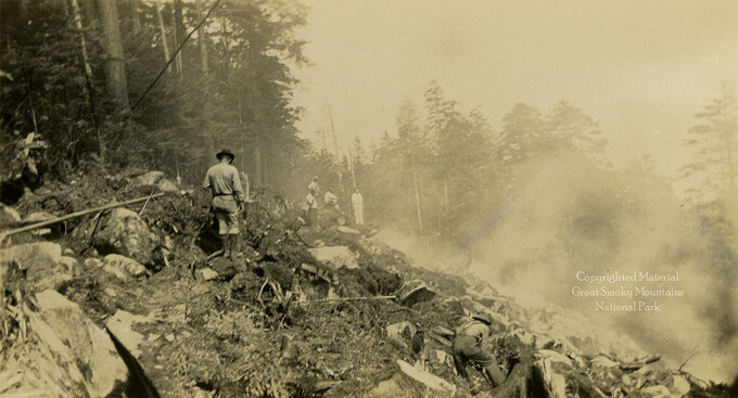
Roadway construction: workers
-
Resolution circulated by the DAR

-
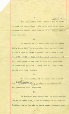
By-laws of the Appalachian National Park Association