- Canton Champion Fibre Company (2308)
- Cherokee Traditions (292)
- Civil War in Southern Appalachia (165)
- Craft Revival (1942)
- Great Smoky Mountains - A Park for America (2766)
- Highlights from Western Carolina University (430)
- Horace Kephart (941)
- Journeys Through Jackson (154)
- LGBTQIA+ Archive of Jackson County (81)
- Oral Histories of Western North Carolina (314)
- Picturing Appalachia (6772)
- Stories of Mountain Folk (413)
- Travel Western North Carolina (160)
- Western Carolina University Fine Art Museum Vitreograph Collection (129)
- Western Carolina University Herbarium (92)
- Western Carolina University: Making Memories (708)
- Western Carolina University Publications (2283)
- Western Carolina University Restricted Electronic Theses and Dissertations (146)
- Western North Carolina Regional Maps (71)
- World War II in Southern Appalachia (131)
- Allanstand Cottage Industries (62)
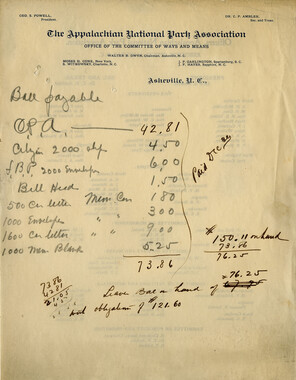
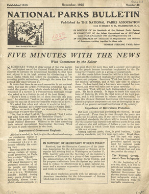
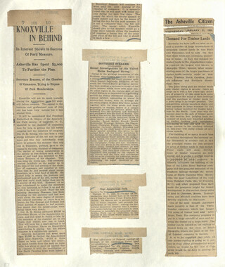
- Appalachian National Park Association (53)
- Bennett, Kelly, 1890-1974 (1388)
- Berry, Walter (76)
- Brasstown Carvers (40)
- Carver, George Washington, 1864?-1943 (26)
- Cathey, Joseph, 1803-1874 (1)
- Champion Fibre Company (233)
- Champion Paper and Fibre Company (297)
- Cherokee Indian Fair Association (16)
- Cherokee Language Program (22)
- Crowe, Amanda (40)
- Edmonston, Thomas Benton, 1842-1907 (7)
- Ensley, A. L. (Abraham Lincoln), 1865-1948 (275)
- Fromer, Irving Rhodes, 1913-1994 (70)
- George Butz (BFS 1907) (46)
- Goodrich, Frances Louisa (120)
- Grant, George Alexander, 1891-1964 (96)
- Heard, Marian Gladys (60)
- Kephart, Calvin, 1883-1969 (15)
- Kephart, Horace, 1862-1931 (313)
- Kephart, Laura, 1862-1954 (39)
- Laney, Gideon Thomas, 1889-1976 (439)
- Masa, George, 1881-1933 (61)
- McElhinney, William Julian, 1896-1953 (44)
- Niggli, Josephina, 1910-1983 (10)
- North Carolina Park Commission (105)
- Osborne, Kezia Stradley (9)
- Owens, Samuel Robert, 1918-1995 (11)
- Penland Weavers and Potters (36)
- Roberts, Vivienne (15)
- Roth, Albert, 1890-1974 (142)
- Schenck, Carl Alwin, 1868-1955 (1)
- Sherrill's Photography Studio (2565)
- Southern Highland Handicraft Guild (127)
- Southern Highlanders, Inc. (71)
- Stalcup, Jesse Bryson (46)
- Stearns, I. K. (213)
- Thompson, James Edward, 1880-1976 (226)
- United States. Indian Arts and Crafts Board (130)
- USFS (683)
- Vance, Zebulon Baird, 1830-1894 (1)
- Weaver, Zebulon, 1872-1948 (58)
- Western Carolina College (230)
- Western Carolina Teachers College (282)
- Western Carolina University (1794)
- Western Carolina University. Mountain Heritage Center (18)
- Whitman, Walt, 1819-1892 (10)
- Wilburn, Hiram Coleman, 1880-1967 (73)
- Williams, Isadora (3)
- Cain, Doreyl Ammons (0)
- Crittenden, Lorraine (0)
- Rhodes, Judy (0)
- Smith, Edward Clark (0)
- Appalachian Region, Southern (2568)
- Asheville (N.C.) (1917)
- Avery County (N.C.) (26)
- Blount County (Tenn.) (161)
- Buncombe County (N.C.) (1671)
- Cherokee County (N.C.) (283)
- Clay County (N.C.) (555)
- Graham County (N.C.) (233)
- Great Smoky Mountains National Park (N.C. and Tenn.) (514)
- Haywood County (N.C.) (3523)
- Henderson County (N.C.) (70)
- Jackson County (N.C.) (4694)
- Knox County (Tenn.) (25)
- Knoxville (Tenn.) (12)
- Lake Santeetlah (N.C.) (10)
- Macon County (N.C.) (420)
- Madison County (N.C.) (211)
- McDowell County (N.C.) (39)
- Mitchell County (N.C.) (132)
- Polk County (N.C.) (35)
- Qualla Boundary (981)
- Rutherford County (N.C.) (76)
- Swain County (N.C.) (2114)
- Transylvania County (N.C.) (270)
- Watauga County (N.C.) (12)
- Waynesville (N.C.) (74)
- Yancey County (N.C.) (72)
- Aerial Photographs (3)
- Aerial Views (60)
- Albums (books) (4)
- Articles (1)
- Artifacts (object Genre) (228)
- Bibliographies (1)
- Biography (general Genre) (2)
- Cards (information Artifacts) (38)
- Clippings (information Artifacts) (191)
- Crafts (art Genres) (622)
- Depictions (visual Works) (21)
- Design Drawings (1)
- Drawings (visual Works) (184)
- Envelopes (73)
- Facsimiles (reproductions) (1)
- Fiction (general Genre) (4)
- Financial Records (12)
- Fliers (printed Matter) (67)
- Glass Plate Negatives (381)
- Guidebooks (2)
- Internegatives (10)
- Interviews (815)
- Land Surveys (102)
- Letters (correspondence) (1013)
- Manuscripts (documents) (618)
- Maps (documents) (177)
- Memorandums (25)
- Minutes (administrative Records) (59)
- Negatives (photographs) (5835)
- Newsletters (1285)
- Newspapers (2)
- Occupation Currency (1)
- Paintings (visual Works) (1)
- Pen And Ink Drawings (1)
- Periodicals (193)
- Personal Narratives (10)
- Photographs (12976)
- Plans (maps) (1)
- Poetry (6)
- Portraits (1960)
- Postcards (329)
- Programs (documents) (151)
- Publications (documents) (2236)
- Questionnaires (65)
- Scrapbooks (282)
- Sheet Music (2)
- Slides (photographs) (402)
- Songs (musical Compositions) (2)
- Sound Recordings (796)
- Specimens (92)
- Speeches (documents) (15)
- Tintypes (photographs) (8)
- Transcripts (322)
- Video Recordings (physical Artifacts) (23)
- Vitreographs (129)
- Text Messages (0)
- A.L. Ensley Collection (275)
- Appalachian Industrial School Records (7)
- Appalachian National Park Association Records (336)
- Axley-Meroney Collection (2)
- Bayard Wootten Photograph Collection (20)
- Bethel Rural Community Organization Collection (7)
- Blumer Collection (5)
- C.W. Slagle Collection (20)
- Canton Area Historical Museum (2110)
- Carlos C. Campbell Collection (282)
- Cataloochee History Project (64)
- Cherokee Studies Collection (4)
- Daisy Dame Photograph Album (5)
- Daniel Boone VI Collection (1)
- Doris Ulmann Photograph Collection (112)
- Elizabeth H. Lasley Collection (1)
- Elizabeth Woolworth Szold Fleharty Collection (4)
- Frank Fry Collection (95)
- George Masa Collection (173)
- Gideon Laney Collection (452)
- Hazel Scarborough Collection (2)
- Hiram C. Wilburn Papers (28)
- Historic Photographs Collection (236)
- Horace Kephart Collection (861)
- Humbard Collection (33)
- Hunter and Weaver Families Collection (1)
- I. D. Blumenthal Collection (4)
- Isadora Williams Collection (4)
- Jesse Bryson Stalcup Collection (47)
- Jim Thompson Collection (224)
- John B. Battle Collection (7)
- John C. Campbell Folk School Records (80)
- John Parris Collection (6)
- Judaculla Rock project (2)
- Kelly Bennett Collection (1407)
- Love Family Papers (11)
- Major Wiley Parris Civil War Letters (3)
- Map Collection (12)
- McFee-Misemer Civil War Letters (34)
- Mountain Heritage Center Collection (4)
- Norburn - Robertson - Thomson Families Collection (44)
- Pauline Hood Collection (7)
- Pre-Guild Collection (2)
- Qualla Arts and Crafts Mutual Collection (12)
- R.A. Romanes Collection (681)
- Rosser H. Taylor Collection (1)
- Samuel Robert Owens Collection (94)
- Sara Madison Collection (144)
- Sherrill Studio Photo Collection (2558)
- Smoky Mountains Hiking Club Collection (616)
- Stories of Mountain Folk - Radio Programs (374)
- The Reporter, Western Carolina University (510)
- Venoy and Elizabeth Reed Collection (16)
- WCU Gender and Sexuality Oral History Project (32)
- WCU Mountain Heritage Center Oral Histories (25)
- WCU Oral History Collection - Mountain People, Mountain Lives (71)
- WCU Students Newspapers Collection (1744)
- Western North Carolina Tomorrow Black Oral History Project (69)
- William Williams Stringfield Collection (2)
- Zebulon Weaver Collection (109)
- African Americans (390)
- Appalachian Trail (35)
- Artisans (521)
- Cherokee art (84)
- Cherokee artists -- North Carolina (10)
- Cherokee language (21)
- Cherokee pottery (101)
- Cherokee women (208)
- Church buildings (167)
- Civilian Conservation Corps (U.S.) (110)
- College student newspapers and periodicals (1830)
- Dams (103)
- Dance (1023)
- Education (222)
- Floods (61)
- Folk music (1015)
- Forced removal, 1813-1903 (2)
- Forest conservation (220)
- Forests and forestry (1105)
- Gender nonconformity (4)
- Great Smoky Mountains National Park (N.C. and Tenn.) (181)
- Hunting (38)
- Landscape photography (25)
- Logging (117)
- Maps (83)
- Mines and mineral resources (8)
- North Carolina -- Maps (18)
- Paper industry (38)
- Postcards (255)
- Pottery (135)
- Railroad trains (71)
- Rural electrification -- North Carolina, Western (3)
- School integration -- Southern States (2)
- Segregation -- North Carolina, Western (5)
- Slavery (5)
- Sports (452)
- Storytelling (244)
- Waterfalls -- Great Smoky Mountains (N.C. and Tenn.) (66)
- Weaving -- Appalachian Region, Southern (280)
- Wood-carving -- Appalachian Region, Southern (328)
- World War, 1939-1945 (173)
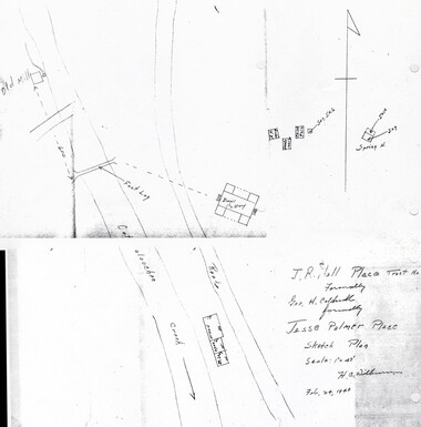
Cataloochee tract 216: J. R. Hall


Cataloochee tract 216: J. R. Hall
GSMNP_80235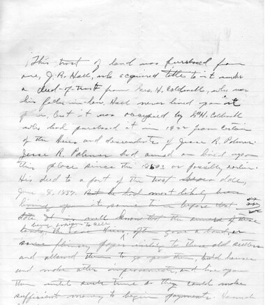
Cataloochee tract 216: J. R. Hall
GSMNP_02120_III-B-9207_a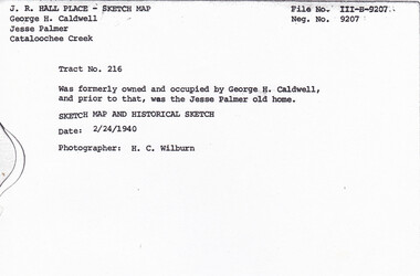
Cataloochee tract 216: J. R. Hall
GSMNP_02120_III-B-9207_b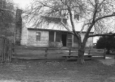
Cataloochee tract 216: J. R. Hall
GSMNP_02120_III-B-10481_a
Cataloochee tract 216: J. R. Hall
GSMNP_02120_III-B-10481_b
Cataloochee tract 216: J. R. Hall
GSMNP_02120_III-M-9131_a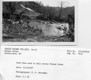
Cataloochee tract 216: J. R. Hall
GSMNP_02120_III-M-9131_b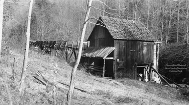
Cataloochee tract 216: J. R. Hall
GSMNP_02120_III-M-9132_a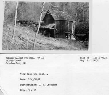
Cataloochee tract 216: J. R. Hall
GSMNP_02120_III-M-9132_b
Cataloochee tract 216: J. R. Hall
GSMNP_02120_III-M-9132_c
Cataloochee tract 216: J. R. Hall
GSMNP_02120_III-M-9133_a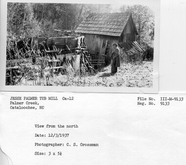
Cataloochee tract 216: J. R. Hall
GSMNP_02120_III-M-9133_b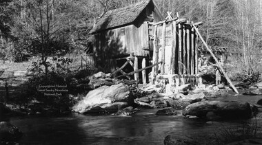
Cataloochee tract 216: J. R. Hall
GSMNP_02120_III-M-9134_a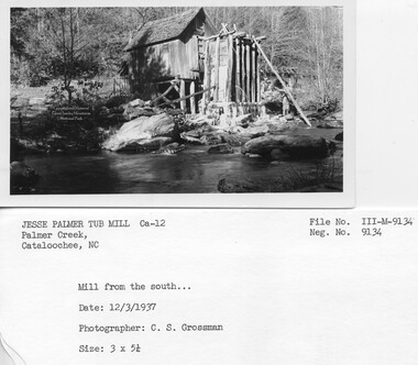
Cataloochee tract 216: J. R. Hall
GSMNP_02120_III-M-9134_b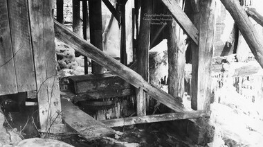
Cataloochee tract 216: J. R. Hall
GSMNP_02120_III-M-9135_a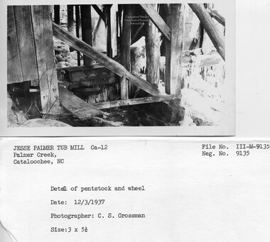
Cataloochee tract 216: J. R. Hall
GSMNP_02120_III-M-9135_b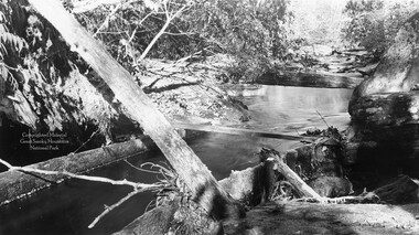
Cataloochee tract 216: J. R. Hall
GSMNP_02120_III-M-9137_a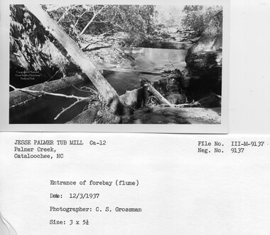
Cataloochee tract 216: J. R. Hall
GSMNP_02120_III-M-9137_b
Cataloochee tract 216: J. R. Hall
GSMNP_02120_III-M-9138_a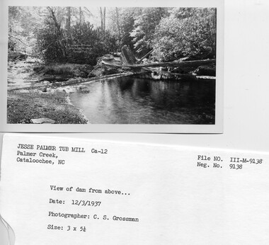
Cataloochee tract 216: J. R. Hall
GSMNP_02120_III-M-9138_b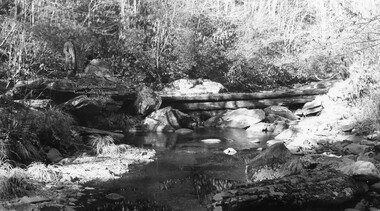
Cataloochee tract 216: J. R. Hall
GSMNP_02120_III-M-9139_a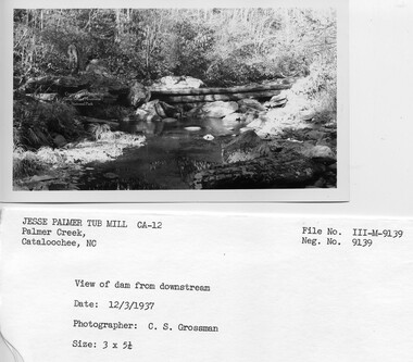
Cataloochee tract 216: J. R. Hall
GSMNP_02120_III-M-9139_b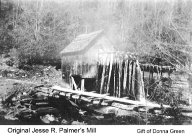
Cataloochee tract 216: J. R. Hall
GSMNP_Cata-216_Green_01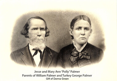
Cataloochee tract 216: J. R. Hall
GSMNP_Cata-216_Green_09Item’s are ‘child’ level descriptions to ‘parent’ objects, (e.g. one page of a whole book).
-
-
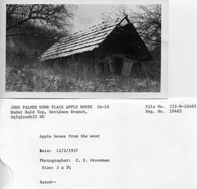
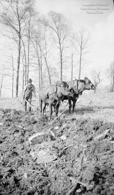
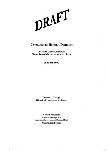
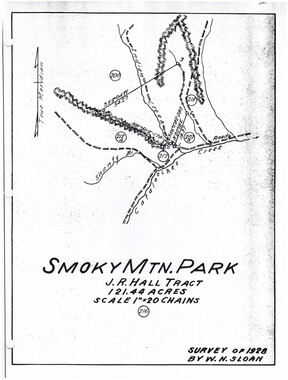
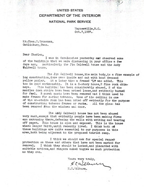
CATALOOCHEE HISTORIC DISTRICT: CULTURAL LANDSCAPE REPORT GREAT SMOKY MOUNTAINS NATIONAL PARK January 2000 Dianne L. Flaugh Historical Landscape Architect Cultural Resources Resource Management Great Smoky Mountains National Park National Park Service CHAPTER 4: INDIVIDUAL TRACTS Jesse Palmer Tract (216) Location Tract 216 is. a 121.44-acre parcel located along Palmer Creek near its juncture with Cataloochee Creek. Land from this tract lies on both sides ofPalmer Creek. History 115 Jesse Palmer acquired from the Love holdings two adjoining tracts, one hundred fifty acres in 1857, and four hundred acres in 1875. In 1896, the properties were divided among his heirs with one eighty-five acre lot going to his son Thomas. In 1901, Thomas Palmer inherited another fifty-five acre lot from his mother, Polly Ann Palmer. Thomas died in 1922, and his widow sold one hundred twenty-five acres of land to George H. Caldwell. This land then passed to W. G. Hall ( 1924 ), tnistee for J. R. Hall; and then to 1. R. Hall (1928). Although the property is shown as owned by Hall, Jarvis Caldwell occupied the property from 1922, untill938. The NCPC purchased the tract from J. R. Hall in 1930, for $4,000. Although few specifics are known of Jesse Palmer's agricultural activities, the 1860 Agricultural Census show that he had twenty acres of improved land. Crops included com, rye, oats, tobacco, potatoes, hay, and sorghum. His livestock included hOrses, oxen, milk cows, cattle, sheep, and swine. By 1870, he had double the amount of cleared land growing many ofthe same crops. In 1880, the Palmer household had grown to number seventeen people including Jesse, Polly Ann, five sons, eight daughters, and two servants.1 Jesse also owned over seven hundred acres ofland of which over one hundred acres was tilled or meadow. He also had two acres of apple and peach trees. It is likely that some of these fruit trees were found on this tract. ~ While, little is known of the use of this land by omas Caldwel it is likely that he continued to farm portions of it, especially the leve em-lrurd:-tease records show that parts ofthe tract were farmed until1943. The gristmill built by John Mull (ca. 1860s) for the Loves was located along the west bank of Palmer Creek on this tract and apparently was operated by Jesse Palmer. A tub mill built by Vick Smith (ca. 1908) for Thomas Palmer replaced the Mull mill. This later mill stood approximately sixty to one hundred yards below the Mull mill. After the death of Thomas Palmer, Jarvis CaldwelF lived on the property and operated the mill until moving out in 1938. Following Jarvis Caldwell, Lush Caldwell operated the mill until it was tom down in 1942/45.3 A water-powered sash saw, known as the Jesse Palmer sash saw, stood near the gristmill. It is unknown if Mull or Palmer built the sash saw. In interviews with H. C. Wilburn, both Steve Woody and Turkey George Palmer indicated they built their homes with lumber sawn on the Palmer sash saw. Steve Woody claimed to build his home in 1880, while Turkey George indicated a construction date of 1890, for his home. By the time the park was established sash sawmills were obsolete, replaced by steam powered 116 CULTIJRAL LANDSCAPE REPORT: CATALOOCHEE HJSTORIC DISTRICT portable mills. By the 1930s the Palmer sash saw, found upstream from the tubmill, stood in ruins. 4 Vegetation There are no NCPC records to indicate the amount of land considered to be cultivated fields, pastures or woodland at the time of purchase. Survey drawings (ca. 193 5 and 1940) indicate that the bottomland was open on both sides of Palmer Creek. The survey drawings also note a line of apple trees planted at the base of the slope on the west side ofPalmer Creek above the school lot. Ray Caldwell recalls that twenty-five to thirty apple trees once stood at this location.5 The survey drawings also note the location of several specimen walnut trees and sycamore trees in one of the field areas. Multiple drainage ways in this field area would have made this area difficult to cultivate, and it was probably used as pasture. In 1942, Park records indicate that CCC workers began planting trees in the proposed campground area. This campground would have been on the east side of Palmer Creek on what was the Jesse Palmer (216) and D. Caldwell (207a) tracts. Circulation A trace road extended along the east bank of Palmer Creek. This provided access to the Jesse Palmer homesite and other homesites up Davidson Branch and Pretty Hollow Creek. CCC workers (ca. 1934-1938) improved 1.2 miles of this road above the Palmer homesite for fire protection purposes. While the farmstead was located on the east bank of Palmer Creek, the gristmill was on the west bank above the farmstead. A ford and footlog provided access to the opposite bank (figure 41). Structures, Furnishings, and Objects Figure 41. Ford from mill to Jesse Palmer house, 1937. GRSM Archives. Records indicate that the property included a log house, applehouse, springhouse, chicken house, shop and garage, barn, and gristmill. Except for a brief description of the tubmill, no building survey information describing these structures has been found. The CHAPTER 4: INDIVIDUAL TRACTS I 17 house and outbuildings were destroyed by the NPS about 1945. The tubmill stood on the opposite side of Palmer Creek approximately six hundred feet north of the house (figure 42). A footlog and ford provided access to the millsite. The frame mill building stood on wood piers, was sided with vertical boards and roofed with wooden shingles. A long mill race lead from the log dam across Palmer Creek to the fore bay. This millrace was constructed of planks and supported by wood piers. Figure 42 . Palmer tubmill, ca. 1930. Courtesy Ray Caldwell, GRSM Archives. The house was reportedly built by Jesse Palmer (ca. 1860)~ and consisted oftwo log pens connected by a dogtrot. Later the dogtrot was enclosed, a dormer added and the structure covered with weatherboarding. Twin field stone chimneys stood at the east and west ends ofthe house. Photographs (ca. 1930) show the house yard encircled with fence. A narrow wooden gate broke the fence line and a fieldstone walk led to the front door. An evergreen shrub stood to the east of the walk and fruit trees stood nearby the house. Ray 118 CULTIJRAL LANDSCAPE REPORT: CATALOOCHEE HISTORIC DISTRICT Caldwell recalls that a kitchen garden surrounded by high palen fence stood at the west end of the house and that bee gums stood at the east end of the house (figure 43).6 Figure 43. Jesse Palmer house, ca. 1930. Wilburn Photo Album, GRSM Archives. In 1933, a fire burned the Palmer bam to the ground.7 A replacement bam was built on the tract and the location of this bam is noted on site drawings by Wilburn (ca. 1940) and topographical survey drawings (ca. 1940). This bam appears to still stand in 1953 aerial photographs of Cataloochee. Ray Caldwell also recalls that th~ shop and garage found along Palmer Creek housed a blacksmith shop. The Caldwell family also had a sorghum mill near this building that they had moved from the George Caldwell tract 215 along Shanty Branch.8 Survey drawings (ca. 1935 and 1940) of the valley show that the level valley floor was divided into several field areas separated by fencing. It also notes the location of an · underground drain leading away from the springhouse. This field drain is remembered by Ray Caldwell and described as being constructed of stone. A rock wall five feet high and four feet wide extended four hundred feet along the road leading to the Palmer house. In 1940, this wall was crushed and used by CCC crews in road construction.9 Existing Conditions The area of the Jesse Palmer homesite is included in the area designated forhistoric landscape management. It currently functions as an NPS overnight horsecamp. This camp was constructed in the late 1970s. Minimal facilities are provided and include comfort stations, hitching posts, stalls, and a manure collection point. Except for small open areas in the horsecamp, this tract has entirely reforested. Tulip poplar and white pine dominate some areas ofthe-tract, indicating that these areas were once open. 10 A pl<i.nted stand oftrees consisting ofthree rows ofred maple and five_rows of hemlock is also found in the bottomland of this tract. 1997 core samples of these closely planted trees show them to be approximately forty-five years old. Two of the specimen walnut trees noted on the survey drawings remain. The original route along Palmer Creek continues to be used for access to the horsecamp. An NPS gate at the upper end of the horsecamp blocks vehicular traffic CHAPTER 4: INDIVIDUAL TRACTS 119 beyond that point. Palmer Creek Trail, Pretty Hollow Gap Trail, and Little Cataloochee Trail can all be accessed from the trail extending up Palmer Creek. Low remnants of a rock wall can be seen at places along this road. None of the structures remain on site. Chimney piles, stone walkway, and cedar tree remain to mark the homesite location. One mature apple tree stands south of the homesite. The locations of the applehouse, springhouse, and chicken house can all be identified by foundation remnants. Stone piles and remnant wood posts can also be found in the field areas south of the homesite. On the west side of Palmer Creek above the homesite, a one to two foot high stone wall extends approximately one hundred along Palmer Creek. The millsite is found north of this wall and marked by ground topography and metal artifacts. Extending north from the millsite to the log dam, which still spans Palmer Creek, are two traces that remain clear of trees. The trace nearer the creek is rocky and is probably the path taken by the millrace. Analysis and Evaluation This site is associated with the Palmer family, early settlement, and community services in the form of gristmills and sawmill. While impacted by reforestation, the removal ofbuildings, and its current use, features of the historic landscape remain evident. The setting in a narrow cove along Palmer Creek and structural remnants found at the foot of steep slopes reflect the difficulty of farming and importance of level farm land. The gristmill was located on a narrow piece of levelland on the opposite side of Palmer Creek. This location also illustrates the settlers' maximization of level land. The dam, found upstream from the millsite, is evident as a remnant of the Palmer mill that once played an important role in the Cataloochee community. NOTES 1 The family included William,23; George, 21; Mary, 20; Robert, 18; Julia, 17; Margaret, 16; Sarah, 14; J. Frank. 12; Elizabeth, 10; Burdine, 8; Rachael, 6; Thomas, 4; Ellen, 2. Two additional household members were listed as servants. They were James Chambers and James Noland, both 19. 2 Jarvis Caldwell was the son of George Caldwell, who purchased the property in 1922. 3 Ray Caldwell, Interview by Jacqueline Lott, Written notes, Cataloochee, NC, 8 January 1997. 4 Hiram Wilburn, Interview notes, R C. Wilburn Papers, Special Collections, Hunter Library, Western North Carolina University, Cullowhee, NC, 48, 51; Historic American Building Survey Note Cards, Jesse Palmer Place - Tubmill, [1935/37], photocopy. 5 Ray Caldwell, Interview by Jacqueline Lott and author, Written notes, Cataloochee, NC, 27 March 1998. 6 Ibid. 7 John Needham, "North Carolina Division Monthly Reports," January 1933, GRSM Headquarters inactive files. 1 Ray Caldwell, 27 March 1998. 9 Ibid., and Hiram Wilburn memorandum to the Superintendent, 11 June 1940, R C. Wilburn Papers, Folder 13, Special Collections, Hunter Library, Western North Carolina University, Cullowhee, NC. 120 CULn.JRAL LANDSCAPE REPORT: CATALOOCHEE HISTORIC DISTRICT 10 "A Vegetation Survey of Cultural Management Zones in the Cataloochee Area of the Great Smoky Mountains National Park," Great Smoky Mountains National Park, Resource Management, 6 May 1997, 34-36.
Object’s are ‘parent’ level descriptions to ‘children’ items, (e.g. a book with pages).
-
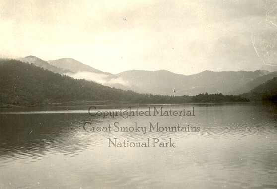
This 121.5-acre tract 216 in Cataloochee was owned by J. R. Hall. While, in general, the Great Smoky Mountains region was sparsely populated, the Cataloochee Valley remained an exception. By 1900, the population of Cataloochee had grown to 1,000 residents living in hundreds of log and frame homes. A few historic buildings have been preserved on site, including two churches, a school, several homes, and outbuildings. The North Carolina Park Commission was tasked with purchasing land for the Great Smoky Mountains National Park and people living in Cataloochee were among those displaced. Cataloochee families continue to return for annual reunions. In 2001, the National Park Service re-introduced elk into the valley.
-


Part of Collection
Great Smoky Mountains - A Park for America