- Canton Champion Fibre Company (2308)
- Cherokee Traditions (293)
- Civil War in Southern Appalachia (165)
- Craft Revival (1942)
- Great Smoky Mountains - A Park for America (2767)
- Highlights from Western Carolina University (430)
- Horace Kephart (941)
- Journeys Through Jackson (154)
- LGBTQIA+ Archive of Jackson County (24)
- Oral Histories of Western North Carolina (314)
- Picturing Appalachia (6772)
- Stories of Mountain Folk (413)
- Travel Western North Carolina (160)
- Western Carolina University Fine Art Museum Vitreograph Collection (129)
- Western Carolina University Herbarium (92)
- Western Carolina University: Making Memories (708)
- Western Carolina University Publications (2283)
- Western Carolina University Restricted Electronic Theses and Dissertations (146)
- Western North Carolina Regional Maps (71)
- World War II in Southern Appalachia (131)
- Appalachian National Park Association (53)
- Berry, Walter (76)
- Champion Fibre Company (5)
- Fromer, Irving Rhodes, 1913-1994 (70)
- Grant, George Alexander, 1891-1964 (96)
- Kephart, Horace, 1862-1931 (23)
- Masa, George, 1881-1933 (17)
- North Carolina Park Commission (105)
- Roth, Albert, 1890-1974 (142)
- Schenck, Carl Alwin, 1868-1955 (1)
- Stearns, I. K. (2)
- Thompson, James Edward, 1880-1976 (45)
- Weaver, Zebulon, 1872-1948 (55)
- Wilburn, Hiram Coleman, 1880-1967 (72)
- Allanstand Cottage Industries (0)
- Bennett, Kelly, 1890-1974 (0)
- Brasstown Carvers (0)
- Cain, Doreyl Ammons (0)
- Carver, George Washington, 1864?-1943 (0)
- Cathey, Joseph, 1803-1874 (0)
- Champion Paper and Fibre Company (0)
- Cherokee Indian Fair Association (0)
- Cherokee Language Program (0)
- Crittenden, Lorraine (0)
- Crowe, Amanda (0)
- Edmonston, Thomas Benton, 1842-1907 (0)
- Ensley, A. L. (Abraham Lincoln), 1865-1948 (0)
- George Butz (BFS 1907) (0)
- Goodrich, Frances Louisa (0)
- Heard, Marian Gladys (0)
- Kephart, Calvin, 1883-1969 (0)
- Kephart, Laura, 1862-1954 (0)
- Laney, Gideon Thomas, 1889-1976 (0)
- McElhinney, William Julian, 1896-1953 (0)
- Niggli, Josephina, 1910-1983 (0)
- Osborne, Kezia Stradley (0)
- Owens, Samuel Robert, 1918-1995 (0)
- Penland Weavers and Potters (0)
- Rhodes, Judy (0)
- Roberts, Vivienne (0)
- Sherrill's Photography Studio (0)
- Smith, Edward Clark (0)
- Southern Highland Handicraft Guild (0)
- Southern Highlanders, Inc. (0)
- Stalcup, Jesse Bryson (0)
- United States. Indian Arts and Crafts Board (0)
- USFS (0)
- Vance, Zebulon Baird, 1830-1894 (0)
- Western Carolina College (0)
- Western Carolina Teachers College (0)
- Western Carolina University (0)
- Western Carolina University. Mountain Heritage Center (0)
- Whitman, Walt, 1819-1892 (0)
- Williams, Isadora (0)
- 1810s (1)
- 1840s (1)
- 1850s (2)
- 1860s (3)
- 1870s (4)
- 1880s (7)
- 1890s (64)
- 1900s (294)
- 1910s (227)
- 1920s (461)
- 1930s (1585)
- 1940s (82)
- 1950s (15)
- 1960s (13)
- 1970s (47)
- 1980s (14)
- 1990s (17)
- 2000s (31)
- 2010s (1)
- 1600s (0)
- 1700s (0)
- 1800s (0)
- 1820s (0)
- 1830s (0)
- 2020s (0)
- Appalachian Region, Southern (80)
- Asheville (N.C.) (1)
- Avery County (N.C.) (6)
- Blount County (Tenn.) (159)
- Buncombe County (N.C.) (204)
- Cherokee County (N.C.) (10)
- Clay County (N.C.) (3)
- Graham County (N.C.) (108)
- Great Smoky Mountains National Park (N.C. and Tenn.) (416)
- Haywood County (N.C.) (263)
- Henderson County (N.C.) (13)
- Jackson County (N.C.) (58)
- Knox County (Tenn.) (21)
- Knoxville (Tenn.) (11)
- Lake Santeetlah (N.C.) (10)
- Macon County (N.C.) (25)
- Madison County (N.C.) (14)
- McDowell County (N.C.) (5)
- Mitchell County (N.C.) (7)
- Polk County (N.C.) (2)
- Qualla Boundary (22)
- Rutherford County (N.C.) (16)
- Swain County (N.C.) (516)
- Transylvania County (N.C.) (36)
- Watauga County (N.C.) (2)
- Waynesville (N.C.) (2)
- Yancey County (N.C.) (34)
- Aerial Views (3)
- Articles (1)
- Artifacts (object Genre) (4)
- Clippings (information Artifacts) (77)
- Drawings (visual Works) (174)
- Envelopes (2)
- Financial Records (9)
- Fliers (printed Matter) (34)
- Guidebooks (1)
- Interviews (11)
- Land Surveys (102)
- Letters (correspondence) (219)
- Manuscripts (documents) (91)
- Maps (documents) (69)
- Memorandums (14)
- Minutes (administrative Records) (20)
- Negatives (photographs) (282)
- Newsletters (12)
- Paintings (visual Works) (1)
- Pen And Ink Drawings (1)
- Photographs (1657)
- Portraits (39)
- Postcards (15)
- Publications (documents) (107)
- Scrapbooks (3)
- Sound Recordings (7)
- Speeches (documents) (11)
- Transcripts (46)
- Aerial Photographs (0)
- Albums (books) (0)
- Biography (general Genre) (0)
- Cards (information Artifacts) (0)
- Crafts (art Genres) (0)
- Depictions (visual Works) (0)
- Design Drawings (0)
- Facsimiles (reproductions) (0)
- Fiction (general Genre) (0)
- Glass Plate Negatives (0)
- Internegatives (0)
- Newspapers (0)
- Occupation Currency (0)
- Periodicals (0)
- Personal Narratives (0)
- Plans (maps) (0)
- Poetry (0)
- Programs (documents) (0)
- Questionnaires (0)
- Sheet Music (0)
- Slides (photographs) (0)
- Specimens (0)
- Text Messages (0)
- Tintypes (photographs) (0)
- Video Recordings (physical Artifacts) (0)
- Vitreographs (0)
- Appalachian National Park Association Records (336)
- Carlos C. Campbell Collection (282)
- Cataloochee History Project (65)
- George Masa Collection (89)
- Hiram C. Wilburn Papers (28)
- Historic Photographs Collection (236)
- Horace Kephart Collection (126)
- Humbard Collection (33)
- Jim Thompson Collection (44)
- Love Family Papers (11)
- Map Collection (12)
- R.A. Romanes Collection (10)
- Smoky Mountains Hiking Club Collection (616)
- Zebulon Weaver Collection (107)
- A.L. Ensley Collection (0)
- Appalachian Industrial School Records (0)
- Axley-Meroney Collection (0)
- Bayard Wootten Photograph Collection (0)
- Bethel Rural Community Organization Collection (0)
- Blumer Collection (0)
- C.W. Slagle Collection (0)
- Canton Area Historical Museum (0)
- Cherokee Studies Collection (0)
- Daisy Dame Photograph Album (0)
- Daniel Boone VI Collection (0)
- Doris Ulmann Photograph Collection (0)
- Elizabeth H. Lasley Collection (0)
- Elizabeth Woolworth Szold Fleharty Collection (0)
- Frank Fry Collection (0)
- Gideon Laney Collection (0)
- Hazel Scarborough Collection (0)
- Hunter and Weaver Families Collection (0)
- I. D. Blumenthal Collection (0)
- Isadora Williams Collection (0)
- Jesse Bryson Stalcup Collection (0)
- John B. Battle Collection (0)
- John C. Campbell Folk School Records (0)
- John Parris Collection (0)
- Judaculla Rock project (0)
- Kelly Bennett Collection (0)
- Major Wiley Parris Civil War Letters (0)
- McFee-Misemer Civil War Letters (0)
- Mountain Heritage Center Collection (0)
- Norburn - Robertson - Thomson Families Collection (0)
- Pauline Hood Collection (0)
- Pre-Guild Collection (0)
- Qualla Arts and Crafts Mutual Collection (0)
- Rosser H. Taylor Collection (0)
- Samuel Robert Owens Collection (0)
- Sara Madison Collection (0)
- Sherrill Studio Photo Collection (0)
- Stories of Mountain Folk - Radio Programs (0)
- The Reporter, Western Carolina University (0)
- Venoy and Elizabeth Reed Collection (0)
- WCU Gender and Sexuality Oral History Project (0)
- WCU Mountain Heritage Center Oral Histories (0)
- WCU Oral History Collection - Mountain People, Mountain Lives (0)
- WCU Students Newspapers Collection (0)
- Western North Carolina Tomorrow Black Oral History Project (0)
- William Williams Stringfield Collection (0)
- Appalachian Trail (22)
- Church buildings (9)
- Civilian Conservation Corps (U.S.) (91)
- Dams (21)
- Floods (1)
- Forest conservation (11)
- Forests and forestry (42)
- Great Smoky Mountains National Park (N.C. and Tenn.) (64)
- Hunting (2)
- Logging (25)
- Maps (74)
- North Carolina -- Maps (5)
- Postcards (15)
- Railroad trains (8)
- Sports (4)
- Storytelling (2)
- Waterfalls -- Great Smoky Mountains (N.C. and Tenn.) (39)
- African Americans (0)
- Artisans (0)
- Cherokee art (0)
- Cherokee artists -- North Carolina (0)
- Cherokee language (0)
- Cherokee pottery (0)
- Cherokee women (0)
- College student newspapers and periodicals (0)
- Dance (0)
- Education (0)
- Folk music (0)
- Forced removal, 1813-1903 (0)
- Gender nonconformity (0)
- Landscape photography (0)
- Mines and mineral resources (0)
- Paper industry (0)
- Pottery (0)
- Rural electrification -- North Carolina, Western (0)
- School integration -- Southern States (0)
- Segregation -- North Carolina, Western (0)
- Slavery (0)
- Weaving -- Appalachian Region, Southern (0)
- Wood-carving -- Appalachian Region, Southern (0)
- World War, 1939-1945 (0)
- Sound (7)
- StillImage (2172)
- Text (655)
- MovingImage (0)
Cataloochee tract 209 and 209a: Johnathan Woody

Cataloochee tract 209 and 209a: Johnathan Woody
GSMNP_Cata-209-209a
Cataloochee tract 209 and 209a: Johnathan Woody
GSMNP_80235
Cataloochee tract 209 and 209a: Johnathan Woody
GSMNP_80235_01
Cataloochee tract 209: Johnathan Woody
GSMNP_Cata-209_Woody_News
Cataloochee tract 209a: Johnathan Woody
GSMNP_Cata-209a_Woody_1973_02_27
Cataloochee tract 209a: Johnathan Woody
GSMNP_02120_II-B-(6)-8131_a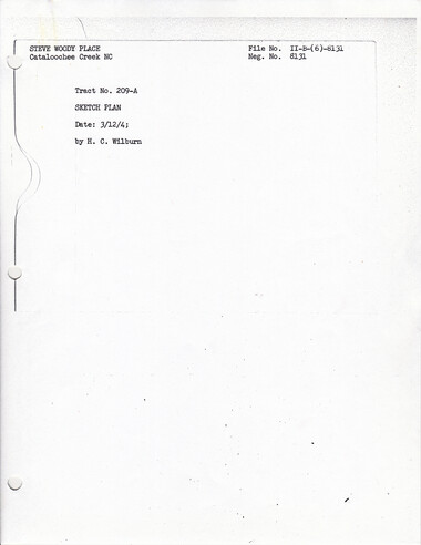
Cataloochee tract 209a: Johnathan Woody
GSMNP_02120_II-B-(6)-8131_b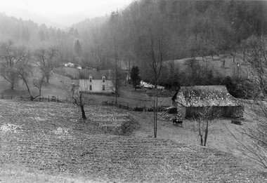
Cataloochee tract 209a: Johnathan Woody
GSMNP_02120_II-B-(6)-8133_a
Cataloochee tract 209a: Johnathan Woody
GSMNP_02120_II-B-(6)-8133_b
Cataloochee tract 209a: Johnathan Woody
GSMNP_02120_II-B-(6)-8134_a
Cataloochee tract 209a: Johnathan Woody
GSMNP_02120_II-B-(6)-8134_b
Cataloochee tract 209a: Johnathan Woody
GSMNP_02120_III-A-Gen-12220_a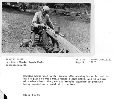
Cataloochee tract 209a: Johnathan Woody
GSMNP_02120_III-A-Gen-12220_b
Cataloochee tract 209a: Johnathan Woody
GSMNP_02120_III-A-Gen-12221_a
Cataloochee tract 209a: Johnathan Woody
GSMNP_02120_III-A-Gen-12221_b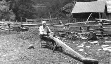
Cataloochee tract 209a: Johnathan Woody
GSMNP_02120_III-A-Gen-12222_a
Cataloochee tract 209a: Johnathan Woody
GSMNP_02120_III-A-Gen-12222_b
Cataloochee tract 209a: Johnathan Woody
GSMNP_02120_III-A-Gen-12223_a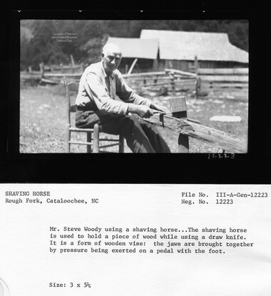
Cataloochee tract 209a: Johnathan Woody
GSMNP_02120_III-A-Gen-12223_b
Cataloochee tract 209a: Johnathan Woody
GSMNP_02120_III-A-Gen-12224_a
Cataloochee tract 209a: Johnathan Woody
GSMNP_02120_III-A-Gen-12224_b
Cataloochee tract 209a: Johnathan Woody
GSMNP_02120_III-A-Gen-12225_a
Cataloochee tract 209a: Johnathan Woody
GSMNP_02120_III-A-Gen-12225_b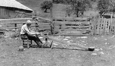
Cataloochee tract 209a: Johnathan Woody
GSMNP_02120_III-A-Gen-12226_a
Cataloochee tract 209a: Johnathan Woody
GSMNP_02120_III-A-Gen-12226_b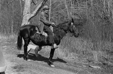
Cataloochee tract 209a: Johnathan Woody
GSMNP_02120_III-H-12786_a
Cataloochee tract 209a: Johnathan Woody
GSMNP_02120_III-H-12786_b
Cataloochee tract 209a: Johnathan Woody
GSMNP_02120_III-M-Stone-9164_a
Cataloochee tract 209a: Johnathan Woody
GSMNP_02120_III-M-Stone-9164_b
Cataloochee tract 209a: Johnathan Woody
GSMNP_02120_III-M-Stone-9170_a
Cataloochee tract 209a: Johnathan Woody
GSMNP_02120_III-M-Stone-9170_b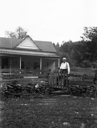
Cataloochee tract 209a: Johnathan Woody
GSMNP_02120_III-P-9603_a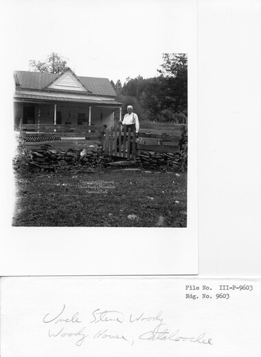
Cataloochee tract 209a: Johnathan Woody
GSMNP_02120_III-P-9603_b
Cataloochee tract 209a: Johnathan Woody
GSMNP_Cata-209a_Green_06
Cataloochee tract 209a: Johnathan Woody
GSMNP_Cata-209a_SteveWoody_01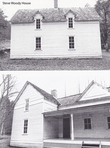
Cataloochee tract 209a: Johnathan Woody
GSMNP_Cata-209a_SteveWoody_02
Cataloochee tract 209a: Johnathan Woody
GSMNP_Cata-209a_SteveWoody_03
Cataloochee tract 209a: Johnathan Woody
GSMNP_Cata-209a_SteveWoody_04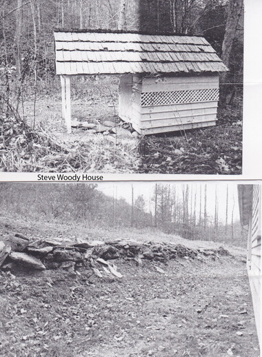
Cataloochee tract 209a: Johnathan Woody
GSMNP_Cata-209a_SteveWoody_05
Cataloochee tract 209a: Johnathan Woody
GSMNP_Cata-209a_SteveWoody_06
Cataloochee tract 209a: Johnathan Woody
GSMNP_Cata-209a_SteveWoody_08
Cataloochee tract 209a: Johnathan Woody
GSMNP_Cata-209a_SteveWoodyReunion_1936-06-02Item’s are ‘child’ level descriptions to ‘parent’ objects, (e.g. one page of a whole book).
-
-
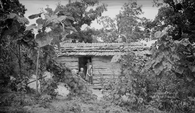
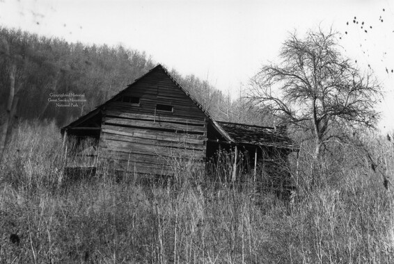
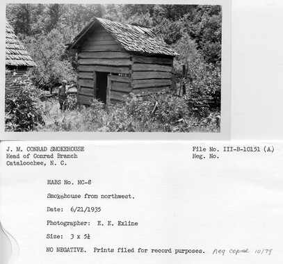
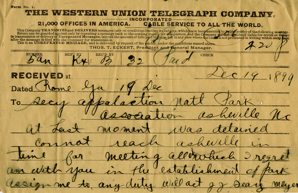
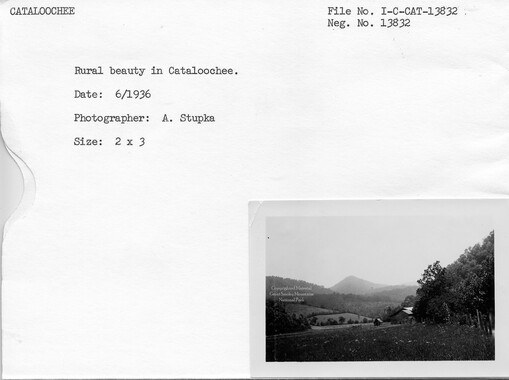
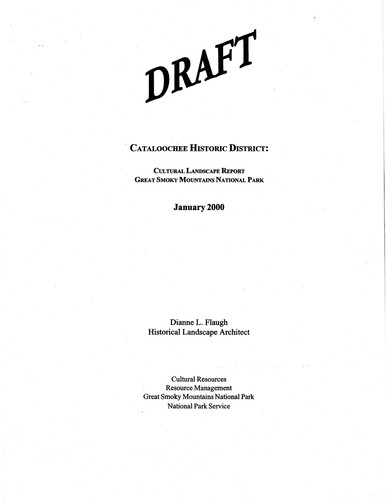
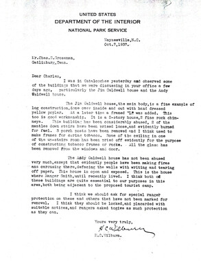
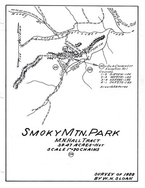
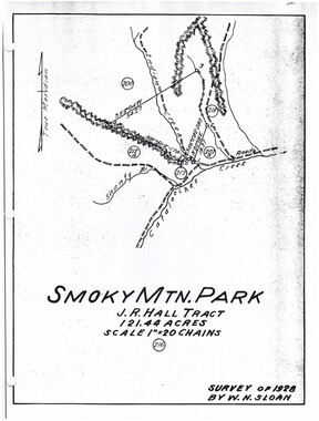
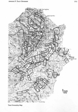
, CATALOOCHEE HISTORIC DISTRICT: CULTURAL LANDSCAPE REPORT GREAT SMOKY MOUNTAINS NATIONAL PARK January 2000 Dianne L. Flaugh Historical Landscape Architect Cultural Resources Resource Management Great Smoky Mountains National Park National Park Service 60 CULTURAL LANDSCAPE REPORT: CATALOOCHEE HisTORIC DISTRICT Big Cataloochee Steve Woody Tract (209a) Location Tract 209a is a 92.11-acre parcel located along Rough Fork Creek above its juncture with Messer Branch. The parcel straddles Rough Fork with most of the parcel is laying along the east side of the creek. History In 1876, the sale oftwo tracts ofland to Jonathan H. Woody from the Love holdings was recorded. He transferred both parcels to his son, Steve L. Woody, in 1884. In 1919, Steve L. Woody transferred the land to his daughter and son-in-law but by 1922, his son Jonathan Huff Woody, an Atlanta banker solely owned the land. The NCPC acquired tract 209a and the 59.38-acre tract 209 through condemnation proceedings from Jonathan HuffWoody in 1931 for $11,000. Steve Woody resided on tract 209a, which Jonathan HuffWoody leased, until his death in 1943. Jonathan and Malinda Plemmons Woody first arrived in Cataloochee approximately "---' 1842 but left the valley to raise a family. After the death ofMalinda in 1861 Woody returned to Cataloochee with the five youngest children. He married Mary Ann Caldwell, widow ofLevi Caldwell, in 1867/68 and raised their combined family in the Levi Caldwell cabin.' It is unclear how much of tract 209a was cleared during Jonathan Woody's ownership ofthe land. In 1879, Steve Woody married Mary Elizabeth Palmer and moved onto tract 209a.2 He indicated in the 1880 Agricultural Census that he tilled twelve acres, had three acres of permanent meadow, and eighty-five acres ofwoodland. Steve Woody raised crops typical to Cataloochee growing com, hay, sorghum, beans, and potatoes. No orchard crops were listed. Steve Woody kept bees, raised chickens and owned two milk cows, seventeen cattle, eleven sheep, and ten hogs. During condemnation proceedings it was testified that Steve Woody rotated crops of com, hay, and oats. These crops were raised primarily to feed livestock rather than to sell at market. Livestock included fifty to seventy-five head of cattle, as well as sheep and hogs. Manure was spread as fertilizer on the crop and garden land. His orchards could be found on both sides of Rough Fork Creek. Trees numbered approximately one hundred and included four to five different varieties of"winter fruit."3 Woodland on the property was considered to be virgin timber by the Woody family. They testified that they only used downed timber or timber from land they cleared for frrewood.4 However, other sources indicate that commercial logging did occur on this parcel. Lumber used in constructing a house addition (ca 1900) was ''taken in toll by Steve Woody, 'from a commercial sawyer who had set up about a half-mile above the '..__., house on some of his timberland. "'5 The extent and location of this logging activity is unknown. I I I I I ' I , I I I I I I I I I I I· I I , I CHAPTER 4: INDIVIDUAL TRACTS ' 61 Jonathan Huff Woody was an Atlanta banker and used the property to entertain guests. He continued to do so on an occasional basis for personal and professional purposes after the death of his father in 1943. Steve Woody participated in the recreation/tourism trade in Cataloochee by provided in accommodations and stocking the stream with fish. Accommodations for guests were available in the house and barn at fifty cents a night in the house or twenty cents per night in the barn.6 The Woody family also had an area for tent campers at the juncture of Rough Fork and Messer Branch on tract 210.7 Survey teams from the North Carolina Park Commission and Suncrest Lumber Company used the camp.8 In addition to stocking the stream, Woody also limited fishing as needed to rebuild the fish population. Vegetation NCPC records indicate this tract included 4.47 acres of cultivated land, 14.45 acres of grassland, 8.9 acres of grownup land [previously cleared], and 26.69 acres of woodland. Although the NCPC records do not include orchard acreage, there were orchards located on both sides ofRough Fork Creek. Photographs (ca. 1940) show orchards both to the rear ofthe house and on the hillside across Rough Fork opposite the house (figure 16). Those to the rear o(the house appeared to be mature fruit trees. The photographs also show open fields and pastures surrounding the house site. Most of the woodland laid south of the homesite on the east side of Rough Fork. Figure 16. Looking east across Rough Fork to the Steve Woody homestead, 1940. GRSM Archives. Circulation Access to this parcel was by way of the old setter road through Cataloochee Valley. With no other families living above the Woody property on Rough Fork, the road ended on this tract. The route ran along side Rough Fork and involved three stream fords to reach the house site. Footbridges were also in place at the ford locations. During the years 1934/ 62 CULTURAL LANDSCAPE REPORT: CATALOOCHEE HISTORIC DISTRICT 193 8 CCC crews made road improvements (ditched, graded, and surfaced) from the Big Fork Ridge Trailhead to the Woody house (figure 17).9 Figure 17. Road, ford and foot bridge along Rough Fork below the Steve Woody homestead, 1936. GRSM Archives. Although the road ended on the Woody property, trails continued up Rough Fork and Little Ridge to Polls Gap. The Suncrest Lumber Company railroad ran through Polls Gap into the Cataloochee watershed to reach timber on their holdings. This railroad had already come within two miles of the Woody house. 10 Structures, Furnishings, and Objects Records indicate that the property included a house, log barn with frame additions, frame can house, springhouse, woodshed, tool house, smokehouse, garage, pigpen, and chicken house. The house is a two-story frame covered building at the core of which is a hewn poplar log cabin. While the exact construction date is unknown, notes taken as part of building survey work indicate that Steve Woody built it prior to 1890.11 Steve Woody, when questioned by Wilburn, indicated a construction of 1880/82. 12 The large two-story framed addition was construc~ted in the early to mid 1900's. It is likely that the front porch was also built at that time. The fmal addition to the house was the kitchen and back porch about 1910.13 The log barn had been constructed "a few years after the house." It included two stalls, both measuririg 12' square; and a crib measuring 6' by 12'. There was a 14' drive between the stalls and a 1 0' drive between the crib and stall. A loft overhung the stalls by 10' on the north, east, and south sides. The overhang area was boarded in with vertical boards to provide protection for cattle. 14 Fences enclosed areas around the house and barn, and fences were also found on the slopes separating cultivated areas from pasture and on the opposite side of Rough Fork Creek. The types of fences and the materials used are varied. Photographs reveal that much of the fencing around the house and barn was rail post and rider, but also included plank, barbed wire, and stone fencing. •• •• II II I II I I I I I I I I ' ' I I I CHAPTER 4: l NDfVIDUAL TRACTS 63 The garden, found close to the springhouse, was also fenced. The garden fencing was wire, topped with two strands ofbarbed wire to keep out chickens. 15 Existing Conditions The Woody house area is designated as an historic preservation area in the current GMP. The house and springhouse are open to visitors as a NPS historic interpretive exhibit. With the exception ofa small area of open land north and south ofthe house this entire tract has reforested. Fonner open field areas remain evident, populated by stands of tulip poplar and maple. An occasional young volunteer apple can be found but no other remnant of the one hundred tree apple orchard remains. In the yard area surrounding the house a mature cedar tree and pear tree survive (figure 18). Figure 18. Mature Cedar Tree, 1998. Access to the site continues to follow the route improved by the CCC and includes three stream fords. This route is known as Rough Fork Trail and is open to foot and horse traffic ending at Polls Gap. It is also a park administrative road to the Woody house. NPS maintained footbridges are found at each stream crossing. 64 C ULTIJRAL LANDSCAPE REPORT: CATALOOCHEE HISTORIC DISTRICT The frame house and springhouse are the only structures remaining on site. All other buildings have been removed (date unknown). Stones form a retaining wall wrapping around the rear of the house. Stones also etch the lines of the former yard fence, and walkways. Short sections of both wood and wood post and wire remnant fencing remain and are found throughout the tract. One short section of wood fence with a cattle gate (probable NPS addition, date unknown) blocks horse traffic to the springhouse from the south. A hitching post (NPS addition, 1992) is found along the trail in front of the house. Analysis and Evaluation This site is associated with the Woody family. The Woody family became an important part of the Cataloochee community with close ties to other valley families. The site reflects agricultural use of the land and settlement patterns. It is the southern most point of Big Cataloochee Valley claimed and settled. Although much of the land used for agriculture has reforested it remains identifiable through the dominant type of forest cover. The historic setting of the Woody house along side the trail and creek with former agricultural fields spreading out from the farmstead remains evident. The house remains unmodified by the NPS. It reflects the building construction traditions of expanding and improving existing structures and the use of native materials. Some site features such as orchards, walkways, and house and barnyard fencing are severely deteriorated or missing. Access to the site by way of Rough Fork Trail contributes to site integrity. Circa 193 6 photographs of this road show that the current conditions of surface material, width, and surroundings are consistent with the historic conditions. The style of footbridge has changed but continue to be constructed of native materials. The historic condition ofthe site can be enhanced through the addition of fencing in the house and barn areas, improved mowing and bush hogging of the open areas north and south of the house. Special attention to preserving the extant pear and cedar tree is also appropriate. NOTES 1 Ed Trout, "Draft Historic Structure Report - Woody House," Great Smoky Mountains National Park, [1991), I. 2 Ibid., 2. 3 Condemnation Proceedings, North Carolina vs. J. S. Woody et al., 1931, GRSM Archives, NC ll-2, 247, 257,260. 4 Ibid., 249. 5 Trout, 7. 6 Trout, 5. 7 The heirs of Mary Caldwell Woody, first wife of Steve Woody, owned tract 21 0. 8 Condemnation Proceedings, 250, 261,271,288. 9 F. W. Cron, "Road System Inventory and Inspection Reports, Secondary Roads," [1950]. 10 Condemnation Proceedings, 249. 11 Historic American Building Survey Note Cards, Steve Woody Place- Frame and Log House, [ 1935/ 37], photocopy. •• I I I I I I I I I I 1\_/ I I I II I I I •• CHAPTER 4: INDIVIDUAL TRACTS 65 12 Hiram C. Wilburn, Interview notes, H. C. Wilburn Papers, Special Collections, Hunter Library, Western North Carolina University, Cullowhee, NC, 51. · 13 Trout, 4. 14 Historic American Building Survey Note Cards, Steve Woody Place- Log Bam, [ 1935/3 7], photocopy. IS Condemnation Proceedings, 260. ( ( ( Legend: r- Uno ""-'" ~ an.-. - ----- -- ._ r- "6 -Uno SfMI T#MI & SIMa ~~$~ CUL TURAI.LANOSCAPE REPORT CATA!.OOCtiEE HISTORIC DISTRICT HAYWOOD COUNTY. NORTliCAROUNA BIG CATALOOCHEE VALLEY STEVE WOODY TRACT 2098 PROPOSED TREATMENT - HATIOIW. PMKII&MCI! GREAT SMOKYUOUNT-NAliOIW. PARK RE$0\JRCE -Nf-<:UI.lUIW. l\fSOUAt£$ DIIAWIIIV: --L Fllugh DAlE: "'-3. 1- DRAYNIGNO. \ I \....__.) ·Q · -~ 0 0 {)~ ·a ·C. 0 · 0 .- 0 . . -.1 eJ" ~ . ~ - 0 ....... . . A: : a 0 . <:J o ··. Wilburn Sketch Plan- Steve Woody Tract 209a (NTS) H-2
Object’s are ‘parent’ level descriptions to ‘children’ items, (e.g. a book with pages).
-
This 151.5 acres in Cataloochee tracts 209 and 209a were owned by Jonathan Woody. Along with these documents are several photographs relating to the tracts. While, in general, the Great Smoky Mountains region was sparsely populated, the Cataloochee Valley remained an exception. By 1900, the population of Cataloochee had grown to 1,000 residents living in hundreds of log and frame homes. A few historic buildings have been preserved on site, including two churches, a school, several homes, and outbuildings. The North Carolina Park Commission was tasked with purchasing land for the Great Smoky Mountains National Park and people living in Cataloochee were among those displaced. Cataloochee families continue to return for annual reunions. In 2001, the National Park Service re-introduced elk into the valley.
-


Part of Collection
Great Smoky Mountains - A Park for America