- Canton Champion Fibre Company (2308)
- Cherokee Traditions (293)
- Civil War in Southern Appalachia (165)
- Craft Revival (1942)
- Great Smoky Mountains - A Park for America (2683)
- Highlights from Western Carolina University (430)
- Horace Kephart (941)
- Journeys Through Jackson (154)
- LGBTQIA+ Archive of Jackson County (15)
- Oral Histories of Western North Carolina (314)
- Picturing Appalachia (6679)
- Stories of Mountain Folk (413)
- Travel Western North Carolina (160)
- Western Carolina University Fine Art Museum Vitreograph Collection (129)
- Western Carolina University Herbarium (92)
- Western Carolina University: Making Memories (708)
- Western Carolina University Publications (2283)
- Western Carolina University Restricted Electronic Theses and Dissertations (146)
- Western North Carolina Regional Maps (71)
- World War II in Southern Appalachia (131)
- Allanstand Cottage Industries (62)
- Appalachian National Park Association (53)
- Bennett, Kelly, 1890-1974 (1295)
- Berry, Walter (76)
- Brasstown Carvers (40)
- Carver, George Washington, 1864?-1943 (26)
- Cathey, Joseph, 1803-1874 (1)
- Champion Fibre Company (233)
- Champion Paper and Fibre Company (297)
- Cherokee Indian Fair Association (16)
- Cherokee Language Program (22)
- Crowe, Amanda (40)
- Edmonston, Thomas Benton, 1842-1907 (7)
- Ensley, A. L. (Abraham Lincoln), 1865-1948 (275)
- Fromer, Irving Rhodes, 1913-1994 (70)
- George Butz (BFS 1907) (46)
- Goodrich, Frances Louisa (120)
- Grant, George Alexander, 1891-1964 (96)
- Heard, Marian Gladys (60)
- Kephart, Calvin, 1883-1969 (15)
- Kephart, Horace, 1862-1931 (313)
- Kephart, Laura, 1862-1954 (39)
- Laney, Gideon Thomas, 1889-1976 (439)
- Masa, George, 1881-1933 (61)
- McElhinney, William Julian, 1896-1953 (44)
- Niggli, Josephina, 1910-1983 (10)
- North Carolina Park Commission (105)
- Osborne, Kezia Stradley (9)
- Owens, Samuel Robert, 1918-1995 (11)
- Penland Weavers and Potters (36)
- Roberts, Vivienne (15)
- Roth, Albert, 1890-1974 (142)
- Schenck, Carl Alwin, 1868-1955 (1)
- Sherrill's Photography Studio (2565)
- Southern Highland Handicraft Guild (127)
- Southern Highlanders, Inc. (71)
- Stalcup, Jesse Bryson (46)
- Stearns, I. K. (213)
- Thompson, James Edward, 1880-1976 (226)
- United States. Indian Arts and Crafts Board (130)
- USFS (683)
- Vance, Zebulon Baird, 1830-1894 (1)
- Weaver, Zebulon, 1872-1948 (58)
- Western Carolina College (230)
- Western Carolina Teachers College (282)
- Western Carolina University (1794)
- Western Carolina University. Mountain Heritage Center (18)
- Whitman, Walt, 1819-1892 (10)
- Wilburn, Hiram Coleman, 1880-1967 (73)
- Williams, Isadora (3)
- Cain, Doreyl Ammons (0)
- Crittenden, Lorraine (0)
- Rhodes, Judy (0)
- Smith, Edward Clark (0)
- Appalachian Region, Southern (2393)
- Asheville (N.C.) (1886)
- Avery County (N.C.) (26)
- Blount County (Tenn.) (147)
- Buncombe County (N.C.) (1664)
- Cherokee County (N.C.) (283)
- Clay County (N.C.) (555)
- Graham County (N.C.) (233)
- Great Smoky Mountains National Park (N.C. and Tenn.) (478)
- Haywood County (N.C.) (3522)
- Henderson County (N.C.) (70)
- Jackson County (N.C.) (4692)
- Knox County (Tenn.) (21)
- Knoxville (Tenn.) (9)
- Lake Santeetlah (N.C.) (10)
- Macon County (N.C.) (420)
- Madison County (N.C.) (211)
- McDowell County (N.C.) (39)
- Mitchell County (N.C.) (132)
- Polk County (N.C.) (35)
- Qualla Boundary (981)
- Rutherford County (N.C.) (76)
- Swain County (N.C.) (2017)
- Transylvania County (N.C.) (247)
- Watauga County (N.C.) (12)
- Waynesville (N.C.) (68)
- Yancey County (N.C.) (72)
- Aerial Photographs (3)
- Aerial Views (60)
- Albums (books) (4)
- Articles (1)
- Artifacts (object Genre) (228)
- Biography (general Genre) (2)
- Cards (information Artifacts) (38)
- Clippings (information Artifacts) (191)
- Crafts (art Genres) (622)
- Depictions (visual Works) (21)
- Design Drawings (1)
- Drawings (visual Works) (184)
- Envelopes (73)
- Facsimiles (reproductions) (1)
- Fiction (general Genre) (4)
- Financial Records (12)
- Fliers (printed Matter) (67)
- Glass Plate Negatives (381)
- Guidebooks (2)
- Internegatives (10)
- Interviews (811)
- Land Surveys (102)
- Letters (correspondence) (1013)
- Manuscripts (documents) (619)
- Maps (documents) (159)
- Memorandums (25)
- Minutes (administrative Records) (59)
- Negatives (photographs) (5651)
- Newsletters (1285)
- Newspapers (2)
- Occupation Currency (1)
- Paintings (visual Works) (1)
- Pen And Ink Drawings (1)
- Periodicals (193)
- Personal Narratives (7)
- Photographs (12982)
- Plans (maps) (1)
- Poetry (5)
- Portraits (1655)
- Postcards (329)
- Programs (documents) (151)
- Publications (documents) (2237)
- Questionnaires (65)
- Scrapbooks (282)
- Sheet Music (1)
- Slides (photographs) (402)
- Sound Recordings (796)
- Specimens (92)
- Speeches (documents) (15)
- Tintypes (photographs) (8)
- Transcripts (322)
- Video Recordings (physical Artifacts) (23)
- Vitreographs (129)
- Text Messages (0)
- A.L. Ensley Collection (275)
- Appalachian Industrial School Records (7)
- Appalachian National Park Association Records (336)
- Axley-Meroney Collection (2)
- Bayard Wootten Photograph Collection (20)
- Bethel Rural Community Organization Collection (7)
- Blumer Collection (5)
- C.W. Slagle Collection (20)
- Canton Area Historical Museum (2110)
- Carlos C. Campbell Collection (198)
- Cataloochee History Project (65)
- Cherokee Studies Collection (4)
- Daisy Dame Photograph Album (5)
- Daniel Boone VI Collection (1)
- Doris Ulmann Photograph Collection (112)
- Elizabeth H. Lasley Collection (1)
- Elizabeth Woolworth Szold Fleharty Collection (4)
- Frank Fry Collection (95)
- George Masa Collection (173)
- Gideon Laney Collection (452)
- Hazel Scarborough Collection (2)
- Hiram C. Wilburn Papers (28)
- Historic Photographs Collection (236)
- Horace Kephart Collection (861)
- Humbard Collection (33)
- Hunter and Weaver Families Collection (1)
- I. D. Blumenthal Collection (4)
- Isadora Williams Collection (4)
- Jesse Bryson Stalcup Collection (47)
- Jim Thompson Collection (224)
- John B. Battle Collection (7)
- John C. Campbell Folk School Records (80)
- John Parris Collection (6)
- Judaculla Rock project (2)
- Kelly Bennett Collection (1314)
- Love Family Papers (11)
- Major Wiley Parris Civil War Letters (3)
- Map Collection (12)
- McFee-Misemer Civil War Letters (34)
- Mountain Heritage Center Collection (4)
- Norburn - Robertson - Thomson Families Collection (44)
- Pauline Hood Collection (7)
- Pre-Guild Collection (2)
- Qualla Arts and Crafts Mutual Collection (12)
- R.A. Romanes Collection (681)
- Rosser H. Taylor Collection (1)
- Samuel Robert Owens Collection (94)
- Sara Madison Collection (144)
- Sherrill Studio Photo Collection (2558)
- Smoky Mountains Hiking Club Collection (616)
- Stories of Mountain Folk - Radio Programs (374)
- The Reporter, Western Carolina University (510)
- Venoy and Elizabeth Reed Collection (16)
- WCU Gender and Sexuality Oral History Project (32)
- WCU Mountain Heritage Center Oral Histories (25)
- WCU Oral History Collection - Mountain People, Mountain Lives (71)
- WCU Students Newspapers Collection (1744)
- Western North Carolina Tomorrow Black Oral History Project (69)
- William Williams Stringfield Collection (2)
- Zebulon Weaver Collection (109)
- African Americans (388)
- Appalachian Trail (32)
- Artisans (521)
- Cherokee art (84)
- Cherokee artists -- North Carolina (10)
- Cherokee language (21)
- Cherokee pottery (101)
- Cherokee women (208)
- Church buildings (166)
- Civilian Conservation Corps (U.S.) (110)
- College student newspapers and periodicals (1830)
- Dams (94)
- Dance (1023)
- Education (222)
- Floods (60)
- Folk music (1015)
- Forced removal, 1813-1903 (2)
- Forest conservation (220)
- Forests and forestry (917)
- Gender nonconformity (4)
- Great Smoky Mountains National Park (N.C. and Tenn.) (154)
- Hunting (38)
- Landscape photography (10)
- Logging (103)
- Maps (84)
- Mines and mineral resources (8)
- North Carolina -- Maps (18)
- Paper industry (38)
- Postcards (255)
- Pottery (135)
- Railroad trains (69)
- Rural electrification -- North Carolina, Western (3)
- School integration -- Southern States (2)
- Segregation -- North Carolina, Western (5)
- Slavery (5)
- Sports (452)
- Storytelling (245)
- Waterfalls -- Great Smoky Mountains (N.C. and Tenn.) (66)
- Weaving -- Appalachian Region, Southern (280)
- Wood-carving -- Appalachian Region, Southern (328)
- World War, 1939-1945 (173)
Cataloochee tract 224: Jarvis L. Palmer

Cataloochee tract 224: Jarvis L. Palmer
GSMNP_Cata-224-224a
Cataloochee tract 224: Jarvis L. Palmer
GSMNP_80235
Cataloochee tract 224: Jarvis L. Palmer
GSMNP_80235_01-05
Cataloochee tract 224: Jarvis L. Palmer
GSMNP_Cata-224_370
Cataloochee tract 224: Jarvis L. Palmer
GSMNP_Cata-224_369
Cataloochee tract 224: Jarvis L. Palmer
GSMNP_Cata-224_371
Cataloochee tract 224: Jarvis L. Palmer
GSMNP_Cata-224_372_03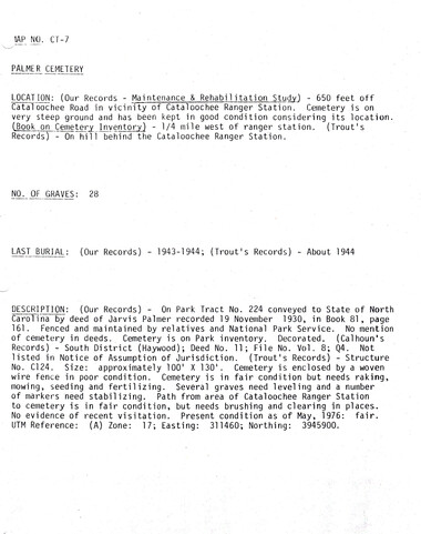
Cataloochee tract 224: Jarvis L. Palmer
GSMNP_Cata-224_CT-7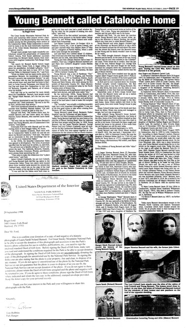
Cataloochee tract 224: Jarvis L. Palmer
GSMNP_Cata-224_Ford_News_02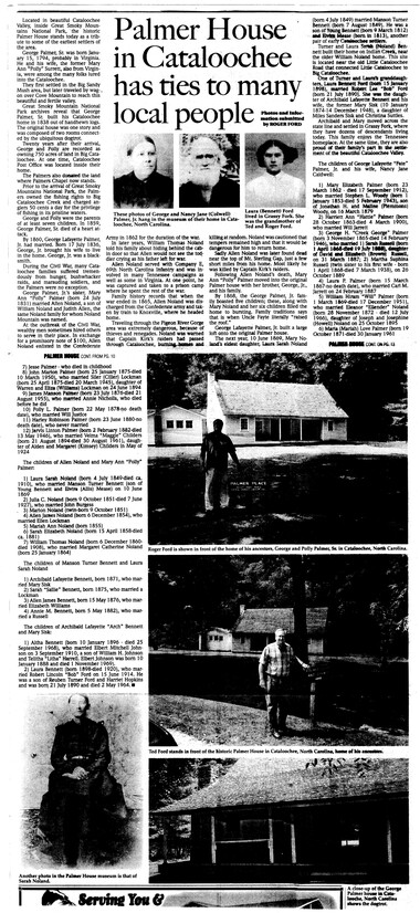
Cataloochee tract 224: Jarvis L. Palmer
GSMNP_Cata-224_Ford_News_04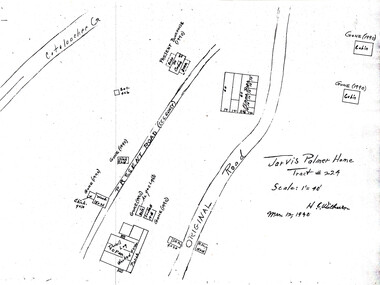
Cataloochee tract 224: Jarvis L. Palmer
GSMNP_Cata-224_373
Cataloochee tract 224: Jarvis L. Palmer
GSMNP_02120_III-B-10480_a
Cataloochee tract 224: Jarvis L. Palmer
GSMNP_02120_III-B-10480_b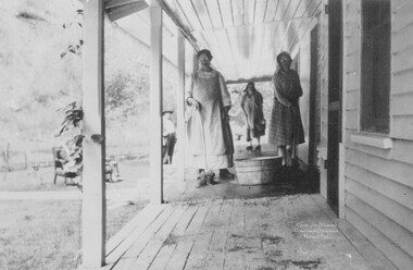
Cataloochee tract 224: Jarvis L. Palmer
GSMNP_02120_III-P-17851_a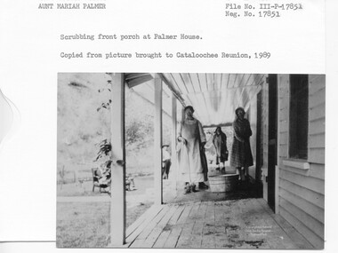
Cataloochee tract 224: Jarvis L. Palmer
GSMNP_02120_III-P-17851_b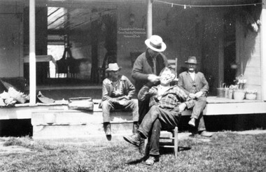
Cataloochee tract 224: Jarvis L. Palmer
GSMNP_02120_III-P-17852_a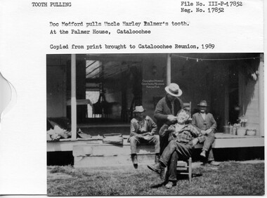
Cataloochee tract 224: Jarvis L. Palmer
GSMNP_02120_III-P-17852_b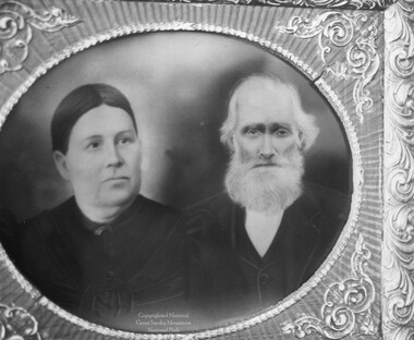
Cataloochee tract 224: Jarvis L. Palmer
GSMNP_02120_III-P-18000_a
Cataloochee tract 224: Jarvis L. Palmer
GSMNP_02120_III-P-18000_bItem’s are ‘child’ level descriptions to ‘parent’ objects, (e.g. one page of a whole book).
-
-
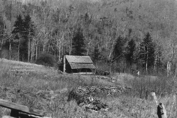
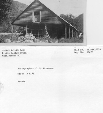
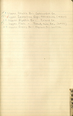
"'--- - ------------------------.,---- ------------- ,_ CATALOOCHEE HISTORIC DISTRICT: CULTURAL LANDSCAJ>E REPORT GREAT SMOKY MOUNTAINS NATIONAL PARK January 2000 Dianne L. Flaugh Historical Landscape Architect Cultural Resources Resource Management Great Smoky Mountains National Park National Park Service 86 CULTURAL LANDSCAPE REPORT: CATALOOCHEE HisTORIC DISTRICT Jarvis Palmer Tract (224) Location Tract 224 is a 258.57-acre parcel located along Cataloochee Creek beginning just south of Winding Stair Branch. The parcel straddles Cataloochee Creek with most of the parcel running along the north side of the creek. History A grant of two hundred ten acres of land from the Love holdings to George Palmer was recorded in 1858. After his death in 1859, George Lafayette Palmer (Fayt) inherited the land. The size ofFayt Palmer's holdings increased when in 1884 he acquired one hundred fifteen acres of ari adjoining property. Together, these two properties form tract 224. Upon the death ofFayt Palmer in 1910, Jarvis Palmer inherited the property. The NCPC acquired parcel 224 from Jarvis Palmer in 1931. Jarvis Palmer continued to lease and reside on the property until September 7, 1938. George Palmer and his family settled in Cataloochee in 1839. He and his wife Polly Starrett had a family of seven and the 1850 Census includes four ofthese children and one non-family member. 1 Like most settlers ofwestem North Carolina, they were subsistence fanners. In the 1850 Agricultural Census George Palmer indicated ownership of two hundred acres of land. On twenty acres of improved land he grew com as well as tobacco and potato crops. As was common for residents of Cataloochee, livestock was Palmer's principal source of income. He owned two horses, five milk cows, eight cattle, ten hogs, and three sheep in 1850. Over the years, the household ofFayt Palmer included his wife Nancy Jane Caldwell, widowed mother, sister, eleven children, and the occasional non-family member.2 His land holdings in Cataloochee had increased to six hundred ten acres in 1880 (recorded in the 1880 Agricultural Census). Ofthis land, sixty acres was cultivatable and twelve was permanent pasture. It is unknown how much of this improved land was part of tract 224. Com remained the principal crop with thirty acres planted in com. Also in 1879, Fayt Palmer cut and stored six tons ofhay for winter livestock feed. This is a significant change from 1850 when George Palmer did not record the harvest of any hay. Other crops raised included wheat, eighteen acres; oats, eight acres; buckwheat, three acres; and sorghum, one-half acre. Fayt Palmer had a two acre orchard that included seventyfive bearing apple trees. The location of this orchard is unknown. Livestock remained a significant part ofFayt Palmer's agricultural operation. Although the types oflivestock remained the same, the number of animals increased. By 1880, Palmer owned three horses, three mules, nine milk cows, twenty-seven cattle, sixty hogs, and twenty-seven sheep. Palmer also tended bees and his hives produced five hundred fifty pounds ofhoney in 1879. Jarvis Palmer continued to use tract 224 for agriculture even after its acquisition for the Park. Sometime after 1910, he built a large bam to house animals and store feed. Ranger John Needham noted that in 1933, Jarvis Palmer grew a corn crop that exceeded fifteen feet in height.3 ~ ~ •• • ' I I I I I I I I - .. I r '----..../ I I I I I I I I''-._/. I I I I I I , ''--._../ CHAPTER 4: INDIVIDUAL TRACTS 87 While no infonnation specific to commercial logging on this parcel is available, one area of this tract was selectively harvested. Jarvis Palmer harvested the yellow pine used to construct his barn from the ridge above the present day campground.4 The Jarvis Palmer household included his first wife, Rebecca Childers; two children; and his unmarried brother and sister, Harley and Maria. Jarvis married Velma Childers, sister of Rebecca, in 1924. Harley and Maria both owned land in Cataloochee, but continued to live and work on tract 224 with Jarvis.5 With the help and resources of this extended family, Jarvis Palmer was able to expand the family enterprises beyond agricul- , ture to include tourism and fishing. The combined landholdings of Jarvis, Maria, and Harley Palmer extended along almost three miles of Cataloochee Creek giving them control over a long stretch of prime trout fishing stream.6 Their fishing and tourism activities began in the 191 Os, continuing until 193 8, when Jarvis ended his lease with the park. At that time, Jarvis was the last operator providing meals and accommodations in the Park on the North Carolina side.7 Each family member had a role in the family business. Harley patrolled the stream to collect the fifty-cent fishing fee or send away non-paying fishennan. Maria and Velma kept house and cooked, keeping food available at all times for their guests on the dining room table. Much of the food served came from the garden tended by the two women. This large fenced garden area lay between the house and barn. Separate fees of fifty cents paid for accommodations and meals.8 During the early to mid-1920s, two additions were made to the Palmer house. These additions, necessitated by the tourist business, were built on the west end of the structure. The first acted as a dining hall, and the second addition as a kitchen.9 To house paying guests Jarvis Palmer built three tourist cabins, each with an outside pit privy. Constructed ofroughsawn lumber, each ofthe cabins was painted brown and covered with metal roofs. The first two were built about 191 ~ on the hill above the barn. The last cabin was built about 1924, along Cataloochee Creek near the barn. At some point it may also have housed the valley schoolteacher. At full capacity these guest cabins could accommodate a total of forty-two people. 10 The Palmer house also served as one of three post offices in Cataloochee. Called the Cataloochee Post Office, Maria Palmer operated it out of one of the two small, enclosed rooms off the rear porch (southeast corner). The Cataloochee Post Office operated from this location until June 15, 1932, when it closed. The date of its establishment at the Palmer house is unknown. The Cataloochee Post Office previously operated out of at least two other sites; the Young Bennett place and Frank Palmer place. 11 Following the departure of Jarvis Palmer, the house was designated to serve as a Warden Station. Ranger John B. Carroll moved into the Palmer House on September 12, 1938. The house served this purpose until 1971 after which it became a bunkhouse for seasonal rangers and maintenance personnel. Seasonal use ofthe house ended in 1978 when seasonal housing was moved to the remaining tourist cabin. The Palmer House is currently open to the public. The dining hall and kitchen additions have functioned as a small interpretive museum since 1981. 12 • I '-....._/ 88 C ULllJRAL L ANDSCAPE REPORT: C ATALOOCHEE HlsTORIC DISTRICT Vegetation NCPC records indicate that parcel 224 consisted of nine acres of cultivated fields, fifteen acres ofbottom pasture, twenty-one acres ofbottomland, and two hundred thirteen acres of woodland. Most of the woodland was oak and chestnut forest and lay on the slopes west of the homestead. Although no orchard was included in the NCPC records photograph do show fruit trees. Mark Hannah recalled that the homestead included a Milan apple, two grafted apple trees, and a wild peach tree near the can house. 13 Circulation The old settler road that forded Cataloochee Creek north of this tract historically provided access to the tract. Its path lay along the bank of Cataloochee Creek but near the Palmer farmstead it deviated from this course to run along the base of the slope. The road separated the blacksmith shop and two hillside tourist cabins from the remainder of the farm complex found on levelland south of the road. Beginning in 1941, the CCC constructed the current gravel road through the parcel. The route of the road changed to run south of the house and barn, and between the barn and creekside tourist cabin. This effectively changed the rear of the house into the front. A trace road, providing access to tracts 221 and 221 a, ran through tract 224 near its southern end. Thil) road branched off the settler road to run along the northwest side of Upper Double Branch. Structures, Furnishings, and Objects NCPC records indicated that the tract included a nine-room framed house, three tourist cabins, applehouse (can house), smokehouse, springhouse, and six-stall barn. The site is also known to have included a log blacksmith shop, two chicken houses, and privies (associated with the tourist cabins). Family tradition holds that the first Palmer house was built a few hundred yards from the current house site. Its exact location is unknown. The current house is situated on level ground and close to the base of the slope. It had it origins as two one-story rooms constructed of hewn logs, separated by a breezeway and covered by a common roof. Additions over time converted this simple structure into a one and one-half story building with eleven rooms and front and rear porches. The earliest known photograph looks down from the hillside onto a homestead that includes several log outbuildings (figure 29), The house is covered with frame siding and roofed with wood shingles. A frame-constructed springhouse stands close by the dirt road. A tall, wooden picket fence surrounds the house yard, its base sealed by large stones and wide plank boards. A wooden picket gate, its pickets cut to trace an arch, provides access to the yard. A walk leads from the gate to the front porch, which was reached by two sets of four to five wooden steps. The base of the porch is open to show stone pier supports. Inside the yard, a fruit tree in full flower stands close by the gate. The yard is otherwise uncluttered. Beyond the house wood fences enclosed fields. ,, • i Figure 29. Palmer homestead, date unknown. GRSM Archives. P,$~r~~'•'j~ ;e: • J ~- ~ A series of photographs date from the period that Jarvis Palmer offered accommodations and meals. From these photographs the differing uses of the front and rear porches is apparent. The front porch put forth a public face, perhaps for the benefit of paying guests, while the rear porch was a working space. A concrete walk lead up to the stone and concrete steps of the front porch while the rear porch had wooden steps. The front porch has guttering while the back porch does not. A vine is beginning to scramble up a post on the front porch that is kept neat and tidy. 14 The rear porch supports a clothesline and is cluttered with household items such as baskets and firewood. The house yard remains enclosed by a picket fence that is lower in height than the earlier picket fence. The yard remains uncluttered with just a few shrubs and small trees. The trunk of one tree is painted white. Livestock, as seen in one photograph, kept the grass trimmed. The new frame barn has been constructed and appears to have been painted white. Frame can house and the smokehouse buildings had replaced a log outbuilding that previously stood near the springhouse. A hillside tourist cabin is visible on the thinly wooded slope west of the house. The dining hall addition to the house had been constructed and roofed with asphalt shingles, while the remainder of the house roof is covered with sheet tin. Another series of photographs was taken in the late 1930s and prior to Park remodeling in 1940/41. In these photographs the CCC road either has not been built or is being constructed. The yard is remains enclosed by picket fencing. Beehives stand just outside the yard fence at the rear ofthe house. Corn stalks stand in the field north of the house and the garden area is tilled. Construction drawings (ca. 1940) for the Cataloochee Creek Road identifies a fenced garden area stretching between the house and barn. The Park began to use the Jarvis Palmer homestead as quarters in 1938. Renovations soon began and were completed in 1941. During remodeling the wood steps of the porch on the southeast side of the house were replaced with stone and concrete. The foundation of the house was neatly sealed with stone. The house was re-roofed with wood shingles I I t j 90 CULTURAL LANDSCAPE REPORT: CATALOOCHEE HlsTORIC DISTRICT and the house exterior painted white with a dark blue-green trim. At some point, an addition to the bam, seen in earlier photographs was removed. The picket fence around the houseyard was removed although it still extended along one side of a garden. The remainder of the garden fence was wood post and woven wire. Boxwood shrubs were planted at foundation of the house and young trees in the lawn. Changes continued to be made during the time the house was used as quarters. Roofmg changed from wood shingle to asphalt, the kitchen chimney was moved, and the dogtrot was enclosed. Outbuildings decayed and were removed. The dates of removal for the two chicken houses, woodshed, can house, smokehouse, and two tourist cabins are unknown. In 1977, a trailer was placed along the trace road in the open space between the house and bam. The date of its removal is unknown but it is noted in a sketch plan of the property (ca. 1989). Cemetery The Palmer Family Cemetery is located on the hillside northwest of the Palmer house. The earliest known burials here were that of George Palmer ( 1794-1859) and his daughter Ruth Vess ( 1824-1859) indicating that the cemetery was established circa 1859. No detailed documentation ofthe historic appearance of the cemetery has been located. Photographs taken during the occupancy of Jarvis Palmer show the slope to be thinly wooded as if used for pasture land. Fencing was likely used to exclude animals from the cemetery. Existing Conditions The Jarvis Palmer complex is included in the area designated for historic preservation by the GMP. The Palmer house, springhouse, and blacksmith shop are open to the public as a NPS interpretive exhibit. An interpretive film and a display of photographs and artifacts are found in the kitchen and dining hall additions to the Palmer House. The bam is used for storage, and the remaining tourist cabin is used as an employee bunkhouse. A small gravel area along the road in front of the house accommodates visitor parking at the Palmer Complex. Trash cans and picnic tables are also in place at the homestead. One of the tract's former agricultural fields at the south end of the parcel is now the location of the Cataloochee campground. The campground area is dominated by white pine and tulip poplar. Other former field areas north of the Palmer complex are kept open through routine mowing. Except for these areas around the Palmer complex the entire tract is now forested. Some former agriculturally used areas were planted to white pine plantations, while others are dominated by tulip poplar and white pine. 15 Access to the Palmer complex is by way of the CCC constructed Cataloochee Creek Road. The trace of the old settler road through this tract remains evident, especially in the area of the homestead (figure 30). A NPS maintained trail leads to the Palmer Family Cemetery and past the ruins ofthe hillside tourist cabins. The. road trace running along Upper Double Branch remains evident but is not maintained by the Park as a trail. 16 II I I I ' CHAPTER 4: I NDIVIDUAL TRAcTS Figure 30. Trace road near Palmer Homestead, 1999. 91 In the 1970s preservation plans were made for several historic structures in the Park including the Palmer House. In 1977, the work undertaken included the removal of the continuous stone footing, re-stacking of stone piers, and replacement of the stone steps with wood steps. Further work, completed in 1992, brought the house to its present condition. Today, extant structures for this parcel include the house, bam, springhouse, blacksmith shop, and one tourist cabin located by Cataloochee Creek. The grounds in the immediate area of the house and bam are routinely mowed by park maintenance. Some remnant ornamental vegetation and fruit trees remain in the area of the house. Much ofthe fencing found in the area ofthe homestead no longer exists but a short stretch of wood post and woven wire fencing extends along the edge of the trace road from the bam northward ending short of the springhouse. Remnant of wood rail/ plank fencing can also be found along the trace road north of the homestead. Rock walls can be found along Cataloochee Creek near the remaining tourist cabin. A ford across Cataloochee Creek provides access to levelland on the southeast side ofthe creek. Here can be found remnant fencing, a rock wall (1-2' high), and a small animal pen. 17 Cemetery Forested land now surrounds the cemetery. Woven wire agricultural style fencing supported by wood posts surrounds the cemetery. No gate spans the entrance to the cemetery and the fencing is currently in poor condition. There are approximately twentyeight graves in the cemetery. The Park includes this cemetery in its yearly cemetery maintenance schedule. The trail to the cemetery is maintained by the Park and is marked by a small sign. 92 CULTIJRAL LANDSCAPE REPORT: CATALOOCHEE HisTORIC DISTRICT Analysis and Evaluation This site is associated with the early settlement, agriculture and recreation/tourism in Cataloochee. Because the site consists of a number of structures in addition to the house it presents a more complete portrayal of life in Cataloochee. These structures also illustrate the changes that occur in a landscape over time. The house has at its core an early log structure, modified over time to accommodate growing families and provide for guests during the recreation/tourism period. The barn and log blacksmith shop provide visible ties to the site's agriculture use with the size of the barn being an indication ofthe Palmer's success. The tourist cabin illustrates the importance of the tourism trade in Cataloochee and remains as one of the few man-made features tied to this period. Reforestation has occurred but the lower fields surrounding the homestead remain open. Reforested field areas remain evident through the type of vegetation cover. Circulation changes in the valley have impacted the Palmer homestead. Construction of the CCC built Cataloochee Creek Road changed the rear of the house into its front fa9ade. The current location of the visitor parking area also reinforces a perception of the rear of the house as its front fa9ade. Originally, the homestead was closely associated with the road. Currently, all structures with the exception of the remaining tourist cabin are set well back from the road and the impact of the close association with the road is lost. Additionally, most visitors to the Park enter the valley by way of the paved Park entrance road. By traveling this route, visitors to the site approach the homestead from the south. However, prior to construction of the entrance road, travelers arriving in Cataloochee approached the homestead from the north. The loss of fencing separating house, garden, and barn and the practice of maintaining the entire area surrounding the Palmer complex as neatly mown yard, has blurred the lines between historically different functions and uses within the Palmer complex. NOTES 1 The household included Julia, age 24; Jesse, age 17; George, age 1:4; Ruth, age 26; and Jackson Vest, age 24. Jackson Vess (Vest) and Ruth Palmer married and Vess settled in Little Cataloochee. 2 Fayt's sister Julia lived in his household. The eleven children were Jarvis, Harley, Mariah (Maria) James, George (Creek George), William, John, Polly Justice, Mary Woody, and Laura Jarrett. 3 John Needham, "North Carolina Division Monthly Reports," July 1933, GRSM Headquarters inactive files. 4 Carl Woody, Interview by Kitty Manscill, Written transcript, GRSM Archives, 28 June 1984,9-10. 5 Maria Palmer inherited tract 205 from Fayt Palmer and Harley Palmer owned tract 222. Both tracts are in Big Cataloochee. 6 Ed Trout, Draft Historic Structures Report- Jarvis Palmer Complex Great Smoky Mountains National Park, [1989/90], 18. 7 Needham, September 1938. 8 Trout, 18. 9 Ibid., 6-7. 10 Ibid., 17; GRSM Building maintenance file- Cataloochee Bunkhouse, GRSM Headquarters files. 11 Elizabeth Powers and Mark Hannah, Cataloochee: Lost Settlement of the Smokies (Charleston SC: Blazer Print, 1983), 307; Needham, December 1932. • I I I I I I I I I I I I J i ' I \..J CHAPTER 4: INDIVIDUAL TRAcTS 12 Trout, 2; Needham, September 1938. 13 Notations in the handwriting of Mark Hannah on a draft copy of the Historic Structures report for Palmer Complex. 93 14 This is identified as a wisteria vine on a later photograph but it has the form and flower characteristics of a clematis vine. 15 ••A Vegetation Survey of Cultural Management Zones in the Cataloochee Area of the Great Smoky Mountains National Park," Great Smoky Mountains National Park, Resource Management, 6 May 1997, 54-58. 16 Ibid., 47. 17 Ibid., 55. I ' I I I I 1: gJ·., I I ' I I ' f:'r~r ~l ~ I s ~ H-10 Cree ~ NTS 1940 Road Survey Jarvis Palmer Homestead Area 1940 Cataloochee Road Construction Drawing- Jarvis Palmer Homestead Area (NTS) c c .... ~ [[Jll . . ~ . . . ; . ;I,<Kb~ 'i?f"": I "s I I "f.i, I l ', ( \ ~TI-i ~~·:ros.o• ;a2D so w::ao Jarvis Palmer Homestead and Cemetery Cataloochee . k G t Smoky Mountains NatiOnal Par Curltueraal Landscape Inventory - Levell July 1996 Dml'll by: Jason Gregory Addili~ b)': Vi.- L PlalcJI Jaly 1999
Object’s are ‘parent’ level descriptions to ‘children’ items, (e.g. a book with pages).
-
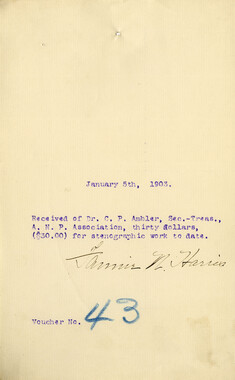
The 559 acres in Cataloochee tracts 224 and 224a were owned by Jarvis L. Palmer. The Palmer House is among the few preserved structures that remain today in Big Cataloochee. While, in general, the Great Smoky Mountains region was sparsely populated, the Cataloochee Valley remained an exception. By 1900, the population of Cataloochee had grown to 1,000 residents living in hundreds of log and frame homes. A few historic buildings have been preserved on site, including two churches, a school, several homes, and outbuildings. The North Carolina Park Commission was tasked with purchasing land for the Great Smoky Mountains National Park and people living in Cataloochee were among those displaced. Cataloochee families continue to return for annual reunions. In 2001, the National Park Service re-introduced elk into the valley.
-


Part of Collection
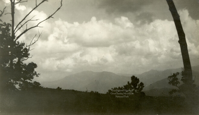
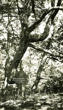
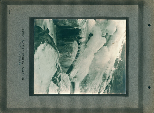
Great Smoky Mountains - A Park for America