- Canton Champion Fibre Company (2308)
- Cherokee Traditions (291)
- Civil War in Southern Appalachia (165)
- Craft Revival (1942)
- George Masa Collection (137)
- Great Smoky Mountains - A Park for America (2900)
- Highlights from Western Carolina University (422)
- Horace Kephart (941)
- Journeys Through Jackson (159)
- LGBTQIA+ Archive of Jackson County (85)
- Oral Histories of Western North Carolina (314)
- Picturing Appalachia (6797)
- Stories of Mountain Folk (413)
- Travel Western North Carolina (153)
- Western Carolina University Fine Art Museum Vitreograph Collection (129)
- Western Carolina University Herbarium (92)
- Western Carolina University: Making Memories (738)
- Western Carolina University Publications (2491)
- Western Carolina University Restricted Electronic Theses and Dissertations (146)
- Western North Carolina Regional Maps (71)
- World War II in Southern Appalachia (131)
- Allanstand Cottage Industries (62)
- Appalachian National Park Association (53)
- Bennett, Kelly, 1890-1974 (1463)
- Berry, Walter (76)
- Brasstown Carvers (40)
- Carver, George Washington, 1864?-1943 (26)
- Cathey, Joseph, 1803-1874 (1)
- Champion Fibre Company (233)
- Champion Paper and Fibre Company (297)
- Cherokee Indian Fair Association (16)
- Cherokee Language Program (22)
- Crowe, Amanda (40)
- Edmonston, Thomas Benton, 1842-1907 (7)
- Ensley, A. L. (Abraham Lincoln), 1865-1948 (275)
- Fromer, Irving Rhodes, 1913-1994 (70)
- George Butz (BFS 1907) (46)
- Goodrich, Frances Louisa (120)
- Grant, George Alexander, 1891-1964 (96)
- Heard, Marian Gladys (60)
- Kephart, Calvin, 1883-1969 (15)
- Kephart, Horace, 1862-1931 (313)
- Kephart, Laura, 1862-1954 (39)
- Laney, Gideon Thomas, 1889-1976 (439)
- Masa, George, 1881-1933 (61)
- McElhinney, William Julian, 1896-1953 (44)
- Niggli, Josephina, 1910-1983 (10)
- North Carolina Park Commission (105)
- Osborne, Kezia Stradley (9)
- Owens, Samuel Robert, 1918-1995 (11)
- Penland Weavers and Potters (36)
- Roberts, Vivienne (15)
- Roth, Albert, 1890-1974 (142)
- Schenck, Carl Alwin, 1868-1955 (1)
- Sherrill's Photography Studio (2565)
- Southern Highland Handicraft Guild (127)
- Southern Highlanders, Inc. (71)
- Stalcup, Jesse Bryson (46)
- Stearns, I. K. (213)
- Thompson, James Edward, 1880-1976 (226)
- United States. Indian Arts and Crafts Board (130)
- USFS (683)
- Vance, Zebulon Baird, 1830-1894 (1)
- Weaver, Zebulon, 1872-1948 (58)
- Western Carolina College (230)
- Western Carolina Teachers College (282)
- Western Carolina University (2008)
- Western Carolina University. Mountain Heritage Center (18)
- Whitman, Walt, 1819-1892 (10)
- Wilburn, Hiram Coleman, 1880-1967 (73)
- Williams, Isadora (3)
- Cain, Doreyl Ammons (0)
- Crittenden, Lorraine (0)
- Rhodes, Judy (0)
- Smith, Edward Clark (0)
- Appalachian Region, Southern (2929)
- Asheville (N.C.) (1944)
- Avery County (N.C.) (26)
- Blount County (Tenn.) (195)
- Buncombe County (N.C.) (1680)
- Cherokee County (N.C.) (283)
- Clay County (N.C.) (556)
- Graham County (N.C.) (238)
- Great Smoky Mountains National Park (N.C. and Tenn.) (525)
- Haywood County (N.C.) (3571)
- Henderson County (N.C.) (70)
- Jackson County (N.C.) (4917)
- Knox County (Tenn.) (35)
- Knoxville (Tenn.) (13)
- Lake Santeetlah (N.C.) (10)
- Macon County (N.C.) (420)
- Madison County (N.C.) (216)
- McDowell County (N.C.) (39)
- Mitchell County (N.C.) (135)
- Polk County (N.C.) (35)
- Qualla Boundary (982)
- Rutherford County (N.C.) (78)
- Swain County (N.C.) (2185)
- Transylvania County (N.C.) (270)
- Watauga County (N.C.) (12)
- Waynesville (N.C.) (86)
- Yancey County (N.C.) (72)
- Aerial Photographs (3)
- Aerial Views (60)
- Albums (books) (4)
- Articles (1)
- Artifacts (object Genre) (228)
- Bibliographies (1)
- Biography (general Genre) (2)
- Cards (information Artifacts) (38)
- Clippings (information Artifacts) (191)
- Copybooks (instructional Materials) (3)
- Crafts (art Genres) (622)
- Depictions (visual Works) (21)
- Design Drawings (1)
- Drawings (visual Works) (185)
- Envelopes (73)
- Exhibitions (events) (1)
- Facsimiles (reproductions) (1)
- Fiction (general Genre) (4)
- Financial Records (12)
- Fliers (printed Matter) (67)
- Glass Plate Negatives (381)
- Guidebooks (2)
- Internegatives (10)
- Interviews (815)
- Land Surveys (102)
- Letters (correspondence) (1013)
- Manuscripts (documents) (618)
- Maps (documents) (177)
- Memorandums (25)
- Minutes (administrative Records) (59)
- Negatives (photographs) (6090)
- Newsletters (1290)
- Newspapers (2)
- Notebooks (8)
- Occupation Currency (1)
- Paintings (visual Works) (1)
- Pen And Ink Drawings (1)
- Periodicals (193)
- Personal Narratives (10)
- Photographs (12976)
- Plans (maps) (1)
- Poetry (5)
- Portraits (4568)
- Postcards (329)
- Programs (documents) (181)
- Publications (documents) (2443)
- Questionnaires (65)
- Relief Prints (26)
- Sayings (literary Genre) (1)
- Scrapbooks (282)
- Sheet Music (2)
- Slides (photographs) (402)
- Songs (musical Compositions) (2)
- Sound Recordings (796)
- Specimens (92)
- Speeches (documents) (18)
- Tintypes (photographs) (8)
- Transcripts (322)
- Video Recordings (physical Artifacts) (23)
- Text Messages (0)
- A.L. Ensley Collection (275)
- Appalachian Industrial School Records (7)
- Appalachian National Park Association Records (336)
- Axley-Meroney Collection (2)
- Bayard Wootten Photograph Collection (20)
- Bethel Rural Community Organization Collection (7)
- Blumer Collection (5)
- C.W. Slagle Collection (20)
- Canton Area Historical Museum (2110)
- Carlos C. Campbell Collection (462)
- Cataloochee History Project (64)
- Cherokee Studies Collection (4)
- Daisy Dame Photograph Album (5)
- Daniel Boone VI Collection (1)
- Doris Ulmann Photograph Collection (112)
- Elizabeth H. Lasley Collection (1)
- Elizabeth Woolworth Szold Fleharty Collection (4)
- Frank Fry Collection (95)
- George Masa Collection (173)
- Gideon Laney Collection (452)
- Hazel Scarborough Collection (2)
- Hiram C. Wilburn Papers (28)
- Historic Photographs Collection (236)
- Horace Kephart Collection (861)
- Humbard Collection (33)
- Hunter and Weaver Families Collection (1)
- I. D. Blumenthal Collection (4)
- Isadora Williams Collection (4)
- Jesse Bryson Stalcup Collection (47)
- Jim Thompson Collection (224)
- John B. Battle Collection (7)
- John C. Campbell Folk School Records (80)
- John Parris Collection (6)
- Judaculla Rock project (2)
- Kelly Bennett Collection (1482)
- Love Family Papers (11)
- Major Wiley Parris Civil War Letters (3)
- Map Collection (12)
- McFee-Misemer Civil War Letters (34)
- Mountain Heritage Center Collection (4)
- Norburn - Robertson - Thomson Families Collection (44)
- Pauline Hood Collection (7)
- Pre-Guild Collection (2)
- Qualla Arts and Crafts Mutual Collection (12)
- R.A. Romanes Collection (681)
- Rosser H. Taylor Collection (1)
- Samuel Robert Owens Collection (94)
- Sara Madison Collection (144)
- Sherrill Studio Photo Collection (2558)
- Smoky Mountains Hiking Club Collection (616)
- Stories of Mountain Folk - Radio Programs (374)
- The Reporter, Western Carolina University (510)
- Venoy and Elizabeth Reed Collection (16)
- WCU Gender and Sexuality Oral History Project (32)
- WCU Mountain Heritage Center Oral Histories (25)
- WCU Oral History Collection - Mountain People, Mountain Lives (71)
- WCU Students Newspapers Collection (1923)
- Western North Carolina Tomorrow Black Oral History Project (69)
- William Williams Stringfield Collection (2)
- Zebulon Weaver Collection (109)
- African Americans (390)
- Appalachian Trail (35)
- Artisans (521)
- Cherokee art (84)
- Cherokee artists -- North Carolina (10)
- Cherokee language (21)
- Cherokee pottery (101)
- Cherokee women (208)
- Church buildings (190)
- Civilian Conservation Corps (U.S.) (111)
- College student newspapers and periodicals (2012)
- Dams (108)
- Dance (1023)
- Education (222)
- Floods (61)
- Folk music (1015)
- Forced removal, 1813-1903 (2)
- Forest conservation (220)
- Forests and forestry (1196)
- Gender nonconformity (4)
- Great Smoky Mountains National Park (N.C. and Tenn.) (181)
- Hunting (46)
- Landscape photography (25)
- Logging (119)
- Maps (83)
- Mines and mineral resources (9)
- North Carolina -- Maps (18)
- Paper industry (38)
- Postcards (255)
- Pottery (135)
- Railroad trains (72)
- Rural electrification -- North Carolina, Western (3)
- School integration -- Southern States (2)
- Segregation -- North Carolina, Western (5)
- Slavery (5)
- Sports (452)
- Storytelling (243)
- Waterfalls -- Great Smoky Mountains (N.C. and Tenn.) (66)
- Weaving -- Appalachian Region, Southern (280)
- Wood-carving -- Appalachian Region, Southern (328)
- World War, 1939-1945 (173)
Secretary of Agriculture report on watersheds

Secretary of Agriculture report on watersheds
NCWRA_019_12_04_07_01
Secretary of Agriculture report on watersheds
NCWRA_019_12_04_07_02
Secretary of Agriculture report on watersheds
NCWRA_019_12_04_07_03
Secretary of Agriculture report on watersheds
NCWRA_019_12_04_07_04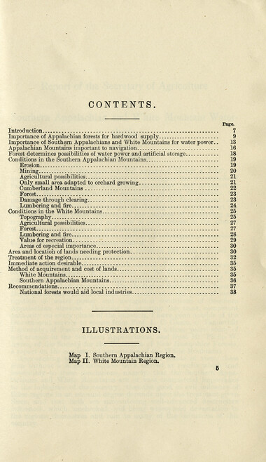
Secretary of Agriculture report on watersheds
NCWRA_019_12_04_07_05
Secretary of Agriculture report on watersheds
NCWRA_019_12_04_07_06
Secretary of Agriculture report on watersheds
NCWRA_019_12_04_07_07
Secretary of Agriculture report on watersheds
NCWRA_019_12_04_07_08
Secretary of Agriculture report on watersheds
NCWRA_019_12_04_07_09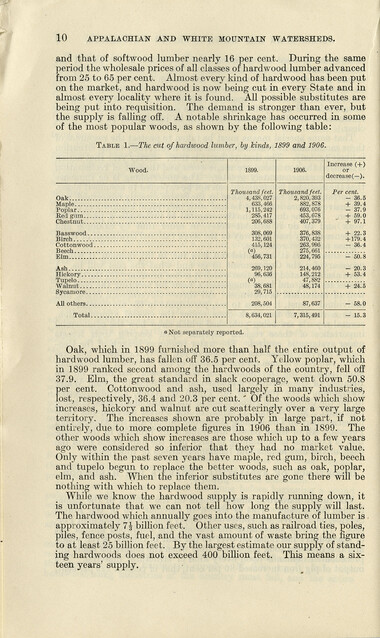
Secretary of Agriculture report on watersheds
NCWRA_019_12_04_07_10
Secretary of Agriculture report on watersheds
NCWRA_019_12_04_07_11
Secretary of Agriculture report on watersheds
NCWRA_019_12_04_07_12
Secretary of Agriculture report on watersheds
NCWRA_019_12_04_07_13
Secretary of Agriculture report on watersheds
NCWRA_019_12_04_07_14
Secretary of Agriculture report on watersheds
NCWRA_019_12_04_07_15
Secretary of Agriculture report on watersheds
NCWRA_019_12_04_07_16
Secretary of Agriculture report on watersheds
NCWRA_019_12_04_07_17
Secretary of Agriculture report on watersheds
NCWRA_019_12_04_07_18
Secretary of Agriculture report on watersheds
NCWRA_019_12_04_07_19
Secretary of Agriculture report on watersheds
NCWRA_019_12_04_07_20
Secretary of Agriculture report on watersheds
NCWRA_019_12_04_07_21
Secretary of Agriculture report on watersheds
NCWRA_019_12_04_07_22
Secretary of Agriculture report on watersheds
NCWRA_019_12_04_07_23
Secretary of Agriculture report on watersheds
NCWRA_019_12_04_07_24
Secretary of Agriculture report on watersheds
NCWRA_019_12_04_07_25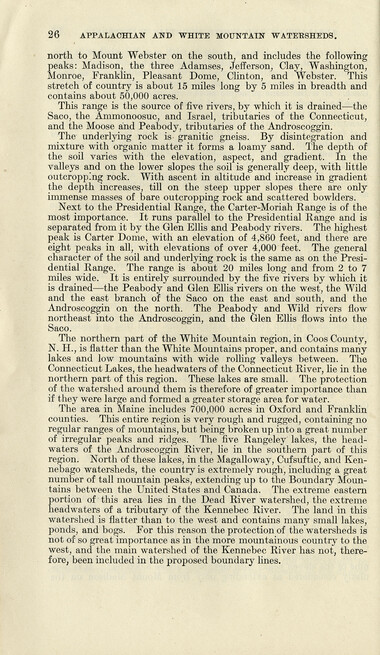
Secretary of Agriculture report on watersheds
NCWRA_019_12_04_07_26
Secretary of Agriculture report on watersheds
NCWRA_019_12_04_07_27
Secretary of Agriculture report on watersheds
NCWRA_019_12_04_07_28
Secretary of Agriculture report on watersheds
NCWRA_019_12_04_07_29
Secretary of Agriculture report on watersheds
NCWRA_019_12_04_07_30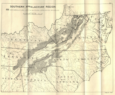
Secretary of Agriculture report on watersheds
NCWRA_019_12_04_07_30a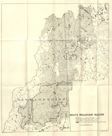
Secretary of Agriculture report on watersheds
NCWRA_019_12_04_07_30b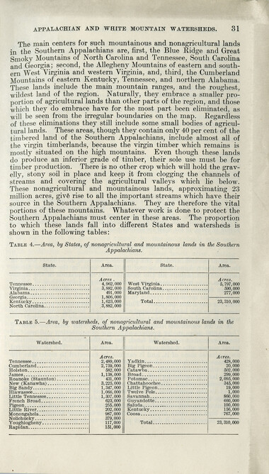
Secretary of Agriculture report on watersheds
NCWRA_019_12_04_07_31
Secretary of Agriculture report on watersheds
NCWRA_019_12_04_07_32
Secretary of Agriculture report on watersheds
NCWRA_019_12_04_07_33
Secretary of Agriculture report on watersheds
NCWRA_019_12_04_07_34
Secretary of Agriculture report on watersheds
NCWRA_019_12_04_07_35
Secretary of Agriculture report on watersheds
NCWRA_019_12_04_07_36
Secretary of Agriculture report on watersheds
NCWRA_019_12_04_07_37
Secretary of Agriculture report on watersheds
NCWRA_019_12_04_07_38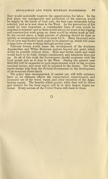
Secretary of Agriculture report on watersheds
NCWRA_019_12_04_07_39Item’s are ‘child’ level descriptions to ‘parent’ objects, (e.g. one page of a whole book).
-
-
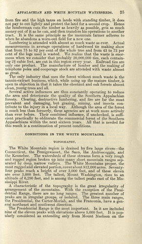
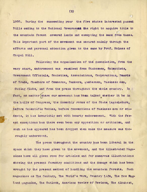
APPALACHIAN AND WHITE MOUNTAIN WATERSHEDS. 25 from fire and the high taxes on lands with standing timber, it does not pay to cut lightly and protect the land for a second crop. Hence the lumberman cuts the timber as heavily as possible, gets as much money out of it as he can, and then transfers his operations to another tract. It is the same principle as the mountain farmer adheres to when he abandons a worn-out field for a new one. Lumbering is attended with almost as much waste as ever. Actual measurements in average operations of hardwood tie making show that from 75 to 82 per cent of the whole tree and from 43 to 73 per cent of the logs used is wasted. We realize that the waste is enormous when we consider that probably 20,000,000 ties, each containing 2| cubic feet, are cut in this region every year. Railroad ties are only one product. The manufacture of lumber and the making of telephone poles and cooperage stock are attended with waste almost as great. The only industry that uses the forest without much waste is the tannin-extract business, which, while using up the mature timber, is open to objection in that it takes the chestnut and oak forests almost clean, young trees and all. Several active influences are thus constantly operating to reduce the area and deteriorate the quality of the Southern Appalachian forests. Clearing, destructive lumbering, and fire are far the most prevalent and damaging, but grazing, mining, and insects contribute to the injury in a local way. Although the area of the forest is much less than formerly, these agencies are at work more actively than ever before. Their combined influence, if unchecked, is sufficient practically to obliterate the commercial forest of the Southern Appalachians within the next sixteen years. All that is needed for this result is a continuation of present conditions. CONDITIONS IN THE WHITE MOUNTAINS. TOPOGRAPHY. The White Mountain region is drained by five large rivers—the Connecticut, the Pemigewasset, the Saco, the Androscoggin, and the Kennebec. The watersheds of these streams form a very rough and rugged region broken up into many short mountain ranges separated by deep, narrow valleys. The White Mountains proper, the most rugged and elevated portion, cover about 812,000 acres. Seventy- four peaks reach a height of over 3,000 feet, and of these eleven are over 5,000 feet. The tallest, Mount Washington, rises to an altitude of 6,290 feet, and is among the tallest peaks east of the Mississippi River. A characteristic of the topography is the great irregularity of arrangement of the mountains. With the exception of the Presidential Range, there are no long ranges. The greatest number of peaks are in irregular groups, or isolated. The three main ranges, the Presidential, the Carter-Moriah, and the Franconia, have a general northeast and southwest direction. The Presidential Range is the most important. In it are included nine of the eleven peaks with elevations above 5,000 feet. It is popularly considered as extending only from Mount Madison on the
Object’s are ‘parent’ level descriptions to ‘children’ items, (e.g. a book with pages).
-
This 41-page “Report of the Secretary of Agriculture on The Southern Appalachian and White Mountain Watersheds” is in the collection of the Appalachian National Park Association records. The Senate report was written in 1907. Even before the dawn of the 20th century, the association raised awareness of the importance of forests to water.
-
Related items
-
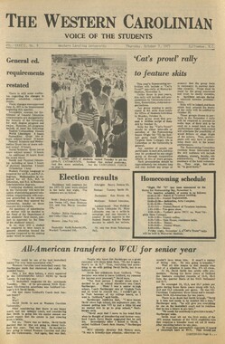
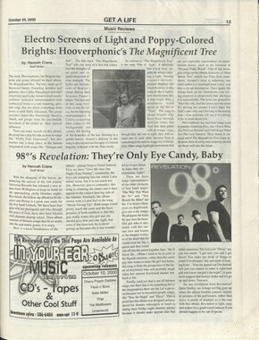
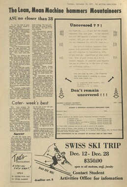
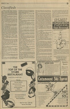
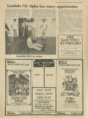
Western Carolinian Volume 13 Number 06
-
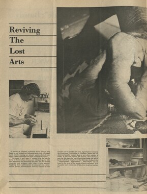
Twelvth Annual Session of the Penland School of Crafts 1941 - page 7
-
Western Carolinian Volume 42 Number 60

-
Cullowhee Yodel Volume 08 Number 07
-
Western Carolinian Volume 43 Number 16
-
Western Carolinian Volume 48 Number 04
-
Western Carolinian Volume 40 Number 20
-
Western Carolinian Volume 16 Number 05
-
Western Carolinian Volume 45 (46) Number 23
-
Western Carolinian Volume 16 Number 02 (11)
-
Western Carolinian Volume 44 Number 31

-
Western Carolinian Volume 29 Number 12
-
Western Carolinian Volume 60 Number 21
-
Western Carolinian Volume 42 Number 19

-
Western Carolinian Volume 37 Number 09
-
Western Carolinian Volume 65 (66) Number 07
-
Western Carolinian Volume 37 Number 06
-
Western Carolinian Volume 44 Number 17

-
Western Carolinian Volume 46 Number 19
-
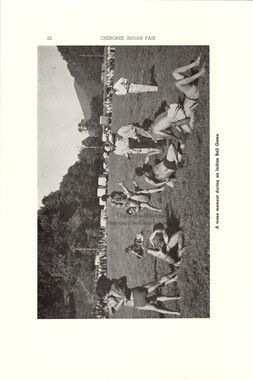
Cherokee Indian Fair 1948
-
Western Carolinian Volume 25 Number 11
-
Western Carolinian Volume 50 Number 13
-
Western Carolinian January 19, 1942
-
Western Carolinian Volume 79 Number 05

-
The Canton Enterprise Volume 13 Number 03
-
Western Carolinian Volume 63 Number 02
-
Western Carolinian Volume 71 Number 05
-
Civilian Conservation Corps Annual: District "C"
-
Western Carolinian Volume 44 Number 09
-
Western Carolinian Volume 62 Number 17
-
Western Carolinian Volume 38 Number 06
-
Western Carolinian Volume 54 Number 11
Part of Collection
Great Smoky Mountains - A Park for America
-
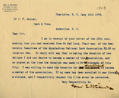
Subscriptions received by the Appalachian National Park Association
-
Cataloochee tract 219: Milia Palmer
-
Smokies roadway

-
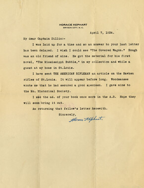
Correspondence regarding article on rifles
-
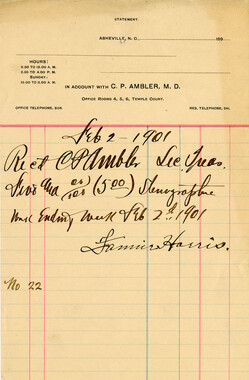
Financial receipts and expenditures, 1901
-
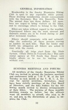
Handbook/ 1934/ Smoky Mountains Hiking Club
-
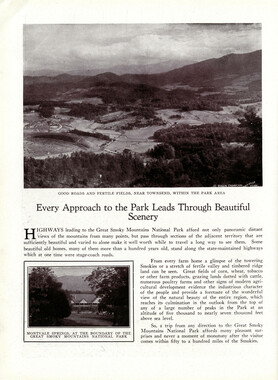
Great Smoky Mountains National Park / Land of the Everlasting Hills
-
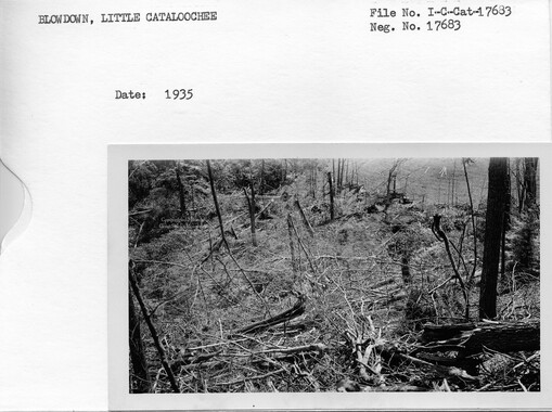
Cataloochee: fields
-
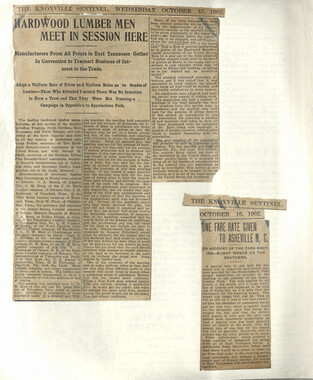
Appalachian National Park Association Newspaper Clippings, 1902-1907, 1925, 1928
-
Minutes of Meetings of the Appalachian National Park Association

-
National Park in the Great Smoky Mountains

-
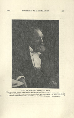
Report of the Secretary of Agriculture in relation to the forests, rivers, and mountains of the southern Appalachian region

-
Financial receipts and expenditures, 1902

-
Appalachian National Park Association Newspaper Clippings, 1899-1902
-
Handbook/ 1933/ Smoky Mountains Hiking Club

-
Editorial requests to support an Appalachian National Park
-
Correspondence: C. P. Ambler to Jacob Ambler
-
Mountain landscape

-
Cataloochee tract 251: James H. Hannah
-
Cataloochee tract 289: Spence Phillips

-
Speech in support of an Appalachian National Park
-
Appalachian National Park Association Newspaper Clippings, 1902-1907, 1925, 1928

-
Appalachian National Park Association Newspaper Clippings, 1902-1907, 1925, 1928
-
Handbook/ 1933/ Smoky Mountains Hiking Club

-
Climatic Treatment of Disease: Western North Carolina as a Health Resort

-
Handbook/ 1933/ Smoky Mountains Hiking Club

-
Cataloochee tract 231: W. G. B. Messer

-
Appalachian National Park: Synopsis of work accomplished

-
Unaka and the Pisgah
-
Program of hikes for 1930/ Smoky Mountains Hiking Club
-
Report of the North Carolina Park Commission

-
Appalachian National Park Association Newspaper Clippings, 1899-1902
