- Canton Champion Fibre Company (2308)
- Cherokee Traditions (291)
- Civil War in Southern Appalachia (165)
- Craft Revival (1942)
- Great Smoky Mountains - A Park for America (2946)
- Highlights from Western Carolina University (430)
- Horace Kephart (941)
- Journeys Through Jackson (159)
- LGBTQIA+ Archive of Jackson County (85)
- Oral Histories of Western North Carolina (314)
- Picturing Appalachia (6873)
- Stories of Mountain Folk (413)
- Travel Western North Carolina (160)
- Western Carolina University Fine Art Museum Vitreograph Collection (129)
- Western Carolina University Herbarium (92)
- Western Carolina University: Making Memories (738)
- Western Carolina University Publications (2491)
- Western Carolina University Restricted Electronic Theses and Dissertations (146)
- Western North Carolina Regional Maps (71)
- World War II in Southern Appalachia (131)
- Allanstand Cottage Industries (62)
- Appalachian National Park Association (53)
- Bennett, Kelly, 1890-1974 (1463)
- Berry, Walter (76)
- Brasstown Carvers (40)
- Carver, George Washington, 1864?-1943 (26)
- Cathey, Joseph, 1803-1874 (1)
- Champion Fibre Company (233)
- Champion Paper and Fibre Company (297)
- Cherokee Indian Fair Association (16)
- Cherokee Language Program (22)
- Crowe, Amanda (40)
- Edmonston, Thomas Benton, 1842-1907 (7)
- Ensley, A. L. (Abraham Lincoln), 1865-1948 (275)
- Fromer, Irving Rhodes, 1913-1994 (70)
- George Butz (BFS 1907) (46)
- Goodrich, Frances Louisa (120)
- Grant, George Alexander, 1891-1964 (96)
- Heard, Marian Gladys (60)
- Kephart, Calvin, 1883-1969 (15)
- Kephart, Horace, 1862-1931 (313)
- Kephart, Laura, 1862-1954 (39)
- Laney, Gideon Thomas, 1889-1976 (439)
- Masa, George, 1881-1933 (61)
- McElhinney, William Julian, 1896-1953 (44)
- Niggli, Josephina, 1910-1983 (10)
- North Carolina Park Commission (105)
- Osborne, Kezia Stradley (9)
- Owens, Samuel Robert, 1918-1995 (11)
- Penland Weavers and Potters (36)
- Roberts, Vivienne (15)
- Roth, Albert, 1890-1974 (142)
- Schenck, Carl Alwin, 1868-1955 (1)
- Sherrill's Photography Studio (2565)
- Southern Highland Handicraft Guild (127)
- Southern Highlanders, Inc. (71)
- Stalcup, Jesse Bryson (46)
- Stearns, I. K. (213)
- Thompson, James Edward, 1880-1976 (226)
- United States. Indian Arts and Crafts Board (130)
- USFS (683)
- Vance, Zebulon Baird, 1830-1894 (1)
- Weaver, Zebulon, 1872-1948 (58)
- Western Carolina College (230)
- Western Carolina Teachers College (282)
- Western Carolina University (2008)
- Western Carolina University. Mountain Heritage Center (18)
- Whitman, Walt, 1819-1892 (10)
- Wilburn, Hiram Coleman, 1880-1967 (73)
- Williams, Isadora (3)
- Cain, Doreyl Ammons (0)
- Crittenden, Lorraine (0)
- Rhodes, Judy (0)
- Smith, Edward Clark (0)
- Appalachian Region, Southern (2569)
- Asheville (N.C.) (1923)
- Avery County (N.C.) (26)
- Blount County (Tenn.) (195)
- Buncombe County (N.C.) (1672)
- Cherokee County (N.C.) (283)
- Clay County (N.C.) (555)
- Graham County (N.C.) (236)
- Great Smoky Mountains National Park (N.C. and Tenn.) (519)
- Haywood County (N.C.) (3569)
- Henderson County (N.C.) (70)
- Jackson County (N.C.) (4912)
- Knox County (Tenn.) (35)
- Knoxville (Tenn.) (13)
- Lake Santeetlah (N.C.) (10)
- Macon County (N.C.) (420)
- Madison County (N.C.) (215)
- McDowell County (N.C.) (39)
- Mitchell County (N.C.) (132)
- Polk County (N.C.) (35)
- Qualla Boundary (982)
- Rutherford County (N.C.) (76)
- Swain County (N.C.) (2182)
- Transylvania County (N.C.) (270)
- Watauga County (N.C.) (12)
- Waynesville (N.C.) (86)
- Yancey County (N.C.) (72)
- Aerial Photographs (3)
- Aerial Views (60)
- Albums (books) (4)
- Articles (1)
- Artifacts (object Genre) (228)
- Bibliographies (1)
- Biography (general Genre) (2)
- Cards (information Artifacts) (38)
- Clippings (information Artifacts) (191)
- Copybooks (instructional Materials) (3)
- Crafts (art Genres) (622)
- Depictions (visual Works) (21)
- Design Drawings (1)
- Drawings (visual Works) (185)
- Envelopes (73)
- Exhibitions (events) (1)
- Facsimiles (reproductions) (1)
- Fiction (general Genre) (4)
- Financial Records (12)
- Fliers (printed Matter) (67)
- Glass Plate Negatives (381)
- Guidebooks (2)
- Internegatives (10)
- Interviews (815)
- Land Surveys (102)
- Letters (correspondence) (1013)
- Manuscripts (documents) (618)
- Maps (documents) (177)
- Memorandums (25)
- Minutes (administrative Records) (59)
- Negatives (photographs) (6090)
- Newsletters (1290)
- Newspapers (2)
- Notebooks (8)
- Occupation Currency (1)
- Paintings (visual Works) (1)
- Pen And Ink Drawings (1)
- Periodicals (193)
- Personal Narratives (10)
- Photographs (12976)
- Plans (maps) (1)
- Poetry (5)
- Portraits (4568)
- Postcards (329)
- Programs (documents) (181)
- Publications (documents) (2443)
- Questionnaires (65)
- Relief Prints (26)
- Sayings (literary Genre) (1)
- Scrapbooks (282)
- Sheet Music (2)
- Slides (photographs) (402)
- Songs (musical Compositions) (2)
- Sound Recordings (796)
- Specimens (92)
- Speeches (documents) (18)
- Tintypes (photographs) (8)
- Transcripts (322)
- Video Recordings (physical Artifacts) (23)
- Text Messages (0)
- A.L. Ensley Collection (275)
- Appalachian Industrial School Records (7)
- Appalachian National Park Association Records (336)
- Axley-Meroney Collection (2)
- Bayard Wootten Photograph Collection (20)
- Bethel Rural Community Organization Collection (7)
- Blumer Collection (5)
- C.W. Slagle Collection (20)
- Canton Area Historical Museum (2110)
- Carlos C. Campbell Collection (462)
- Cataloochee History Project (64)
- Cherokee Studies Collection (4)
- Daisy Dame Photograph Album (5)
- Daniel Boone VI Collection (1)
- Doris Ulmann Photograph Collection (112)
- Elizabeth H. Lasley Collection (1)
- Elizabeth Woolworth Szold Fleharty Collection (4)
- Frank Fry Collection (95)
- George Masa Collection (173)
- Gideon Laney Collection (452)
- Hazel Scarborough Collection (2)
- Hiram C. Wilburn Papers (28)
- Historic Photographs Collection (236)
- Horace Kephart Collection (861)
- Humbard Collection (33)
- Hunter and Weaver Families Collection (1)
- I. D. Blumenthal Collection (4)
- Isadora Williams Collection (4)
- Jesse Bryson Stalcup Collection (47)
- Jim Thompson Collection (224)
- John B. Battle Collection (7)
- John C. Campbell Folk School Records (80)
- John Parris Collection (6)
- Judaculla Rock project (2)
- Kelly Bennett Collection (1482)
- Love Family Papers (11)
- Major Wiley Parris Civil War Letters (3)
- Map Collection (12)
- McFee-Misemer Civil War Letters (34)
- Mountain Heritage Center Collection (4)
- Norburn - Robertson - Thomson Families Collection (44)
- Pauline Hood Collection (7)
- Pre-Guild Collection (2)
- Qualla Arts and Crafts Mutual Collection (12)
- R.A. Romanes Collection (681)
- Rosser H. Taylor Collection (1)
- Samuel Robert Owens Collection (94)
- Sara Madison Collection (144)
- Sherrill Studio Photo Collection (2558)
- Smoky Mountains Hiking Club Collection (616)
- Stories of Mountain Folk - Radio Programs (374)
- The Reporter, Western Carolina University (510)
- Venoy and Elizabeth Reed Collection (16)
- WCU Gender and Sexuality Oral History Project (32)
- WCU Mountain Heritage Center Oral Histories (25)
- WCU Oral History Collection - Mountain People, Mountain Lives (71)
- WCU Students Newspapers Collection (1923)
- Western North Carolina Tomorrow Black Oral History Project (69)
- William Williams Stringfield Collection (2)
- Zebulon Weaver Collection (109)
- African Americans (390)
- Appalachian Trail (35)
- Artisans (521)
- Cherokee art (84)
- Cherokee artists -- North Carolina (10)
- Cherokee language (21)
- Cherokee pottery (101)
- Cherokee women (208)
- Church buildings (189)
- Civilian Conservation Corps (U.S.) (111)
- College student newspapers and periodicals (2012)
- Dams (107)
- Dance (1023)
- Education (222)
- Floods (61)
- Folk music (1015)
- Forced removal, 1813-1903 (2)
- Forest conservation (220)
- Forests and forestry (1184)
- Gender nonconformity (4)
- Great Smoky Mountains National Park (N.C. and Tenn.) (181)
- Hunting (45)
- Landscape photography (25)
- Logging (119)
- Maps (83)
- Mines and mineral resources (8)
- North Carolina -- Maps (18)
- Paper industry (38)
- Postcards (255)
- Pottery (135)
- Railroad trains (72)
- Rural electrification -- North Carolina, Western (3)
- School integration -- Southern States (2)
- Segregation -- North Carolina, Western (5)
- Slavery (5)
- Sports (452)
- Storytelling (243)
- Waterfalls -- Great Smoky Mountains (N.C. and Tenn.) (66)
- Weaving -- Appalachian Region, Southern (280)
- Wood-carving -- Appalachian Region, Southern (328)
- World War, 1939-1945 (173)
Myron H. Avery letter, May 17, 1932, page 5
Myron H. Avery letter, May 17, 1932, page 1
HL_MSS80_24_01_13_08_01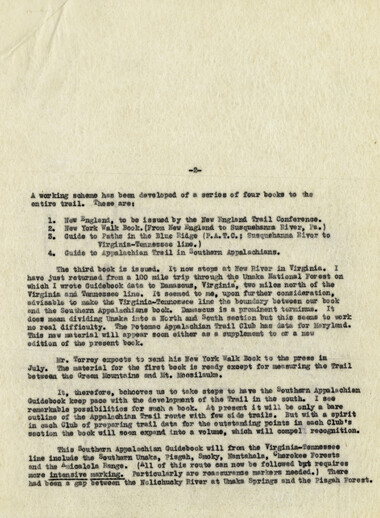
Myron H. Avery letter, May 17, 1932, page 2
HL_MSS80_24_01_13_08_02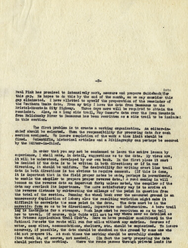
Myron H. Avery letter, May 17, 1932, page 3
HL_MSS80_24_01_13_08_03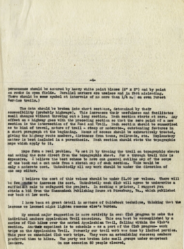
Myron H. Avery letter, May 17, 1932, page 4
HL_MSS80_24_01_13_08_04
Myron H. Avery letter, May 17, 1932, page 5
HL_MSS80_24_01_13_08_05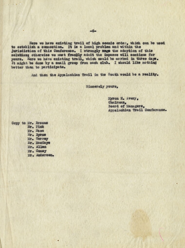
Myron H. Avery letter, May 17, 1932, page 6
HL_MSS80_24_01_13_08_06Item’s are ‘child’ level descriptions to ‘parent’ objects, (e.g. one page of a whole book).
-
-
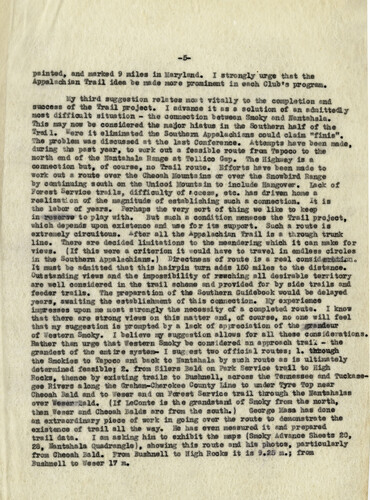
painted, sad «srt»d § miles in Maryland. I strongly'urge that the Appalftehisa frail idea be mad* mere prominent ia each Slab's program. ly third suggest! ©a relates oust vitally ft* the sempietiea m& success ef the frail project. 1 advance it ss • solution of a& aAaittedly s**t difficult situation - the connection esteem Smoky and Isatehala. %ls may now be considered the a*$jff hiatus in the Southern half of the 3**11* »ere it elimljwted the Southern App*leehiai* could claim **fiaisw, 'She problem wee discussed at the last Conference, attempts have been made, during the past year, to work out a feasible rout© from fapoc© to the north end ef the faatshala Bang* at fell lee Hep. fhe Highway is a. connection but, of course, no trail route. Efforts have been made te work out * route mm the Ohecah p&mtains er over the Snowbird Bungs by continuing south on the Unicoi Mounts in to include laagover, ^,ck of forest Service trails, difficulty ©f tec**s, etc. has driven hoae a realisation of the magnitude of establishing such a connection, it is the labor of years. Perhaps the very sort of thing we like to keep ia re*ara*> te play with. But such m condition menaces the frail project, which depend* upon existence ana" use for it* support. S&eh a route is axtreajely circuitous. *f**r all the Appalachian frail is a through trunk line, there are decided limitations to the a»aaderiag which it can make for views. {If this were a criterion it should have to travel ia endless circles ia the ®m0mm ApiAlaehians.) B&eetnesa of route is * real seacldegdsdsUuao It must be admitted that this hairpin tern adds ISO miles to the distance, ^utstanding views and the impossibility of reaching all desirable territory are well considered in the trail scheme and provided for Tsj side trails •*» feeder trails. The preparation of the Southern Suidebook would be delayed .years, awaiting the establishment of this connection. Sy experience impresses upon me stoat strongly the necessity of a completed rent** I know met there ere strong views on this matter and, of course, no one will feel that my suggestion is prompted by a lack of appreciation of the ejrssAmr of western S®oky. I believe m suggestion allows for ail these considerations. Bather than urge that Western Smoky be considered an approach trail - the grandest of the entire system- I sag est two offieis 1 routes s I. through the Smokies to lapoco sM beck to laatahals by such route as is ultimately detarffiiaad feasible! E. from Silers Said on Perk Service trail to High Rocks, thence by existing trail® to lushaall, across the feraieesee and fuekase- gee Rivers along the Srsham-Oherekse Scanty Line to wader fyre fop near Oheoah Bald and to >'*s*r and on Forest Sorvic® trail through the lantahala* over '****! iTiiTiT (If LeContc is me gr*jtd****d of Smoky from the north, them feaer sad Chsosh Balds are from the south.) Seorge las* has done m extraordinary piece of work in going aver the route to demonstrate the existence of trail ell -fee way. H has even measured it end prepared trail data, I am asking him to exhibit the saps |Smoky Advance Sheets 10, 28, fcatahale Quedraagl*), showing this route and Ms photos, particularly from Gheoah Bald. From Bushnell to High Bocks it is 9,25 a.; from Bushnell to laser 17 m.
Object’s are ‘parent’ level descriptions to ‘children’ items, (e.g. a book with pages).
-
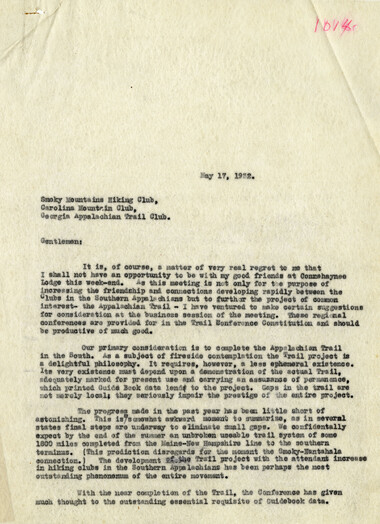
In a letter to the Smoky Mountains Hiking Club, the Carolina Mountain Club, and the Georgia Appalachian Trail Club on May 17, 1932, Myron A. Avery lays out specifics and suggestions regarding the completion of the Appalachian Trail in the south and a guide book for the Southern Appalachian section.
-
Related items
-
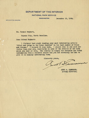
Arno B. Cammerer to Horace Kephart, December 19, 1928
-
Marc Woodmansee to Horace Kephart, January 26, 1919, page 2

-
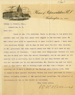
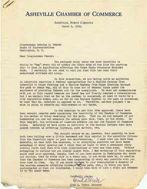
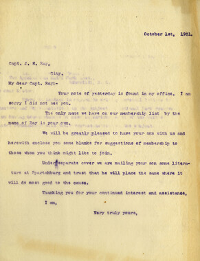
Correspondence regarding 1901 meeting

-
Correspondence regarding 1901 meeting

-
Laura Kephart to Leonard Kephart, March 26, 1934, page 2
-
Correspondence regarding employment

-
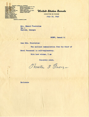
Walter Franklin George to Mrs. Preetorius, July 25, 1942
-
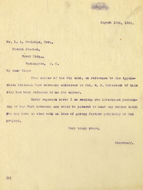
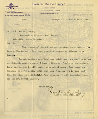
Requests for information on Appalachian National Park
-
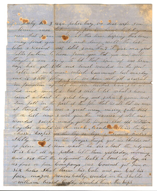
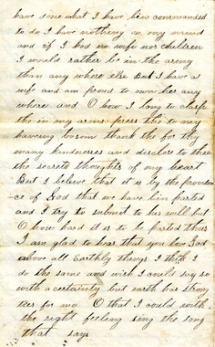
R.P. Kelly to "Dear Father and Mother and Sisters," September 16, 1862

-
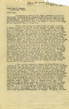
Calvin I. Kephart to Judge John W. Kephart, September 12, 1923
-
Letters supporting Appalachian National Park movement

-
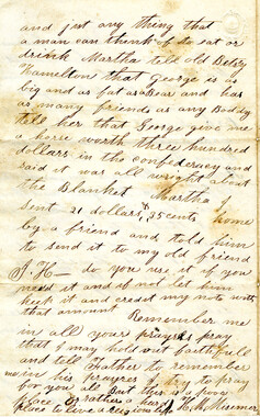
H. M. Misemer to wife Martha, June 5, 1863, page 4
-
Legislation on behalf of the Appalachian National Park
-
James R. Thomas to Captain James W. Terrell, December 8, 1888

-
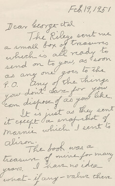
Laura Kephart to George Kephart, February 19, 1951
-
Requests for information on Appalachian National Park
-
Memorial presentation to Congress
-
Correspondence between Zebulon Weaver, Fred L. Weede, W. H. Woodbury, David C. Chapman, Mark Squires, Junius G. Adams, March 1932
-
Horace Kephart to Zebulon Weaver, January 13, 1925

-
Correspondence between H. C. Wilburn and Zebulon Weaver, 1933

-
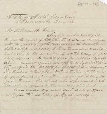
L. R. Weaver to William H. Thomas, April 22, 1867, page 1
-
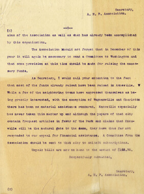
Subscriptions received by the Appalachian National Park Association
-
Zebulon Weaver to Horace Kephart, December 19, 1924, page 3

-
Frances Elvira Owens to Samuel Robert Owens, October 21
-
Wiley Parris to Jane Parris, July 3, 1862
-
Requests for information on Appalachian National Park

-
Theodore Marvin to Horace Kephart, December 16, 1926

-
H. M. Misemer to wife Martha, July 24, 1864, page 2
-
Correspondence regarding 1901 meeting
-
Laura Kephart to Leonard Kephart, May 3, 1945, page 1

-
Wiley Parris to Jane Parris, April 13, 1862

-
G. J. Huntley to friends, January 22, 1862

Part of Collection
Horace Kephart
-
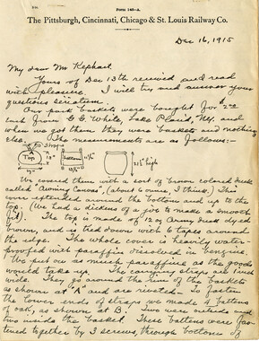
Water Supply of Secret Camp
-
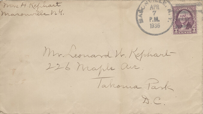
Laura Kephart to Leonard Kephart, April 7, 1936
-
Laura Kephart to Leonard Kephart, April 5, 1934, page 4

-
Horace Kephart Journal 22

-
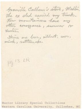
Granville Calhoun's store, Medlin
-
Laura Kephart to Leonard Kephart, September 16, 1933, page 3
-
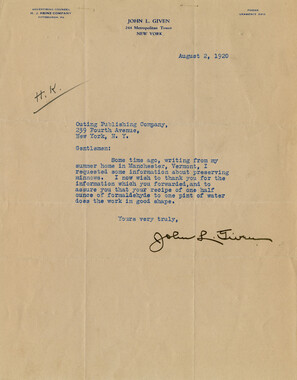
John L. Given to Outing Publishing Company, August 2, 1920
-
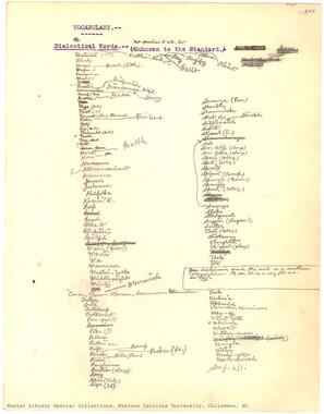
Vocabulary
-
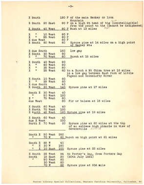
Field Book of the Survey of the State Line between North Carolina and Tennessee, run in 1821 by William Davenport
-
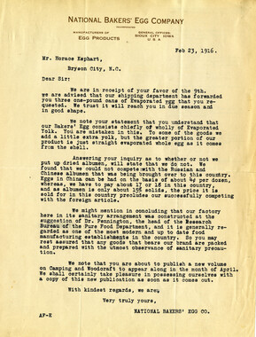
National Bakers' Egg Company to Horace Kephart, February 23, 1916, page 1
-
Elmo W. Brim to Horace Kephart, October 23, 1921, page 3
-
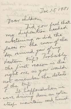
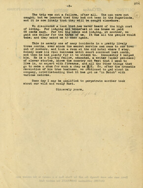
Laura Kephart to Dear children, December 15, 1951
-
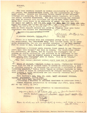
Dialect
-
Cornelia Moore to Leonard Kephart, March 28, 1935

-
Mary Augusta Clark to Horace Kephart, November 17, 1923, page 2

-
Laura Kephart to George Kephart, December 24, 1951, page 1

-
Horace Kephart to Albert Britt, August 23, 1919, page 3
-
Camping and Woodcraft draft page

-
Laura Kephart to Leonard Kephart, September 16, 1933

-
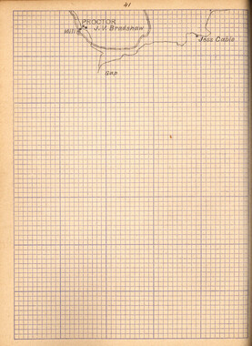
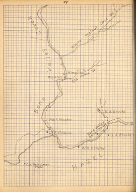
Map cross section book
-
Packing Food - Tins

-
Horace Kephart and friends at supper in the Hall Cabin

-
Laura Kephart to Leonard Kephart, December 6, 1948, page 3

-
Trout fishing, Falls of the Tuckaseegee

-
Visitors
-
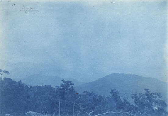
Attempted views from summit
-
Listening to the word
-
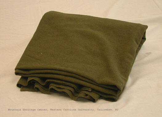
Green woolen blanket
-
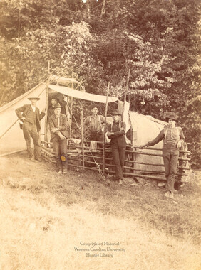
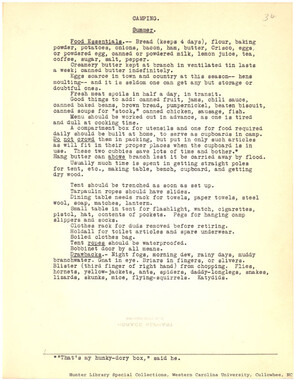
Camping. Summer.
-
Map cross section book
-
Frank L. Miller to Horace Kephart, December 16, 1915
-
Young man seated in front of cabin
