- Canton Champion Fibre Company (2308)
- Cherokee Traditions (292)
- Civil War in Southern Appalachia (165)
- Craft Revival (1942)
- Great Smoky Mountains - A Park for America (2766)
- Highlights from Western Carolina University (430)
- Horace Kephart (941)
- Journeys Through Jackson (154)
- LGBTQIA+ Archive of Jackson County (85)
- Oral Histories of Western North Carolina (314)
- Picturing Appalachia (6772)
- Stories of Mountain Folk (413)
- Travel Western North Carolina (160)
- Western Carolina University Fine Art Museum Vitreograph Collection (129)
- Western Carolina University Herbarium (92)
- Western Carolina University: Making Memories (708)
- Western Carolina University Publications (2283)
- Western Carolina University Restricted Electronic Theses and Dissertations (146)
- Western North Carolina Regional Maps (71)
- World War II in Southern Appalachia (131)
- Allanstand Cottage Industries (62)
- Appalachian National Park Association (53)
- Bennett, Kelly, 1890-1974 (1388)
- Berry, Walter (76)
- Brasstown Carvers (40)
- Carver, George Washington, 1864?-1943 (26)
- Cathey, Joseph, 1803-1874 (1)
- Champion Fibre Company (233)
- Champion Paper and Fibre Company (297)
- Cherokee Indian Fair Association (16)
- Cherokee Language Program (22)
- Crowe, Amanda (40)
- Edmonston, Thomas Benton, 1842-1907 (7)
- Ensley, A. L. (Abraham Lincoln), 1865-1948 (275)
- Fromer, Irving Rhodes, 1913-1994 (70)
- George Butz (BFS 1907) (46)
- Goodrich, Frances Louisa (120)
- Grant, George Alexander, 1891-1964 (96)
- Heard, Marian Gladys (60)
- Kephart, Calvin, 1883-1969 (15)
- Kephart, Horace, 1862-1931 (313)
- Kephart, Laura, 1862-1954 (39)
- Laney, Gideon Thomas, 1889-1976 (439)
- Masa, George, 1881-1933 (61)
- McElhinney, William Julian, 1896-1953 (44)
- Niggli, Josephina, 1910-1983 (10)
- North Carolina Park Commission (105)
- Osborne, Kezia Stradley (9)
- Owens, Samuel Robert, 1918-1995 (11)
- Penland Weavers and Potters (36)
- Roberts, Vivienne (15)
- Roth, Albert, 1890-1974 (142)
- Schenck, Carl Alwin, 1868-1955 (1)
- Sherrill's Photography Studio (2565)
- Southern Highland Handicraft Guild (127)
- Southern Highlanders, Inc. (71)
- Stalcup, Jesse Bryson (46)
- Stearns, I. K. (213)
- Thompson, James Edward, 1880-1976 (226)
- United States. Indian Arts and Crafts Board (130)
- USFS (683)
- Vance, Zebulon Baird, 1830-1894 (1)
- Weaver, Zebulon, 1872-1948 (58)
- Western Carolina College (230)
- Western Carolina Teachers College (282)
- Western Carolina University (1794)
- Western Carolina University. Mountain Heritage Center (18)
- Whitman, Walt, 1819-1892 (10)
- Wilburn, Hiram Coleman, 1880-1967 (73)
- Williams, Isadora (3)
- Cain, Doreyl Ammons (0)
- Crittenden, Lorraine (0)
- Rhodes, Judy (0)
- Smith, Edward Clark (0)
- Appalachian Region, Southern (2569)
- Asheville (N.C.) (1923)
- Avery County (N.C.) (26)
- Blount County (Tenn.) (161)
- Buncombe County (N.C.) (1672)
- Cherokee County (N.C.) (283)
- Clay County (N.C.) (555)
- Graham County (N.C.) (233)
- Great Smoky Mountains National Park (N.C. and Tenn.) (519)
- Haywood County (N.C.) (3524)
- Henderson County (N.C.) (70)
- Jackson County (N.C.) (4694)
- Knox County (Tenn.) (25)
- Knoxville (Tenn.) (12)
- Lake Santeetlah (N.C.) (10)
- Macon County (N.C.) (420)
- Madison County (N.C.) (212)
- McDowell County (N.C.) (39)
- Mitchell County (N.C.) (132)
- Polk County (N.C.) (35)
- Qualla Boundary (981)
- Rutherford County (N.C.) (76)
- Swain County (N.C.) (2115)
- Transylvania County (N.C.) (270)
- Watauga County (N.C.) (12)
- Waynesville (N.C.) (84)
- Yancey County (N.C.) (72)
- Aerial Photographs (3)
- Aerial Views (60)
- Albums (books) (4)
- Articles (1)
- Artifacts (object Genre) (228)
- Bibliographies (1)
- Biography (general Genre) (2)
- Cards (information Artifacts) (38)
- Clippings (information Artifacts) (191)
- Crafts (art Genres) (622)
- Depictions (visual Works) (21)
- Design Drawings (1)
- Drawings (visual Works) (184)
- Envelopes (73)
- Facsimiles (reproductions) (1)
- Fiction (general Genre) (4)
- Financial Records (12)
- Fliers (printed Matter) (67)
- Glass Plate Negatives (381)
- Guidebooks (2)
- Internegatives (10)
- Interviews (815)
- Land Surveys (102)
- Letters (correspondence) (1013)
- Manuscripts (documents) (618)
- Maps (documents) (177)
- Memorandums (25)
- Minutes (administrative Records) (59)
- Negatives (photographs) (5835)
- Newsletters (1285)
- Newspapers (2)
- Occupation Currency (1)
- Paintings (visual Works) (1)
- Pen And Ink Drawings (1)
- Periodicals (193)
- Personal Narratives (10)
- Photographs (12976)
- Plans (maps) (1)
- Poetry (6)
- Portraits (4533)
- Postcards (329)
- Programs (documents) (151)
- Publications (documents) (2236)
- Questionnaires (65)
- Scrapbooks (282)
- Sheet Music (2)
- Slides (photographs) (402)
- Songs (musical Compositions) (2)
- Sound Recordings (796)
- Specimens (92)
- Speeches (documents) (15)
- Tintypes (photographs) (8)
- Transcripts (322)
- Video Recordings (physical Artifacts) (23)
- Vitreographs (129)
- Text Messages (0)
- A.L. Ensley Collection (275)
- Appalachian Industrial School Records (7)
- Appalachian National Park Association Records (336)
- Axley-Meroney Collection (2)
- Bayard Wootten Photograph Collection (20)
- Bethel Rural Community Organization Collection (7)
- Blumer Collection (5)
- C.W. Slagle Collection (20)
- Canton Area Historical Museum (2110)
- Carlos C. Campbell Collection (282)
- Cataloochee History Project (64)
- Cherokee Studies Collection (4)
- Daisy Dame Photograph Album (5)
- Daniel Boone VI Collection (1)
- Doris Ulmann Photograph Collection (112)
- Elizabeth H. Lasley Collection (1)
- Elizabeth Woolworth Szold Fleharty Collection (4)
- Frank Fry Collection (95)
- George Masa Collection (173)
- Gideon Laney Collection (452)
- Hazel Scarborough Collection (2)
- Hiram C. Wilburn Papers (28)
- Historic Photographs Collection (236)
- Horace Kephart Collection (861)
- Humbard Collection (33)
- Hunter and Weaver Families Collection (1)
- I. D. Blumenthal Collection (4)
- Isadora Williams Collection (4)
- Jesse Bryson Stalcup Collection (47)
- Jim Thompson Collection (224)
- John B. Battle Collection (7)
- John C. Campbell Folk School Records (80)
- John Parris Collection (6)
- Judaculla Rock project (2)
- Kelly Bennett Collection (1407)
- Love Family Papers (11)
- Major Wiley Parris Civil War Letters (3)
- Map Collection (12)
- McFee-Misemer Civil War Letters (34)
- Mountain Heritage Center Collection (4)
- Norburn - Robertson - Thomson Families Collection (44)
- Pauline Hood Collection (7)
- Pre-Guild Collection (2)
- Qualla Arts and Crafts Mutual Collection (12)
- R.A. Romanes Collection (681)
- Rosser H. Taylor Collection (1)
- Samuel Robert Owens Collection (94)
- Sara Madison Collection (144)
- Sherrill Studio Photo Collection (2558)
- Smoky Mountains Hiking Club Collection (616)
- Stories of Mountain Folk - Radio Programs (374)
- The Reporter, Western Carolina University (510)
- Venoy and Elizabeth Reed Collection (16)
- WCU Gender and Sexuality Oral History Project (32)
- WCU Mountain Heritage Center Oral Histories (25)
- WCU Oral History Collection - Mountain People, Mountain Lives (71)
- WCU Students Newspapers Collection (1744)
- Western North Carolina Tomorrow Black Oral History Project (69)
- William Williams Stringfield Collection (2)
- Zebulon Weaver Collection (109)
- African Americans (390)
- Appalachian Trail (35)
- Artisans (521)
- Cherokee art (84)
- Cherokee artists -- North Carolina (10)
- Cherokee language (21)
- Cherokee pottery (101)
- Cherokee women (208)
- Church buildings (170)
- Civilian Conservation Corps (U.S.) (110)
- College student newspapers and periodicals (1830)
- Dams (107)
- Dance (1023)
- Education (222)
- Floods (61)
- Folk music (1015)
- Forced removal, 1813-1903 (2)
- Forest conservation (220)
- Forests and forestry (1184)
- Gender nonconformity (4)
- Great Smoky Mountains National Park (N.C. and Tenn.) (181)
- Hunting (38)
- Landscape photography (25)
- Logging (118)
- Maps (83)
- Mines and mineral resources (8)
- North Carolina -- Maps (18)
- Paper industry (38)
- Postcards (255)
- Pottery (135)
- Railroad trains (71)
- Rural electrification -- North Carolina, Western (3)
- School integration -- Southern States (2)
- Segregation -- North Carolina, Western (5)
- Slavery (5)
- Sports (452)
- Storytelling (244)
- Waterfalls -- Great Smoky Mountains (N.C. and Tenn.) (66)
- Weaving -- Appalachian Region, Southern (280)
- Wood-carving -- Appalachian Region, Southern (328)
- World War, 1939-1945 (173)
Handbook/ 1934/ Smoky Mountains Hiking Club

Handbook/ 1934/ Smoky Mountains Hiking Club
GSMNP_13150_54_02_1143_01
Handbook/ 1934/ Smoky Mountains Hiking Club
GSMNP_13150_54_02_1143_02
Handbook/ 1934/ Smoky Mountains Hiking Club
GSMNP_13150_54_02_1143_03
Handbook/ 1934/ Smoky Mountains Hiking Club
GSMNP_13150_54_02_1143_04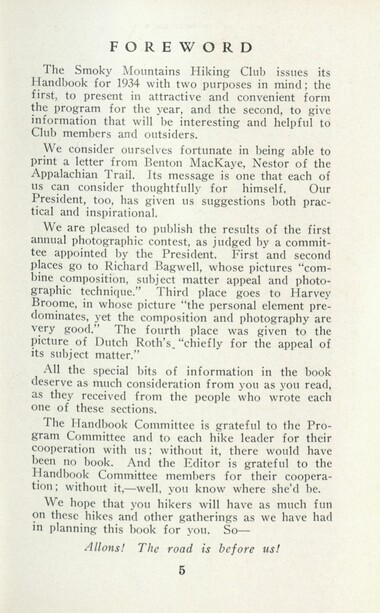
Handbook/ 1934/ Smoky Mountains Hiking Club
GSMNP_13150_54_02_1143_05
Handbook/ 1934/ Smoky Mountains Hiking Club
GSMNP_13150_54_02_1143_06
Handbook/ 1934/ Smoky Mountains Hiking Club
GSMNP_13150_54_02_1143_07
Handbook/ 1934/ Smoky Mountains Hiking Club
GSMNP_13150_54_02_1143_08
Handbook/ 1934/ Smoky Mountains Hiking Club
GSMNP_13150_54_02_1143_09
Handbook/ 1934/ Smoky Mountains Hiking Club
GSMNP_13150_54_02_1143_10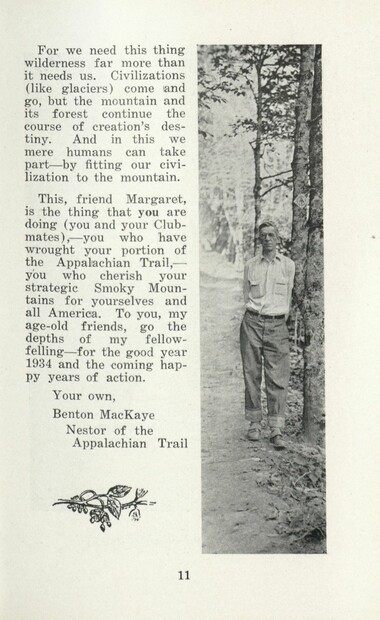
Handbook/ 1934/ Smoky Mountains Hiking Club
GSMNP_13150_54_02_1143_11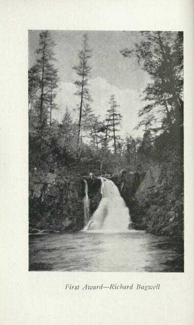
Handbook/ 1934/ Smoky Mountains Hiking Club
GSMNP_13150_54_02_1143_12
Handbook/ 1934/ Smoky Mountains Hiking Club
GSMNP_13150_54_02_1143_13
Handbook/ 1934/ Smoky Mountains Hiking Club
GSMNP_13150_54_02_1143_14
Handbook/ 1934/ Smoky Mountains Hiking Club
GSMNP_13150_54_02_1143_15
Handbook/ 1934/ Smoky Mountains Hiking Club
GSMNP_13150_54_02_1143_16
Handbook/ 1934/ Smoky Mountains Hiking Club
GSMNP_13150_54_02_1143_17
Handbook/ 1934/ Smoky Mountains Hiking Club
GSMNP_13150_54_02_1143_18
Handbook/ 1934/ Smoky Mountains Hiking Club
GSMNP_13150_54_02_1143_19
Handbook/ 1934/ Smoky Mountains Hiking Club
GSMNP_13150_54_02_1143_20
Handbook/ 1934/ Smoky Mountains Hiking Club
GSMNP_13150_54_02_1143_21
Handbook/ 1934/ Smoky Mountains Hiking Club
GSMNP_13150_54_02_1143_22
Handbook/ 1934/ Smoky Mountains Hiking Club
GSMNP_13150_54_02_1143_23
Handbook/ 1934/ Smoky Mountains Hiking Club
GSMNP_13150_54_02_1143_24
Handbook/ 1934/ Smoky Mountains Hiking Club
GSMNP_13150_54_02_1143_25
Handbook/ 1934/ Smoky Mountains Hiking Club
GSMNP_13150_54_02_1143_26
Handbook/ 1934/ Smoky Mountains Hiking Club
GSMNP_13150_54_02_1143_27
Handbook/ 1934/ Smoky Mountains Hiking Club
GSMNP_13150_54_02_1143_28
Handbook/ 1934/ Smoky Mountains Hiking Club
GSMNP_13150_54_02_1143_29
Handbook/ 1934/ Smoky Mountains Hiking Club
GSMNP_13150_54_02_1143_30
Handbook/ 1934/ Smoky Mountains Hiking Club
GSMNP_13150_54_02_1143_31
Handbook/ 1934/ Smoky Mountains Hiking Club
GSMNP_13150_54_02_1143_32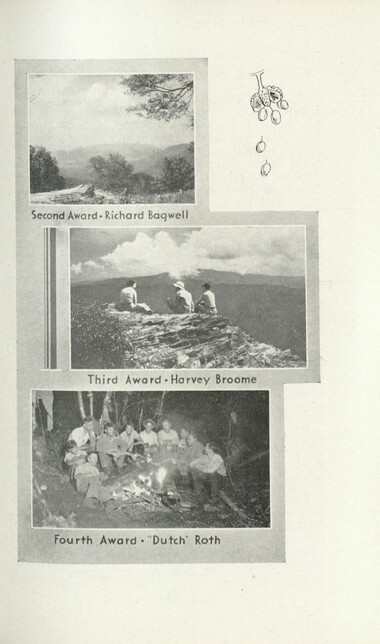
Handbook/ 1934/ Smoky Mountains Hiking Club
GSMNP_13150_54_02_1143_33
Handbook/ 1934/ Smoky Mountains Hiking Club
GSMNP_13150_54_02_1143_34
Handbook/ 1934/ Smoky Mountains Hiking Club
GSMNP_13150_54_02_1143_35
Handbook/ 1934/ Smoky Mountains Hiking Club
GSMNP_13150_54_02_1143_36
Handbook/ 1934/ Smoky Mountains Hiking Club
GSMNP_13150_54_02_1143_37
Handbook/ 1934/ Smoky Mountains Hiking Club
GSMNP_13150_54_02_1143_38
Handbook/ 1934/ Smoky Mountains Hiking Club
GSMNP_13150_54_02_1143_39
Handbook/ 1934/ Smoky Mountains Hiking Club
GSMNP_13150_54_02_1143_40
Handbook/ 1934/ Smoky Mountains Hiking Club
GSMNP_13150_54_02_1143_41
Handbook/ 1934/ Smoky Mountains Hiking Club
GSMNP_13150_54_02_1143_42
Handbook/ 1934/ Smoky Mountains Hiking Club
GSMNP_13150_54_02_1143_43
Handbook/ 1934/ Smoky Mountains Hiking Club
GSMNP_13150_54_02_1143_44
Handbook/ 1934/ Smoky Mountains Hiking Club
GSMNP_13150_54_02_1143_45
Handbook/ 1934/ Smoky Mountains Hiking Club
GSMNP_13150_54_02_1143_46
Handbook/ 1934/ Smoky Mountains Hiking Club
GSMNP_13150_54_02_1143_47
Handbook/ 1934/ Smoky Mountains Hiking Club
GSMNP_13150_54_02_1143_48
Handbook/ 1934/ Smoky Mountains Hiking Club
GSMNP_13150_54_02_1143_49
Handbook/ 1934/ Smoky Mountains Hiking Club
GSMNP_13150_54_02_1143_50
Handbook/ 1934/ Smoky Mountains Hiking Club
GSMNP_13150_54_02_1143_51
Handbook/ 1934/ Smoky Mountains Hiking Club
GSMNP_13150_54_02_1143_52
Handbook/ 1934/ Smoky Mountains Hiking Club
GSMNP_13150_54_02_1143_53
Handbook/ 1934/ Smoky Mountains Hiking Club
GSMNP_13150_54_02_1143_54
Handbook/ 1934/ Smoky Mountains Hiking Club
GSMNP_13150_54_02_1143_55
Handbook/ 1934/ Smoky Mountains Hiking Club
GSMNP_13150_54_02_1143_56
Handbook/ 1934/ Smoky Mountains Hiking Club
GSMNP_13150_54_02_1143_57
Handbook/ 1934/ Smoky Mountains Hiking Club
GSMNP_13150_54_02_1143_58
Handbook/ 1934/ Smoky Mountains Hiking Club
GSMNP_13150_54_02_1143_59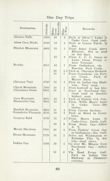
Handbook/ 1934/ Smoky Mountains Hiking Club
GSMNP_13150_54_02_1143_60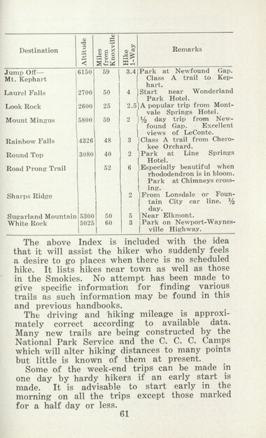
Handbook/ 1934/ Smoky Mountains Hiking Club
GSMNP_13150_54_02_1143_61
Handbook/ 1934/ Smoky Mountains Hiking Club
GSMNP_13150_54_02_1143_62
Handbook/ 1934/ Smoky Mountains Hiking Club
GSMNP_13150_54_02_1143_63
Handbook/ 1934/ Smoky Mountains Hiking Club
GSMNP_13150_54_02_1143_64
Handbook/ 1934/ Smoky Mountains Hiking Club
GSMNP_13150_54_02_1143_65
Handbook/ 1934/ Smoky Mountains Hiking Club
GSMNP_13150_54_02_1143_66Item’s are ‘child’ level descriptions to ‘parent’ objects, (e.g. one page of a whole book).
-
-
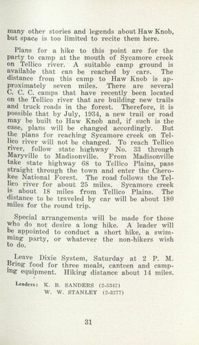
many other stories and legends about Haw Knob, but space is too limited to recite them here. Plans for a hike to this point are for the party to camp at the mouth of Sycamore creek on Tellico river. A suitable camp ground is available that can be reached by cars. The distance from this camp to Haw Knob is approximately seven miles. There are several C. C. C. camps that have recently been located on the Tellico river that are building new trails and truck roads in the forest. Therefore, it is possible that by July, 1934, a new trail or road may be built to Haw Knob and, if such is the case, plans will be changed accordingly. But the plans for reaching Sycamore creek on Tellico river will not be changed. To reach Tellico river, follow state highway No. 33 through Maryville to Madisonville. From Madisonville take state highway 68 to Tellico Plains, pass straight through the town and enter the Cherokee National Forest. The road follows the Tellico river for about 25 miles. Sycamore creek is about 18 miles from Tellico Plains. The distance to be traveled by car will be about 180 miles for the round trip. Special arrangements will be made for those who do not desire a long hike. A leader will be appointed to conduct a short hike, a swimming pa,rty, or whatever the non-hikers wish to do. Leave Dixie System, Saturday at 2 P. M. Bring food for three meals, canteen and camping equipment. Hiking distance about 14 miles. Leaders: K. B. SANDERS (2-5342) W. W. STANLEY (2-3277) 31
Object’s are ‘parent’ level descriptions to ‘children’ items, (e.g. a book with pages).
-
In 1926, the Smoky Mountains Hiking Club began to print an annual handbook that outlined scheduled hikes for each month of the year, including winter. This 1934 handbook was collected by George Masa (1881-1933), a photographer active in the Appalachian Trail Club and in the movement to establish the Great Smoky Mountains National Park. The Smoky Mountains Hiking Club was formed after a group of outdoor enthusiasts hiked up to Mount LeConte in October 1924. Enjoying the spectacular views, the group returned to establish a formal hiking club to sponsor regularly-scheduled hikes into the Great Smoky Mountains.
-
Related items
-
Program of hikes for 1930/ Smoky Mountains Hiking Club
-
Western Carolinian Volume 32 Number 35 (36)
-
Thirteenth Annual Session of the Penland School of Crafts 1942
-
Report of the Secretary of Agriculture in relation to the forests, rivers, and mountains of the southern Appalachian region

-
The Canton Enterprise Volume 13 Number 04
-
Western Carolinian Volume 61 Number 10 (12)

-
Western Carolinian Volume 14 Number 12
-
Eleventh Annual Session of the Penland School of Handicrafts 1940 - page 5

-
Report of the Secretary of Agriculture in relation to the forests, rivers, and mountains of the southern Appalachian region

-
Western Carolinian Volume 64 (65) Number 04
-
Western Carolinian Volume 52 Number 11 (02)

-
Western Carolinian Volume 43 Number 16
-
Western Carolinian Volume 35 Number 13

-
Western Carolinian Volume 34 Number 36

-
Western Carolinian Volume 67 Number 08
-
Western Carolinian Volume 57 Number 22

-
Western Carolinian Volume 60 Number 09

-
Western Carolinian Volume 42 Number 65

-
Western Carolinia Volume 47 Number 09
-
Western Carolinian Volume 49 Number 12
-
Western Carolinian Volume 46 Number 19

-
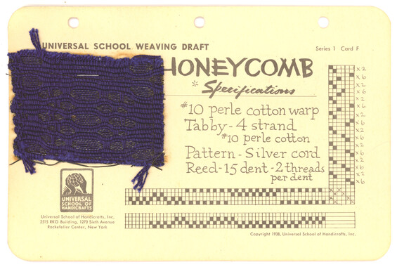
Universal School Weaving Draft: Honeycomb
-
Western Carolinian Volume 56 Number 21

-
Great Smoky Mountains
-
Western Carolinian Volume 46 Number 16

-
Report of the Secretary of Agriculture in relation to the forests, rivers, and mountains of the southern Appalachian region
-
Western Carolinian Volume 41 Number 10
-
Cherokee Indian Fair 1948
-
Western Carolinian Volume 64 (65) Number 07

-
Western Carolinian Volume 65 (66) Number 18
-
Study for the Preservation of Mountain Culture in Field Museum of History

-
Western Carolinian Volume 60 Number 09

Part of Collection
Great Smoky Mountains - A Park for America
-
Civilian Conservation Corps Annual: District "C"

-
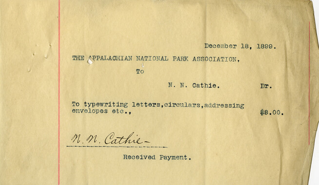
Financial receipts and expenditures, 1899

-
Senate 5518 report

-
Appalachian National Park Association Newspaper Clippings, 1902-1907, 1925, 1928
-
Cataloochee tract 231: W. G. B. Messer
-
Cataloochee tract 217: Cataloochee School

-
Report of the Secretary of Agriculture in relation to the forests, rivers, and mountains of the southern Appalachian region

-
Financial receipts and expenditures, 1902

-
Resolution presented to Alabama
-
How to Reach our New National Park in the Great Smoky Mountains
-
Financial receipts and expenditures, 1902

-
CCC enrollees
-
Report of the Secretary of Agriculture in relation to the forests, rivers, and mountains of the southern Appalachian region

-
Correspondence between Zebulon Weaver, Fred L. Weede, W. H. Woodbury, David C. Chapman, Mark Squires, Junius G. Adams, March 1932

-
Senate 5518 report
-
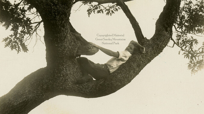
Hiker
-
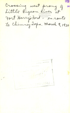
Crossing the west prong of Little Pigeon River
-
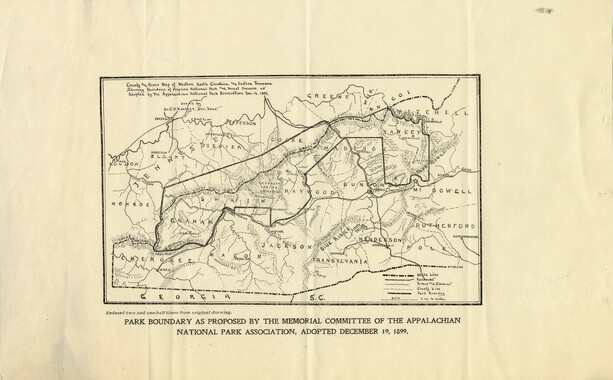
Proposed Appalachian Forest Reserve

-
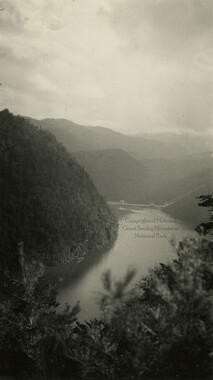
Calderwood Lake and Dam
-
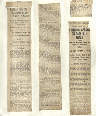
Appalachian National Park Association Newspaper Clippings, 1899-1902
-
Hardwood Bark, 1929

-
Clingmans Dome from Mount LeConte
-
Planning in the Smokies
-
Great Smoky Mountains National Park, North Carolina - Tennessee

-
Study for the Preservation of Mountain Culture in Field Museum of History

-
Memorial to the Congress of the United States
-
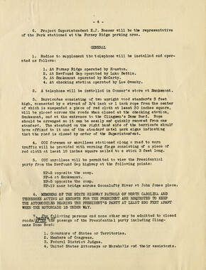
Park dedication: traffic control
-
Appalachian National Park Association Newspaper Clippings, 1899-1902
-
Great Smoky Mountains National Park / Land of the Everlasting Hills
-
Congressional speech for forest reserve
-
Financial receipts and expenditures, 1900

-
Financial receipts and expenditures, 1899