- Canton Champion Fibre Company (2308)
- Cherokee Traditions (292)
- Civil War in Southern Appalachia (165)
- Craft Revival (1942)
- Great Smoky Mountains - A Park for America (2766)
- Highlights from Western Carolina University (430)
- Horace Kephart (941)
- Journeys Through Jackson (154)
- LGBTQIA+ Archive of Jackson County (85)
- Oral Histories of Western North Carolina (314)
- Picturing Appalachia (6772)
- Stories of Mountain Folk (413)
- Travel Western North Carolina (160)
- Western Carolina University Fine Art Museum Vitreograph Collection (129)
- Western Carolina University Herbarium (92)
- Western Carolina University: Making Memories (708)
- Western Carolina University Publications (2283)
- Western Carolina University Restricted Electronic Theses and Dissertations (146)
- Western North Carolina Regional Maps (71)
- World War II in Southern Appalachia (131)
- Allanstand Cottage Industries (62)
- Appalachian National Park Association (53)
- Bennett, Kelly, 1890-1974 (1388)
- Berry, Walter (76)
- Brasstown Carvers (40)
- Carver, George Washington, 1864?-1943 (26)
- Cathey, Joseph, 1803-1874 (1)
- Champion Fibre Company (233)
- Champion Paper and Fibre Company (297)
- Cherokee Indian Fair Association (16)
- Cherokee Language Program (22)
- Crowe, Amanda (40)
- Edmonston, Thomas Benton, 1842-1907 (7)
- Ensley, A. L. (Abraham Lincoln), 1865-1948 (275)
- Fromer, Irving Rhodes, 1913-1994 (70)
- George Butz (BFS 1907) (46)
- Goodrich, Frances Louisa (120)
- Grant, George Alexander, 1891-1964 (96)
- Heard, Marian Gladys (60)
- Kephart, Calvin, 1883-1969 (15)
- Kephart, Horace, 1862-1931 (313)
- Kephart, Laura, 1862-1954 (39)
- Laney, Gideon Thomas, 1889-1976 (439)
- Masa, George, 1881-1933 (61)
- McElhinney, William Julian, 1896-1953 (44)
- Niggli, Josephina, 1910-1983 (10)
- North Carolina Park Commission (105)
- Osborne, Kezia Stradley (9)
- Owens, Samuel Robert, 1918-1995 (11)
- Penland Weavers and Potters (36)
- Roberts, Vivienne (15)
- Roth, Albert, 1890-1974 (142)
- Schenck, Carl Alwin, 1868-1955 (1)
- Sherrill's Photography Studio (2565)
- Southern Highland Handicraft Guild (127)
- Southern Highlanders, Inc. (71)
- Stalcup, Jesse Bryson (46)
- Stearns, I. K. (213)
- Thompson, James Edward, 1880-1976 (226)
- United States. Indian Arts and Crafts Board (130)
- USFS (683)
- Vance, Zebulon Baird, 1830-1894 (1)
- Weaver, Zebulon, 1872-1948 (58)
- Western Carolina College (230)
- Western Carolina Teachers College (282)
- Western Carolina University (1794)
- Western Carolina University. Mountain Heritage Center (18)
- Whitman, Walt, 1819-1892 (10)
- Wilburn, Hiram Coleman, 1880-1967 (73)
- Williams, Isadora (3)
- Cain, Doreyl Ammons (0)
- Crittenden, Lorraine (0)
- Rhodes, Judy (0)
- Smith, Edward Clark (0)
- Appalachian Region, Southern (2569)
- Asheville (N.C.) (1923)
- Avery County (N.C.) (26)
- Blount County (Tenn.) (161)
- Buncombe County (N.C.) (1672)
- Cherokee County (N.C.) (283)
- Clay County (N.C.) (555)
- Graham County (N.C.) (233)
- Great Smoky Mountains National Park (N.C. and Tenn.) (519)
- Haywood County (N.C.) (3524)
- Henderson County (N.C.) (70)
- Jackson County (N.C.) (4694)
- Knox County (Tenn.) (25)
- Knoxville (Tenn.) (12)
- Lake Santeetlah (N.C.) (10)
- Macon County (N.C.) (420)
- Madison County (N.C.) (212)
- McDowell County (N.C.) (39)
- Mitchell County (N.C.) (132)
- Polk County (N.C.) (35)
- Qualla Boundary (981)
- Rutherford County (N.C.) (76)
- Swain County (N.C.) (2115)
- Transylvania County (N.C.) (270)
- Watauga County (N.C.) (12)
- Waynesville (N.C.) (84)
- Yancey County (N.C.) (72)
- Aerial Photographs (3)
- Aerial Views (60)
- Albums (books) (4)
- Articles (1)
- Artifacts (object Genre) (228)
- Bibliographies (1)
- Biography (general Genre) (2)
- Cards (information Artifacts) (38)
- Clippings (information Artifacts) (191)
- Crafts (art Genres) (622)
- Depictions (visual Works) (21)
- Design Drawings (1)
- Drawings (visual Works) (184)
- Envelopes (73)
- Facsimiles (reproductions) (1)
- Fiction (general Genre) (4)
- Financial Records (12)
- Fliers (printed Matter) (67)
- Glass Plate Negatives (381)
- Guidebooks (2)
- Internegatives (10)
- Interviews (815)
- Land Surveys (102)
- Letters (correspondence) (1013)
- Manuscripts (documents) (618)
- Maps (documents) (177)
- Memorandums (25)
- Minutes (administrative Records) (59)
- Negatives (photographs) (5835)
- Newsletters (1285)
- Newspapers (2)
- Occupation Currency (1)
- Paintings (visual Works) (1)
- Pen And Ink Drawings (1)
- Periodicals (193)
- Personal Narratives (10)
- Photographs (12976)
- Plans (maps) (1)
- Poetry (6)
- Portraits (4533)
- Postcards (329)
- Programs (documents) (151)
- Publications (documents) (2236)
- Questionnaires (65)
- Scrapbooks (282)
- Sheet Music (2)
- Slides (photographs) (402)
- Songs (musical Compositions) (2)
- Sound Recordings (796)
- Specimens (92)
- Speeches (documents) (15)
- Tintypes (photographs) (8)
- Transcripts (322)
- Video Recordings (physical Artifacts) (23)
- Vitreographs (129)
- Text Messages (0)
- A.L. Ensley Collection (275)
- Appalachian Industrial School Records (7)
- Appalachian National Park Association Records (336)
- Axley-Meroney Collection (2)
- Bayard Wootten Photograph Collection (20)
- Bethel Rural Community Organization Collection (7)
- Blumer Collection (5)
- C.W. Slagle Collection (20)
- Canton Area Historical Museum (2110)
- Carlos C. Campbell Collection (282)
- Cataloochee History Project (64)
- Cherokee Studies Collection (4)
- Daisy Dame Photograph Album (5)
- Daniel Boone VI Collection (1)
- Doris Ulmann Photograph Collection (112)
- Elizabeth H. Lasley Collection (1)
- Elizabeth Woolworth Szold Fleharty Collection (4)
- Frank Fry Collection (95)
- George Masa Collection (173)
- Gideon Laney Collection (452)
- Hazel Scarborough Collection (2)
- Hiram C. Wilburn Papers (28)
- Historic Photographs Collection (236)
- Horace Kephart Collection (861)
- Humbard Collection (33)
- Hunter and Weaver Families Collection (1)
- I. D. Blumenthal Collection (4)
- Isadora Williams Collection (4)
- Jesse Bryson Stalcup Collection (47)
- Jim Thompson Collection (224)
- John B. Battle Collection (7)
- John C. Campbell Folk School Records (80)
- John Parris Collection (6)
- Judaculla Rock project (2)
- Kelly Bennett Collection (1407)
- Love Family Papers (11)
- Major Wiley Parris Civil War Letters (3)
- Map Collection (12)
- McFee-Misemer Civil War Letters (34)
- Mountain Heritage Center Collection (4)
- Norburn - Robertson - Thomson Families Collection (44)
- Pauline Hood Collection (7)
- Pre-Guild Collection (2)
- Qualla Arts and Crafts Mutual Collection (12)
- R.A. Romanes Collection (681)
- Rosser H. Taylor Collection (1)
- Samuel Robert Owens Collection (94)
- Sara Madison Collection (144)
- Sherrill Studio Photo Collection (2558)
- Smoky Mountains Hiking Club Collection (616)
- Stories of Mountain Folk - Radio Programs (374)
- The Reporter, Western Carolina University (510)
- Venoy and Elizabeth Reed Collection (16)
- WCU Gender and Sexuality Oral History Project (32)
- WCU Mountain Heritage Center Oral Histories (25)
- WCU Oral History Collection - Mountain People, Mountain Lives (71)
- WCU Students Newspapers Collection (1744)
- Western North Carolina Tomorrow Black Oral History Project (69)
- William Williams Stringfield Collection (2)
- Zebulon Weaver Collection (109)
- African Americans (390)
- Appalachian Trail (35)
- Artisans (521)
- Cherokee art (84)
- Cherokee artists -- North Carolina (10)
- Cherokee language (21)
- Cherokee pottery (101)
- Cherokee women (208)
- Church buildings (170)
- Civilian Conservation Corps (U.S.) (110)
- College student newspapers and periodicals (1830)
- Dams (107)
- Dance (1023)
- Education (222)
- Floods (61)
- Folk music (1015)
- Forced removal, 1813-1903 (2)
- Forest conservation (220)
- Forests and forestry (1184)
- Gender nonconformity (4)
- Great Smoky Mountains National Park (N.C. and Tenn.) (181)
- Hunting (38)
- Landscape photography (25)
- Logging (118)
- Maps (83)
- Mines and mineral resources (8)
- North Carolina -- Maps (18)
- Paper industry (38)
- Postcards (255)
- Pottery (135)
- Railroad trains (71)
- Rural electrification -- North Carolina, Western (3)
- School integration -- Southern States (2)
- Segregation -- North Carolina, Western (5)
- Slavery (5)
- Sports (452)
- Storytelling (244)
- Waterfalls -- Great Smoky Mountains (N.C. and Tenn.) (66)
- Weaving -- Appalachian Region, Southern (280)
- Wood-carving -- Appalachian Region, Southern (328)
- World War, 1939-1945 (173)
Federal court records: Latimer v. Poteet, Meigs Post
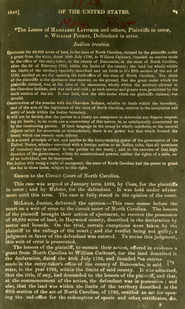
Federal court records: Latimer v. Poteet, Meigs Post
GSMNP_13150_15_1128_01
Federal court records: Latimer v. Poteet, Meigs Post
GSMNP_13150_15_1128_02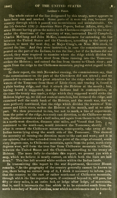
Federal court records: Latimer v. Poteet, Meigs Post
GSMNP_13150_15_1128_03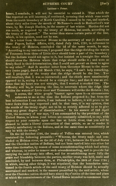
Federal court records: Latimer v. Poteet, Meigs Post
GSMNP_13150_15_1128_04
Federal court records: Latimer v. Poteet, Meigs Post
GSMNP_13150_15_1128_05
Federal court records: Latimer v. Poteet, Meigs Post
GSMNP_13150_15_1128_06
Federal court records: Latimer v. Poteet, Meigs Post
GSMNP_13150_15_1128_07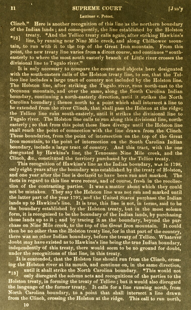
Federal court records: Latimer v. Poteet, Meigs Post
GSMNP_13150_15_1128_08
Federal court records: Latimer v. Poteet, Meigs Post
GSMNP_13150_15_1128_09
Federal court records: Latimer v. Poteet, Meigs Post
GSMNP_13150_15_1128_10
Federal court records: Latimer v. Poteet, Meigs Post
GSMNP_13150_15_1128_11
Federal court records: Latimer v. Poteet, Meigs Post
GSMNP_13150_15_1128_12
Federal court records: Latimer v. Poteet, Meigs Post
GSMNP_13150_15_1128_13Item’s are ‘child’ level descriptions to ‘parent’ objects, (e.g. one page of a whole book).
-
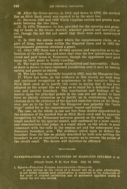
-
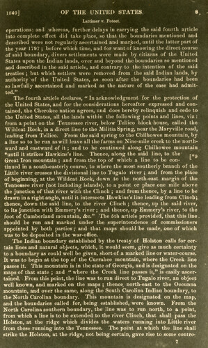
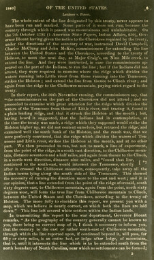
- OF THE UNITED STATES. Lattimcr v. Poteet. operations: and whereas, further delays in carrying the said fourth article into complete effect did take place, so that the boundaries mentioned and described were not regularly ascertained and marked, until the latter part of the year 1797 ; before which time, and for want of knowing the direct course of said boundary, divers settlements were made by citizens of the United States upon the Indian lands, over and beyond the boundaries so mentioned and described in the said article, and contrary to the intention of the said treaties ; but which settlers were removed from the said Indian lands, by authority of the United States, as soon after the boundaries had been so lawfully ascertained and marked as the nature of the case had admitted." The fourth article declares, " In acknowledgment for the protection of the United States, and for the considerations hereafter expressed and contained, the Cherokee nation agrees, end does hereby relinquish and cede to the United States, all the lands within the following points and lines, viz : from a point on the Tennessee river, below Tellico block house, called the "Wildcat Rock, in a direct line to the Militia Spring, near the Maryville road, leading from Tellico. From the said spring to the Chilhowee mountain, by a line so to be run as will leave all the farms on Nine-mile creek to the northward and eastward of it; and to be continued along Chilhowee mountain ♦until it strikes Hawkins's line. Thence, along the said line, to the r*9 Great Iron mountain ; and from the top of which a line to be con- "- tinued in a south-easterly course, to where the most southerly branch of the Little river crosses the divisional line to Tugalo river ; and from the place of beginning, at the Wildcat Rock, down to the north-east margin of the Tennessee river (not including islands), to a point or place one mile above the junction of that river with the Clinch ; and from thence, by a line to be drawn in a right angle, until it intersects Hawkins's line leading from Clinch; thence, down the said line, to the river Clinch ; thence, up the said river, to its junction with Emmery's river ; and thence, up Emmery's river, to the foot of Cumberland mountain, &c." The 5th article provided, that this line . should be run and marked under the superintendence of commissioners appointed by both parties r and that maps should be made, one of which was to be deposited in the war-office. The Indian boundary established by the treaty of Holston calls for certain lines and natural objects, which, it would seem, give as much certainty to a boundary as could well be given, short of a marked line or water-course. It was to begin at the top of the Currahee mountain, where the Creek line passes it. This mountain is in the state of Georgia, and is designated on the maps of that state ; and " where the Creek line passes it," is easily ascertained. From this point, the line was to run direct to Tugalo river, an object well known, and marked on the maps ; thence, north-east to the Occunna mountain, and over the same, along the South Carolina Indian boundary, to the North Carolina boundary. This mountain is designated on the map, and the boundaries called for, being established, were known. From the North Carolina southern boundary, the line was to run north, to a point, from which a line is to be extended to the river Clinch, that shall pass the Holston, at the ridge which divides the waters running into Little river from those running into the Tennessee. The point at which the line shall strike the Holston, at the ridge, not being certain, gave rise to some contro-
Object’s are ‘parent’ level descriptions to ‘children’ items, (e.g. a book with pages).
-
These copies of federal court records were collected by photographer, George Masa. Born Masahara Iizuka and raised in Japan, photographer George Masa (1881-1933) was active in the Appalachian Trail Club and in the movement to establish the Great Smoky Mountains National Park. In 1931, Masa was named to the three-person nomenclature committee for the North Carolina Park Commission and had the responsibility for accurately naming the peaks, streams, and other features. No doubt, these records pertain to the Smokies region and the disposition of land that would eventually become the Great Smoky Mountains National Park.
-
Related items
-
Davy Arch: Cherokee Artist and Mask Maker

-
Senate 5518 report
-
Oral history of logging: Jack Swanner remembers Tommy Thompson

-
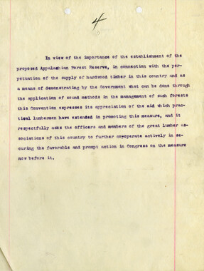
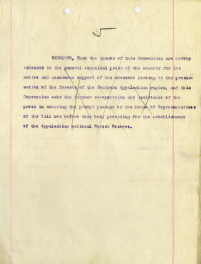
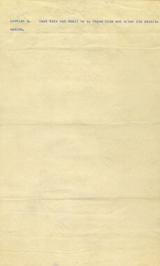
Convention resolutions

-
Senate Bill 5518
-
Senate Bill 5518
-
Convention resolutions

-
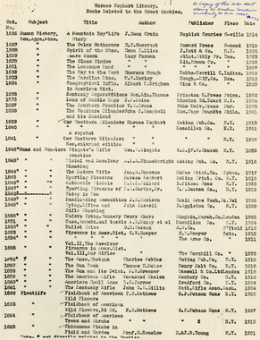
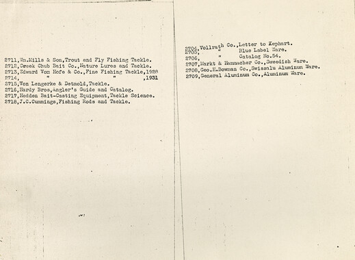
Kephart library: books related to the Great Smokies
-
Senate 5518 report

-
Senate 5518 report

-
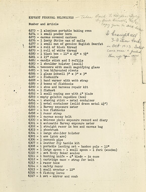
Kephart personal belongings inventory
-
Federal court records: Stevenson et al. v. Fain et al.: Telico River area

-
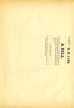
H.R. 1196
-
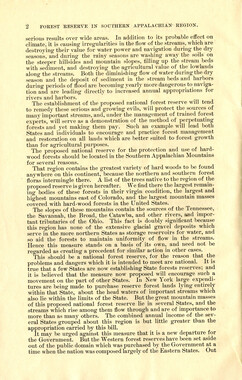
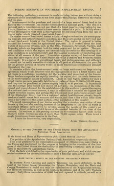
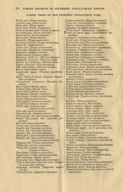
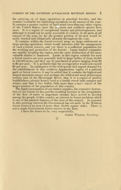
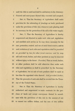
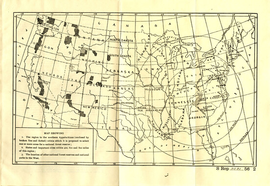
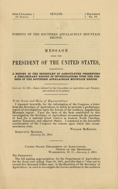
Report of Investigations upon the Forests of the Southern Appalachian Mountain Region
-
Resolution presented to U.S. Congress

-
Senate Bill 5228
-
Convention resolutions
-
Kephart personal belongings inventory
-
Kephart personal belongings inventory
-
Senate Bill 5228

-
Federal court records: Latimer v. Poteet, Meigs Post
-
Senate Act 5228

-
Federal court records, Belding et al. v. Hebard: Slick Rock Creek area
-
Federal court records, Belding et al. v. Hebard: Slick Rock Creek area

-
Kephart library: books related to the Great Smokies
-
Senate 5518 report
-
Federal court records, Belding et al. v. Hebard: Slick Rock Creek area

-
Tom Belt: Cherokee Language Teacher
-
Convention resolutions
-
Convention resolutions

-
Legislative act to give consent by South Carolina
-
Report of Investigations upon the Forests of the Southern Appalachian Mountain Region
Part of Collection
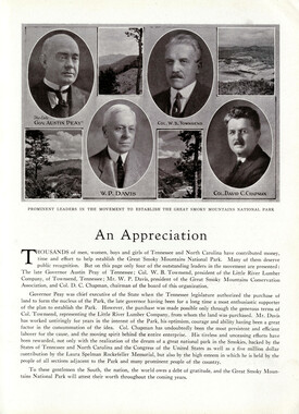
Great Smoky Mountains - A Park for America
-
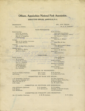
Legislation Secured by the Appalachian National Park Association
-
Phacelia Buds

-
Nature Magazine: Carolina number
-
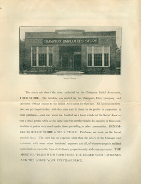
Champion Relief Association
-
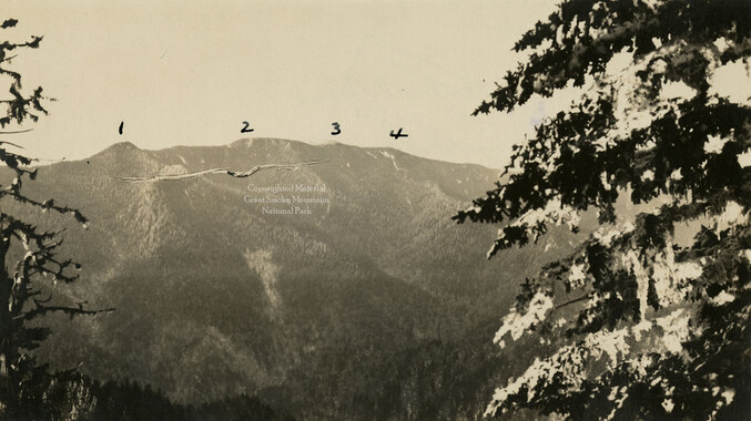
Mount LeConte from Chimney Tops
-
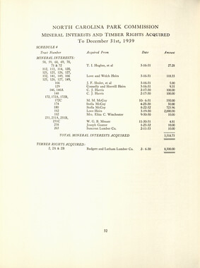
Complete Report Submitted to Governor Clyde R. Hoey
-
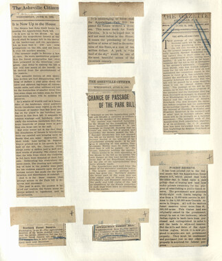
Appalachian National Park Association Newspaper Clippings, 1899-1902
-
Great Smoky Mountains National Park / Land of the Everlasting Hills
-
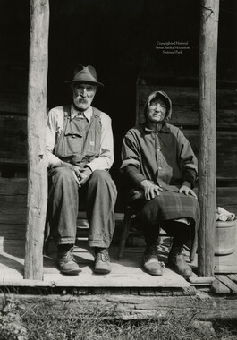
James Hannah and Mellissee Hannah
-
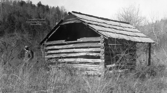
Cataloochee: fields

-
Rifles: fitting a rifle stock

-
Photo Album of the Great Smokey Mountains

-
Complete Report Submitted to Governor Clyde R. Hoey

-
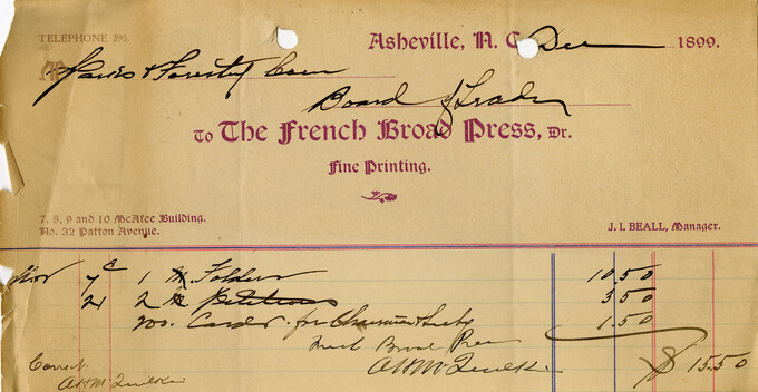
Financial receipts and expenditures, 1899
-
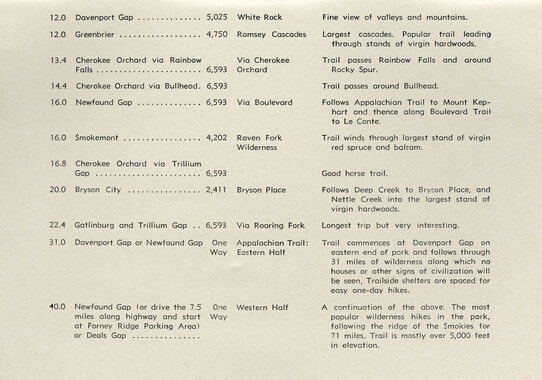
Great Smoky National Park:Travel Index
-
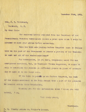
Correspondence regarding 1901 meeting

-
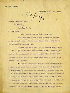
Correspondence: M. V. Richards to A. H. McQuilkin

-
Minutes of Meetings of the Appalachian National Park Association

-
Letters supporting Appalachian National Park movement
-
Appalachian National Park: Synopsis of work accomplished
-
Foundation of Quality: Organization/ Equipment/ Service

-
Program of hikes for 1930/ Smoky Mountains Hiking Club
-
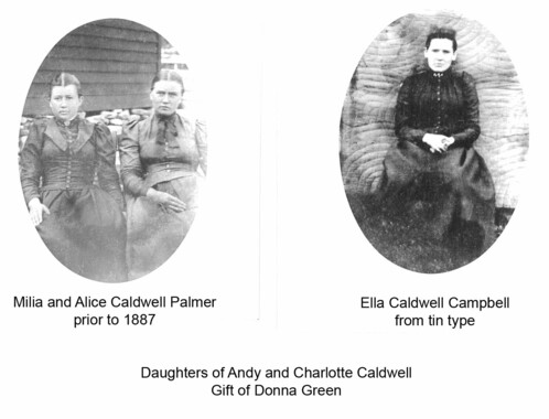
Cataloochee tract 213: Charles Ray Caldwell
-
Cataloochee tract 201: J. L. Caldwell
-
Financial receipts and expenditures, 1902

-
Legislation on behalf of the Appalachian National Park
-
Requests for information on Appalachian National Park
-
Just the High Spots of Knoxville and East Tennessee

-
Oral history of logging: Dickie Woodard remembers Charles Woodard

-
Financial receipts and expenditures, 1900

-
Mount LeConte and Clingmans Dome

-
Guide to the Great Smoky Mountains National Park
