- Great Smoky Mountains - A Park for America (24)
- Canton Champion Fibre Company (0)
- Cherokee Traditions (0)
- Civil War in Southern Appalachia (0)
- Craft Revival (0)
- Highlights from Western Carolina University (0)
- Horace Kephart (0)
- Journeys Through Jackson (0)
- LGBTQIA+ Archive of Jackson County (0)
- Oral Histories of Western North Carolina (0)
- Picturing Appalachia (0)
- Stories of Mountain Folk (0)
- Travel Western North Carolina (0)
- Western Carolina University Fine Art Museum Vitreograph Collection (0)
- Western Carolina University Herbarium (0)
- Western Carolina University: Making Memories (0)
- Western Carolina University Publications (0)
- Western Carolina University Restricted Electronic Theses and Dissertations (0)
- Western North Carolina Regional Maps (0)
- World War II in Southern Appalachia (0)
- Faces of Asheville (0)
- Forestry in Western North Carolina (0)
- Grove Park Inn Photograph Collection (0)
- Isaiah Rice Photograph Collection (0)
- Morse Family Chimney Rock Park Collection (0)
- Picturing Asheville and Western North Carolina (0)
- Allanstand Cottage Industries (62)
- Appalachian National Park Association (53)
- Bennett, Kelly, 1890-1974 (1388)
- Berry, Walter (76)
- Brasstown Carvers (40)
- Carver, George Washington, 1864?-1943 (26)
- Cathey, Joseph, 1803-1874 (1)
- Champion Fibre Company (233)
- Champion Paper and Fibre Company (297)
- Cherokee Indian Fair Association (16)
- Cherokee Language Program (22)
- Crowe, Amanda (40)
- Edmonston, Thomas Benton, 1842-1907 (7)
- Ensley, A. L. (Abraham Lincoln), 1865-1948 (275)
- Fromer, Irving Rhodes, 1913-1994 (70)
- George Butz (BFS 1907) (46)
- Goodrich, Frances Louisa (120)
- Grant, George Alexander, 1891-1964 (96)
- Heard, Marian Gladys (60)
- Kephart, Calvin, 1883-1969 (15)
- Kephart, Horace, 1862-1931 (313)
- Kephart, Laura, 1862-1954 (39)
- Laney, Gideon Thomas, 1889-1976 (439)
- Masa, George, 1881-1933 (61)
- McElhinney, William Julian, 1896-1953 (44)
- Niggli, Josephina, 1910-1983 (10)
- North Carolina Park Commission (105)
- Osborne, Kezia Stradley (9)
- Owens, Samuel Robert, 1918-1995 (11)
- Penland Weavers and Potters (36)
- Roberts, Vivienne (15)
- Roth, Albert, 1890-1974 (142)
- Schenck, Carl Alwin, 1868-1955 (1)
- Sherrill's Photography Studio (2565)
- Southern Highland Handicraft Guild (127)
- Southern Highlanders, Inc. (71)
- Stalcup, Jesse Bryson (46)
- Stearns, I. K. (213)
- Thompson, James Edward, 1880-1976 (226)
- United States. Indian Arts and Crafts Board (130)
- USFS (683)
- Vance, Zebulon Baird, 1830-1894 (1)
- Weaver, Zebulon, 1872-1948 (58)
- Western Carolina College (230)
- Western Carolina Teachers College (282)
- Western Carolina University (1794)
- Western Carolina University. Mountain Heritage Center (18)
- Whitman, Walt, 1819-1892 (10)
- Wilburn, Hiram Coleman, 1880-1967 (73)
- Williams, Isadora (3)
- Cain, Doreyl Ammons (0)
- Crittenden, Lorraine (0)
- Rhodes, Judy (0)
- Smith, Edward Clark (0)
- 1850s (1)
- 1860s (1)
- 1870s (3)
- 1880s (2)
- 1900s (2)
- 1910s (4)
- 1920s (23)
- 1930s (20)
- 1940s (10)
- 1950s (4)
- 1970s (4)
- 1980s (3)
- 1990s (3)
- 2000s (21)
- 1600s (0)
- 1700s (0)
- 1800s (0)
- 1810s (0)
- 1820s (0)
- 1830s (0)
- 1840s (0)
- 1890s (0)
- 1960s (0)
- 2010s (0)
- 2020s (0)
- Great Smoky Mountains National Park (N.C. and Tenn.) (1)
- Haywood County (N.C.) (24)
- Appalachian Region, Southern (0)
- Asheville (N.C.) (0)
- Avery County (N.C.) (0)
- Blount County (Tenn.) (0)
- Buncombe County (N.C.) (0)
- Cherokee County (N.C.) (0)
- Clay County (N.C.) (0)
- Graham County (N.C.) (0)
- Henderson County (N.C.) (0)
- Jackson County (N.C.) (0)
- Knox County (Tenn.) (0)
- Knoxville (Tenn.) (0)
- Lake Santeetlah (N.C.) (0)
- Macon County (N.C.) (0)
- Madison County (N.C.) (0)
- McDowell County (N.C.) (0)
- Mitchell County (N.C.) (0)
- Polk County (N.C.) (0)
- Qualla Boundary (0)
- Rutherford County (N.C.) (0)
- Swain County (N.C.) (0)
- Transylvania County (N.C.) (0)
- Watauga County (N.C.) (0)
- Waynesville (N.C.) (0)
- Yancey County (N.C.) (0)
- Clippings (information Artifacts) (7)
- Land Surveys (22)
- Letters (correspondence) (3)
- Manuscripts (documents) (8)
- Maps (documents) (9)
- Photographs (19)
- Portraits (8)
- Publications (documents) (23)
- Aerial Photographs (0)
- Aerial Views (0)
- Albums (books) (0)
- Articles (0)
- Artifacts (object Genre) (0)
- Bibliographies (0)
- Biography (general Genre) (0)
- Cards (information Artifacts) (0)
- Crafts (art Genres) (0)
- Depictions (visual Works) (0)
- Design Drawings (0)
- Drawings (visual Works) (0)
- Envelopes (0)
- Facsimiles (reproductions) (0)
- Fiction (general Genre) (0)
- Financial Records (0)
- Fliers (printed Matter) (0)
- Glass Plate Negatives (0)
- Guidebooks (0)
- Internegatives (0)
- Interviews (0)
- Memorandums (0)
- Minutes (administrative Records) (0)
- Negatives (photographs) (0)
- Newsletters (0)
- Newspapers (0)
- Occupation Currency (0)
- Paintings (visual Works) (0)
- Pen And Ink Drawings (0)
- Periodicals (0)
- Personal Narratives (0)
- Plans (maps) (0)
- Poetry (0)
- Postcards (0)
- Programs (documents) (0)
- Questionnaires (0)
- Scrapbooks (0)
- Sheet Music (0)
- Slides (photographs) (0)
- Songs (musical Compositions) (0)
- Sound Recordings (0)
- Specimens (0)
- Speeches (documents) (0)
- Text Messages (0)
- Tintypes (photographs) (0)
- Transcripts (0)
- Video Recordings (physical Artifacts) (0)
- Vitreographs (0)
- Cataloochee History Project (2)
- A.L. Ensley Collection (0)
- Appalachian Industrial School Records (0)
- Appalachian National Park Association Records (0)
- Axley-Meroney Collection (0)
- Bayard Wootten Photograph Collection (0)
- Bethel Rural Community Organization Collection (0)
- Blumer Collection (0)
- C.W. Slagle Collection (0)
- Canton Area Historical Museum (0)
- Carlos C. Campbell Collection (0)
- Cherokee Studies Collection (0)
- Daisy Dame Photograph Album (0)
- Daniel Boone VI Collection (0)
- Doris Ulmann Photograph Collection (0)
- Elizabeth H. Lasley Collection (0)
- Elizabeth Woolworth Szold Fleharty Collection (0)
- Frank Fry Collection (0)
- George Masa Collection (0)
- Gideon Laney Collection (0)
- Hazel Scarborough Collection (0)
- Hiram C. Wilburn Papers (0)
- Historic Photographs Collection (0)
- Horace Kephart Collection (0)
- Humbard Collection (0)
- Hunter and Weaver Families Collection (0)
- I. D. Blumenthal Collection (0)
- Isadora Williams Collection (0)
- Jesse Bryson Stalcup Collection (0)
- Jim Thompson Collection (0)
- John B. Battle Collection (0)
- John C. Campbell Folk School Records (0)
- John Parris Collection (0)
- Judaculla Rock project (0)
- Kelly Bennett Collection (0)
- Love Family Papers (0)
- Major Wiley Parris Civil War Letters (0)
- Map Collection (0)
- McFee-Misemer Civil War Letters (0)
- Mountain Heritage Center Collection (0)
- Norburn - Robertson - Thomson Families Collection (0)
- Pauline Hood Collection (0)
- Pre-Guild Collection (0)
- Qualla Arts and Crafts Mutual Collection (0)
- R.A. Romanes Collection (0)
- Rosser H. Taylor Collection (0)
- Samuel Robert Owens Collection (0)
- Sara Madison Collection (0)
- Sherrill Studio Photo Collection (0)
- Smoky Mountains Hiking Club Collection (0)
- Stories of Mountain Folk - Radio Programs (0)
- The Reporter, Western Carolina University (0)
- Venoy and Elizabeth Reed Collection (0)
- WCU Gender and Sexuality Oral History Project (0)
- WCU Mountain Heritage Center Oral Histories (0)
- WCU Oral History Collection - Mountain People, Mountain Lives (0)
- WCU Students Newspapers Collection (0)
- Western North Carolina Tomorrow Black Oral History Project (0)
- William Williams Stringfield Collection (0)
- Zebulon Weaver Collection (0)
- Church buildings (2)
- Maps (5)
- African Americans (0)
- Appalachian Trail (0)
- Artisans (0)
- Cherokee art (0)
- Cherokee artists -- North Carolina (0)
- Cherokee language (0)
- Cherokee pottery (0)
- Cherokee women (0)
- Civilian Conservation Corps (U.S.) (0)
- College student newspapers and periodicals (0)
- Dams (0)
- Dance (0)
- Education (0)
- Floods (0)
- Folk music (0)
- Forced removal, 1813-1903 (0)
- Forest conservation (0)
- Forests and forestry (0)
- Gender nonconformity (0)
- Great Smoky Mountains National Park (N.C. and Tenn.) (0)
- Hunting (0)
- Landscape photography (0)
- Logging (0)
- Mines and mineral resources (0)
- North Carolina -- Maps (0)
- Paper industry (0)
- Postcards (0)
- Pottery (0)
- Railroad trains (0)
- Rural electrification -- North Carolina, Western (0)
- School integration -- Southern States (0)
- Segregation -- North Carolina, Western (0)
- Slavery (0)
- Sports (0)
- Storytelling (0)
- Waterfalls -- Great Smoky Mountains (N.C. and Tenn.) (0)
- Weaving -- Appalachian Region, Southern (0)
- Wood-carving -- Appalachian Region, Southern (0)
- World War, 1939-1945 (0)
- StillImage (19)
- Text (24)
- MovingImage (0)
- Sound (0)
Cataloochee tract 218: Palmer's Chapel Church

Cataloochee tract 218: Palmer's Chapel Church
GSMNP_Cata-218
Cataloochee tract 218: Palmer's Chapel Church
GSMNP_80235
Cataloochee tract 218: Palmer's Chapel Church
GSMNP_80235_01-02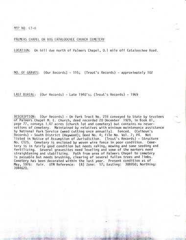
Cataloochee tract 218: Palmer's Chapel Church
GSMNP_Cata-218_CT-8
Cataloochee tract 218: Palmer's Chapel Church
GSMNP_Cata-218_699
Cataloochee tract 218: Palmer's Chapel Church
GSMNP_02120_II-B-(6)-8051_a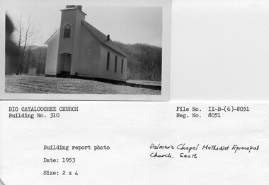
Cataloochee tract 218: Palmer's Chapel Church
GSMNP_02120_II-B-(6)-8051_b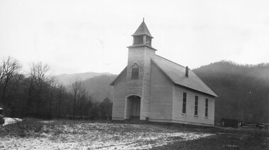
Cataloochee tract 218: Palmer's Chapel Church
GSMNP_02120_II-B-(6)-8053_a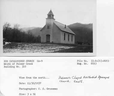
Cataloochee tract 218: Palmer's Chapel Church
GSMNP_02120_II-B-(6)-8053_b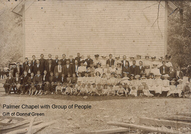
Cataloochee tract 218: Palmer's Chapel Church
GSMNP_Cata-213_Green_05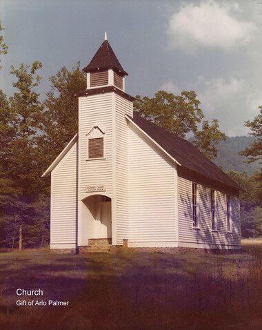
Cataloochee tract 218: Palmer's Chapel Church
GSMNP_Cata-213_Palmer_02Item’s are ‘child’ level descriptions to ‘parent’ objects, (e.g. one page of a whole book).
-
-
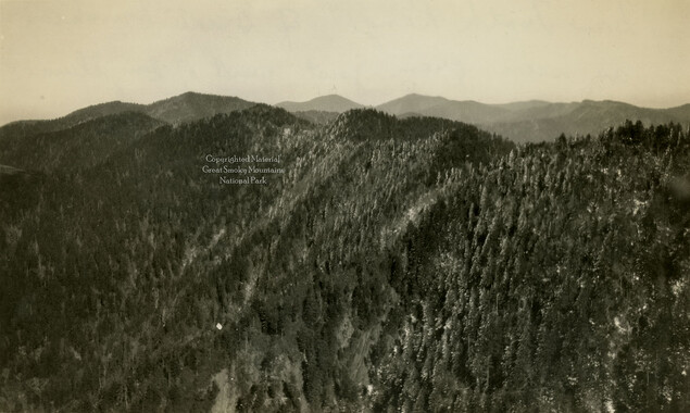
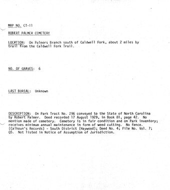
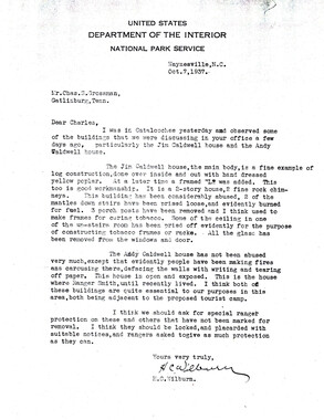
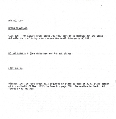
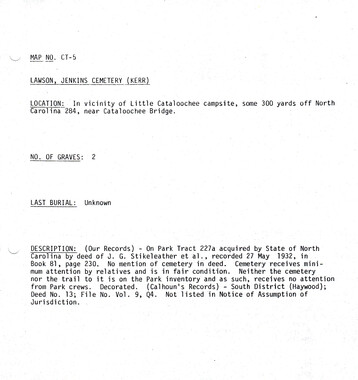
, .. CATALOOCHEE HISTORIC DISTRICT: CULTURAL LANDSCAPE REPORT GREAT SMOKY MOUNTAINS NATIONAL PARK January 2000 Dianne L. Flaugh Historical Landscape Architect Cultural Resources Resource Management Great Smoky Mountains National Park National Park Service I ~ 1'-/ I I I I ~ I ~ "_/ I I I I I I I I , ________ CHAPTER 4: INDIVIDUAL TRACTS " 77 Palmer Methodist Church and Cemetery Tract (218) Location Tract 218 is a 1.4 7 -acre parcel located north of Cataloochee Creek below the juncture of Palmer Creek and Rough Fork. The cemetery is found short distance from the church. It lies north of the CCC road on a steep side slope ofNoland Mountain on Milia Palmer tract 219. History The church tract was once part of a larger one hundred fifty acre tract purchased by Jesse Palmer in 1857. Elizabeth Palmer (daughter) inherited approximately fifty-five acres from her father's estate. When she died in 1896, the property passed to her mother, Mary A. Palmer. That same year, Mary Palmer sold this tract to the church trustees for $20 "for and in consideration of the love that I bear to the Christian religion."' The North Carolina Park Commission purchased the church lot in 1930, for $1, 150~ Little is known of the early use of what became the church lot. It probably was once part of a larger agricultural field. In 1898, a movement to replace the first church (located between the present day ranger station and the campground) began. Charlie and Taylor Medford, carpenters from the Iron Duff section of Haywood County, were hired to build the new church. Church members donated some of their best trees for the lumber, which were sawn on a portable mill about one half mile upstream of the Hiram Caldwell house. Information obtained from Gudger Palmer, Jarvis Caldwell, Eston Caldwell, and Floyd Woody yields a construction date of 1902. However, this conflicts with the statement of Charlie Medford, who states that construction was begun in April 1899, and completed that same summer.2 There is little information concerning land use on the church parcel during the years of 1896 to 1929. According to Gudger Palmer, a barn sat in the field behind the church, close to the CCC road.3 Mark and Harold Hannah recall that the field was open pasture and livestock grazed right up to the church.4 A photograph (ca. 1937) shows a fence, gate, and barn behind the church as well as an informal parking area in front of the building (figure 25). Virtually no information exists concerning the cemetery. It is not known if land for the cemetery was purchased, donated, or remained a part of tract 219. There is no information about its maintenance or historic appearance. Some of the early settlers of Cataloochee are interred there including Levi Caldwell and Young Bennett. Inscriptions on grave markers (dates of death from 1864 through the early 1880s) in the cemetery indicate use .ofthe site as a cemetery prior to the construction ofPalmer Methodist Church. · Vegetation There is little information concerning vegetation on the church lot. Both survey drawings (ca. 1935) and a circa 1937 photograph indicate that the grounds were kept cleared of 78 CULTURAL LANDSCAPE REPORT: CATALOOCHEE HisTORIC DISTRICT trees except along fence lines and streams at the lot perimeter. The 1938 Miller vegetation type map indicates that area of the cemetery was cleared land. A vegetation study of the Cataloochee area completed in 1997 supports this.5 Circulation The old settler road ran along Cataloochee Creek at the front of the church building. Gudger Palmer recalls that Cooks Lane ran between two fence lines and along the branch east of the church to connect with the old settler road. 6 During the 1940s the CCC built a new road through the meadows of Cataloochee. It replaced the old settler road through this portion of Cataloochee. This CCC road cut through the bottom land fields ofthe D. W. Caldwell tract north of the church leaving the church to face a little used trace road. Structures, Furnishings, and Objects Figure 25. Looking northwest at Palmer Methodist Church from historic trace road, 1937. GRSM Archives. NCPC records indicate that the property consisted of the lot and a 30' by 40' frame building. The congregation upgraded the building using money from the property sale. Remodeling included applying wetlaid river rock foundation infill between stone piers, building a bell tower, and installing a new bell. It is probable that the metal shingle roof was installed at this time. A flat stone, laid into the foundation, with the date 1929 incised into its face, documents these alterations to the structure. Initially, members of the congregation maintained the church building after its sale to the North Carolina Park Commission and the park was responsible for mowing the grounds. Sometime between 1930, and 1960, the NPS took on the maintenance ofboth building and grounds. Between 1980, and 1990, park preservation crews undertook work on the building. Work has included repainting the structure, replacing the metal shingle roof in kind, and the placement of french drains along the length ofthe church.7 Survey drawings (ca. 1935) indicate that the church was bounded on the south by the old settler road and Cataloochee Creek, and to the northeast and northwest by fences. A photograph (ca. 193 7) indicates that a wooden fence and gate stood on the northwest perimeter but gives no clear indication of its construction. The existing worm rail fence •• I I I CHAPTER 4: INDIVIDUAL TRACTS was installed (ca. 1970) parallel to the CCC road in an effort to deter parking on the grassy area behind the church. ·79 Little is known ofthe historic appearance of the Palmer Methodist Church Cemetery. Inscriptions on grave markers in the cemetery indicate use of the site as a cemetery prior to the construction ofPalmer Methodist Church. Several of the early settlers of Cataloochee are buried here including Levi B. Caldwell and Young Bennett. Existing Conditions Palmer Methodist Church is designated as a historic preservation area. Currently, the primary use of the church is as a historic interpretive exhibit. The church is also used for weddings and similar events. The largest annual event held at the Church is the Cataloochee homecoming. Each August former residents and their descendants gather together for food and fellowship. The former pasture north of the Church is used for vehicular parking during these large events. It is unknown when the pasture behind the church was converted to grass. However, several sources don't recall the area being anything but grass for the past twenty to fifty years. Maintenance crews keep the area neatly mown. A line oftrees consisting ofhornbeams, maples, walnuts, and birches is found to the rear of the church structure. It demarcates the approximate location of the historic fence line separating the church property from the adjacent pasture. Cataloochee Creek Road (CCC built road) provides vehicular access to the church site. The pavement ends in front of the church and the road surface changes to gravel. Visitors parallel park along the edge of the road. The trace of the old settler road running along Cataloochee Creek remains evident on the church lot. The trace is used by visitors to the site, exploring the creek or visiting the two comfort stations that stand along side the trace road (figure 26). Cooks Lane in the immediate vicinity of Palmer Methodist Church Cemetery is evident but beyond the cemetery entrance it becomes impossible to track. Figure 26. Historic trace road near church, 1996. 80 CUL11JRAL LANDSCAPE REPORT: CATALOOCHEE HlsTORIC DISTRICT Pahner Methodist Church Cemetery has been maintained as open but is surrounded on all sides by forest dominated by maples and oaks. The Park includes the cemetery in its yearly cemetery maintenance schedule. It contains approximately one hundred graves, many of which are marked by uninscribed limestone or concrete markers. The most recent burial in this cemetery occurred in 1969. Remnants of wood post and wire fencing extends around the perimeter of the cemetery. A small sign along Cataloochee Creek Road marks the trail leading to the cemetery. Analysis and Evaluation This site is associated with community life in Cataloochee. This site retains much of its historic landscape character. Landscape elements including the church building, trace road, and the openness of the surrounding land contribute to this character. While the fence line that once separated the church lot from the adjacent pasture is now missing, a line of trees does provide a sense of separation. Although the site does retain much of its historic character there are landscape elements that detract. This includes the NPS added worm rail fencing along Cataloochee Creek Road. Fencing along road is needed to control vehicular access to the site, and a fence style more typical of that used as field fencing would be appropriate. The approach taken by visitors to the church changed with the construction of the CCC built road. Visitors no longer approach the front ofthe church from the established road. Rather, they walk through what was once a field to the rear of the church. NOTES 1 Ed Trout. "Draft Cataloochee Historic Structures Reports: Palmer Chapel, Beech Grove School, and Little Cataloochee Baptist Church," (Great Smoky Mountains National Park, [1989/90]), 3. 2 Ibid., 3-4. 3 Gudger Palmer, Interview by Jacqueline Lott and author, Written notes, Cataloochee, NC, 27 March 1998. 4 Mark Hannah and Harold Hannah, Interview by Jacqueline Lott. Written notes, Abingdon, VA, 28 October 1996. 5 "A ·vegetation Survey of Cultural Management Zones in the Cataloochee Area of the Great Smoky Mountains National Park," Great Smoky Mountains National Park, Resource Management, May 1997, 41-43. Frank Miller, Vegetative Types in the Great Smoky Mountains, September 1938, GRSM Archives, GRSM-16582-a. 6 Gudger Palmer, 27 March 1998. 7 Trout. 6-7. I • I I I I I I I I I I I I I I I I
Object’s are ‘parent’ level descriptions to ‘children’ items, (e.g. a book with pages).
-
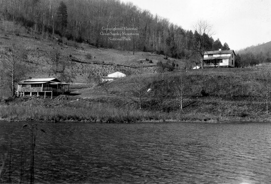
This 1.5-acre tract 218 in Cataloochee was owned by Palmer’s Chapel Church. The Palmer Chapel is among the few preserved structures that remain today in Big Cataloochee. While, in general, the Great Smoky Mountains region was sparsely populated, the Cataloochee Valley remained an exception. By 1900, the population of Cataloochee had grown to 1,000 residents living in hundreds of log and frame homes. A few historic buildings have been preserved on site, including two churches, a school, several homes, and outbuildings. The North Carolina Park Commission was tasked with purchasing land for the Great Smoky Mountains National Park and people living in Cataloochee were among those displaced. Cataloochee families continue to return for annual reunions. In 2001, the National Park Service re-introduced elk into the valley.
-


Part of Collection
Great Smoky Mountains - A Park for America