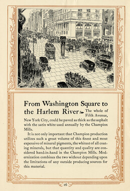
- Canton Champion Fibre Company (2308)
- Cherokee Traditions (291)
- Civil War in Southern Appalachia (165)
- Craft Revival (1942)
- George Masa Collection (137)
- Great Smoky Mountains - A Park for America (2900)
- Highlights from Western Carolina University (422)
- Horace Kephart (941)
- Journeys Through Jackson (159)
- LGBTQIA+ Archive of Jackson County (85)
- Oral Histories of Western North Carolina (314)
- Picturing Appalachia (6797)
- Stories of Mountain Folk (413)
- Travel Western North Carolina (153)
- Western Carolina University Fine Art Museum Vitreograph Collection (129)
- Western Carolina University Herbarium (92)
- Western Carolina University: Making Memories (738)
- Western Carolina University Publications (2491)
- Western Carolina University Restricted Electronic Theses and Dissertations (146)
- Western North Carolina Regional Maps (71)
- World War II in Southern Appalachia (131)
- Allanstand Cottage Industries (62)
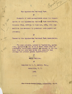
- Appalachian National Park Association (53)
- Bennett, Kelly, 1890-1974 (1463)
- Berry, Walter (76)
- Brasstown Carvers (40)
- Carver, George Washington, 1864?-1943 (26)
- Cathey, Joseph, 1803-1874 (1)
- Champion Fibre Company (233)
- Champion Paper and Fibre Company (297)
- Cherokee Indian Fair Association (16)
- Cherokee Language Program (22)
- Crowe, Amanda (40)
- Edmonston, Thomas Benton, 1842-1907 (7)
- Ensley, A. L. (Abraham Lincoln), 1865-1948 (275)
- Fromer, Irving Rhodes, 1913-1994 (70)
- George Butz (BFS 1907) (46)
- Goodrich, Frances Louisa (120)
- Grant, George Alexander, 1891-1964 (96)
- Heard, Marian Gladys (60)
- Kephart, Calvin, 1883-1969 (15)
- Kephart, Horace, 1862-1931 (313)
- Kephart, Laura, 1862-1954 (39)
- Laney, Gideon Thomas, 1889-1976 (439)
- Masa, George, 1881-1933 (61)
- McElhinney, William Julian, 1896-1953 (44)
- Niggli, Josephina, 1910-1983 (10)
- North Carolina Park Commission (105)
- Osborne, Kezia Stradley (9)
- Owens, Samuel Robert, 1918-1995 (11)
- Penland Weavers and Potters (36)
- Roberts, Vivienne (15)
- Roth, Albert, 1890-1974 (142)
- Schenck, Carl Alwin, 1868-1955 (1)
- Sherrill's Photography Studio (2565)
- Southern Highland Handicraft Guild (127)
- Southern Highlanders, Inc. (71)
- Stalcup, Jesse Bryson (46)
- Stearns, I. K. (213)
- Thompson, James Edward, 1880-1976 (226)
- United States. Indian Arts and Crafts Board (130)
- USFS (683)
- Vance, Zebulon Baird, 1830-1894 (1)
- Weaver, Zebulon, 1872-1948 (58)
- Western Carolina College (230)
- Western Carolina Teachers College (282)
- Western Carolina University (2008)
- Western Carolina University. Mountain Heritage Center (18)
- Whitman, Walt, 1819-1892 (10)
- Wilburn, Hiram Coleman, 1880-1967 (73)
- Williams, Isadora (3)
- Cain, Doreyl Ammons (0)
- Crittenden, Lorraine (0)
- Rhodes, Judy (0)
- Smith, Edward Clark (0)
- Appalachian Region, Southern (2929)
- Asheville (N.C.) (1944)
- Avery County (N.C.) (26)
- Blount County (Tenn.) (195)
- Buncombe County (N.C.) (1680)
- Cherokee County (N.C.) (283)
- Clay County (N.C.) (556)
- Graham County (N.C.) (238)
- Great Smoky Mountains National Park (N.C. and Tenn.) (525)
- Haywood County (N.C.) (3571)
- Henderson County (N.C.) (70)
- Jackson County (N.C.) (4917)
- Knox County (Tenn.) (35)
- Knoxville (Tenn.) (13)
- Lake Santeetlah (N.C.) (10)
- Macon County (N.C.) (420)
- Madison County (N.C.) (216)
- McDowell County (N.C.) (39)
- Mitchell County (N.C.) (135)
- Polk County (N.C.) (35)
- Qualla Boundary (982)
- Rutherford County (N.C.) (78)
- Swain County (N.C.) (2185)
- Transylvania County (N.C.) (270)
- Watauga County (N.C.) (12)
- Waynesville (N.C.) (86)
- Yancey County (N.C.) (72)
- Aerial Photographs (3)
- Aerial Views (60)
- Albums (books) (4)
- Articles (1)
- Artifacts (object Genre) (228)
- Bibliographies (1)
- Biography (general Genre) (2)
- Cards (information Artifacts) (38)
- Clippings (information Artifacts) (191)
- Copybooks (instructional Materials) (3)
- Crafts (art Genres) (622)
- Depictions (visual Works) (21)
- Design Drawings (1)
- Drawings (visual Works) (185)
- Envelopes (73)
- Exhibitions (events) (1)
- Facsimiles (reproductions) (1)
- Fiction (general Genre) (4)
- Financial Records (12)
- Fliers (printed Matter) (67)
- Glass Plate Negatives (381)
- Guidebooks (2)
- Internegatives (10)
- Interviews (815)
- Land Surveys (102)
- Letters (correspondence) (1013)
- Manuscripts (documents) (618)
- Maps (documents) (177)
- Memorandums (25)
- Minutes (administrative Records) (59)
- Negatives (photographs) (6090)
- Newsletters (1290)
- Newspapers (2)
- Notebooks (8)
- Occupation Currency (1)
- Paintings (visual Works) (1)
- Pen And Ink Drawings (1)
- Periodicals (193)
- Personal Narratives (10)
- Photographs (12976)
- Plans (maps) (1)
- Poetry (5)
- Portraits (4568)
- Postcards (329)
- Programs (documents) (181)
- Publications (documents) (2443)
- Questionnaires (65)
- Relief Prints (26)
- Sayings (literary Genre) (1)
- Scrapbooks (282)
- Sheet Music (2)
- Slides (photographs) (402)
- Songs (musical Compositions) (2)
- Sound Recordings (796)
- Specimens (92)
- Speeches (documents) (18)
- Tintypes (photographs) (8)
- Transcripts (322)
- Video Recordings (physical Artifacts) (23)
- Text Messages (0)
- A.L. Ensley Collection (275)
- Appalachian Industrial School Records (7)
- Appalachian National Park Association Records (336)
- Axley-Meroney Collection (2)
- Bayard Wootten Photograph Collection (20)
- Bethel Rural Community Organization Collection (7)
- Blumer Collection (5)
- C.W. Slagle Collection (20)
- Canton Area Historical Museum (2110)
- Carlos C. Campbell Collection (462)
- Cataloochee History Project (64)
- Cherokee Studies Collection (4)
- Daisy Dame Photograph Album (5)
- Daniel Boone VI Collection (1)
- Doris Ulmann Photograph Collection (112)
- Elizabeth H. Lasley Collection (1)
- Elizabeth Woolworth Szold Fleharty Collection (4)
- Frank Fry Collection (95)
- George Masa Collection (173)
- Gideon Laney Collection (452)
- Hazel Scarborough Collection (2)
- Hiram C. Wilburn Papers (28)
- Historic Photographs Collection (236)
- Horace Kephart Collection (861)
- Humbard Collection (33)
- Hunter and Weaver Families Collection (1)
- I. D. Blumenthal Collection (4)
- Isadora Williams Collection (4)
- Jesse Bryson Stalcup Collection (47)
- Jim Thompson Collection (224)
- John B. Battle Collection (7)
- John C. Campbell Folk School Records (80)
- John Parris Collection (6)
- Judaculla Rock project (2)
- Kelly Bennett Collection (1482)
- Love Family Papers (11)
- Major Wiley Parris Civil War Letters (3)
- Map Collection (12)
- McFee-Misemer Civil War Letters (34)
- Mountain Heritage Center Collection (4)
- Norburn - Robertson - Thomson Families Collection (44)
- Pauline Hood Collection (7)
- Pre-Guild Collection (2)
- Qualla Arts and Crafts Mutual Collection (12)
- R.A. Romanes Collection (681)
- Rosser H. Taylor Collection (1)
- Samuel Robert Owens Collection (94)
- Sara Madison Collection (144)
- Sherrill Studio Photo Collection (2558)
- Smoky Mountains Hiking Club Collection (616)
- Stories of Mountain Folk - Radio Programs (374)
- The Reporter, Western Carolina University (510)
- Venoy and Elizabeth Reed Collection (16)
- WCU Gender and Sexuality Oral History Project (32)
- WCU Mountain Heritage Center Oral Histories (25)
- WCU Oral History Collection - Mountain People, Mountain Lives (71)
- WCU Students Newspapers Collection (1923)
- Western North Carolina Tomorrow Black Oral History Project (69)
- William Williams Stringfield Collection (2)
- Zebulon Weaver Collection (109)
- African Americans (390)
- Appalachian Trail (35)
- Artisans (521)
- Cherokee art (84)
- Cherokee artists -- North Carolina (10)
- Cherokee language (21)
- Cherokee pottery (101)
- Cherokee women (208)
- Church buildings (190)
- Civilian Conservation Corps (U.S.) (111)
- College student newspapers and periodicals (2012)
- Dams (108)
- Dance (1023)
- Education (222)
- Floods (61)
- Folk music (1015)
- Forced removal, 1813-1903 (2)
- Forest conservation (220)
- Forests and forestry (1196)
- Gender nonconformity (4)
- Great Smoky Mountains National Park (N.C. and Tenn.) (181)
- Hunting (46)
- Landscape photography (25)
- Logging (119)
- Maps (83)
- Mines and mineral resources (9)
- North Carolina -- Maps (18)
- Paper industry (38)
- Postcards (255)
- Pottery (135)
- Railroad trains (72)
- Rural electrification -- North Carolina, Western (3)
- School integration -- Southern States (2)
- Segregation -- North Carolina, Western (5)
- Slavery (5)
- Sports (452)
- Storytelling (243)
- Waterfalls -- Great Smoky Mountains (N.C. and Tenn.) (66)
- Weaving -- Appalachian Region, Southern (280)
- Wood-carving -- Appalachian Region, Southern (328)
- World War, 1939-1945 (173)
Secretary of Agriculture report on watersheds

Secretary of Agriculture report on watersheds
NCWRA_019_12_04_07_01
Secretary of Agriculture report on watersheds
NCWRA_019_12_04_07_02
Secretary of Agriculture report on watersheds
NCWRA_019_12_04_07_03
Secretary of Agriculture report on watersheds
NCWRA_019_12_04_07_04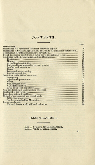
Secretary of Agriculture report on watersheds
NCWRA_019_12_04_07_05
Secretary of Agriculture report on watersheds
NCWRA_019_12_04_07_06
Secretary of Agriculture report on watersheds
NCWRA_019_12_04_07_07
Secretary of Agriculture report on watersheds
NCWRA_019_12_04_07_08
Secretary of Agriculture report on watersheds
NCWRA_019_12_04_07_09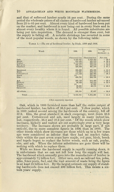
Secretary of Agriculture report on watersheds
NCWRA_019_12_04_07_10
Secretary of Agriculture report on watersheds
NCWRA_019_12_04_07_11
Secretary of Agriculture report on watersheds
NCWRA_019_12_04_07_12
Secretary of Agriculture report on watersheds
NCWRA_019_12_04_07_13
Secretary of Agriculture report on watersheds
NCWRA_019_12_04_07_14
Secretary of Agriculture report on watersheds
NCWRA_019_12_04_07_15
Secretary of Agriculture report on watersheds
NCWRA_019_12_04_07_16
Secretary of Agriculture report on watersheds
NCWRA_019_12_04_07_17
Secretary of Agriculture report on watersheds
NCWRA_019_12_04_07_18
Secretary of Agriculture report on watersheds
NCWRA_019_12_04_07_19
Secretary of Agriculture report on watersheds
NCWRA_019_12_04_07_20
Secretary of Agriculture report on watersheds
NCWRA_019_12_04_07_21
Secretary of Agriculture report on watersheds
NCWRA_019_12_04_07_22
Secretary of Agriculture report on watersheds
NCWRA_019_12_04_07_23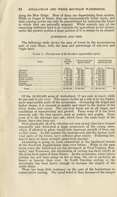
Secretary of Agriculture report on watersheds
NCWRA_019_12_04_07_24
Secretary of Agriculture report on watersheds
NCWRA_019_12_04_07_25
Secretary of Agriculture report on watersheds
NCWRA_019_12_04_07_26
Secretary of Agriculture report on watersheds
NCWRA_019_12_04_07_27
Secretary of Agriculture report on watersheds
NCWRA_019_12_04_07_28
Secretary of Agriculture report on watersheds
NCWRA_019_12_04_07_29
Secretary of Agriculture report on watersheds
NCWRA_019_12_04_07_30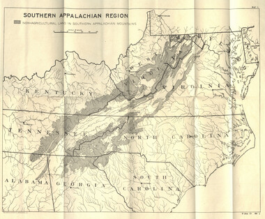
Secretary of Agriculture report on watersheds
NCWRA_019_12_04_07_30a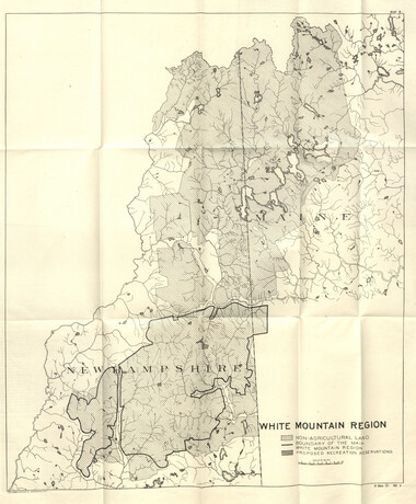
Secretary of Agriculture report on watersheds
NCWRA_019_12_04_07_30b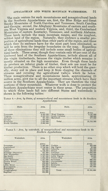
Secretary of Agriculture report on watersheds
NCWRA_019_12_04_07_31
Secretary of Agriculture report on watersheds
NCWRA_019_12_04_07_32
Secretary of Agriculture report on watersheds
NCWRA_019_12_04_07_33
Secretary of Agriculture report on watersheds
NCWRA_019_12_04_07_34
Secretary of Agriculture report on watersheds
NCWRA_019_12_04_07_35
Secretary of Agriculture report on watersheds
NCWRA_019_12_04_07_36
Secretary of Agriculture report on watersheds
NCWRA_019_12_04_07_37
Secretary of Agriculture report on watersheds
NCWRA_019_12_04_07_38
Secretary of Agriculture report on watersheds
NCWRA_019_12_04_07_39Item’s are ‘child’ level descriptions to ‘parent’ objects, (e.g. one page of a whole book).
-
-
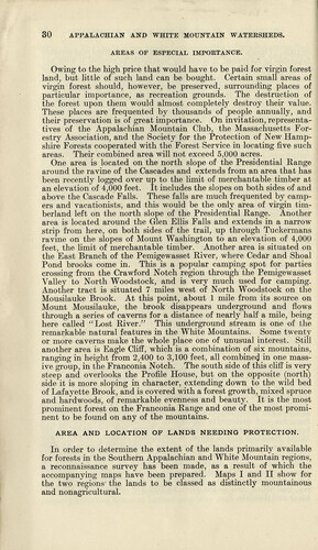
30 APPALACHIAN AND WHITE MOUNTAIN WATERSHEDS. AREAS OF ESPECIAL IMPORTANCE. Owing to the high price that would have to be paid for virgin forest land, but little of such land can be bought. Certain small areas of virgin forest should, however, be preserved, surrounding places of particular importance, as recreation grounds. The destruction of the forest upon them would almost completely destroy their value. These places are frequented by thousands of people annually, and their preservation is of great importance. On invitation, representatives of the Appalachian Mountain Club, the Massachusetts Forestry Association, and the Society for the Protection of New Hampshire Forests cooperated with the Forest Service in locating five such areas. Their combined area will not exceed 5,000 acres. One area is located on the north slope of the Presidential Range around the ravine of the Cascades and extends from an area that has been recently logged over up to the limit of merchantable timber at an elevation of 4,000 feet. It includes the slopes on both sides of and above the Cascade Falls. These falls are much frequented by campers and vacationists, and this would be the only area of virgin tim- berland left on the north slope of the Presidential Range. Another area is located around the Glen Ellis Falls and extends in a narrow strip from here, on both sides of the trail, up through Tuckermans ravine on the slopes of Mount Washington to an elevation of 4,000 feet, the limit of merchantable timber. Another area is situated on the East Branch of the Pemigewasset River, where Cedar and Shoal Pond brooks come in. This is a popular camping spot for parties crossing from the Crawford Notch region through the Pemigewasset Valley to North Woodstock, and is very much used for camping. Another tract is situated 7 miles west of North Woodstock on the Mousilauke Brook. At this point, about 1 mile from its source on Mount Mousilauke, the brook disappears underground and flows through a series of caverns for a distance of nearly half a mile, being here called "Lost River." This underground stream is one of the remarkable natural features in the White Mountains. Some twenty or more caverns make the whole place one of unusual interest. Still another area is Eagle Cliff, which is a combination of six mountains, ranging in height from 2,400 to 3,100 feet, all combined in one massive group, in the Franconia Notch. The south side of this cliff is very steep and overlooks the Profile House, but on the opposite (north) side it is more sloping in character, extending down to the wild bed of Lafayette Brook, and is covered with a forest growth, mixed spruce and hardwoods, of remarkable evenness and beauty. It is the most prominent forest on the Franconia Range and one of the most prominent to be found on any of the mountains. AREA AND LOCATION OF LANDS NEEDING PROTECTION. In order to determine the extent of the lands primarily available for forests in the Southern Appalachian and White Mountain regions, a reconnaissance survey has been made, as a result of which the accompanying maps have been prepared. Maps I and II show for the two regions the lands to be classed as distinctly mountainous and nonagricultural.
Object’s are ‘parent’ level descriptions to ‘children’ items, (e.g. a book with pages).
-
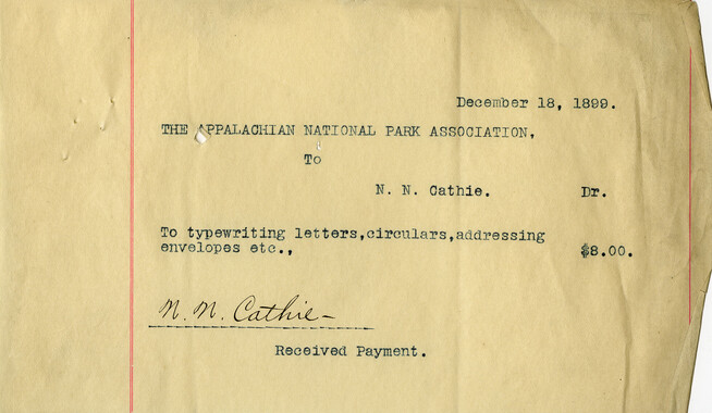
This 41-page “Report of the Secretary of Agriculture on The Southern Appalachian and White Mountain Watersheds” is in the collection of the Appalachian National Park Association records. The Senate report was written in 1907. Even before the dawn of the 20th century, the association raised awareness of the importance of forests to water.
-
Related items
-
Western Carolinian Volume 59 Number 21 (20)
-
Western Carolinian Volume 49 Number 21
-
Western Carolinian Volume 67 Number 10
-
Western North Carolina Section at a Glance
-
Western Carolinian Volume 40 Number 20
-
Western Carolinian Volume 44 Number 26

-
Western Carolinian Volume 70 Number 11
-
Western Carolinian Volume 34 Number 11
-
Western Carolinian Volume 52 Number 07
-
Western Carolinian Volume 32 Number 40
-
Western Carolinian Volume 67 Number 07

-
Western Carolinian Volume 46 Number 04
-
Western Carolinian Volume 69 Number 14

-
Western Carolinian Volume 52 Number 12
-
Western Carolinian Volume 28 Number 16
-
Western Carolinian Volume 64 (65) Number 09
-
Western Carolinian Volume 44 Number 05
-
Western Carolinian Volume 63 (64) Number 13
-
Western Carolinian Volume 42 Number 21

-
Western Carolinian Volume 61 Number 04 (05)
-
Western Carolinian Volume 35 Number 06
-
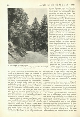
Nature Magazine: Carolina number
-
Western Carolinian Volume 54 Number 17
-
Handbook/ 1931/ Smoky Mountains Hiking Club

-
Western Carolinian Volume 73 Number 05

-
Western Carolinian Volume 41 Number 35
-
Western Carolinian Volume 61 Number 01

-
Nature Magazine: Carolina number
-
Western Carolinian Volume 70 Number 10
-
Western Carolinian Volume 70 Number 07

-
Western Carolinian Volume 51 Number 03
-
Western Carolinian Volume 35 Number 45
Part of Collection
Great Smoky Mountains - A Park for America
-
Correspondence between Chase Ambler and Jeter Pritchard

-
Strategies for supporting the Appalachian National Park movement

-
Interviews by Joe Hall about life in Cataloochee

-
Editorial: The Century magazine

-
Letters supporting Appalachian National Park movement

-
Southern Pictures and Pencillings correspondence

-
CCC officers at Camp NP-5 near Smokemont, N.C.
-
Financial receipts and expenditures, 1899
-
Great Smoky Mountains National Park: Tennessee Area

-
Handbook/ 1933/ Smoky Mountains Hiking Club

-
Report of the North Carolina Park Commission

-
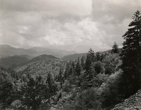
Mountain landscape
-
Cataloochee tract 251: James H. Hannah
-
Program of hikes for 1930/ Smoky Mountains Hiking Club

-
Nomenclature of Appalachian Mountains
-
Southern Pictures and Pencillings correspondence

-
Senator Pritchard's questions regarding the park movement
-
Appalachian National Park Association Newspaper Clippings, 1902-1907, 1925, 1928
-
Cataloochee tract 206a: Lou Palmer King

-
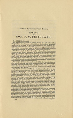
Senator Pritchard's Speech
-
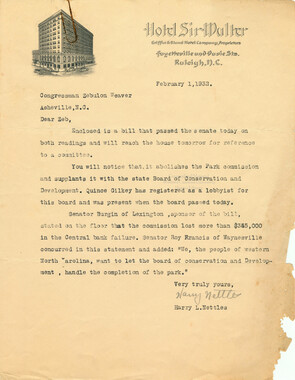
Correspondence: Harry L. Nettles to Zebulon Weaver, February 1, 1932
-
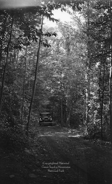
Big Creek Road
-
Financial receipts and expenditures, 1901

-
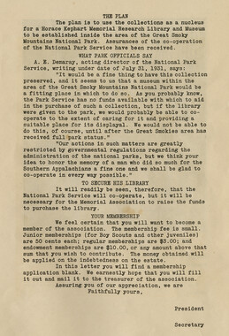
Horace Kephart Memorial Association
-
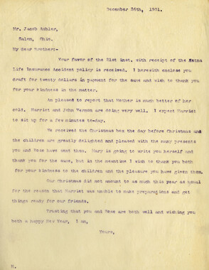
Correspondence: C. P. Ambler to Jacob Ambler
-
Handbook/ 1934/ Smoky Mountains Hiking Club

-
Local Party is back from trip to Smoky Park

-
Foundation of Quality: Organization/ Equipment/ Service
-
Correspondence: George Kephart to Michael Frome

-
Editorials commenting on the Appalachian National Park movement
-
Poison ivy

-
Hikers at Dry Sluice Gap
