- Canton Champion Fibre Company (2308)
- Cherokee Traditions (292)
- Civil War in Southern Appalachia (165)
- Craft Revival (1942)
- Great Smoky Mountains - A Park for America (2766)
- Highlights from Western Carolina University (430)
- Horace Kephart (941)
- Journeys Through Jackson (154)
- LGBTQIA+ Archive of Jackson County (85)
- Oral Histories of Western North Carolina (314)
- Picturing Appalachia (6772)
- Stories of Mountain Folk (413)
- Travel Western North Carolina (160)
- Western Carolina University Fine Art Museum Vitreograph Collection (129)
- Western Carolina University Herbarium (92)
- Western Carolina University: Making Memories (708)
- Western Carolina University Publications (2283)
- Western Carolina University Restricted Electronic Theses and Dissertations (146)
- Western North Carolina Regional Maps (71)
- World War II in Southern Appalachia (131)
- Allanstand Cottage Industries (62)
- Appalachian National Park Association (53)
- Bennett, Kelly, 1890-1974 (1388)
- Berry, Walter (76)
- Brasstown Carvers (40)
- Carver, George Washington, 1864?-1943 (26)
- Cathey, Joseph, 1803-1874 (1)
- Champion Fibre Company (233)
- Champion Paper and Fibre Company (297)
- Cherokee Indian Fair Association (16)
- Cherokee Language Program (22)
- Crowe, Amanda (40)
- Edmonston, Thomas Benton, 1842-1907 (7)
- Ensley, A. L. (Abraham Lincoln), 1865-1948 (275)
- Fromer, Irving Rhodes, 1913-1994 (70)
- George Butz (BFS 1907) (46)
- Goodrich, Frances Louisa (120)
- Grant, George Alexander, 1891-1964 (96)
- Heard, Marian Gladys (60)
- Kephart, Calvin, 1883-1969 (15)
- Kephart, Horace, 1862-1931 (313)
- Kephart, Laura, 1862-1954 (39)
- Laney, Gideon Thomas, 1889-1976 (439)
- Masa, George, 1881-1933 (61)
- McElhinney, William Julian, 1896-1953 (44)
- Niggli, Josephina, 1910-1983 (10)
- North Carolina Park Commission (105)
- Osborne, Kezia Stradley (9)
- Owens, Samuel Robert, 1918-1995 (11)
- Penland Weavers and Potters (36)
- Roberts, Vivienne (15)
- Roth, Albert, 1890-1974 (142)
- Schenck, Carl Alwin, 1868-1955 (1)
- Sherrill's Photography Studio (2565)
- Southern Highland Handicraft Guild (127)
- Southern Highlanders, Inc. (71)
- Stalcup, Jesse Bryson (46)
- Stearns, I. K. (213)
- Thompson, James Edward, 1880-1976 (226)
- United States. Indian Arts and Crafts Board (130)
- USFS (683)
- Vance, Zebulon Baird, 1830-1894 (1)
- Weaver, Zebulon, 1872-1948 (58)
- Western Carolina College (230)
- Western Carolina Teachers College (282)
- Western Carolina University (1794)
- Western Carolina University. Mountain Heritage Center (18)
- Whitman, Walt, 1819-1892 (10)
- Wilburn, Hiram Coleman, 1880-1967 (73)
- Williams, Isadora (3)
- Cain, Doreyl Ammons (0)
- Crittenden, Lorraine (0)
- Rhodes, Judy (0)
- Smith, Edward Clark (0)
- Appalachian Region, Southern (2569)
- Asheville (N.C.) (1923)
- Avery County (N.C.) (26)
- Blount County (Tenn.) (161)
- Buncombe County (N.C.) (1672)
- Cherokee County (N.C.) (283)
- Clay County (N.C.) (555)
- Graham County (N.C.) (233)
- Great Smoky Mountains National Park (N.C. and Tenn.) (519)
- Haywood County (N.C.) (3524)
- Henderson County (N.C.) (70)
- Jackson County (N.C.) (4694)
- Knox County (Tenn.) (25)
- Knoxville (Tenn.) (12)
- Lake Santeetlah (N.C.) (10)
- Macon County (N.C.) (420)
- Madison County (N.C.) (212)
- McDowell County (N.C.) (39)
- Mitchell County (N.C.) (132)
- Polk County (N.C.) (35)
- Qualla Boundary (981)
- Rutherford County (N.C.) (76)
- Swain County (N.C.) (2115)
- Transylvania County (N.C.) (270)
- Watauga County (N.C.) (12)
- Waynesville (N.C.) (84)
- Yancey County (N.C.) (72)
- Aerial Photographs (3)
- Aerial Views (60)
- Albums (books) (4)
- Articles (1)
- Artifacts (object Genre) (228)
- Bibliographies (1)
- Biography (general Genre) (2)
- Cards (information Artifacts) (38)
- Clippings (information Artifacts) (191)
- Crafts (art Genres) (622)
- Depictions (visual Works) (21)
- Design Drawings (1)
- Drawings (visual Works) (184)
- Envelopes (73)
- Facsimiles (reproductions) (1)
- Fiction (general Genre) (4)
- Financial Records (12)
- Fliers (printed Matter) (67)
- Glass Plate Negatives (381)
- Guidebooks (2)
- Internegatives (10)
- Interviews (815)
- Land Surveys (102)
- Letters (correspondence) (1013)
- Manuscripts (documents) (618)
- Maps (documents) (177)
- Memorandums (25)
- Minutes (administrative Records) (59)
- Negatives (photographs) (5835)
- Newsletters (1285)
- Newspapers (2)
- Occupation Currency (1)
- Paintings (visual Works) (1)
- Pen And Ink Drawings (1)
- Periodicals (193)
- Personal Narratives (10)
- Photographs (12976)
- Plans (maps) (1)
- Poetry (6)
- Portraits (4533)
- Postcards (329)
- Programs (documents) (151)
- Publications (documents) (2236)
- Questionnaires (65)
- Scrapbooks (282)
- Sheet Music (2)
- Slides (photographs) (402)
- Songs (musical Compositions) (2)
- Sound Recordings (796)
- Specimens (92)
- Speeches (documents) (15)
- Tintypes (photographs) (8)
- Transcripts (322)
- Video Recordings (physical Artifacts) (23)
- Vitreographs (129)
- Text Messages (0)
- A.L. Ensley Collection (275)
- Appalachian Industrial School Records (7)
- Appalachian National Park Association Records (336)
- Axley-Meroney Collection (2)
- Bayard Wootten Photograph Collection (20)
- Bethel Rural Community Organization Collection (7)
- Blumer Collection (5)
- C.W. Slagle Collection (20)
- Canton Area Historical Museum (2110)
- Carlos C. Campbell Collection (282)
- Cataloochee History Project (64)
- Cherokee Studies Collection (4)
- Daisy Dame Photograph Album (5)
- Daniel Boone VI Collection (1)
- Doris Ulmann Photograph Collection (112)
- Elizabeth H. Lasley Collection (1)
- Elizabeth Woolworth Szold Fleharty Collection (4)
- Frank Fry Collection (95)
- George Masa Collection (173)
- Gideon Laney Collection (452)
- Hazel Scarborough Collection (2)
- Hiram C. Wilburn Papers (28)
- Historic Photographs Collection (236)
- Horace Kephart Collection (861)
- Humbard Collection (33)
- Hunter and Weaver Families Collection (1)
- I. D. Blumenthal Collection (4)
- Isadora Williams Collection (4)
- Jesse Bryson Stalcup Collection (47)
- Jim Thompson Collection (224)
- John B. Battle Collection (7)
- John C. Campbell Folk School Records (80)
- John Parris Collection (6)
- Judaculla Rock project (2)
- Kelly Bennett Collection (1407)
- Love Family Papers (11)
- Major Wiley Parris Civil War Letters (3)
- Map Collection (12)
- McFee-Misemer Civil War Letters (34)
- Mountain Heritage Center Collection (4)
- Norburn - Robertson - Thomson Families Collection (44)
- Pauline Hood Collection (7)
- Pre-Guild Collection (2)
- Qualla Arts and Crafts Mutual Collection (12)
- R.A. Romanes Collection (681)
- Rosser H. Taylor Collection (1)
- Samuel Robert Owens Collection (94)
- Sara Madison Collection (144)
- Sherrill Studio Photo Collection (2558)
- Smoky Mountains Hiking Club Collection (616)
- Stories of Mountain Folk - Radio Programs (374)
- The Reporter, Western Carolina University (510)
- Venoy and Elizabeth Reed Collection (16)
- WCU Gender and Sexuality Oral History Project (32)
- WCU Mountain Heritage Center Oral Histories (25)
- WCU Oral History Collection - Mountain People, Mountain Lives (71)
- WCU Students Newspapers Collection (1744)
- Western North Carolina Tomorrow Black Oral History Project (69)
- William Williams Stringfield Collection (2)
- Zebulon Weaver Collection (109)
- African Americans (390)
- Appalachian Trail (35)
- Artisans (521)
- Cherokee art (84)
- Cherokee artists -- North Carolina (10)
- Cherokee language (21)
- Cherokee pottery (101)
- Cherokee women (208)
- Church buildings (170)
- Civilian Conservation Corps (U.S.) (110)
- College student newspapers and periodicals (1830)
- Dams (107)
- Dance (1023)
- Education (222)
- Floods (61)
- Folk music (1015)
- Forced removal, 1813-1903 (2)
- Forest conservation (220)
- Forests and forestry (1184)
- Gender nonconformity (4)
- Great Smoky Mountains National Park (N.C. and Tenn.) (181)
- Hunting (38)
- Landscape photography (25)
- Logging (118)
- Maps (83)
- Mines and mineral resources (8)
- North Carolina -- Maps (18)
- Paper industry (38)
- Postcards (255)
- Pottery (135)
- Railroad trains (71)
- Rural electrification -- North Carolina, Western (3)
- School integration -- Southern States (2)
- Segregation -- North Carolina, Western (5)
- Slavery (5)
- Sports (452)
- Storytelling (244)
- Waterfalls -- Great Smoky Mountains (N.C. and Tenn.) (66)
- Weaving -- Appalachian Region, Southern (280)
- Wood-carving -- Appalachian Region, Southern (328)
- World War, 1939-1945 (173)
Handbook/ 1931/ Smoky Mountains Hiking Club
Handbook/ 1931/ Smoky Mountains Hiking Club
GSMNP_13150_53_02_1138_01
Handbook/ 1931/ Smoky Mountains Hiking Club
GSMNP_13150_53_02_1138_02
Handbook/ 1931/ Smoky Mountains Hiking Club
GSMNP_13150_53_02_1138_03
Handbook/ 1931/ Smoky Mountains Hiking Club
GSMNP_13150_53_02_1138_04
Handbook/ 1931/ Smoky Mountains Hiking Club
GSMNP_13150_53_02_1138_05
Handbook/ 1931/ Smoky Mountains Hiking Club
GSMNP_13150_53_02_1138_06
Handbook/ 1931/ Smoky Mountains Hiking Club
GSMNP_13150_53_02_1138_07
Handbook/ 1931/ Smoky Mountains Hiking Club
GSMNP_13150_53_02_1138_08
Handbook/ 1931/ Smoky Mountains Hiking Club
GSMNP_13150_53_02_1138_09
Handbook/ 1931/ Smoky Mountains Hiking Club
GSMNP_13150_53_02_1138_10
Handbook/ 1931/ Smoky Mountains Hiking Club
GSMNP_13150_53_02_1138_11
Handbook/ 1931/ Smoky Mountains Hiking Club
GSMNP_13150_53_02_1138_12
Handbook/ 1931/ Smoky Mountains Hiking Club
GSMNP_13150_53_02_1138_13
Handbook/ 1931/ Smoky Mountains Hiking Club
GSMNP_13150_53_02_1138_14
Handbook/ 1931/ Smoky Mountains Hiking Club
GSMNP_13150_53_02_1138_15
Handbook/ 1931/ Smoky Mountains Hiking Club
GSMNP_13150_53_02_1138_16
Handbook/ 1931/ Smoky Mountains Hiking Club
GSMNP_13150_53_02_1138_17
Handbook/ 1931/ Smoky Mountains Hiking Club
GSMNP_13150_53_02_1138_18
Handbook/ 1931/ Smoky Mountains Hiking Club
GSMNP_13150_53_02_1138_19
Handbook/ 1931/ Smoky Mountains Hiking Club
GSMNP_13150_53_02_1138_20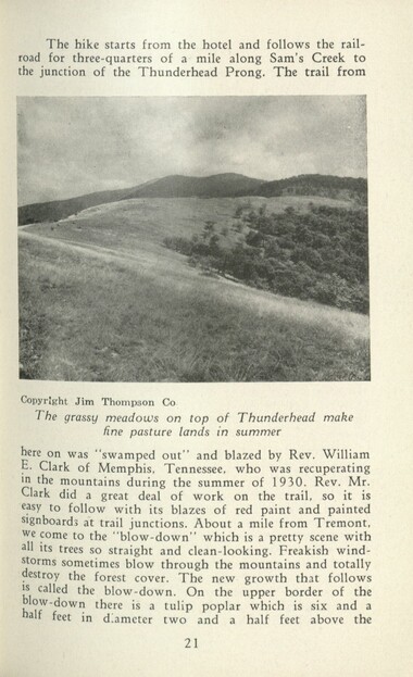
Handbook/ 1931/ Smoky Mountains Hiking Club
GSMNP_13150_53_02_1138_21
Handbook/ 1931/ Smoky Mountains Hiking Club
GSMNP_13150_53_02_1138_22
Handbook/ 1931/ Smoky Mountains Hiking Club
GSMNP_13150_53_02_1138_23
Handbook/ 1931/ Smoky Mountains Hiking Club
GSMNP_13150_53_02_1138_24
Handbook/ 1931/ Smoky Mountains Hiking Club
GSMNP_13150_53_02_1138_25
Handbook/ 1931/ Smoky Mountains Hiking Club
GSMNP_13150_53_02_1138_26
Handbook/ 1931/ Smoky Mountains Hiking Club
GSMNP_13150_53_02_1138_27
Handbook/ 1931/ Smoky Mountains Hiking Club
GSMNP_13150_53_02_1138_28
Handbook/ 1931/ Smoky Mountains Hiking Club
GSMNP_13150_53_02_1138_29
Handbook/ 1931/ Smoky Mountains Hiking Club
GSMNP_13150_53_02_1138_30
Handbook/ 1931/ Smoky Mountains Hiking Club
GSMNP_13150_53_02_1138_31
Handbook/ 1931/ Smoky Mountains Hiking Club
GSMNP_13150_53_02_1138_32
Handbook/ 1931/ Smoky Mountains Hiking Club
GSMNP_13150_53_02_1138_33
Handbook/ 1931/ Smoky Mountains Hiking Club
GSMNP_13150_53_02_1138_34
Handbook/ 1931/ Smoky Mountains Hiking Club
GSMNP_13150_53_02_1138_35
Handbook/ 1931/ Smoky Mountains Hiking Club
GSMNP_13150_53_02_1138_36
Handbook/ 1931/ Smoky Mountains Hiking Club
GSMNP_13150_53_02_1138_37
Handbook/ 1931/ Smoky Mountains Hiking Club
GSMNP_13150_53_02_1138_38
Handbook/ 1931/ Smoky Mountains Hiking Club
GSMNP_13150_53_02_1138_39
Handbook/ 1931/ Smoky Mountains Hiking Club
GSMNP_13150_53_02_1138_40
Handbook/ 1931/ Smoky Mountains Hiking Club
GSMNP_13150_53_02_1138_41
Handbook/ 1931/ Smoky Mountains Hiking Club
GSMNP_13150_53_02_1138_42
Handbook/ 1931/ Smoky Mountains Hiking Club
GSMNP_13150_53_02_1138_43
Handbook/ 1931/ Smoky Mountains Hiking Club
GSMNP_13150_53_02_1138_44
Handbook/ 1931/ Smoky Mountains Hiking Club
GSMNP_13150_53_02_1138_45
Handbook/ 1931/ Smoky Mountains Hiking Club
GSMNP_13150_53_02_1138_46
Handbook/ 1931/ Smoky Mountains Hiking Club
GSMNP_13150_53_02_1138_47
Handbook/ 1931/ Smoky Mountains Hiking Club
GSMNP_13150_53_02_1138_48
Handbook/ 1931/ Smoky Mountains Hiking Club
GSMNP_13150_53_02_1138_49
Handbook/ 1931/ Smoky Mountains Hiking Club
GSMNP_13150_53_02_1138_50
Handbook/ 1931/ Smoky Mountains Hiking Club
GSMNP_13150_53_02_1138_51
Handbook/ 1931/ Smoky Mountains Hiking Club
GSMNP_13150_53_02_1138_52
Handbook/ 1931/ Smoky Mountains Hiking Club
GSMNP_13150_53_02_1138_53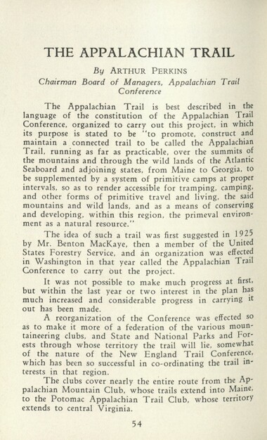
Handbook/ 1931/ Smoky Mountains Hiking Club
GSMNP_13150_53_02_1138_54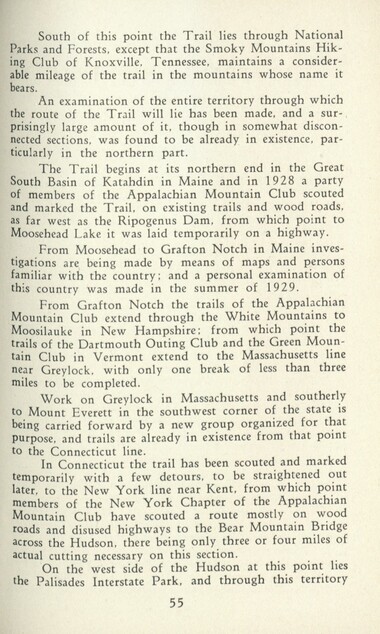
Handbook/ 1931/ Smoky Mountains Hiking Club
GSMNP_13150_53_02_1138_55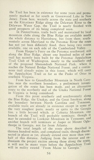
Handbook/ 1931/ Smoky Mountains Hiking Club
GSMNP_13150_53_02_1138_56
Handbook/ 1931/ Smoky Mountains Hiking Club
GSMNP_13150_53_02_1138_57
Handbook/ 1931/ Smoky Mountains Hiking Club
GSMNP_13150_53_02_1138_58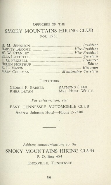
Handbook/ 1931/ Smoky Mountains Hiking Club
GSMNP_13150_53_02_1138_59
Handbook/ 1931/ Smoky Mountains Hiking Club
GSMNP_13150_53_02_1138_60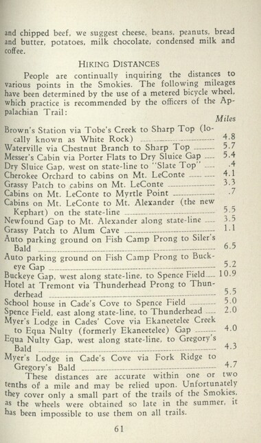
Handbook/ 1931/ Smoky Mountains Hiking Club
GSMNP_13150_53_02_1138_61
Handbook/ 1931/ Smoky Mountains Hiking Club
GSMNP_13150_53_02_1138_62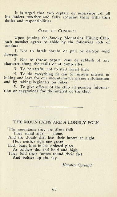
Handbook/ 1931/ Smoky Mountains Hiking Club
GSMNP_13150_53_02_1138_63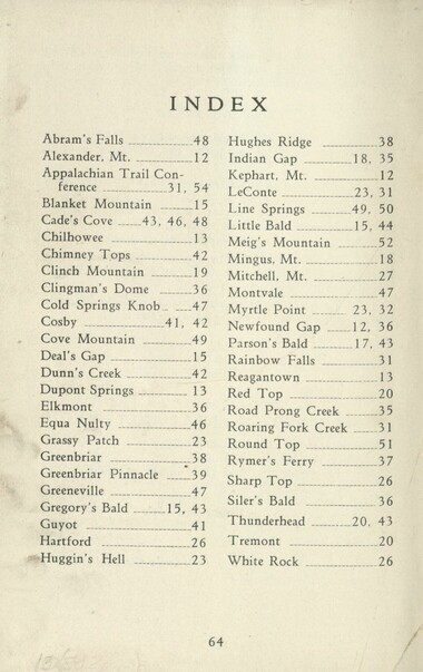
Handbook/ 1931/ Smoky Mountains Hiking Club
GSMNP_13150_53_02_1138_64
Handbook/ 1931/ Smoky Mountains Hiking Club
GSMNP_13150_53_02_1138_65_a
Handbook/ 1931/ Smoky Mountains Hiking Club
GSMNP_13150_53_02_1138_65_b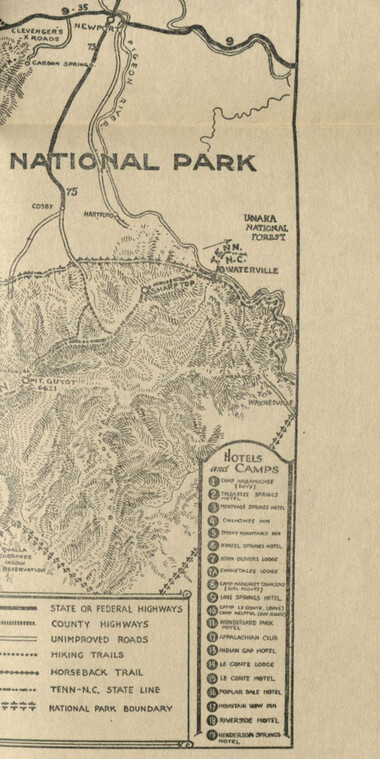
Handbook/ 1931/ Smoky Mountains Hiking Club
GSMNP_13150_53_02_1138_65_c
Handbook/ 1931/ Smoky Mountains Hiking Club
GSMNP_13150_53_02_1138_66Item’s are ‘child’ level descriptions to ‘parent’ objects, (e.g. one page of a whole book).
-
-
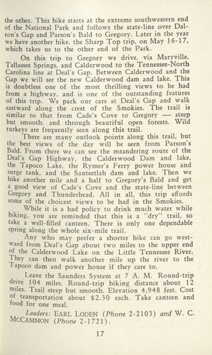
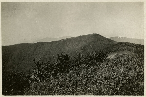
the other. This hike starts at the extreme southwestern end of the National Park and follows the state-line over Dal- ton's Gap and Parson's Bald to Gregory. Later in the year we have another hike, the Sharp Top trip, on May 16-17, which takes us to the other end of the Park. On this trip to Gregory we drive, via Maryville, Tallassee Springs, and Calderwood to the Tennessee-North Carolina line at Deal's Gap. Between Calderwood and the Gap we will see the new Calderwood dam and lake. This is doubtless one of the most thrilling views to be had from a highway, and is one of the outstanding features of this trip. We park our cars at Deal's, Gap and walk eastward along the crest of the Smokies. The trail is similar to that from Cade's Cove to Gregory — steep but smooth, and through beautiful open forests. Wild turkeys are frequently seen along this trail. There are many outlook points along this trail, but the best views of the day will be seen from Parson's Bald. From there we can see the meandering route of the Deal's Gap Highway, the Calderwood Dam and lake, the Tapoco Lake, the Rymer's Ferry power house and surge tank, and the Santeetlah dam and lake. Then we hike another mile and a half to Gregory's Bald and get a good view of Cade's Cove and the state-line between Gregory and Thunderhead. All in all, this trip affords some of the choicest views to be had in the Smokies. While it is a bad policy to drink much water while hiking, you are reminded that this is a "dry" trail, so take a well-filled canteen. There is only one dependable spring along the whole six-mile trail. Any who may prefer a shorter hike can go westward from Deal's Gap about two miles to the upper end of the Calderwood Lake on the Little Tennessee River. They can then walk another mile up the river to the Tapoco dam and power house if they care to. Leave the Saunders System at 7 A. M. Round-trip drive 104 miles. Round-trip hiking distance about 12 miles. Trail steep but smooth. Elevation 4,948 feet. Cost of transportation about $2.30 each. Take canteen and food for one meal. Leaders: EARL LODEN (Phone 2-2103) and W. C. MCCAMMON (Phone 2-1721). 17
Object’s are ‘parent’ level descriptions to ‘children’ items, (e.g. a book with pages).
-
In 1926, the Smoky Mountains Hiking Club began to print an annual handbook that outlined scheduled hikes for each month of the year, including winter. This 1931 handbook was collected by George Masa (1881-1933), a photographer active in the Appalachian Trail Club and in the movement to establish the Great Smoky Mountains National Park. The Smoky Mountains Hiking Club was formed after a group of outdoor enthusiasts hiked up to Mount LeConte in October 1924. Enjoying the spectacular views, the group returned to establish a formal hiking club to sponsor regularly-scheduled hikes into the Great Smoky Mountains.
-
Related items
-
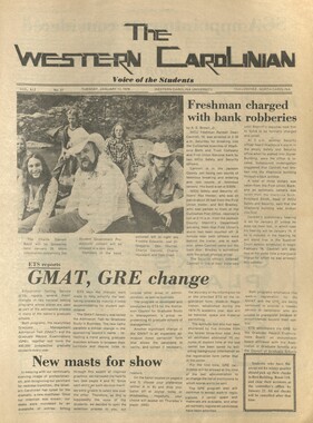
Western Carolinian Volume 59 Number 26

-
Western Carolinian Volume 33 Number 08

-
Western Carolinian Volume 46 Number 12, November 12, 1981
-
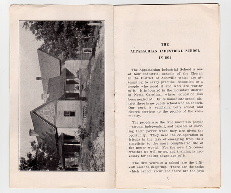
Appalachian Industrial School in the Mountains of North Carolina pages 2 & 3
-
Western Carolinia Volume 46 Number 31

-
Traditional Craftsmanship by Butch and Louise Goings

-
Western Carolinian Volume 49 Number 17

-
Western Carolinian Volume 44 Number 04

-
Nature Magazine: Carolina number
-
Western Carolinian Volume 41 Number 27
-
Western Carolinian Volume 39 Number 64 (62)

-
Western Carolinian Volume 62 Number 10

-
Western Carolinian Volume 45 Number 03

-
Western Carolinian Volume 33 Number 44
-
Constitution and Laws of the Cherokee Nation
-
Western Carolinian Volume 41 Number 16

-
Western Carolinian Volume 34 Number 09

-
Report of the Secretary of Agriculture in relation to the forests, rivers, and mountains of the southern Appalachian region

-
Western Carolinian Volume 63 (64) Number 27

-
Western Carolinian Volume 64 (65) Number 14

-
Western Carolinian Volume 48 Number 24

-
Western Carolinian Volume 58 Summer School Schedule Special Issue
-
Western Carolinian Volume 62 Number 18

-
Western Carolinian Volume 66 (67) Number 07
-
Western Carolinian Volume 65 (66) Number 23 (25)

-
Western Carolinian Volume 46 Number 27
-
Western Carolinian Volume 41 Number 21

-
Western Carolinian Volume 62 (63) Number 14
-
Western Carolinian Volume 63 (64) Number 21

-
Western Carolinian Volume 49 Number 06
-
Mountain Scenery: The Scenery of the Mountains of Western North Carolina and Northwestern South Carolina
-
Western Carolinian Volume 30 Number 01

Part of Collection
Great Smoky Mountains - A Park for America
-
Study for the Preservation of Mountain Culture in Field Museum of History

-
Hiking Club on Cove Mountain

-
Newfound Gap construction
-
Velma Gail Edmondson and Dent Frizzell on Mount Guyot trail

-
Appalachian National Park: Synopsis of work accomplished

-
Cataloochee tract 215: George H. Caldwell

-
Picture News of Recreational America
-
Guide to the Great Smoky Mountains National Park
-
Report of the Secretary of Agriculture in relation to the forests, rivers, and mountains of the southern Appalachian region

-
Appalachian National Park Association Newspaper Clippings, 1899-1902
-
Cataloochee tract 251: James H. Hannah
-
Resolution presented to U.S. Congress

-
Henry Arvel Greene and Jane Patton Greene

-
Civilian Conservation Corps Annual: District "C"

-
Minutes of Meetings of the Appalachian National Park Association
-
Horace Kephart and the Great Smoky Mountains National Park
-
Minutes of Meetings of the Appalachian National Park Association
-
Nomenclature notebook: N.C. portion/ Great Smoky Mountains National Park

-
Cataloochee tract 219: Milia Palmer

-
Paint Rock

-
Nomenclature notes
-
Sourwood
-
Scrapbook by A. H. McQuilkin
-
Minutes of Meetings of the Appalachian National Park Association
-
Financial record of Cash Receipts and Expenditures

-
Siler's Bald from Miry Ridge
-
Mount LeConte via Rainbow Falls

-
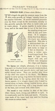
Common forest trees of North Carolina
-
Financial receipts and expenditures, 1899

-
Interviews by Joe Hall about life in Cataloochee

-
McKinney and Miss Campbell at Sinks
-
Hikers at Three Forks
