Western Carolina University (20)
View all
- Canton Champion Fibre Company (2308)
- Cherokee Traditions (293)
- Civil War in Southern Appalachia (165)
- Craft Revival (1942)
- Great Smoky Mountains - A Park for America (2767)
- Highlights from Western Carolina University (430)
- Horace Kephart (941)
- Journeys Through Jackson (154)
- LGBTQIA+ Archive of Jackson County (19)
- Oral Histories of Western North Carolina (314)
- Picturing Appalachia (6679)
- Stories of Mountain Folk (413)
- Travel Western North Carolina (160)
- Western Carolina University Fine Art Museum Vitreograph Collection (129)
- Western Carolina University Herbarium (92)
- Western Carolina University: Making Memories (708)
- Western Carolina University Publications (2283)
- Western Carolina University Restricted Electronic Theses and Dissertations (146)
- Western North Carolina Regional Maps (71)
- World War II in Southern Appalachia (131)
University of North Carolina Asheville (6)
View all
- Appalachian National Park Association (53)
- Berry, Walter (76)
- Champion Fibre Company (5)
- Fromer, Irving Rhodes, 1913-1994 (70)
- Grant, George Alexander, 1891-1964 (96)
- Kephart, Horace, 1862-1931 (23)
- Masa, George, 1881-1933 (17)
- North Carolina Park Commission (105)
- Roth, Albert, 1890-1974 (142)
- Schenck, Carl Alwin, 1868-1955 (1)
- Stearns, I. K. (2)
- Thompson, James Edward, 1880-1976 (45)
- Weaver, Zebulon, 1872-1948 (55)
- Wilburn, Hiram Coleman, 1880-1967 (72)
- Allanstand Cottage Industries (0)
- Bennett, Kelly, 1890-1974 (0)
- Brasstown Carvers (0)
- Cain, Doreyl Ammons (0)
- Carver, George Washington, 1864?-1943 (0)
- Cathey, Joseph, 1803-1874 (0)
- Champion Paper and Fibre Company (0)
- Cherokee Indian Fair Association (0)
- Cherokee Language Program (0)
- Crittenden, Lorraine (0)
- Crowe, Amanda (0)
- Edmonston, Thomas Benton, 1842-1907 (0)
- Ensley, A. L. (Abraham Lincoln), 1865-1948 (0)
- George Butz (BFS 1907) (0)
- Goodrich, Frances Louisa (0)
- Heard, Marian Gladys (0)
- Kephart, Calvin, 1883-1969 (0)
- Kephart, Laura, 1862-1954 (0)
- Laney, Gideon Thomas, 1889-1976 (0)
- McElhinney, William Julian, 1896-1953 (0)
- Niggli, Josephina, 1910-1983 (0)
- Osborne, Kezia Stradley (0)
- Owens, Samuel Robert, 1918-1995 (0)
- Penland Weavers and Potters (0)
- Rhodes, Judy (0)
- Roberts, Vivienne (0)
- Sherrill's Photography Studio (0)
- Smith, Edward Clark (0)
- Southern Highland Handicraft Guild (0)
- Southern Highlanders, Inc. (0)
- Stalcup, Jesse Bryson (0)
- United States. Indian Arts and Crafts Board (0)
- USFS (0)
- Vance, Zebulon Baird, 1830-1894 (0)
- Western Carolina College (0)
- Western Carolina Teachers College (0)
- Western Carolina University (0)
- Western Carolina University. Mountain Heritage Center (0)
- Whitman, Walt, 1819-1892 (0)
- Williams, Isadora (0)
- 1810s (1)
- 1840s (1)
- 1850s (2)
- 1860s (3)
- 1870s (4)
- 1880s (7)
- 1890s (64)
- 1900s (294)
- 1910s (227)
- 1920s (461)
- 1930s (1585)
- 1940s (82)
- 1950s (15)
- 1960s (13)
- 1970s (47)
- 1980s (14)
- 1990s (17)
- 2000s (31)
- 2010s (1)
- 1600s (0)
- 1700s (0)
- 1800s (0)
- 1820s (0)
- 1830s (0)
- 2020s (0)
- Appalachian Region, Southern (80)
- Asheville (N.C.) (1)
- Avery County (N.C.) (6)
- Blount County (Tenn.) (159)
- Buncombe County (N.C.) (204)
- Cherokee County (N.C.) (10)
- Clay County (N.C.) (3)
- Graham County (N.C.) (108)
- Great Smoky Mountains National Park (N.C. and Tenn.) (416)
- Haywood County (N.C.) (263)
- Henderson County (N.C.) (13)
- Jackson County (N.C.) (58)
- Knox County (Tenn.) (21)
- Knoxville (Tenn.) (11)
- Lake Santeetlah (N.C.) (10)
- Macon County (N.C.) (25)
- Madison County (N.C.) (14)
- McDowell County (N.C.) (5)
- Mitchell County (N.C.) (7)
- Polk County (N.C.) (2)
- Qualla Boundary (22)
- Rutherford County (N.C.) (16)
- Swain County (N.C.) (516)
- Transylvania County (N.C.) (36)
- Watauga County (N.C.) (2)
- Waynesville (N.C.) (2)
- Yancey County (N.C.) (34)
- Aerial Views (3)
- Articles (1)
- Artifacts (object Genre) (4)
- Clippings (information Artifacts) (77)
- Drawings (visual Works) (174)
- Envelopes (2)
- Financial Records (9)
- Fliers (printed Matter) (34)
- Guidebooks (1)
- Interviews (11)
- Land Surveys (102)
- Letters (correspondence) (219)
- Manuscripts (documents) (91)
- Maps (documents) (69)
- Memorandums (14)
- Minutes (administrative Records) (20)
- Negatives (photographs) (282)
- Newsletters (12)
- Paintings (visual Works) (1)
- Pen And Ink Drawings (1)
- Photographs (1657)
- Portraits (39)
- Postcards (15)
- Publications (documents) (107)
- Scrapbooks (3)
- Sound Recordings (7)
- Speeches (documents) (11)
- Transcripts (46)
- Aerial Photographs (0)
- Albums (books) (0)
- Biography (general Genre) (0)
- Cards (information Artifacts) (0)
- Crafts (art Genres) (0)
- Depictions (visual Works) (0)
- Design Drawings (0)
- Facsimiles (reproductions) (0)
- Fiction (general Genre) (0)
- Glass Plate Negatives (0)
- Internegatives (0)
- Newspapers (0)
- Occupation Currency (0)
- Periodicals (0)
- Personal Narratives (0)
- Plans (maps) (0)
- Poetry (0)
- Programs (documents) (0)
- Questionnaires (0)
- Sheet Music (0)
- Slides (photographs) (0)
- Specimens (0)
- Text Messages (0)
- Tintypes (photographs) (0)
- Video Recordings (physical Artifacts) (0)
- Vitreographs (0)
- Appalachian National Park Association Records (336)
- Carlos C. Campbell Collection (282)
- Cataloochee History Project (65)
- George Masa Collection (89)
- Hiram C. Wilburn Papers (28)
- Historic Photographs Collection (236)
- Horace Kephart Collection (126)
- Humbard Collection (33)
- Jim Thompson Collection (44)
- Love Family Papers (11)
- Map Collection (12)
- R.A. Romanes Collection (10)
- Smoky Mountains Hiking Club Collection (616)
- Zebulon Weaver Collection (107)
- A.L. Ensley Collection (0)
- Appalachian Industrial School Records (0)
- Axley-Meroney Collection (0)
- Bayard Wootten Photograph Collection (0)
- Bethel Rural Community Organization Collection (0)
- Blumer Collection (0)
- C.W. Slagle Collection (0)
- Canton Area Historical Museum (0)
- Cherokee Studies Collection (0)
- Daisy Dame Photograph Album (0)
- Daniel Boone VI Collection (0)
- Doris Ulmann Photograph Collection (0)
- Elizabeth H. Lasley Collection (0)
- Elizabeth Woolworth Szold Fleharty Collection (0)
- Frank Fry Collection (0)
- Gideon Laney Collection (0)
- Hazel Scarborough Collection (0)
- Hunter and Weaver Families Collection (0)
- I. D. Blumenthal Collection (0)
- Isadora Williams Collection (0)
- Jesse Bryson Stalcup Collection (0)
- John B. Battle Collection (0)
- John C. Campbell Folk School Records (0)
- John Parris Collection (0)
- Judaculla Rock project (0)
- Kelly Bennett Collection (0)
- Major Wiley Parris Civil War Letters (0)
- McFee-Misemer Civil War Letters (0)
- Mountain Heritage Center Collection (0)
- Norburn - Robertson - Thomson Families Collection (0)
- Pauline Hood Collection (0)
- Pre-Guild Collection (0)
- Qualla Arts and Crafts Mutual Collection (0)
- Rosser H. Taylor Collection (0)
- Samuel Robert Owens Collection (0)
- Sara Madison Collection (0)
- Sherrill Studio Photo Collection (0)
- Stories of Mountain Folk - Radio Programs (0)
- The Reporter, Western Carolina University (0)
- Venoy and Elizabeth Reed Collection (0)
- WCU Gender and Sexuality Oral History Project (0)
- WCU Mountain Heritage Center Oral Histories (0)
- WCU Oral History Collection - Mountain People, Mountain Lives (0)
- WCU Students Newspapers Collection (0)
- Western North Carolina Tomorrow Black Oral History Project (0)
- William Williams Stringfield Collection (0)
- Appalachian Trail (22)
- Church buildings (9)
- Civilian Conservation Corps (U.S.) (91)
- Dams (21)
- Floods (1)
- Forest conservation (11)
- Forests and forestry (42)
- Great Smoky Mountains National Park (N.C. and Tenn.) (64)
- Hunting (2)
- Logging (25)
- Maps (74)
- North Carolina -- Maps (5)
- Postcards (15)
- Railroad trains (8)
- Sports (4)
- Storytelling (2)
- Waterfalls -- Great Smoky Mountains (N.C. and Tenn.) (39)
- African Americans (0)
- Artisans (0)
- Cherokee art (0)
- Cherokee artists -- North Carolina (0)
- Cherokee language (0)
- Cherokee pottery (0)
- Cherokee women (0)
- College student newspapers and periodicals (0)
- Dance (0)
- Education (0)
- Folk music (0)
- Forced removal, 1813-1903 (0)
- Gender nonconformity (0)
- Landscape photography (0)
- Mines and mineral resources (0)
- Paper industry (0)
- Pottery (0)
- Rural electrification -- North Carolina, Western (0)
- School integration -- Southern States (0)
- Segregation -- North Carolina, Western (0)
- Slavery (0)
- Weaving -- Appalachian Region, Southern (0)
- Wood-carving -- Appalachian Region, Southern (0)
- World War, 1939-1945 (0)
- Sound (7)
- StillImage (2172)
- Text (655)
- MovingImage (0)
Nomenclature notes
Nomenclature notes
GSMNP_13150_31_05
Item
Item’s are ‘child’ level descriptions to ‘parent’ objects, (e.g. one page of a whole book).
-
-
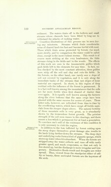
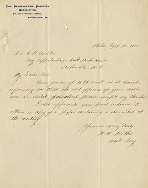
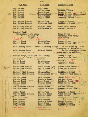
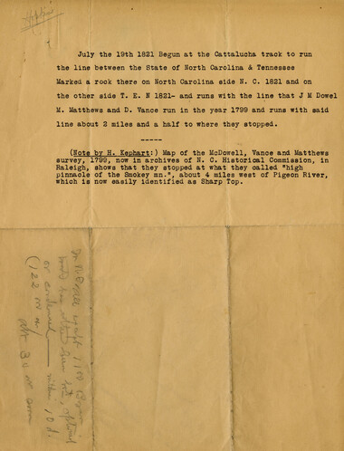
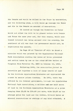
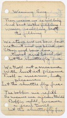
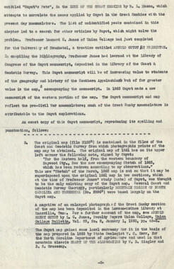
At the time of the removal of the Cherokees the War Department directed Philip Harry to map a part of the Cherokee territory. Harry’s map, of excellent topography for the time, is dated 1837-38. It was never published, but the origi- nal is in the library of the Chief of Engineers, U. S. A., Wash- ington. It does not include the Smokies; but on one margin is the legend “Great Iron or Smoky Mountains.” It should be understood that very few whites lived in the Great Smoky Mountains until about the time of the Civil War, and that to this day a large part of the area is quite un- inhabited. The first really scientific exploration of this region was made in 1861 by Porf. Arnold Guyot, of Princeton College, N. J.. Rather amateurish attempts had previously been made by Clingman and Buckley; but the results were inconclusive. Guy- ot called the range, extending from the Big Pigeon to the Little Tennessee rivers, the Great Smoky Mountains. This has been its official and local designation ever since he mapped it. There is need of a general term to include the whole north- western escarpment of the Southern Appalachians from the Vir- ginia to the Georgia lines, forming the boundary between North Carolina and Tennessee. This particularly to distinguish it from the more of less parallel Blue Ridge that front on the Pied- mont, and from the transverse ranges connecting them. The massive all of mountains fronting toward Tennessee and the Great Appalachian Valley has, indeed, for convenience sake, been commonly called by geographers of our time the Unakas. But it is cut into segments by rivers flowing westward; each seg- ment (with one exception, soon to be noted) has a name of its own; and the embarrassing point is that two of these segments are alike named Unaka. It seems to me that the best way out of the difficulty is to adopt the geographers’ practice, call the whole system Unaka, and give new names to the short segments that at present bear that designation. Confusion would thus be avoided. There is, however, one segment, that bears no name, of- ficial or local, that is commonly accepted. This is the one from the French Broad to the Little Pigeon rivers. In western North Carolina we generally refer to it as the Max Patch section, after the name of its principal peak. Certain parties interested in real estate projects have lately been including it, in their literature, with the Great Smoky Mountains; doubtless for interested reasons, owing the proximity of the Great Smoky Mountains National Park. But with equal logic it might be attached to the Bald Mountains on the other side of the French Broad. This segment certainly should have a name; but I have no suggestion to make as to its nomenclature. Very sincerely, (signed) Horace Kephart.
Object
Object’s are ‘parent’ level descriptions to ‘children’ items, (e.g. a book with pages).
-
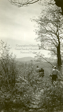
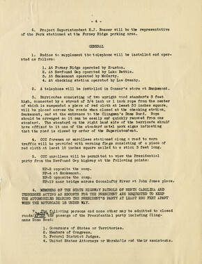
These notes on place names in the Smokies were made by Horace Kephart and were collected by George Masa. George Masa (1881-1933) was active in the Appalachian Trail Club and in the movement to establish the Great Smoky Mountains National Park. In 1931, he was named to the three-person nomenclature committee for the North Carolina Park Commission and had the responsibility for accurately naming the peaks, streams, and other features. Mutual interests fostered Masa’s friendship with Horace Kephart (1862-1931), a noted author and promoter of the Great Smoky Mountains National Park. Kephart and Masa often hiked together with park officials on inspection trips and provided information to stir public interest. Kephart wrote many articles promoting regional conservation and the park movement.
-


Part of Collection
Great Smoky Mountains - A Park for America