Western Carolina University (20)
View all
- Canton Champion Fibre Company (2308)
- Cherokee Traditions (292)
- Civil War in Southern Appalachia (165)
- Craft Revival (1942)
- Great Smoky Mountains - A Park for America (2766)
- Highlights from Western Carolina University (430)
- Horace Kephart (941)
- Journeys Through Jackson (154)
- LGBTQIA+ Archive of Jackson County (85)
- Oral Histories of Western North Carolina (314)
- Picturing Appalachia (6772)
- Stories of Mountain Folk (413)
- Travel Western North Carolina (160)
- Western Carolina University Fine Art Museum Vitreograph Collection (129)
- Western Carolina University Herbarium (92)
- Western Carolina University: Making Memories (708)
- Western Carolina University Publications (2283)
- Western Carolina University Restricted Electronic Theses and Dissertations (146)
- Western North Carolina Regional Maps (71)
- World War II in Southern Appalachia (131)
University of North Carolina Asheville (6)
View all
- Appalachian National Park Association (53)
- Berry, Walter (76)
- Champion Fibre Company (5)
- Fromer, Irving Rhodes, 1913-1994 (70)
- Grant, George Alexander, 1891-1964 (96)
- Kephart, Horace, 1862-1931 (23)
- Masa, George, 1881-1933 (17)
- North Carolina Park Commission (105)
- Roth, Albert, 1890-1974 (142)
- Schenck, Carl Alwin, 1868-1955 (1)
- Stearns, I. K. (2)
- Thompson, James Edward, 1880-1976 (45)
- Weaver, Zebulon, 1872-1948 (55)
- Wilburn, Hiram Coleman, 1880-1967 (72)
- Allanstand Cottage Industries (0)
- Bennett, Kelly, 1890-1974 (0)
- Brasstown Carvers (0)
- Cain, Doreyl Ammons (0)
- Carver, George Washington, 1864?-1943 (0)
- Cathey, Joseph, 1803-1874 (0)
- Champion Paper and Fibre Company (0)
- Cherokee Indian Fair Association (0)
- Cherokee Language Program (0)
- Crittenden, Lorraine (0)
- Crowe, Amanda (0)
- Edmonston, Thomas Benton, 1842-1907 (0)
- Ensley, A. L. (Abraham Lincoln), 1865-1948 (0)
- George Butz (BFS 1907) (0)
- Goodrich, Frances Louisa (0)
- Heard, Marian Gladys (0)
- Kephart, Calvin, 1883-1969 (0)
- Kephart, Laura, 1862-1954 (0)
- Laney, Gideon Thomas, 1889-1976 (0)
- McElhinney, William Julian, 1896-1953 (0)
- Niggli, Josephina, 1910-1983 (0)
- Osborne, Kezia Stradley (0)
- Owens, Samuel Robert, 1918-1995 (0)
- Penland Weavers and Potters (0)
- Rhodes, Judy (0)
- Roberts, Vivienne (0)
- Sherrill's Photography Studio (0)
- Smith, Edward Clark (0)
- Southern Highland Handicraft Guild (0)
- Southern Highlanders, Inc. (0)
- Stalcup, Jesse Bryson (0)
- United States. Indian Arts and Crafts Board (0)
- USFS (0)
- Vance, Zebulon Baird, 1830-1894 (0)
- Western Carolina College (0)
- Western Carolina Teachers College (0)
- Western Carolina University (0)
- Western Carolina University. Mountain Heritage Center (0)
- Whitman, Walt, 1819-1892 (0)
- Williams, Isadora (0)
- 1810s (1)
- 1840s (1)
- 1850s (2)
- 1860s (3)
- 1870s (4)
- 1880s (7)
- 1890s (64)
- 1900s (294)
- 1910s (227)
- 1920s (461)
- 1930s (1585)
- 1940s (82)
- 1950s (15)
- 1960s (13)
- 1970s (47)
- 1980s (14)
- 1990s (16)
- 2000s (31)
- 2010s (1)
- 1600s (0)
- 1700s (0)
- 1800s (0)
- 1820s (0)
- 1830s (0)
- 2020s (0)
- Appalachian Region, Southern (81)
- Asheville (N.C.) (3)
- Avery County (N.C.) (6)
- Blount County (Tenn.) (159)
- Buncombe County (N.C.) (204)
- Cherokee County (N.C.) (10)
- Clay County (N.C.) (3)
- Graham County (N.C.) (108)
- Great Smoky Mountains National Park (N.C. and Tenn.) (447)
- Haywood County (N.C.) (262)
- Henderson County (N.C.) (13)
- Jackson County (N.C.) (58)
- Knox County (Tenn.) (21)
- Knoxville (Tenn.) (11)
- Lake Santeetlah (N.C.) (10)
- Macon County (N.C.) (25)
- Madison County (N.C.) (14)
- McDowell County (N.C.) (5)
- Mitchell County (N.C.) (7)
- Polk County (N.C.) (2)
- Qualla Boundary (22)
- Rutherford County (N.C.) (16)
- Swain County (N.C.) (516)
- Transylvania County (N.C.) (36)
- Watauga County (N.C.) (2)
- Waynesville (N.C.) (2)
- Yancey County (N.C.) (34)
- Aerial Views (3)
- Articles (1)
- Artifacts (object Genre) (4)
- Bibliographies (1)
- Clippings (information Artifacts) (77)
- Drawings (visual Works) (174)
- Envelopes (2)
- Financial Records (9)
- Fliers (printed Matter) (34)
- Guidebooks (1)
- Interviews (15)
- Land Surveys (102)
- Letters (correspondence) (219)
- Manuscripts (documents) (90)
- Maps (documents) (86)
- Memorandums (14)
- Minutes (administrative Records) (20)
- Negatives (photographs) (282)
- Newsletters (12)
- Paintings (visual Works) (1)
- Pen And Ink Drawings (1)
- Photographs (1657)
- Portraits (91)
- Postcards (15)
- Publications (documents) (107)
- Scrapbooks (3)
- Sheet Music (1)
- Songs (musical Compositions) (2)
- Sound Recordings (7)
- Speeches (documents) (11)
- Transcripts (46)
- Aerial Photographs (0)
- Albums (books) (0)
- Biography (general Genre) (0)
- Cards (information Artifacts) (0)
- Crafts (art Genres) (0)
- Depictions (visual Works) (0)
- Design Drawings (0)
- Facsimiles (reproductions) (0)
- Fiction (general Genre) (0)
- Glass Plate Negatives (0)
- Internegatives (0)
- Newspapers (0)
- Occupation Currency (0)
- Periodicals (0)
- Personal Narratives (0)
- Plans (maps) (0)
- Poetry (0)
- Programs (documents) (0)
- Questionnaires (0)
- Slides (photographs) (0)
- Specimens (0)
- Text Messages (0)
- Tintypes (photographs) (0)
- Video Recordings (physical Artifacts) (0)
- Vitreographs (0)
- Appalachian National Park Association Records (336)
- Carlos C. Campbell Collection (282)
- Cataloochee History Project (64)
- George Masa Collection (89)
- Hiram C. Wilburn Papers (28)
- Historic Photographs Collection (236)
- Horace Kephart Collection (126)
- Humbard Collection (33)
- Jim Thompson Collection (44)
- Love Family Papers (11)
- Map Collection (12)
- R.A. Romanes Collection (10)
- Smoky Mountains Hiking Club Collection (616)
- Zebulon Weaver Collection (107)
- A.L. Ensley Collection (0)
- Appalachian Industrial School Records (0)
- Axley-Meroney Collection (0)
- Bayard Wootten Photograph Collection (0)
- Bethel Rural Community Organization Collection (0)
- Blumer Collection (0)
- C.W. Slagle Collection (0)
- Canton Area Historical Museum (0)
- Cherokee Studies Collection (0)
- Daisy Dame Photograph Album (0)
- Daniel Boone VI Collection (0)
- Doris Ulmann Photograph Collection (0)
- Elizabeth H. Lasley Collection (0)
- Elizabeth Woolworth Szold Fleharty Collection (0)
- Frank Fry Collection (0)
- Gideon Laney Collection (0)
- Hazel Scarborough Collection (0)
- Hunter and Weaver Families Collection (0)
- I. D. Blumenthal Collection (0)
- Isadora Williams Collection (0)
- Jesse Bryson Stalcup Collection (0)
- John B. Battle Collection (0)
- John C. Campbell Folk School Records (0)
- John Parris Collection (0)
- Judaculla Rock project (0)
- Kelly Bennett Collection (0)
- Major Wiley Parris Civil War Letters (0)
- McFee-Misemer Civil War Letters (0)
- Mountain Heritage Center Collection (0)
- Norburn - Robertson - Thomson Families Collection (0)
- Pauline Hood Collection (0)
- Pre-Guild Collection (0)
- Qualla Arts and Crafts Mutual Collection (0)
- Rosser H. Taylor Collection (0)
- Samuel Robert Owens Collection (0)
- Sara Madison Collection (0)
- Sherrill Studio Photo Collection (0)
- Stories of Mountain Folk - Radio Programs (0)
- The Reporter, Western Carolina University (0)
- Venoy and Elizabeth Reed Collection (0)
- WCU Gender and Sexuality Oral History Project (0)
- WCU Mountain Heritage Center Oral Histories (0)
- WCU Oral History Collection - Mountain People, Mountain Lives (0)
- WCU Students Newspapers Collection (0)
- Western North Carolina Tomorrow Black Oral History Project (0)
- William Williams Stringfield Collection (0)
- Appalachian Trail (22)
- Church buildings (9)
- Civilian Conservation Corps (U.S.) (91)
- Dams (21)
- Floods (1)
- Forest conservation (11)
- Forests and forestry (42)
- Great Smoky Mountains National Park (N.C. and Tenn.) (82)
- Hunting (2)
- Logging (29)
- Maps (73)
- North Carolina -- Maps (5)
- Postcards (15)
- Railroad trains (8)
- Sports (4)
- Storytelling (2)
- Waterfalls -- Great Smoky Mountains (N.C. and Tenn.) (39)
- African Americans (0)
- Artisans (0)
- Cherokee art (0)
- Cherokee artists -- North Carolina (0)
- Cherokee language (0)
- Cherokee pottery (0)
- Cherokee women (0)
- College student newspapers and periodicals (0)
- Dance (0)
- Education (0)
- Folk music (0)
- Forced removal, 1813-1903 (0)
- Gender nonconformity (0)
- Landscape photography (0)
- Mines and mineral resources (0)
- Paper industry (0)
- Pottery (0)
- Rural electrification -- North Carolina, Western (0)
- School integration -- Southern States (0)
- Segregation -- North Carolina, Western (0)
- Slavery (0)
- Weaving -- Appalachian Region, Southern (0)
- Wood-carving -- Appalachian Region, Southern (0)
- World War, 1939-1945 (0)
- Sound (7)
- StillImage (2172)
- Text (654)
- MovingImage (0)
Discrepencies as appear on the Park Map in Tennessee
Item 1 - Discrepencies as appear on the Park Map in Tennessee

Discrepencies as appear on the Park Map in Tennessee
GSMNP_10184_11_01
Discrepencies as appear on the Park Map in Tennessee
GSMNP_10184_11_02
Item
Item’s are ‘child’ level descriptions to ‘parent’ objects, (e.g. one page of a whole book).
-
-
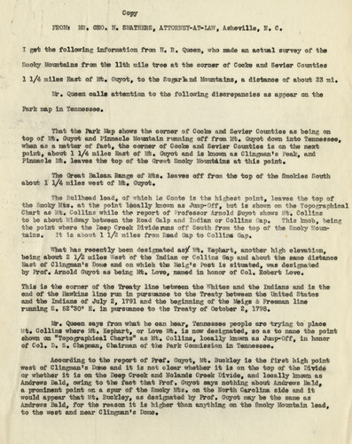
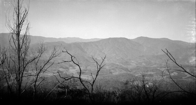
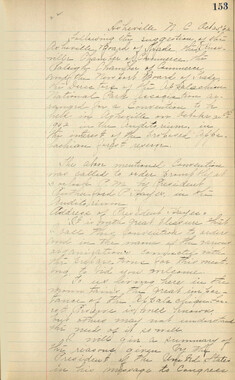
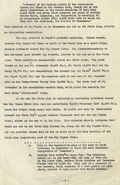
Copy FROMi MS., GEO. H, SHaSHStS, ATTORV' !Y-AT-U , Ashevillo, ■« 8. I get the following information from H. R. Queen, who made as actual survey of the Smoky Mountains from the 11th mile tree at the corner of Cocke aad Sevier Counties 1 1/4 miles East of Mt* Guyot, to the Sugarknd Mountains, a distance of about 23 ml. Mr* Queen calls attention to the following discrepancies as appear on the Park map in Tennessee. That the Park Map shows the comer of Cocke and Sevier Counties as being on top of Mt, Guyot and Pinnacle Mountain running off from It. Guyot down into Tennessee, when as a matter of fact, the corner of Cocke and Sevier Counties is on the next point,-about 1 1/4 miles East of Mt, Guyot and is known as Cliapian's Peak, and Pinnacle Mt* leaves the top of the Great Smoky Mountains at this point. The Great Balsam Range of Its. leaves off from the top of the Smokies South about 1 l/4 miles west of Mt, Guyot, ullhead lead, of which L© Conte is the highest point, ' m ess - feOf of the Smoky Mis. at the point locally known as Jump-Off, but is shown on the Top-. Chart as ttt* Collins while the report of i-rofeesor Arnold guyet shows "t. Collins to he about icferay between the Road Galp and Indian or Collins rap« This knob, being the point where the Eeep Creek Divide rune off South from the top of the Smoky Mountains. It is about 1 l/2 miles from Read Gap to Collins Gap. What has recently been designated ae^" it. Kephart, another high elevation, being about 2 l/2 miles !£eei of the Indian or Collins Gap and about the same distance East of Ciing»an*s Borne and on which ths lleig's Post is situated, was designated by Prof. Arnold Gt^ot as being lit;. Love, named in honor of Col. Robert Love, This is the corner of the Treaty line between the Whites and the Indians and is the end of the Hawkins -line run in pursuance to the Treaty between the United States and the Indians of July 2, 1791 and the beginning of the Meigs 4 Freeman line running S. 52o50* E. la pursuance to the Treaty of October 2, 1798. Mr* Queen says from what he can hear, Tennessee people ar© trying to place "Mt* Collins where Mt* Kephart, or Love Mt, is now designated, so as to name the point shown on "Topographical Charts" as Mt. Collins, locally known as Jump-Off, in honor of Col. 1>. S, Chapman, Chairman of the Park Commission in Tennessee. According to the report of Prof* Guyot, Mt. Buckley is the first high point west of Cllagman's Dome and it is not clear whether It is on the top of the livid© or whether it is on the Seep Creek and Nolands Creek Divide, and locally known as Andrews Bald, owing to the fact that Prof. Guyot says nothing about Andrews Bald, a prominent point on a spur of the Smoky Mfcs. on the North Carolina side and it would appear that Mt* Buckley, as designated by Prof. Guyot may he tho saiao as Andrews Bald, for the reason it is higher than anything on the Smoky Mountain lead, to the west and near Clingman's Dome*
Object
Object’s are ‘parent’ level descriptions to ‘children’ items, (e.g. a book with pages).
-
Like many rural areas, names of places within the Great Smoky Mountains were sometimes redundant or known by different names in different localities. In the 1930s, the National Park Service appointed a Nomenclature Committee from North Carolina and one from Tennessee to make recommendations to U.S. Geographic Board which decided upon “official” names for peaks, creeks, and roads. Photographer and park advocate, George Masa served on the North Carolina committee.
-
Related items
-
Appalachian Trail Club bulletin

-
Handbook/ 1932/ Smoky Mountains Hiking Club

-
Guide to the Great Smoky Mountains National Park

-
Guide to the Great Smoky Mountains National Park

-
Andrews Bald

-
Horace Kephart Journal 21 Table of Contents

-
Horace Kephart Journal 21

-
Horace Kephart Journal 09 Table of Contents

-
Horace Kephart Journal 08

-
Horace Kephart Journal 13 Table of Contents

-
Horace Kephart Journal 19 Table of Contents

-
View from Clingmans Dome

-
Horace Kephart Journal 24 Table of Contents

-
Possibly Toms Branch Falls hole

-
Horace Kephart Journal 12

-
Henry Arvel Greene and Jane Patton Greene

-
Horace Kephart Journal 03

-
Horace Kephart Journal 05

-
Horace Kephart Journal 14

-
Great Smoky National Park:Travel Index

-
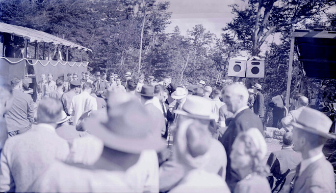
Great Smoky Mountains National Park dedication ceremony
-
Little Tennessee River from State Highway Number 288

-
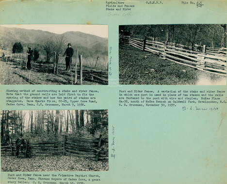
Fields and fences, Cataloochee, N.C.
-
Great Smoky Mountains
-
Horace Kephart Journal 01 Table of Contents

-
Horace Kephart Journal 01

-
Kelly Bennett and friends in Deep Creek

-
Horace Kephart Journal 08 Table of Contents

-
Horace Kephart Journal 17

-
Bryson Place

Part of Collection
Great Smoky Mountains - A Park for America
-
Correspondence between Zebulon Weaver, Fred L. Weede, W. H. Woodbury, David C. Chapman, Mark Squires, Junius G. Adams, March 1932
-
Reasons in Favor of the Establishment of a National Park

-
Appalachian National Park Association Newspaper Clippings, 1899-1902

-
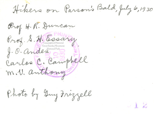
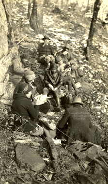
Hikers on Parson Bald
-
Handbook/ 1933/ Smoky Mountains Hiking Club

-
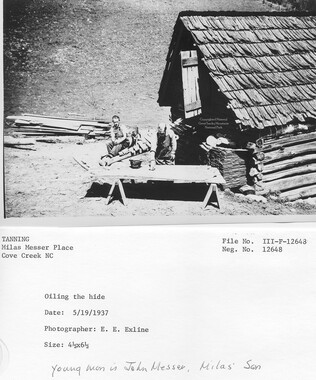
Cataloochee Cove Creek - Milas Messer
-
Minutes of Meetings of the Appalachian National Park Association
-
Handbook/ 1931/ Smoky Mountains Hiking Club

-
Report of the Secretary of Agriculture in relation to the forests, rivers, and mountains of the southern Appalachian region

-
Facts and Figures Concerning the Champion Fibre Company

-
Southern Pictures and Pencillings correspondence

-
Financial receipts and expenditures, 1900

-
Correspondence regarding 1901 meeting
-
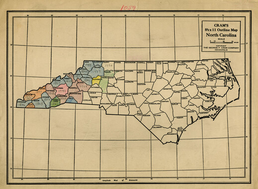
Cram's outline map of North Carolina with annotations
-
Appalachian National Park Association Newspaper Clippings, 1899-1902
-
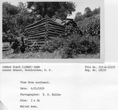
Cataloochee tract 248: J. A. Conrad
-
National Parks Bulletin

-
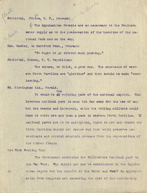
Editorials commenting on the Appalachian National Park movement
-
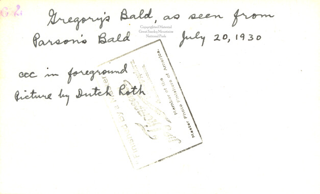
Gregory Bald
-
Yellow Creek Mountain
-
Cataloochee tract 224: Jarvis L. Palmer

-
Appalachian National Park Association Newspaper Clippings, 1902-1907, 1925, 1928

-
Guyot and the Great Smokies
-
Appalachian National Park Association Newspaper Clippings, 1902-1907, 1925, 1928
-
Cataloochee tract 231: W. G. B. Messer
-
Tree on state line
-
Guide to the Great Smoky Mountains National Park

-
Requests for information on Appalachian National Park
-
Cataloochee Cove Creek - Milas Messer
-
Requests for information on Appalachian National Park
-
Program of hikes for 1930/ Smoky Mountains Hiking Club
-
House of Representatives delegate list
