Western Carolina University (20)
View all
- Canton Champion Fibre Company (2308)
- Cherokee Traditions (291)
- Civil War in Southern Appalachia (165)
- Craft Revival (1942)
- Great Smoky Mountains - A Park for America (2946)
- Highlights from Western Carolina University (430)
- Horace Kephart (941)
- Journeys Through Jackson (159)
- LGBTQIA+ Archive of Jackson County (85)
- Oral Histories of Western North Carolina (314)
- Picturing Appalachia (6798)
- Stories of Mountain Folk (413)
- Travel Western North Carolina (160)
- Western Carolina University Fine Art Museum Vitreograph Collection (129)
- Western Carolina University Herbarium (92)
- Western Carolina University: Making Memories (708)
- Western Carolina University Publications (2412)
- Western Carolina University Restricted Electronic Theses and Dissertations (146)
- Western North Carolina Regional Maps (71)
- World War II in Southern Appalachia (131)
University of North Carolina Asheville (6)
View all
- Allanstand Cottage Industries (62)
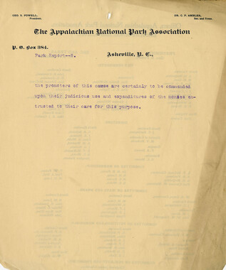
- Appalachian National Park Association (53)
- Bennett, Kelly, 1890-1974 (1388)
- Berry, Walter (76)
- Brasstown Carvers (40)
- Carver, George Washington, 1864?-1943 (26)
- Cathey, Joseph, 1803-1874 (1)
- Champion Fibre Company (233)
- Champion Paper and Fibre Company (297)
- Cherokee Indian Fair Association (16)
- Cherokee Language Program (22)
- Crowe, Amanda (40)
- Edmonston, Thomas Benton, 1842-1907 (7)
- Ensley, A. L. (Abraham Lincoln), 1865-1948 (275)
- Fromer, Irving Rhodes, 1913-1994 (70)
- George Butz (BFS 1907) (46)
- Goodrich, Frances Louisa (120)
- Grant, George Alexander, 1891-1964 (96)
- Heard, Marian Gladys (60)
- Kephart, Calvin, 1883-1969 (15)
- Kephart, Horace, 1862-1931 (313)
- Kephart, Laura, 1862-1954 (39)
- Laney, Gideon Thomas, 1889-1976 (439)
- Masa, George, 1881-1933 (61)
- McElhinney, William Julian, 1896-1953 (44)
- Niggli, Josephina, 1910-1983 (10)
- North Carolina Park Commission (105)
- Osborne, Kezia Stradley (9)
- Owens, Samuel Robert, 1918-1995 (11)
- Penland Weavers and Potters (36)
- Roberts, Vivienne (15)
- Roth, Albert, 1890-1974 (142)
- Schenck, Carl Alwin, 1868-1955 (1)
- Sherrill's Photography Studio (2565)
- Southern Highland Handicraft Guild (127)
- Southern Highlanders, Inc. (71)
- Stalcup, Jesse Bryson (46)
- Stearns, I. K. (213)
- Thompson, James Edward, 1880-1976 (226)
- United States. Indian Arts and Crafts Board (130)
- USFS (683)
- Vance, Zebulon Baird, 1830-1894 (1)
- Weaver, Zebulon, 1872-1948 (58)
- Western Carolina College (230)
- Western Carolina Teachers College (282)
- Western Carolina University (1899)
- Western Carolina University. Mountain Heritage Center (18)
- Whitman, Walt, 1819-1892 (10)
- Wilburn, Hiram Coleman, 1880-1967 (73)
- Williams, Isadora (3)
- Cain, Doreyl Ammons (0)
- Crittenden, Lorraine (0)
- Rhodes, Judy (0)
- Smith, Edward Clark (0)
- Appalachian Region, Southern (2569)
- Asheville (N.C.) (1923)
- Avery County (N.C.) (26)
- Blount County (Tenn.) (195)
- Buncombe County (N.C.) (1672)
- Cherokee County (N.C.) (283)
- Clay County (N.C.) (555)
- Graham County (N.C.) (233)
- Great Smoky Mountains National Park (N.C. and Tenn.) (519)
- Haywood County (N.C.) (3569)
- Henderson County (N.C.) (70)
- Jackson County (N.C.) (4804)
- Knox County (Tenn.) (35)
- Knoxville (Tenn.) (13)
- Lake Santeetlah (N.C.) (10)
- Macon County (N.C.) (420)
- Madison County (N.C.) (215)
- McDowell County (N.C.) (39)
- Mitchell County (N.C.) (132)
- Polk County (N.C.) (35)
- Qualla Boundary (981)
- Rutherford County (N.C.) (76)
- Swain County (N.C.) (2135)
- Transylvania County (N.C.) (270)
- Watauga County (N.C.) (12)
- Waynesville (N.C.) (86)
- Yancey County (N.C.) (72)
- Aerial Photographs (3)
- Aerial Views (60)
- Albums (books) (4)
- Articles (1)
- Artifacts (object Genre) (228)
- Bibliographies (1)
- Biography (general Genre) (2)
- Cards (information Artifacts) (38)
- Clippings (information Artifacts) (191)
- Copybooks (instructional Materials) (3)
- Crafts (art Genres) (622)
- Depictions (visual Works) (21)
- Design Drawings (1)
- Drawings (visual Works) (185)
- Envelopes (73)
- Exhibitions (events) (1)
- Facsimiles (reproductions) (1)
- Fiction (general Genre) (4)
- Financial Records (12)
- Fliers (printed Matter) (67)
- Glass Plate Negatives (381)
- Guidebooks (2)
- Internegatives (10)
- Interviews (815)
- Land Surveys (102)
- Letters (correspondence) (1013)
- Manuscripts (documents) (618)
- Maps (documents) (177)
- Memorandums (25)
- Minutes (administrative Records) (59)
- Negatives (photographs) (6015)
- Newsletters (1290)
- Newspapers (2)
- Notebooks (8)
- Occupation Currency (1)
- Paintings (visual Works) (1)
- Pen And Ink Drawings (1)
- Periodicals (193)
- Personal Narratives (10)
- Photographs (12976)
- Plans (maps) (1)
- Poetry (5)
- Portraits (4539)
- Postcards (329)
- Programs (documents) (151)
- Publications (documents) (2364)
- Questionnaires (65)
- Relief Prints (26)
- Sayings (literary Genre) (1)
- Scrapbooks (282)
- Sheet Music (2)
- Slides (photographs) (402)
- Songs (musical Compositions) (2)
- Sound Recordings (796)
- Specimens (92)
- Speeches (documents) (15)
- Tintypes (photographs) (8)
- Transcripts (322)
- Video Recordings (physical Artifacts) (23)
- Text Messages (0)
- A.L. Ensley Collection (275)
- Appalachian Industrial School Records (7)
- Appalachian National Park Association Records (336)
- Axley-Meroney Collection (2)
- Bayard Wootten Photograph Collection (20)
- Bethel Rural Community Organization Collection (7)
- Blumer Collection (5)
- C.W. Slagle Collection (20)
- Canton Area Historical Museum (2110)
- Carlos C. Campbell Collection (462)
- Cataloochee History Project (64)
- Cherokee Studies Collection (4)
- Daisy Dame Photograph Album (5)
- Daniel Boone VI Collection (1)
- Doris Ulmann Photograph Collection (112)
- Elizabeth H. Lasley Collection (1)
- Elizabeth Woolworth Szold Fleharty Collection (4)
- Frank Fry Collection (95)
- George Masa Collection (173)
- Gideon Laney Collection (452)
- Hazel Scarborough Collection (2)
- Hiram C. Wilburn Papers (28)
- Historic Photographs Collection (236)
- Horace Kephart Collection (861)
- Humbard Collection (33)
- Hunter and Weaver Families Collection (1)
- I. D. Blumenthal Collection (4)
- Isadora Williams Collection (4)
- Jesse Bryson Stalcup Collection (47)
- Jim Thompson Collection (224)
- John B. Battle Collection (7)
- John C. Campbell Folk School Records (80)
- John Parris Collection (6)
- Judaculla Rock project (2)
- Kelly Bennett Collection (1407)
- Love Family Papers (11)
- Major Wiley Parris Civil War Letters (3)
- Map Collection (12)
- McFee-Misemer Civil War Letters (34)
- Mountain Heritage Center Collection (4)
- Norburn - Robertson - Thomson Families Collection (44)
- Pauline Hood Collection (7)
- Pre-Guild Collection (2)
- Qualla Arts and Crafts Mutual Collection (12)
- R.A. Romanes Collection (681)
- Rosser H. Taylor Collection (1)
- Samuel Robert Owens Collection (94)
- Sara Madison Collection (144)
- Sherrill Studio Photo Collection (2558)
- Smoky Mountains Hiking Club Collection (616)
- Stories of Mountain Folk - Radio Programs (374)
- The Reporter, Western Carolina University (510)
- Venoy and Elizabeth Reed Collection (16)
- WCU Gender and Sexuality Oral History Project (32)
- WCU Mountain Heritage Center Oral Histories (25)
- WCU Oral History Collection - Mountain People, Mountain Lives (71)
- WCU Students Newspapers Collection (1843)
- Western North Carolina Tomorrow Black Oral History Project (69)
- William Williams Stringfield Collection (2)
- Zebulon Weaver Collection (109)
- African Americans (390)
- Appalachian Trail (35)
- Artisans (521)
- Cherokee art (84)
- Cherokee artists -- North Carolina (10)
- Cherokee language (21)
- Cherokee pottery (101)
- Cherokee women (208)
- Church buildings (172)
- Civilian Conservation Corps (U.S.) (111)
- College student newspapers and periodicals (1933)
- Dams (107)
- Dance (1023)
- Education (222)
- Floods (61)
- Folk music (1015)
- Forced removal, 1813-1903 (2)
- Forest conservation (220)
- Forests and forestry (1184)
- Gender nonconformity (4)
- Great Smoky Mountains National Park (N.C. and Tenn.) (181)
- Hunting (45)
- Landscape photography (25)
- Logging (119)
- Maps (83)
- Mines and mineral resources (8)
- North Carolina -- Maps (18)
- Paper industry (38)
- Postcards (255)
- Pottery (135)
- Railroad trains (72)
- Rural electrification -- North Carolina, Western (3)
- School integration -- Southern States (2)
- Segregation -- North Carolina, Western (5)
- Slavery (5)
- Sports (452)
- Storytelling (243)
- Waterfalls -- Great Smoky Mountains (N.C. and Tenn.) (66)
- Weaving -- Appalachian Region, Southern (280)
- Wood-carving -- Appalachian Region, Southern (328)
- World War, 1939-1945 (173)
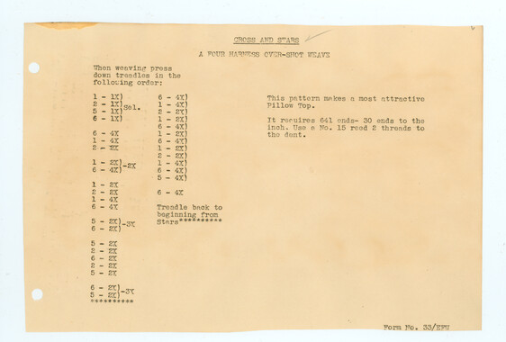
Unaka and the Pisgah


Unaka and the Pisgah
GSMNP_13150_13_01_1098_11
Item
Item’s are ‘child’ level descriptions to ‘parent’ objects, (e.g. one page of a whole book).
-
-
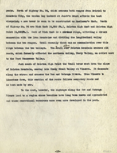
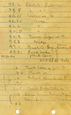
the boundary between Tennessee and North Carolina and roughly paralleling the Iron and Holston ranges. Guyot regarded the Stone Mountains as the true continuous, western rim and devoted his attention to them. Beyond this fork, on both the Guyot map and Lindenkohl chart, the Iron Mountains are only vaguely indicated. By reason of a continuous Forest Service trail and other advantages in route, the northern arm or true Iron Mountains were selected as the route of the Appalachian Trail. No trip to the Unaka section should, however, omit Mt. Rogers or Whitetop. They are quite accessible by trail; roads, either from Skull’s Gap or Damascus, are passable by automobile nearly to their summits. Hithertofore it has been Point Lookout and Buck Mountain, two isolated peaks to the south; but from now on it is Mt. Rogers and Whitetop which dominate the region. Rising 2,000 ft. higher and separated only by a narrow valley, their ever-changing vistas greatly retard the progress of the through traveler. The impression is indelible. The forest growth in the section form U.S. Highway No. 12 to Skull’s Gap is the best yet encountered; a splendid Forest Service trail leads through it. From Skull’s Gap to Damascus the range is known as Grosses Mountain. It reaches its culmination at the Forest Service lookout on Feathercamp Mountain; to the south is a bewildering sea of peaks, typical of the Southern Appalachians; and to the north across the Shenandoah Valley are the rampart walls of the Alleghanies, known to the Indians as the “Endless Mountains”. From Feathercamp lookout a Forest Service trail descends to Damascus. Here Laurel Creek, on its way to join the Holston River, crosses the Iron Mountain. The range, which from New River has trended only slightly south of west, now resumes its north and south course. The break in the range, in which Damascus is picturesquely located, brought with it a new problem in trail location. Instead of one range, two rise abruptly from the south side of -11-
Object
Object’s are ‘parent’ level descriptions to ‘children’ items, (e.g. a book with pages).
-
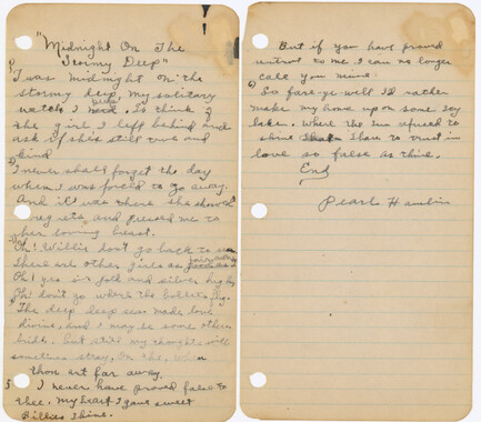
This undated manuscript titled, “The Unaka and the Pisgah,” is by Myron Haliburton Avery (1899–1952), who was president of the Potomac Appalachian Trail Club and chairman of the board of the Appalachian Trail Conference. The paper discusses the Unaka Range and Pisgah Forest and the history of each region. The manuscript was collected by George Masa. Known for his photography, George Masa (1881-1933) was active in the Appalachian Trail Club and in the movement to establish the Great Smoky Mountains National Park.
-
Related items
-
Activities of the Appalachian National Park Association and the Appalachian National Forest Reserve Association: 1899-1906

-
William Twaddell copybook, 1761-1762

-
William Twaddell copybook, 1761-1762

-
Origin of place names in the Great Smoky Mountains

-
Woven cloth sample notebook
-
Tennessee Valley Authority memorandum on mountain handicraft industries
-
Activities of the Appalachian National Park Association and the Appalachian National Forest Reserve Association: 1899-1906
-
Anderson Copy Book
-
William Twaddell copybook, 1761-1762

-
Nomenclature notes: place names in N. C.

-
Horace Kephart and the Great Smoky Mountains National Park

-
Cherokee glossary

-
Nomenclature notes: place names in Smokies

-
Hiking itineraries and notes
-
Anderson Copy Book
-
William Twaddell copybook, 1761-1762

-
Camping and Woodcraft Notes Index - e to gc

-
CCC Sketches Showing Work Done

-
Isadora Williams Weaving Notebook I
-
Horace Kephart Journal 14

-
William Twaddell Copybook, 1758

-
Songs Written By from "The Spinning Wheel" Girls
-
Civil War Diary of Absalom Joshua Burum
-
Weaving Institute, 1936

-
William Twaddell copybook, 1761-1762
-
William Twaddell copybook, 1761-1762
-
William Twaddell Copybook, 1758
-
Activities of the Appalachian National Park Association and the Appalachian National Forest Reserve Association: 1899-1906
Part of Collection
Great Smoky Mountains - A Park for America
-
Glimpses of the Plant of the Champion Fibre Co., Canton, North Carolina
-
Appalachian Trail in the Unaka and the Pisgah National Forests

-
Legislation on behalf of the Appalachian National Park

-
Subscriptions received by the Appalachian National Park Association

-
Letters supporting Appalachian National Park movement
-
Why Should We Study Forestry?
-
Appalachian Trail in winter
-
Travel to Washington D.C.
-
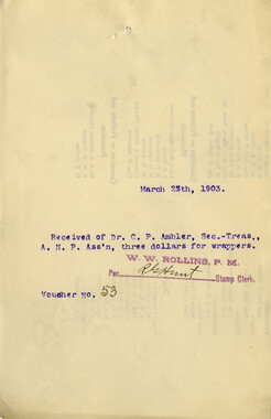
Financial receipts and expenditures, 1903
-
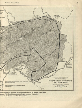
National Parks Bulletin, 1925
-
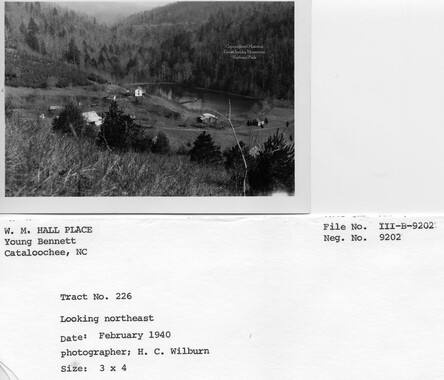
Cataloochee tract 226: W. M. Hall
-
Cataloochee tract 230: Ola Baptist Church Lot

-
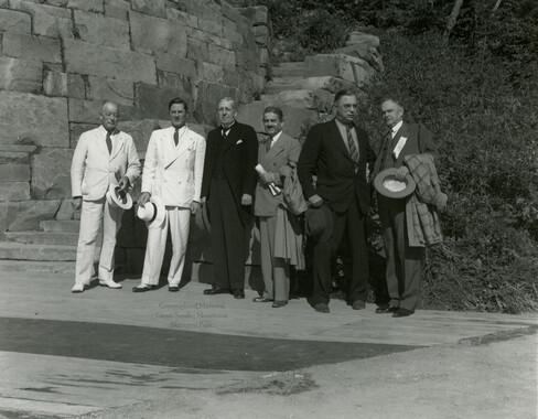
Park dedication: delegates
-
Trip into the Smokies with Horace Kephart

-
Nomenclature notebook: N.C. portion/ Great Smoky Mountains National Park

-
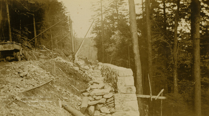
Skyway construction: retaining wall
-
Complete Report Submitted to Governor Clyde R. Hoey
-
Cataloochee tract 215: George H. Caldwell

-
Appalachian National Park Association Newspaper Clippings, 1899-1902

-
Ebb Whaley

-
Complete Report Submitted to Governor Clyde R. Hoey

-
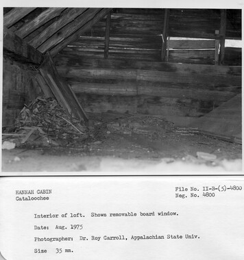
Cataloochee tract 251: James H. Hannah
-
Subscriptions received by the Appalachian National Park Association
-
Sugarland Valley with numbered peaks and valleys

-
Horace Kephart preferred life in a mountain camp to life in the city

-
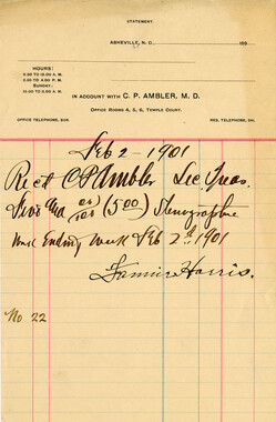
Financial receipts and expenditures, 1901
-
Guyot and the Great Smokies

-
Hikers at Indian Gap

-
Wilburn photograph album
-
Report of the Secretary of Agriculture in relation to the forests, rivers, and mountains of the southern Appalachian region

-
Cataloochee tract 214: Eldredge Caldwell – Levi

-
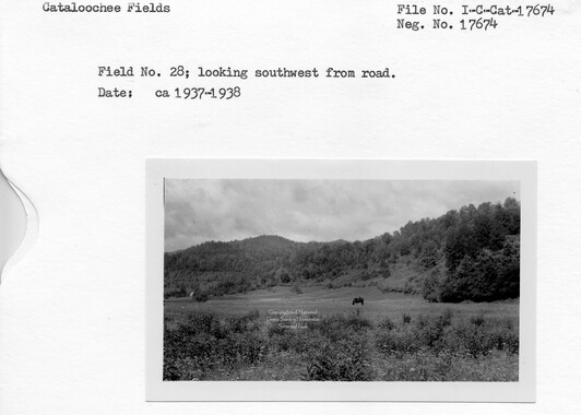
Cataloochee: fields