- Canton Champion Fibre Company (2308)
- Cherokee Traditions (291)
- Civil War in Southern Appalachia (165)
- Craft Revival (1942)
- George Masa Collection (135)
- Great Smoky Mountains - A Park for America (2901)
- Highlights from Western Carolina University (422)
- Horace Kephart (941)
- Journeys Through Jackson (159)
- LGBTQIA+ Archive of Jackson County (85)
- Oral Histories of Western North Carolina (314)
- Picturing Appalachia (6798)
- Stories of Mountain Folk (413)
- Travel Western North Carolina (153)
- Western Carolina University Fine Art Museum Vitreograph Collection (129)
- Western Carolina University Herbarium (92)
- Western Carolina University: Making Memories (738)
- Western Carolina University Publications (2491)
- Western Carolina University Restricted Electronic Theses and Dissertations (146)
- Western North Carolina Regional Maps (71)
- World War II in Southern Appalachia (131)
- Allanstand Cottage Industries (62)
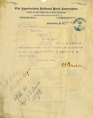
- Appalachian National Park Association (53)
- Bennett, Kelly, 1890-1974 (1463)
- Berry, Walter (76)
- Brasstown Carvers (40)
- Carver, George Washington, 1864?-1943 (26)
- Cathey, Joseph, 1803-1874 (1)
- Champion Fibre Company (233)
- Champion Paper and Fibre Company (297)
- Cherokee Indian Fair Association (16)
- Cherokee Language Program (22)
- Crowe, Amanda (40)
- Edmonston, Thomas Benton, 1842-1907 (7)
- Ensley, A. L. (Abraham Lincoln), 1865-1948 (275)
- Fromer, Irving Rhodes, 1913-1994 (70)
- George Butz (BFS 1907) (46)
- Goodrich, Frances Louisa (120)
- Grant, George Alexander, 1891-1964 (96)
- Heard, Marian Gladys (60)
- Kephart, Calvin, 1883-1969 (15)
- Kephart, Horace, 1862-1931 (313)
- Kephart, Laura, 1862-1954 (39)
- Laney, Gideon Thomas, 1889-1976 (439)
- Masa, George, 1881-1933 (61)
- McElhinney, William Julian, 1896-1953 (44)
- Niggli, Josephina, 1910-1983 (10)
- North Carolina Park Commission (105)
- Osborne, Kezia Stradley (9)
- Owens, Samuel Robert, 1918-1995 (11)
- Penland Weavers and Potters (36)
- Roberts, Vivienne (15)
- Roth, Albert, 1890-1974 (142)
- Schenck, Carl Alwin, 1868-1955 (1)
- Sherrill's Photography Studio (2565)
- Southern Highland Handicraft Guild (127)
- Southern Highlanders, Inc. (71)
- Stalcup, Jesse Bryson (46)
- Stearns, I. K. (213)
- Thompson, James Edward, 1880-1976 (226)
- United States. Indian Arts and Crafts Board (130)
- USFS (683)
- Vance, Zebulon Baird, 1830-1894 (1)
- Weaver, Zebulon, 1872-1948 (58)
- Western Carolina College (230)
- Western Carolina Teachers College (282)
- Western Carolina University (2008)
- Western Carolina University. Mountain Heritage Center (18)
- Whitman, Walt, 1819-1892 (10)
- Wilburn, Hiram Coleman, 1880-1967 (73)
- Williams, Isadora (3)
- Cain, Doreyl Ammons (0)
- Crittenden, Lorraine (0)
- Rhodes, Judy (0)
- Smith, Edward Clark (0)
- Appalachian Region, Southern (2924)
- Asheville (N.C.) (1941)
- Avery County (N.C.) (26)
- Blount County (Tenn.) (195)
- Buncombe County (N.C.) (1672)
- Cherokee County (N.C.) (283)
- Clay County (N.C.) (556)
- Graham County (N.C.) (236)
- Great Smoky Mountains National Park (N.C. and Tenn.) (525)
- Haywood County (N.C.) (3569)
- Henderson County (N.C.) (70)
- Jackson County (N.C.) (4913)
- Knox County (Tenn.) (35)
- Knoxville (Tenn.) (13)
- Lake Santeetlah (N.C.) (10)
- Macon County (N.C.) (420)
- Madison County (N.C.) (215)
- McDowell County (N.C.) (39)
- Mitchell County (N.C.) (135)
- Polk County (N.C.) (35)
- Qualla Boundary (982)
- Rutherford County (N.C.) (76)
- Swain County (N.C.) (2182)
- Transylvania County (N.C.) (270)
- Watauga County (N.C.) (12)
- Waynesville (N.C.) (86)
- Yancey County (N.C.) (72)
- Aerial Photographs (3)
- Aerial Views (60)
- Albums (books) (4)
- Articles (1)
- Artifacts (object Genre) (228)
- Bibliographies (1)
- Biography (general Genre) (2)
- Cards (information Artifacts) (38)
- Clippings (information Artifacts) (191)
- Copybooks (instructional Materials) (3)
- Crafts (art Genres) (622)
- Depictions (visual Works) (21)
- Design Drawings (1)
- Drawings (visual Works) (185)
- Envelopes (73)
- Exhibitions (events) (1)
- Facsimiles (reproductions) (1)
- Fiction (general Genre) (4)
- Financial Records (12)
- Fliers (printed Matter) (67)
- Glass Plate Negatives (381)
- Guidebooks (2)
- Internegatives (10)
- Interviews (815)
- Land Surveys (102)
- Letters (correspondence) (1013)
- Manuscripts (documents) (618)
- Maps (documents) (177)
- Memorandums (25)
- Minutes (administrative Records) (59)
- Negatives (photographs) (6090)
- Newsletters (1290)
- Newspapers (2)
- Notebooks (8)
- Occupation Currency (1)
- Paintings (visual Works) (1)
- Pen And Ink Drawings (1)
- Periodicals (193)
- Personal Narratives (10)
- Photographs (12976)
- Plans (maps) (1)
- Poetry (5)
- Portraits (4568)
- Postcards (329)
- Programs (documents) (181)
- Publications (documents) (2443)
- Questionnaires (65)
- Relief Prints (26)
- Sayings (literary Genre) (1)
- Scrapbooks (282)
- Sheet Music (2)
- Slides (photographs) (402)
- Songs (musical Compositions) (2)
- Sound Recordings (796)
- Specimens (92)
- Speeches (documents) (18)
- Tintypes (photographs) (8)
- Transcripts (322)
- Video Recordings (physical Artifacts) (23)
- Text Messages (0)
- A.L. Ensley Collection (275)
- Appalachian Industrial School Records (7)
- Appalachian National Park Association Records (336)
- Axley-Meroney Collection (2)
- Bayard Wootten Photograph Collection (20)
- Bethel Rural Community Organization Collection (7)
- Blumer Collection (5)
- C.W. Slagle Collection (20)
- Canton Area Historical Museum (2110)
- Carlos C. Campbell Collection (462)
- Cataloochee History Project (64)
- Cherokee Studies Collection (4)
- Daisy Dame Photograph Album (5)
- Daniel Boone VI Collection (1)
- Doris Ulmann Photograph Collection (112)
- Elizabeth H. Lasley Collection (1)
- Elizabeth Woolworth Szold Fleharty Collection (4)
- Frank Fry Collection (95)
- George Masa Collection (173)
- Gideon Laney Collection (452)
- Hazel Scarborough Collection (2)
- Hiram C. Wilburn Papers (28)
- Historic Photographs Collection (236)
- Horace Kephart Collection (861)
- Humbard Collection (33)
- Hunter and Weaver Families Collection (1)
- I. D. Blumenthal Collection (4)
- Isadora Williams Collection (4)
- Jesse Bryson Stalcup Collection (47)
- Jim Thompson Collection (224)
- John B. Battle Collection (7)
- John C. Campbell Folk School Records (80)
- John Parris Collection (6)
- Judaculla Rock project (2)
- Kelly Bennett Collection (1482)
- Love Family Papers (11)
- Major Wiley Parris Civil War Letters (3)
- Map Collection (12)
- McFee-Misemer Civil War Letters (34)
- Mountain Heritage Center Collection (4)
- Norburn - Robertson - Thomson Families Collection (44)
- Pauline Hood Collection (7)
- Pre-Guild Collection (2)
- Qualla Arts and Crafts Mutual Collection (12)
- R.A. Romanes Collection (681)
- Rosser H. Taylor Collection (1)
- Samuel Robert Owens Collection (94)
- Sara Madison Collection (144)
- Sherrill Studio Photo Collection (2558)
- Smoky Mountains Hiking Club Collection (616)
- Stories of Mountain Folk - Radio Programs (374)
- The Reporter, Western Carolina University (510)
- Venoy and Elizabeth Reed Collection (16)
- WCU Gender and Sexuality Oral History Project (32)
- WCU Mountain Heritage Center Oral Histories (25)
- WCU Oral History Collection - Mountain People, Mountain Lives (71)
- WCU Students Newspapers Collection (1923)
- Western North Carolina Tomorrow Black Oral History Project (69)
- William Williams Stringfield Collection (2)
- Zebulon Weaver Collection (109)
- African Americans (390)
- Appalachian Trail (35)
- Artisans (521)
- Cherokee art (84)
- Cherokee artists -- North Carolina (10)
- Cherokee language (21)
- Cherokee pottery (101)
- Cherokee women (208)
- Church buildings (190)
- Civilian Conservation Corps (U.S.) (111)
- College student newspapers and periodicals (2012)
- Dams (107)
- Dance (1023)
- Education (222)
- Floods (61)
- Folk music (1015)
- Forced removal, 1813-1903 (2)
- Forest conservation (220)
- Forests and forestry (1196)
- Gender nonconformity (4)
- Great Smoky Mountains National Park (N.C. and Tenn.) (181)
- Hunting (45)
- Landscape photography (25)
- Logging (119)
- Maps (83)
- Mines and mineral resources (8)
- North Carolina -- Maps (18)
- Paper industry (38)
- Postcards (255)
- Pottery (135)
- Railroad trains (72)
- Rural electrification -- North Carolina, Western (3)
- School integration -- Southern States (2)
- Segregation -- North Carolina, Western (5)
- Slavery (5)
- Sports (452)
- Storytelling (243)
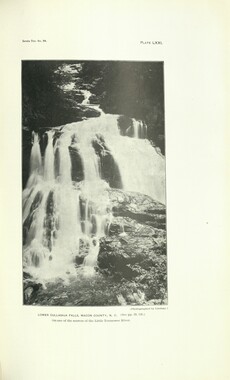
- Waterfalls -- Great Smoky Mountains (N.C. and Tenn.) (66)
- Weaving -- Appalachian Region, Southern (280)
- Wood-carving -- Appalachian Region, Southern (328)
- World War, 1939-1945 (173)
Report of the North Carolina Park Commission

Report of the North Carolina Park Commission
HL_F443_G7_N6_1939_01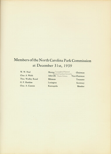
Report of the North Carolina Park Commission
HL_F443_G7_N6_1939_02
Report of the North Carolina Park Commission
HL_F443_G7_N6_1939_03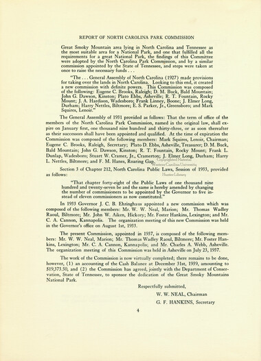
Report of the North Carolina Park Commission
HL_F443_G7_N6_1939_04
Report of the North Carolina Park Commission
HL_F443_G7_N6_1939_05
Report of the North Carolina Park Commission
HL_F443_G7_N6_1939_06
Report of the North Carolina Park Commission
HL_F443_G7_N6_1939_07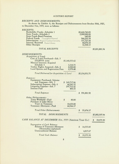
Report of the North Carolina Park Commission
HL_F443_G7_N6_1939_08
Report of the North Carolina Park Commission
HL_F443_G7_N6_1939_09
Report of the North Carolina Park Commission
HL_F443_G7_N6_1939_10
Report of the North Carolina Park Commission
HL_F443_G7_N6_1939_11
Report of the North Carolina Park Commission
HL_F443_G7_N6_1939_12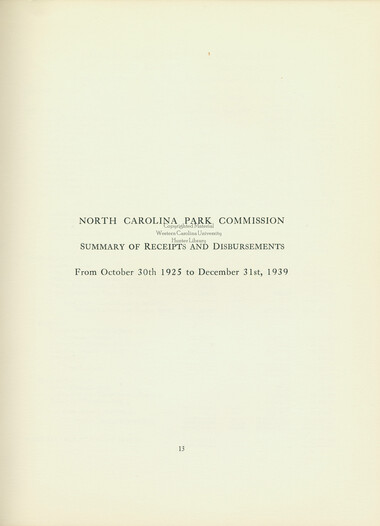
Report of the North Carolina Park Commission
HL_F443_G7_N6_1939_13
Report of the North Carolina Park Commission
HL_F443_G7_N6_1939_14
Report of the North Carolina Park Commission
HL_F443_G7_N6_1939_15
Report of the North Carolina Park Commission
HL_F443_G7_N6_1939_16
Report of the North Carolina Park Commission
HL_F443_G7_N6_1939_17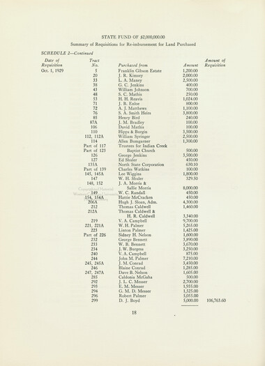
Report of the North Carolina Park Commission
HL_F443_G7_N6_1939_18
Report of the North Carolina Park Commission
HL_F443_G7_N6_1939_19
Report of the North Carolina Park Commission
HL_F443_G7_N6_1939_20
Report of the North Carolina Park Commission
HL_F443_G7_N6_1939_21
Report of the North Carolina Park Commission
HL_F443_G7_N6_1939_22
Report of the North Carolina Park Commission
HL_F443_G7_N6_1939_23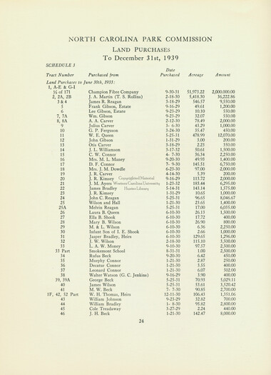
Report of the North Carolina Park Commission
HL_F443_G7_N6_1939_24
Report of the North Carolina Park Commission
HL_F443_G7_N6_1939_25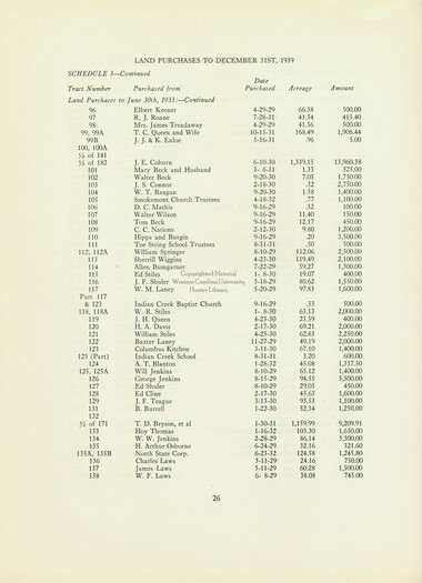
Report of the North Carolina Park Commission
HL_F443_G7_N6_1939_26
Report of the North Carolina Park Commission
HL_F443_G7_N6_1939_27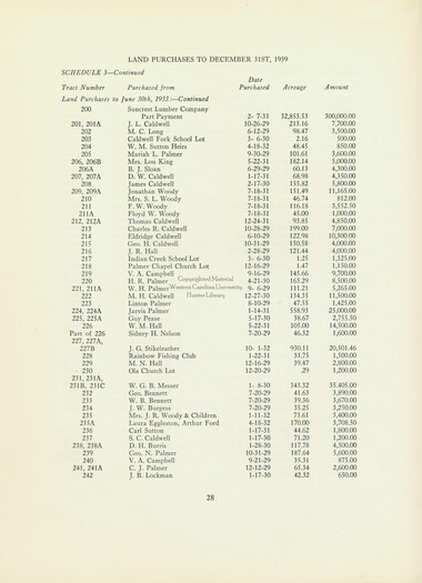
Report of the North Carolina Park Commission
HL_F443_G7_N6_1939_28
Report of the North Carolina Park Commission
HL_F443_G7_N6_1939_29
Report of the North Carolina Park Commission
HL_F443_G7_N6_1939_30
Report of the North Carolina Park Commission
HL_F443_G7_N6_1939_31
Report of the North Carolina Park Commission
HL_F443_G7_N6_1939_32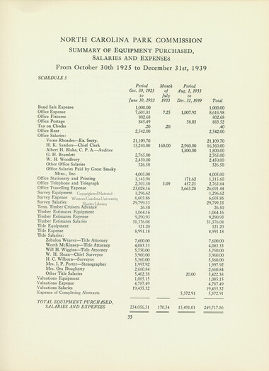
Report of the North Carolina Park Commission
HL_F443_G7_N6_1939_33
Report of the North Carolina Park Commission
HL_F443_G7_N6_1939_34
Report of the North Carolina Park Commission
HL_F443_G7_N6_1939_35
Report of the North Carolina Park Commission
HL_F443_G7_N6_1939_36
Report of the North Carolina Park Commission
HL_F443_G7_N6_1939_37
Report of the North Carolina Park Commission
HL_F443_G7_N6_1939_38
Report of the North Carolina Park Commission
HL_F443_G7_N6_1939_39
Report of the North Carolina Park Commission
HL_F443_G7_N6_1939_40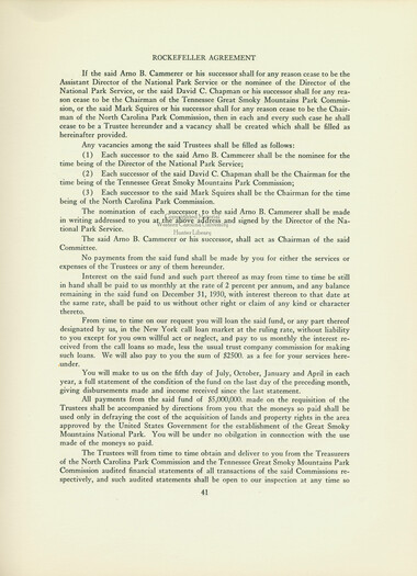
Report of the North Carolina Park Commission
HL_F443_G7_N6_1939_41
Report of the North Carolina Park Commission
HL_F443_G7_N6_1939_42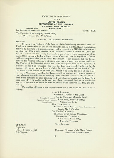
Report of the North Carolina Park Commission
HL_F443_G7_N6_1939_43
Report of the North Carolina Park Commission
HL_F443_G7_N6_1939_44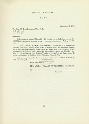
Report of the North Carolina Park Commission
HL_F443_G7_N6_1939_45
Report of the North Carolina Park Commission
HL_F443_G7_N6_1939_46
Report of the North Carolina Park Commission
HL_F443_G7_N6_1939_47
Report of the North Carolina Park Commission
HL_F443_G7_N6_1939_48
Report of the North Carolina Park Commission
HL_F443_G7_N6_1939_49
Report of the North Carolina Park Commission
HL_F443_G7_N6_1939_50
Report of the North Carolina Park Commission
HL_F443_G7_N6_1939_51
Report of the North Carolina Park Commission
HL_F443_G7_N6_1939_52
Report of the North Carolina Park Commission
HL_F443_G7_N6_1939_53
Report of the North Carolina Park Commission
HL_F443_G7_N6_1939_54
Report of the North Carolina Park Commission
HL_F443_G7_N6_1939_55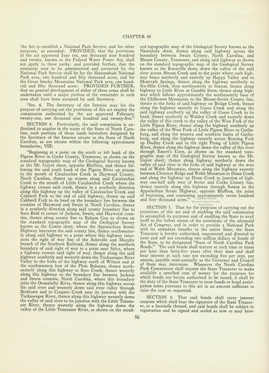
Report of the North Carolina Park Commission
HL_F443_G7_N6_1939_56
Report of the North Carolina Park Commission
HL_F443_G7_N6_1939_57
Report of the North Carolina Park Commission
HL_F443_G7_N6_1939_58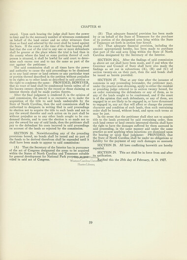
Report of the North Carolina Park Commission
HL_F443_G7_N6_1939_59
Report of the North Carolina Park Commission
HL_F443_G7_N6_1939_60
Report of the North Carolina Park Commission
HL_F443_G7_N6_1939_61
Report of the North Carolina Park Commission
HL_F443_G7_N6_1939_62Item’s are ‘child’ level descriptions to ‘parent’ objects, (e.g. one page of a whole book).
-
-
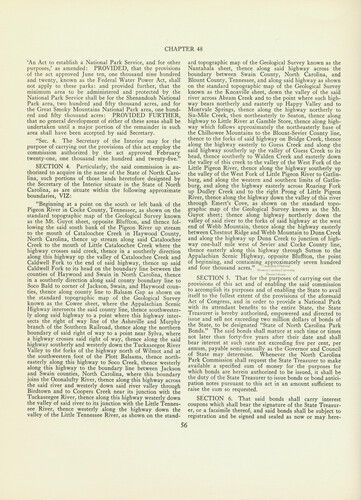
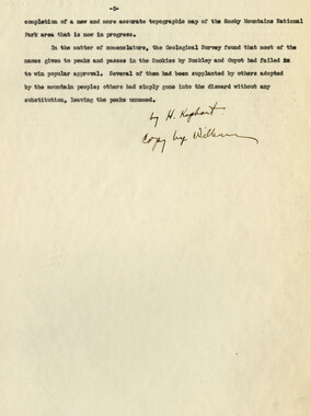
CHAPTER 48 'An Act to establish a National Park Service, and for other purposes,' as amended: PROVIDED, that the provisions of the act approved June ten, one thousand nine hundred and twenty, known as the Federal Water Power Act, shall not apply to these parks: and provided further, that the minimum area to be administered and protected by the National Park Service shall be for the Shenandoah National Park area, two hundred and fifty thousand acres, and for the Great Smoky Mountains National Park area, one hundred and fifty thousand acres: PROVIDED FURTHER, that no general development of either of these areas shall be undertaken until a major portion of the remainder in such area shall have been accepted by said Secretary. "Sec. 4. The Secretary of the Interior may for the purpose of carrying out the provisions of this act employ the commission authorized by the act approved February twenty-one, one thousand nine hundred and twenty-five." SECTION 4. Particularly, the said commission is authorized to acquire in the name of the State of North Carolina, such portions of those lands heretofore designted by the Secretary of the Interior situate in the State of North Carolina, as are situate within the following approximate boundaries, VIZ: "Beginning at a point on the south or left bank of the Pigeon River in Cocke County, Tennessee, as shown on the standard topographic map of the Geological Survey known as the Mt. Guyot sheet, opposite Bluffton, and thence following the said south bank of the Pigeon River up stream to the mouth of Cataloochee Creek in Haywood County, North Carolina, thence up stream along said Cataloochee Creek to the mouth of Little Cataloochee Creek where the highway crosses said creek, thence in a southerly direction along this highway up the valley of Cataloochee Creek and Caldwell Fork to the end of said highway, thence up said Caldwell Fork to its head on the boundary line between the counties of Haywood and Swain in North Carolina, thence in a southerly direction along said county boundary line to Soco Bald to corner of Jackson, Swain, and Haywood counties, thence along county line to Balsam Gap as shown on the standard topographic map of the Geological Survey known as the Cowee sheet, where the Appalachian Scenic Highway intersects the said county line, thence southwesterly along said highway to a point where this highway intersects the right of way line of the Asheville and Murphy branch of the Southern Railroad, thence along the northern boundary of said right of way to a point near Sylva, where a highway crosses said right of way, thence along the said highway southerly and westerly down the Tuckaseegee River Valley to the forks of the highway north of Wilmot and at the southwestern foot of the Plott Balsams, thence northeasterly along this highway to Soco Creek, thence westerly along this highway to the boundary line between Jackson and Swain counties, North Carolina, where this boundary joins the Oconalufty River, thence along this highway across the said river and westerly down said river valley through Birdtown and to Coopers Creek near its junction with the Tuckaseegee River, thence along this highway westerly down the valley of said river to its junction with the Little Tennessee River, thence westerly along the highway down the valley of the Little Tennessee River, as shown on the stand ard topographic map of the Geological Survey known as the Nantahala sheet, thence along said highway across the boundary between Swain County, North Carolina, and Blount County, Tennessee, and along said highway as shown on the standard topographic map of the Geological Survey known as the Knoxville sheet, down the valley of the said river across Abram Creek and to the point where such highway bears northerly and easterly up Happy Valley and to Montvale Springs, thence along the highway northerly to Six-Mile Creek, then northeasterly to Seaton, thence along highway to Little River at Gamble Store, thence along highway which follows approximately the northeasterly base of the Chilhowee Mountains to the Blount-Sevier County line, thence to the forks of said highway on Bridge Creek, thence along the highway easterly to Guess Creek and along the said highway southerly up the valley of Guess Creek to its head, thence southerly to Walden Creek and easterly down the valley of this creek to the valley of the West Fork of the Little Pigeon River, thence along the highway southerly up the valley of the West Fork of Little Pigeon River to Gatlin- burg, and along the western and southern limits of Gatlin- burg, and along the highway easterly across Roaring Fork up Dudley Creek and to the right Prong of Little Pigeon River, thence along the highway down the valley of this river through Emert's Cove, as shown on the standard topographic map of the Geological Survey known as the Mt. Guyot sheet; thence along highway northerly down the valley of said river to the forks of said highway at the west end of Webb Mountain, thence along the highway easterly between Chestnut Ridge and Webb Mountain to Dunn Creek and along the highway up Dunn Creek to junction of highway one-half mile west of Sevier and Cocke County line, thence easterly along this highway through Sutton to the Appalachian Scenic Highway, opposite Bluffton, the point of beginning, and containing approximately seven hundred and four thousand acres. ^^cLi^u,,™^ Hunter Library SECTION 5. That for the purposes of carrying out the provisions of this act and of enabling the said commission to accomplish its purposes and of enabling the State to avail itself to the fullest extent of the provisions of the aforesaid Act of Congress, and in order to provide a National Park with its attendant benefits to the entire State, the State Treasurer is hereby authorized, empowered and directed to issue and sell not exceeding two million dollars of bonds of the State, to be designated "State of North Carolina Park Bonds." The said bonds shall mature at such time or times not later than forty-five years after their date and shall bear interest at such rate not exceeding five per cent, per annum, payable semi-annually as the Governor and Council of State may determine. Whenever the North Carolina Park Commission shall request the State Treasurer to make available a specified sum of money for the purposes for which bonds are herein authorized to be issued, it shall be the duty of the State Treasurer to issue bonds or bond anticipation notes pursuant to this act in an amount sufficient to raise the sum so requested. SECTION 6. That said bonds shall carry interest coupons which shall bear the signature of the State Treasurer, or a facsimile thereof, and said bonds shall be subject to registration and be signed and sealed as now or may here- 56
Object’s are ‘parent’ level descriptions to ‘children’ items, (e.g. a book with pages).
-
This North Carolina Park Commission Report was completed at the close of 1939 and submitted to North Carolina Governor Clyde R. Hoey. The 62-page publication, compiled for the Commission by Albert H. Blake, begins with a letter to the governor reporting that all of the land on the North Carolina side of the park has been purchased and conveyed to the federal government. The report includes an auditor’s report, information about the Rockefeller fund, and a copy of the 1927 law that brought the commission into being. The report includes lists tracts of land, family names, and values paid for purchase. W.W. Neal was chairman of the commission at the time and G.F. Hankins was secretary.
-
Related items
-
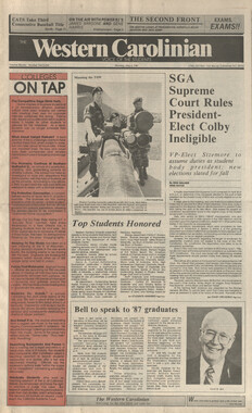
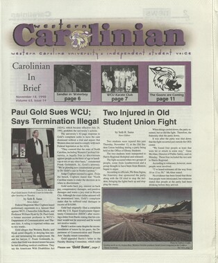
Western Carolinian Volume 59 Special Edition
-
Nature Magazine: Carolina number
-
Western Carolinian Volume 31 (39) Number 57
-
The Canton Enterprise Volume 22 Number 29

-
Western Carolinian Volume 52 Number 25
-
Western Carolinian Volume 41 Number 39
-
Western Carolinian Volume 52 Number 21
-
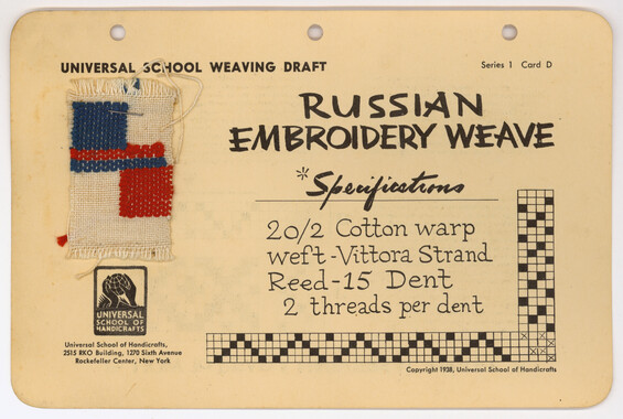
Universal School Weaving Draft: Russian Embroidery Weave
-
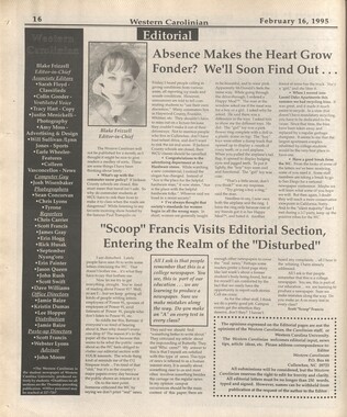
Western Carolinian Volume 63 (64) Number 14
-
Western Carolinian Volume 60 Number 20
-
Report of the Secretary of Agriculture in relation to the forests, rivers, and mountains of the southern Appalachian region
-
Western Carolinian Volume 57 Number 13

-
Western Carolinian Volume 26 Number 04
-
Western Carolinian Volume 60 Number 19

-
Cherokee Indian Fair 1934

-
Western Carolinian Volume 39 Number 58
-
Western Carolinian Volume 46 Number 16
-
Western Carolinian Volume 63 (64) Number 11

-
Champion Owns the Trees!
-
Western Carolinian Volume 61 Number 02 (03)
-
Western Carolinian Volume 61 Number 08 (09)

-
Western Carolinian Volume 64 (65) Number 19 (20)
-
Western Carolinian Volume 67 Number 06
-
Memories of District C: Civilian Conservation Corps
-
Western Carolinian Volume 70 Number 07
-
Cherokee Indian Fair 1948
-
Western Carolinian Volume 34 Number 08
-
Western Carolinian Volume 60 Number 18
-
Western Carolinian, August 25, 1994 (Volume 60 Number 03)
-
Great Smoky Mountains National Park / Land of the Everlasting Hills
-
Cullowhee Yodel Volume 02 Number 08
-
Western Carolinian Volume 62 Number 25
Part of Collection
Great Smoky Mountains - A Park for America
-
Appalachian National Park Association Newspaper Clippings, 1899-1902

-
Cataloochee tract 229: M. N. Hall

-
Nature Magazine: Carolina number

-
Unaka and the Pisgah

-
Trailwork on Brushy Trail

-
Senate Bill 5518
-
Program of hikes for 1930/ Smoky Mountains Hiking Club

-
Ann Morris and Ida Campbell on trail to Mount Sterling
-
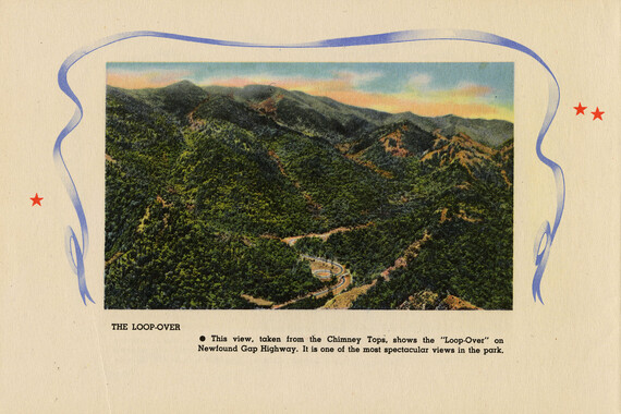
Between Newfound Gap and Indian Gap

-
Travel and banquet in Washington D.C.

-
Great Smoky Mountains National Park, North Carolina- Tennessee
-
Rifles: carving a rifle stock

-
Handbook/ 1933/ Smoky Mountains Hiking Club

-
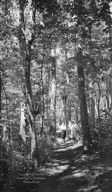
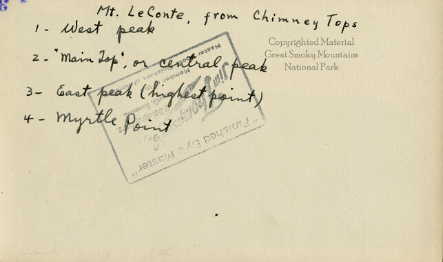
Mount LeConte from Chimney Tops
-
Handbook/ 1933/ Smoky Mountains Hiking Club
-
Origin of place names in the Great Smoky Mountains
-
Cataloochee tract 219: Milia Palmer

-
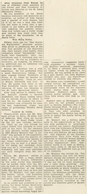
Kephart death is mourned by W.N.C.
-
Petitions supporting a National Park and Forest Reserve
-
Chimney Tops

-
Cataloochee tract 251: James H. Hannah

-
Report of the North Carolina Park Commission
-
Secretary of Agriculture visit

-
Cataloochee: pioneer artifacts

-
Hardwood Bark, 1924

-
Common forest trees of North Carolina

-
Appalachian National Park Association Newspaper Clippings, 1899-1902

-
Congressional speech for forest reserve
-
Memorandum to association president and members

-
Appalachian National Park Association Newspaper Clippings, 1899-1902

-
Cataloochee tract 226: W. M. Hall

-
Report of the Secretary of Agriculture in relation to the forests, rivers, and mountains of the southern Appalachian region
