- Canton Champion Fibre Company (2308)
- Cherokee Traditions (291)
- Civil War in Southern Appalachia (165)
- Craft Revival (1942)
- George Masa Collection (137)
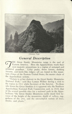
- Great Smoky Mountains - A Park for America (2900)
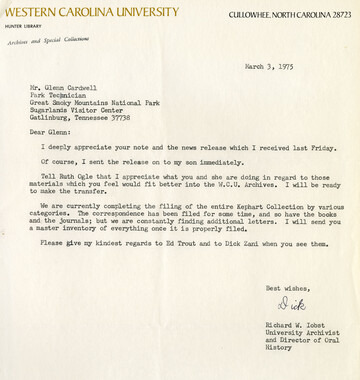
- Highlights from Western Carolina University (422)
- Horace Kephart (941)
- Journeys Through Jackson (159)
- LGBTQIA+ Archive of Jackson County (85)
- Oral Histories of Western North Carolina (314)
- Picturing Appalachia (6797)
- Stories of Mountain Folk (413)
- Travel Western North Carolina (153)
- Western Carolina University Fine Art Museum Vitreograph Collection (129)
- Western Carolina University Herbarium (92)
- Western Carolina University: Making Memories (738)
- Western Carolina University Publications (2491)
- Western Carolina University Restricted Electronic Theses and Dissertations (146)
- Western North Carolina Regional Maps (71)
- World War II in Southern Appalachia (131)
- Allanstand Cottage Industries (62)
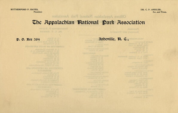
- Appalachian National Park Association (53)
- Bennett, Kelly, 1890-1974 (1463)
- Berry, Walter (76)
- Brasstown Carvers (40)
- Carver, George Washington, 1864?-1943 (26)
- Cathey, Joseph, 1803-1874 (1)
- Champion Fibre Company (233)
- Champion Paper and Fibre Company (297)
- Cherokee Indian Fair Association (16)
- Cherokee Language Program (22)
- Crowe, Amanda (40)
- Edmonston, Thomas Benton, 1842-1907 (7)
- Ensley, A. L. (Abraham Lincoln), 1865-1948 (275)
- Fromer, Irving Rhodes, 1913-1994 (70)
- George Butz (BFS 1907) (46)
- Goodrich, Frances Louisa (120)
- Grant, George Alexander, 1891-1964 (96)
- Heard, Marian Gladys (60)
- Kephart, Calvin, 1883-1969 (15)
- Kephart, Horace, 1862-1931 (313)
- Kephart, Laura, 1862-1954 (39)
- Laney, Gideon Thomas, 1889-1976 (439)
- Masa, George, 1881-1933 (61)
- McElhinney, William Julian, 1896-1953 (44)
- Niggli, Josephina, 1910-1983 (10)
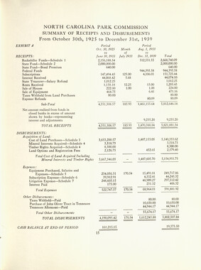
- North Carolina Park Commission (105)
- Osborne, Kezia Stradley (9)
- Owens, Samuel Robert, 1918-1995 (11)
- Penland Weavers and Potters (36)
- Roberts, Vivienne (15)
- Roth, Albert, 1890-1974 (142)
- Schenck, Carl Alwin, 1868-1955 (1)
- Sherrill's Photography Studio (2565)
- Southern Highland Handicraft Guild (127)
- Southern Highlanders, Inc. (71)
- Stalcup, Jesse Bryson (46)
- Stearns, I. K. (213)
- Thompson, James Edward, 1880-1976 (226)
- United States. Indian Arts and Crafts Board (130)
- USFS (683)
- Vance, Zebulon Baird, 1830-1894 (1)
- Weaver, Zebulon, 1872-1948 (58)
- Western Carolina College (230)
- Western Carolina Teachers College (282)
- Western Carolina University (2008)
- Western Carolina University. Mountain Heritage Center (18)
- Whitman, Walt, 1819-1892 (10)
- Wilburn, Hiram Coleman, 1880-1967 (73)
- Williams, Isadora (3)
- Cain, Doreyl Ammons (0)
- Crittenden, Lorraine (0)
- Rhodes, Judy (0)
- Smith, Edward Clark (0)
- Appalachian Region, Southern (2929)
- Asheville (N.C.) (1944)
- Avery County (N.C.) (26)
- Blount County (Tenn.) (195)
- Buncombe County (N.C.) (1680)
- Cherokee County (N.C.) (283)
- Clay County (N.C.) (556)
- Graham County (N.C.) (238)
- Great Smoky Mountains National Park (N.C. and Tenn.) (525)
- Haywood County (N.C.) (3571)
- Henderson County (N.C.) (70)
- Jackson County (N.C.) (4917)
- Knox County (Tenn.) (35)
- Knoxville (Tenn.) (13)
- Lake Santeetlah (N.C.) (10)
- Macon County (N.C.) (420)
- Madison County (N.C.) (216)
- McDowell County (N.C.) (39)
- Mitchell County (N.C.) (135)
- Polk County (N.C.) (35)
- Qualla Boundary (982)
- Rutherford County (N.C.) (78)
- Swain County (N.C.) (2185)
- Transylvania County (N.C.) (270)
- Watauga County (N.C.) (12)
- Waynesville (N.C.) (86)
- Yancey County (N.C.) (72)
- Aerial Photographs (3)
- Aerial Views (60)
- Albums (books) (4)
- Articles (1)
- Artifacts (object Genre) (228)
- Bibliographies (1)
- Biography (general Genre) (2)
- Cards (information Artifacts) (38)
- Clippings (information Artifacts) (191)
- Copybooks (instructional Materials) (3)
- Crafts (art Genres) (622)
- Depictions (visual Works) (21)
- Design Drawings (1)
- Drawings (visual Works) (185)
- Envelopes (73)
- Exhibitions (events) (1)
- Facsimiles (reproductions) (1)
- Fiction (general Genre) (4)
- Financial Records (12)
- Fliers (printed Matter) (67)
- Glass Plate Negatives (381)
- Guidebooks (2)
- Internegatives (10)
- Interviews (815)
- Land Surveys (102)
- Letters (correspondence) (1013)
- Manuscripts (documents) (618)
- Maps (documents) (177)
- Memorandums (25)
- Minutes (administrative Records) (59)
- Negatives (photographs) (6090)
- Newsletters (1290)
- Newspapers (2)
- Notebooks (8)
- Occupation Currency (1)
- Paintings (visual Works) (1)
- Pen And Ink Drawings (1)
- Periodicals (193)
- Personal Narratives (10)
- Photographs (12976)
- Plans (maps) (1)
- Poetry (5)
- Portraits (4568)
- Postcards (329)
- Programs (documents) (181)
- Publications (documents) (2443)
- Questionnaires (65)
- Relief Prints (26)
- Sayings (literary Genre) (1)
- Scrapbooks (282)
- Sheet Music (2)
- Slides (photographs) (402)
- Songs (musical Compositions) (2)
- Sound Recordings (796)
- Specimens (92)
- Speeches (documents) (18)
- Tintypes (photographs) (8)
- Transcripts (322)
- Video Recordings (physical Artifacts) (23)
- Text Messages (0)
- A.L. Ensley Collection (275)
- Appalachian Industrial School Records (7)
- Appalachian National Park Association Records (336)
- Axley-Meroney Collection (2)
- Bayard Wootten Photograph Collection (20)
- Bethel Rural Community Organization Collection (7)
- Blumer Collection (5)
- C.W. Slagle Collection (20)
- Canton Area Historical Museum (2110)
- Carlos C. Campbell Collection (462)
- Cataloochee History Project (64)
- Cherokee Studies Collection (4)
- Daisy Dame Photograph Album (5)
- Daniel Boone VI Collection (1)
- Doris Ulmann Photograph Collection (112)
- Elizabeth H. Lasley Collection (1)
- Elizabeth Woolworth Szold Fleharty Collection (4)
- Frank Fry Collection (95)
- George Masa Collection (173)
- Gideon Laney Collection (452)
- Hazel Scarborough Collection (2)
- Hiram C. Wilburn Papers (28)
- Historic Photographs Collection (236)
- Horace Kephart Collection (861)
- Humbard Collection (33)
- Hunter and Weaver Families Collection (1)
- I. D. Blumenthal Collection (4)
- Isadora Williams Collection (4)
- Jesse Bryson Stalcup Collection (47)
- Jim Thompson Collection (224)
- John B. Battle Collection (7)
- John C. Campbell Folk School Records (80)
- John Parris Collection (6)
- Judaculla Rock project (2)
- Kelly Bennett Collection (1482)
- Love Family Papers (11)
- Major Wiley Parris Civil War Letters (3)
- Map Collection (12)
- McFee-Misemer Civil War Letters (34)
- Mountain Heritage Center Collection (4)
- Norburn - Robertson - Thomson Families Collection (44)
- Pauline Hood Collection (7)
- Pre-Guild Collection (2)
- Qualla Arts and Crafts Mutual Collection (12)
- R.A. Romanes Collection (681)
- Rosser H. Taylor Collection (1)
- Samuel Robert Owens Collection (94)
- Sara Madison Collection (144)
- Sherrill Studio Photo Collection (2558)
- Smoky Mountains Hiking Club Collection (616)
- Stories of Mountain Folk - Radio Programs (374)
- The Reporter, Western Carolina University (510)
- Venoy and Elizabeth Reed Collection (16)
- WCU Gender and Sexuality Oral History Project (32)
- WCU Mountain Heritage Center Oral Histories (25)
- WCU Oral History Collection - Mountain People, Mountain Lives (71)
- WCU Students Newspapers Collection (1923)
- Western North Carolina Tomorrow Black Oral History Project (69)
- William Williams Stringfield Collection (2)
- Zebulon Weaver Collection (109)
- African Americans (390)
- Appalachian Trail (35)
- Artisans (521)
- Cherokee art (84)
- Cherokee artists -- North Carolina (10)
- Cherokee language (21)
- Cherokee pottery (101)
- Cherokee women (208)
- Church buildings (190)
- Civilian Conservation Corps (U.S.) (111)
- College student newspapers and periodicals (2012)
- Dams (108)
- Dance (1023)
- Education (222)
- Floods (61)
- Folk music (1015)
- Forced removal, 1813-1903 (2)
- Forest conservation (220)
- Forests and forestry (1196)
- Gender nonconformity (4)
- Great Smoky Mountains National Park (N.C. and Tenn.) (181)
- Hunting (46)
- Landscape photography (25)
- Logging (119)
- Maps (83)
- Mines and mineral resources (9)
- North Carolina -- Maps (18)
- Paper industry (38)
- Postcards (255)
- Pottery (135)
- Railroad trains (72)
- Rural electrification -- North Carolina, Western (3)
- School integration -- Southern States (2)
- Segregation -- North Carolina, Western (5)
- Slavery (5)
- Sports (452)
- Storytelling (243)
- Waterfalls -- Great Smoky Mountains (N.C. and Tenn.) (66)
- Weaving -- Appalachian Region, Southern (280)
- Wood-carving -- Appalachian Region, Southern (328)
- World War, 1939-1945 (173)
Handbook/ 1931/ Smoky Mountains Hiking Club
Handbook/ 1931/ Smoky Mountains Hiking Club
GSMNP_13150_53_02_1138_01
Handbook/ 1931/ Smoky Mountains Hiking Club
GSMNP_13150_53_02_1138_02
Handbook/ 1931/ Smoky Mountains Hiking Club
GSMNP_13150_53_02_1138_03
Handbook/ 1931/ Smoky Mountains Hiking Club
GSMNP_13150_53_02_1138_04
Handbook/ 1931/ Smoky Mountains Hiking Club
GSMNP_13150_53_02_1138_05
Handbook/ 1931/ Smoky Mountains Hiking Club
GSMNP_13150_53_02_1138_06
Handbook/ 1931/ Smoky Mountains Hiking Club
GSMNP_13150_53_02_1138_07
Handbook/ 1931/ Smoky Mountains Hiking Club
GSMNP_13150_53_02_1138_08
Handbook/ 1931/ Smoky Mountains Hiking Club
GSMNP_13150_53_02_1138_09
Handbook/ 1931/ Smoky Mountains Hiking Club
GSMNP_13150_53_02_1138_10
Handbook/ 1931/ Smoky Mountains Hiking Club
GSMNP_13150_53_02_1138_11
Handbook/ 1931/ Smoky Mountains Hiking Club
GSMNP_13150_53_02_1138_12
Handbook/ 1931/ Smoky Mountains Hiking Club
GSMNP_13150_53_02_1138_13
Handbook/ 1931/ Smoky Mountains Hiking Club
GSMNP_13150_53_02_1138_14
Handbook/ 1931/ Smoky Mountains Hiking Club
GSMNP_13150_53_02_1138_15
Handbook/ 1931/ Smoky Mountains Hiking Club
GSMNP_13150_53_02_1138_16
Handbook/ 1931/ Smoky Mountains Hiking Club
GSMNP_13150_53_02_1138_17
Handbook/ 1931/ Smoky Mountains Hiking Club
GSMNP_13150_53_02_1138_18
Handbook/ 1931/ Smoky Mountains Hiking Club
GSMNP_13150_53_02_1138_19
Handbook/ 1931/ Smoky Mountains Hiking Club
GSMNP_13150_53_02_1138_20
Handbook/ 1931/ Smoky Mountains Hiking Club
GSMNP_13150_53_02_1138_21
Handbook/ 1931/ Smoky Mountains Hiking Club
GSMNP_13150_53_02_1138_22
Handbook/ 1931/ Smoky Mountains Hiking Club
GSMNP_13150_53_02_1138_23
Handbook/ 1931/ Smoky Mountains Hiking Club
GSMNP_13150_53_02_1138_24
Handbook/ 1931/ Smoky Mountains Hiking Club
GSMNP_13150_53_02_1138_25
Handbook/ 1931/ Smoky Mountains Hiking Club
GSMNP_13150_53_02_1138_26
Handbook/ 1931/ Smoky Mountains Hiking Club
GSMNP_13150_53_02_1138_27
Handbook/ 1931/ Smoky Mountains Hiking Club
GSMNP_13150_53_02_1138_28
Handbook/ 1931/ Smoky Mountains Hiking Club
GSMNP_13150_53_02_1138_29
Handbook/ 1931/ Smoky Mountains Hiking Club
GSMNP_13150_53_02_1138_30
Handbook/ 1931/ Smoky Mountains Hiking Club
GSMNP_13150_53_02_1138_31
Handbook/ 1931/ Smoky Mountains Hiking Club
GSMNP_13150_53_02_1138_32
Handbook/ 1931/ Smoky Mountains Hiking Club
GSMNP_13150_53_02_1138_33
Handbook/ 1931/ Smoky Mountains Hiking Club
GSMNP_13150_53_02_1138_34
Handbook/ 1931/ Smoky Mountains Hiking Club
GSMNP_13150_53_02_1138_35
Handbook/ 1931/ Smoky Mountains Hiking Club
GSMNP_13150_53_02_1138_36
Handbook/ 1931/ Smoky Mountains Hiking Club
GSMNP_13150_53_02_1138_37
Handbook/ 1931/ Smoky Mountains Hiking Club
GSMNP_13150_53_02_1138_38
Handbook/ 1931/ Smoky Mountains Hiking Club
GSMNP_13150_53_02_1138_39
Handbook/ 1931/ Smoky Mountains Hiking Club
GSMNP_13150_53_02_1138_40
Handbook/ 1931/ Smoky Mountains Hiking Club
GSMNP_13150_53_02_1138_41
Handbook/ 1931/ Smoky Mountains Hiking Club
GSMNP_13150_53_02_1138_42
Handbook/ 1931/ Smoky Mountains Hiking Club
GSMNP_13150_53_02_1138_43
Handbook/ 1931/ Smoky Mountains Hiking Club
GSMNP_13150_53_02_1138_44
Handbook/ 1931/ Smoky Mountains Hiking Club
GSMNP_13150_53_02_1138_45
Handbook/ 1931/ Smoky Mountains Hiking Club
GSMNP_13150_53_02_1138_46
Handbook/ 1931/ Smoky Mountains Hiking Club
GSMNP_13150_53_02_1138_47
Handbook/ 1931/ Smoky Mountains Hiking Club
GSMNP_13150_53_02_1138_48
Handbook/ 1931/ Smoky Mountains Hiking Club
GSMNP_13150_53_02_1138_49
Handbook/ 1931/ Smoky Mountains Hiking Club
GSMNP_13150_53_02_1138_50
Handbook/ 1931/ Smoky Mountains Hiking Club
GSMNP_13150_53_02_1138_51
Handbook/ 1931/ Smoky Mountains Hiking Club
GSMNP_13150_53_02_1138_52
Handbook/ 1931/ Smoky Mountains Hiking Club
GSMNP_13150_53_02_1138_53
Handbook/ 1931/ Smoky Mountains Hiking Club
GSMNP_13150_53_02_1138_54
Handbook/ 1931/ Smoky Mountains Hiking Club
GSMNP_13150_53_02_1138_55
Handbook/ 1931/ Smoky Mountains Hiking Club
GSMNP_13150_53_02_1138_56
Handbook/ 1931/ Smoky Mountains Hiking Club
GSMNP_13150_53_02_1138_57
Handbook/ 1931/ Smoky Mountains Hiking Club
GSMNP_13150_53_02_1138_58
Handbook/ 1931/ Smoky Mountains Hiking Club
GSMNP_13150_53_02_1138_59
Handbook/ 1931/ Smoky Mountains Hiking Club
GSMNP_13150_53_02_1138_60
Handbook/ 1931/ Smoky Mountains Hiking Club
GSMNP_13150_53_02_1138_61
Handbook/ 1931/ Smoky Mountains Hiking Club
GSMNP_13150_53_02_1138_62
Handbook/ 1931/ Smoky Mountains Hiking Club
GSMNP_13150_53_02_1138_63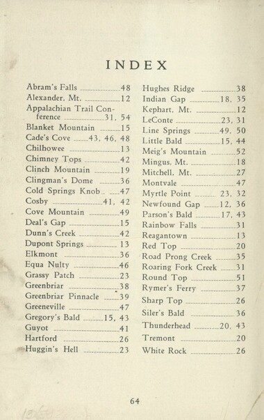
Handbook/ 1931/ Smoky Mountains Hiking Club
GSMNP_13150_53_02_1138_64
Handbook/ 1931/ Smoky Mountains Hiking Club
GSMNP_13150_53_02_1138_65_a
Handbook/ 1931/ Smoky Mountains Hiking Club
GSMNP_13150_53_02_1138_65_b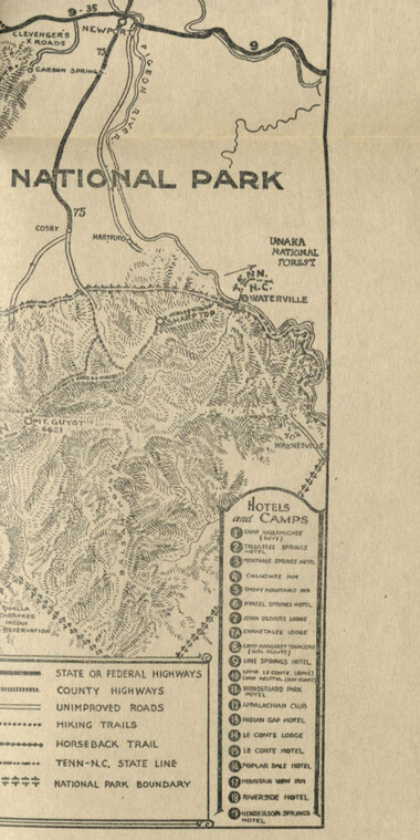
Handbook/ 1931/ Smoky Mountains Hiking Club
GSMNP_13150_53_02_1138_65_c
Handbook/ 1931/ Smoky Mountains Hiking Club
GSMNP_13150_53_02_1138_66Item’s are ‘child’ level descriptions to ‘parent’ objects, (e.g. one page of a whole book).
-
-
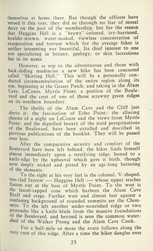
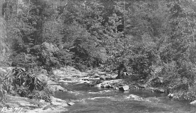
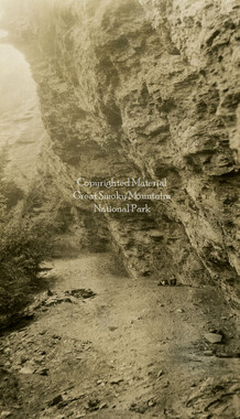
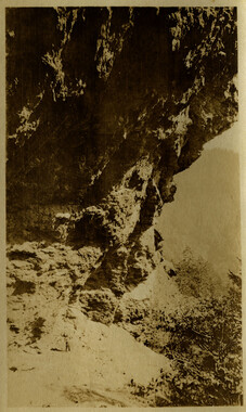
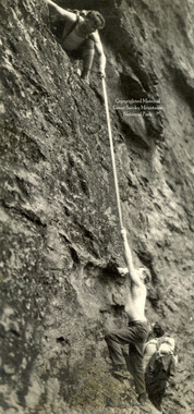
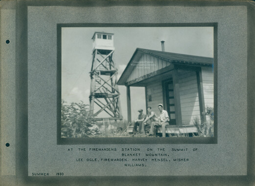
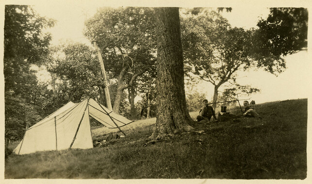
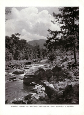
themselves at home there. But though the officers have vetoed it this year, they did so through no fear of moral decay on the part of the membership, but for the reason that Huggins Hell is a "brawr"-infested, ivy-barriered, boulder-strewn, water-soaked, viewless concentration of exasperation and torture which for the average hiker is neither interesting nor beautiful. Its chief interest to one not specializing in botany, geology, or skin lacerations lies in its name. However, as sop to the adventurous and those with back-sliding tendencies a new hike has been concocted called "Skirting Hell." This will be a personally conducted circumambulation of the entire region along its rim, beginning at the Grassy Patch, and taking in the Alum Cave, LeConte, Myrtle Point, a portion of the Boulevard and the crest of one of those scrawny green ridges on its southern boundary. The thrills of the Alum Cave and the Cliff just above it; the fascination of Echo Point; the alluring charms of a night on LeConte and the views from Myrtle Point; and the dignified beauty of the staid peregrinations of the Boulevard, have been extolled and described in previous publications of the booklet. They will be passed over here. After the comparative security and comfort of the Boulevard have been left behind, the hiker finds himself almost immediately upon a terrifying ridge, honed to a knife-edge by the upheaval which gave it birth, though now deeply nicked and pitted by an age-long battering of the elements. To the right at his very feet is the colossal. V-shaped, tree-clad furrow — Huggins Hell —■ whose upper reaches flatten out at the base of Myrtle Point. To the west is the laurel-capped cone which harbors the Alum Cave Bluff and crags. Farther west and almost lost against a confusing background of rounded summits are the Chimneys. To the left another under-nourished ridge or two protrudes like a knife-blade from the massive foundations of the Boulevard, and beyond is seen the common watershed of the Walker Prong and the Alum Cave Creek. For a half-mile or more the route follows along the very crest of this ridge. After a time the hiker dangles over 25
Object’s are ‘parent’ level descriptions to ‘children’ items, (e.g. a book with pages).
-
In 1926, the Smoky Mountains Hiking Club began to print an annual handbook that outlined scheduled hikes for each month of the year, including winter. This 1931 handbook was collected by George Masa (1881-1933), a photographer active in the Appalachian Trail Club and in the movement to establish the Great Smoky Mountains National Park. The Smoky Mountains Hiking Club was formed after a group of outdoor enthusiasts hiked up to Mount LeConte in October 1924. Enjoying the spectacular views, the group returned to establish a formal hiking club to sponsor regularly-scheduled hikes into the Great Smoky Mountains.
-
Related items
-
Great Smoky Mountains National Park / Land of the Everlasting Hills

-
Great Smoky Mountains National Park

-
Knoxville and the Great Smokies

-
Great Smoky Mountains National Park
-
Big Creek Trail

-
How to Reach our New National Park in the Great Smoky Mountains

-
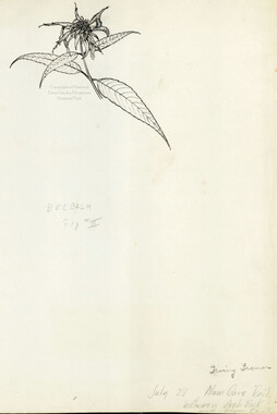
Bee balm
-
Deep Creek from Jenkins Place bridge
-
Hikers under Alum Cave Bluffs
-
Alum Cave
-
Best Loved Scenes in the Smokies
-
Smoky Mountains Hiking Club hikers
-
Best Loved Scenes in the Smokies

-
Guide to the Great Smoky Mountains National Park

-
Smokies Invite You

-
Dr. Chase P. Ambler

-
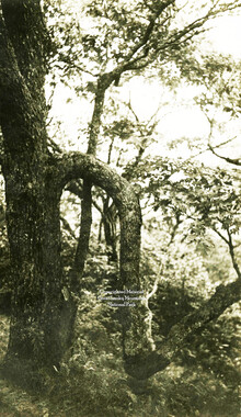
Oak tree
-
Great Smoky National Park:Travel Index

-
Handbook/ 1934/ Smoky Mountains Hiking Club

-
Great Smoky Mountains National Park Vicinity Map

-
Kelly Bennett and friends in Deep Creek

-
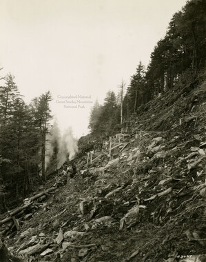
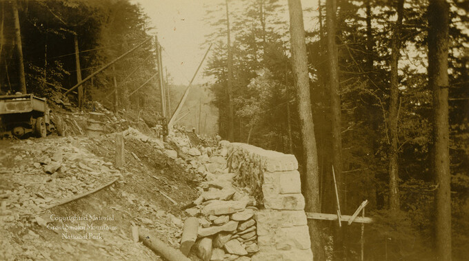
Skyway construction
-
Skyway construction with machinery
-
Hikers along trail near Alum Cave Bluff
-
Trip into the Smokies with Horace Kephart
-
Alum Cave Bluffs
-
Skyway construction: retaining wall
-
Andrews Bald

-
Walker Camp Prong

-
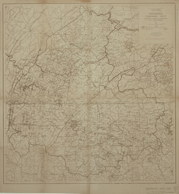
Cherokee Purchase Unit, Georgia, North Carolina and Tennessee
Part of Collection
Great Smoky Mountains - A Park for America
-
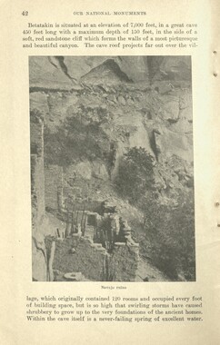
Glimpses of our National Monuments
-
Guide to the Great Smoky Mountains National Park
-
Study for the Preservation of Mountain Culture in Field Museum of History

-
Study for the Preservation of Mountain Culture in Field Museum of History

-
Report of the Secretary of Agriculture in relation to the forests, rivers, and mountains of the southern Appalachian region

-
Report of the Secretary of Agriculture in relation to the forests, rivers, and mountains of the southern Appalachian region

-
Mount Collins from Porter Gap
-
Great Smoky Mountains National Park

-
Photo Album of the Great Smokey Mountains
-
Appalachian National Park Association Newspaper Clippings, 1902-1907, 1925, 1928

-
Report of Investigations upon the Forests of the Southern Appalachian Mountain Region
-
Report of the Secretary of Agriculture in relation to the forests, rivers, and mountains of the southern Appalachian region

-
Cataloochee tract 226: W. M. Hall

-
Hikers on Mount LeConte
-
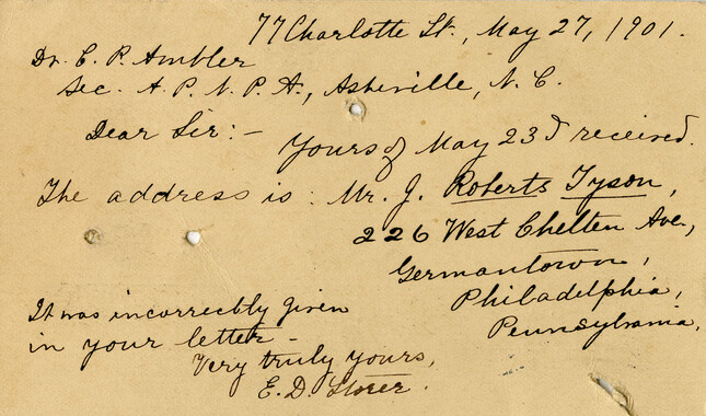
Correspondence: Chase Ambler to state geologist, December 1900

-
Cataloochee tract 206a: Lou Palmer King

-
Camp near Spence Cabin
-
Subscriptions received by the Appalachian National Park Association
-
Correspondence regarding Horace Kephart collection
-
Civilian Conservation Corps Annual: District "C"

-
Just the High Spots of Knoxville and East Tennessee

-
Great Smoky Mountains National Park / Land of the Everlasting Hills
-
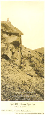
Rocky Spur on Mount LeConte
-
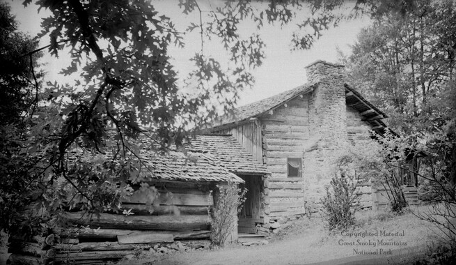
John Oliver's cabin
-
Complete Report Submitted to Governor Clyde R. Hoey
-
Letterhead, Appalachian National Park Association
-
Handbook/ 1933/ Smoky Mountains Hiking Club

-
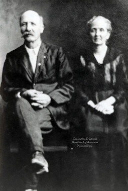
Henry Myers and Susan Clementine Gregory
-
Thornburgh Cottage
-
Handbook/ 1933/ Smoky Mountains Hiking Club

-
Cataloochee tract 225: Guy Pease

-
Appalachian National Park Association Newspaper Clippings, 1899-1902