Western Carolina University (20)
View all
- Canton Champion Fibre Company (2308)
- Cherokee Traditions (291)
- Civil War in Southern Appalachia (165)
- Craft Revival (1942)
- Great Smoky Mountains - A Park for America (2946)
- Highlights from Western Carolina University (430)
- Horace Kephart (941)
- Journeys Through Jackson (159)
- LGBTQIA+ Archive of Jackson County (85)
- Oral Histories of Western North Carolina (314)
- Picturing Appalachia (6873)
- Stories of Mountain Folk (413)
- Travel Western North Carolina (160)
- Western Carolina University Fine Art Museum Vitreograph Collection (129)
- Western Carolina University Herbarium (92)
- Western Carolina University: Making Memories (738)
- Western Carolina University Publications (2491)
- Western Carolina University Restricted Electronic Theses and Dissertations (146)
- Western North Carolina Regional Maps (71)
- World War II in Southern Appalachia (131)
University of North Carolina Asheville (6)
View all
- Allanstand Cottage Industries (62)
- Appalachian National Park Association (53)
- Bennett, Kelly, 1890-1974 (1463)
- Berry, Walter (76)
- Brasstown Carvers (40)
- Carver, George Washington, 1864?-1943 (26)
- Cathey, Joseph, 1803-1874 (1)
- Champion Fibre Company (233)
- Champion Paper and Fibre Company (297)
- Cherokee Indian Fair Association (16)
- Cherokee Language Program (22)
- Crowe, Amanda (40)
- Edmonston, Thomas Benton, 1842-1907 (7)
- Ensley, A. L. (Abraham Lincoln), 1865-1948 (275)
- Fromer, Irving Rhodes, 1913-1994 (70)
- George Butz (BFS 1907) (46)
- Goodrich, Frances Louisa (120)
- Grant, George Alexander, 1891-1964 (96)
- Heard, Marian Gladys (60)
- Kephart, Calvin, 1883-1969 (15)
- Kephart, Horace, 1862-1931 (313)
- Kephart, Laura, 1862-1954 (39)
- Laney, Gideon Thomas, 1889-1976 (439)
- Masa, George, 1881-1933 (61)
- McElhinney, William Julian, 1896-1953 (44)
- Niggli, Josephina, 1910-1983 (10)
- North Carolina Park Commission (105)
- Osborne, Kezia Stradley (9)
- Owens, Samuel Robert, 1918-1995 (11)
- Penland Weavers and Potters (36)
- Roberts, Vivienne (15)
- Roth, Albert, 1890-1974 (142)
- Schenck, Carl Alwin, 1868-1955 (1)
- Sherrill's Photography Studio (2565)
- Southern Highland Handicraft Guild (127)
- Southern Highlanders, Inc. (71)
- Stalcup, Jesse Bryson (46)
- Stearns, I. K. (213)
- Thompson, James Edward, 1880-1976 (226)
- United States. Indian Arts and Crafts Board (130)
- USFS (683)
- Vance, Zebulon Baird, 1830-1894 (1)
- Weaver, Zebulon, 1872-1948 (58)
- Western Carolina College (230)
- Western Carolina Teachers College (282)
- Western Carolina University (2008)
- Western Carolina University. Mountain Heritage Center (18)
- Whitman, Walt, 1819-1892 (10)
- Wilburn, Hiram Coleman, 1880-1967 (73)
- Williams, Isadora (3)
- Cain, Doreyl Ammons (0)
- Crittenden, Lorraine (0)
- Rhodes, Judy (0)
- Smith, Edward Clark (0)
- Appalachian Region, Southern (2693)
- Asheville (N.C.) (1936)
- Avery County (N.C.) (26)
- Blount County (Tenn.) (195)
- Buncombe County (N.C.) (1672)
- Cherokee County (N.C.) (283)
- Clay County (N.C.) (556)
- Graham County (N.C.) (236)
- Great Smoky Mountains National Park (N.C. and Tenn.) (519)
- Haywood County (N.C.) (3569)
- Henderson County (N.C.) (70)
- Jackson County (N.C.) (4913)
- Knox County (Tenn.) (35)
- Knoxville (Tenn.) (13)
- Lake Santeetlah (N.C.) (10)
- Macon County (N.C.) (420)
- Madison County (N.C.) (215)
- McDowell County (N.C.) (39)
- Mitchell County (N.C.) (132)
- Polk County (N.C.) (35)
- Qualla Boundary (982)
- Rutherford County (N.C.) (76)
- Swain County (N.C.) (2182)
- Transylvania County (N.C.) (270)
- Watauga County (N.C.) (12)
- Waynesville (N.C.) (86)
- Yancey County (N.C.) (72)
- Aerial Photographs (3)
- Aerial Views (60)
- Albums (books) (4)
- Articles (1)
- Artifacts (object Genre) (228)
- Bibliographies (1)
- Biography (general Genre) (2)
- Cards (information Artifacts) (38)
- Clippings (information Artifacts) (191)
- Copybooks (instructional Materials) (3)
- Crafts (art Genres) (622)
- Depictions (visual Works) (21)
- Design Drawings (1)
- Drawings (visual Works) (185)
- Envelopes (73)
- Exhibitions (events) (1)
- Facsimiles (reproductions) (1)
- Fiction (general Genre) (4)
- Financial Records (12)
- Fliers (printed Matter) (67)
- Glass Plate Negatives (381)
- Guidebooks (2)
- Internegatives (10)
- Interviews (815)
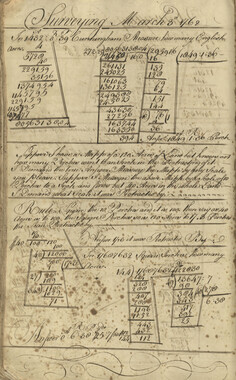
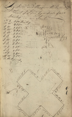
- Land Surveys (102)
- Letters (correspondence) (1013)
- Manuscripts (documents) (618)
- Maps (documents) (177)
- Memorandums (25)
- Minutes (administrative Records) (59)
- Negatives (photographs) (6090)
- Newsletters (1290)
- Newspapers (2)
- Notebooks (8)
- Occupation Currency (1)
- Paintings (visual Works) (1)
- Pen And Ink Drawings (1)
- Periodicals (193)
- Personal Narratives (10)
- Photographs (12976)
- Plans (maps) (1)
- Poetry (5)
- Portraits (4568)
- Postcards (329)
- Programs (documents) (181)
- Publications (documents) (2443)
- Questionnaires (65)
- Relief Prints (26)
- Sayings (literary Genre) (1)
- Scrapbooks (282)
- Sheet Music (2)
- Slides (photographs) (402)
- Songs (musical Compositions) (2)
- Sound Recordings (796)
- Specimens (92)
- Speeches (documents) (18)
- Tintypes (photographs) (8)
- Transcripts (322)
- Video Recordings (physical Artifacts) (23)
- Text Messages (0)
- A.L. Ensley Collection (275)
- Appalachian Industrial School Records (7)
- Appalachian National Park Association Records (336)
- Axley-Meroney Collection (2)
- Bayard Wootten Photograph Collection (20)
- Bethel Rural Community Organization Collection (7)
- Blumer Collection (5)
- C.W. Slagle Collection (20)
- Canton Area Historical Museum (2110)
- Carlos C. Campbell Collection (462)
- Cataloochee History Project (64)
- Cherokee Studies Collection (4)
- Daisy Dame Photograph Album (5)
- Daniel Boone VI Collection (1)
- Doris Ulmann Photograph Collection (112)
- Elizabeth H. Lasley Collection (1)
- Elizabeth Woolworth Szold Fleharty Collection (4)
- Frank Fry Collection (95)
- George Masa Collection (173)
- Gideon Laney Collection (452)
- Hazel Scarborough Collection (2)
- Hiram C. Wilburn Papers (28)
- Historic Photographs Collection (236)
- Horace Kephart Collection (861)
- Humbard Collection (33)
- Hunter and Weaver Families Collection (1)
- I. D. Blumenthal Collection (4)
- Isadora Williams Collection (4)
- Jesse Bryson Stalcup Collection (47)
- Jim Thompson Collection (224)
- John B. Battle Collection (7)
- John C. Campbell Folk School Records (80)
- John Parris Collection (6)
- Judaculla Rock project (2)
- Kelly Bennett Collection (1482)
- Love Family Papers (11)
- Major Wiley Parris Civil War Letters (3)
- Map Collection (12)
- McFee-Misemer Civil War Letters (34)
- Mountain Heritage Center Collection (4)
- Norburn - Robertson - Thomson Families Collection (44)
- Pauline Hood Collection (7)
- Pre-Guild Collection (2)
- Qualla Arts and Crafts Mutual Collection (12)
- R.A. Romanes Collection (681)
- Rosser H. Taylor Collection (1)
- Samuel Robert Owens Collection (94)
- Sara Madison Collection (144)
- Sherrill Studio Photo Collection (2558)
- Smoky Mountains Hiking Club Collection (616)
- Stories of Mountain Folk - Radio Programs (374)
- The Reporter, Western Carolina University (510)
- Venoy and Elizabeth Reed Collection (16)
- WCU Gender and Sexuality Oral History Project (32)
- WCU Mountain Heritage Center Oral Histories (25)
- WCU Oral History Collection - Mountain People, Mountain Lives (71)
- WCU Students Newspapers Collection (1923)
- Western North Carolina Tomorrow Black Oral History Project (69)
- William Williams Stringfield Collection (2)
- Zebulon Weaver Collection (109)
- African Americans (390)
- Appalachian Trail (35)
- Artisans (521)
- Cherokee art (84)
- Cherokee artists -- North Carolina (10)
- Cherokee language (21)
- Cherokee pottery (101)
- Cherokee women (208)
- Church buildings (190)
- Civilian Conservation Corps (U.S.) (111)
- College student newspapers and periodicals (2012)
- Dams (107)
- Dance (1023)
- Education (222)
- Floods (61)
- Folk music (1015)
- Forced removal, 1813-1903 (2)
- Forest conservation (220)
- Forests and forestry (1195)
- Gender nonconformity (4)
- Great Smoky Mountains National Park (N.C. and Tenn.) (181)
- Hunting (45)
- Landscape photography (25)
- Logging (119)
- Maps (83)
- Mines and mineral resources (8)
- North Carolina -- Maps (18)
- Paper industry (38)
- Postcards (255)
- Pottery (135)
- Railroad trains (72)
- Rural electrification -- North Carolina, Western (3)
- School integration -- Southern States (2)
- Segregation -- North Carolina, Western (5)
- Slavery (5)
- Sports (452)
- Storytelling (243)
- Waterfalls -- Great Smoky Mountains (N.C. and Tenn.) (66)
- Weaving -- Appalachian Region, Southern (280)
- Wood-carving -- Appalachian Region, Southern (328)
- World War, 1939-1945 (173)
Guyot and the Great Smokies


Guyot and the Great Smokies
GSMNP_13150_26_1066_15
Item
Item’s are ‘child’ level descriptions to ‘parent’ objects, (e.g. one page of a whole book).
-
-
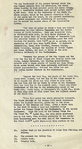
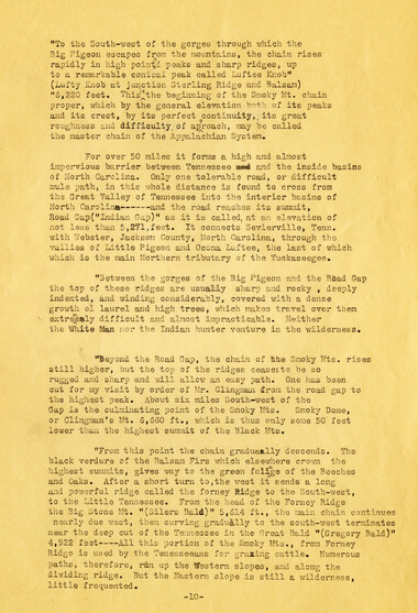
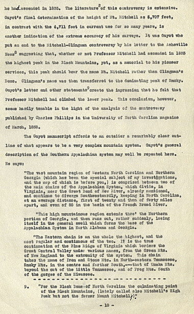
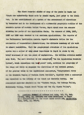
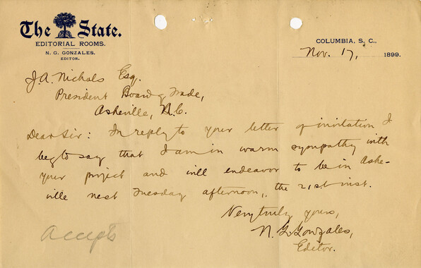
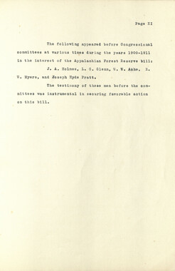
"To th* South-west of to© gorges through ehlch .the Big Bigeon escape* froa the aouatalns, the chain rises r©pidly in high pointed peaks and ©harp ridges, up to *■ remarkable conical peak called Loftee rnoblG 6,220 feet. Thi© i© to© beginning of the Smoky &t* ohs.ia proper, ©hi oh by toe general elevation bo to of Its peak* aad its crest, by its perfect ooatlsnity, its great roughs**© ©ad Glffloulty ef approach, may be called to© nsstffi chain of th© Appalachian System. "Per over 80 mil** it forms a high ©ad almost Impervious barrier between Teaasssae and toe la©id© basins of Horth Carolina. Only one tolerable read, or difficult ml© path, la this whole diateacs Is found to arena from to© Groat Valley of Tonnes©©© into too interior basins ©f Horth Carolina.• .and toe road reach©* its suawit. Load Gap-- a© it ie called, at an elevation of not less than 8,271 feet. It soaaect* Sevierville, Tens, with Webster, Jackson County. North Carolina, through toe vallies of Little rlgooa ©ad Ooeaa Lufteo, the last of which i© to© min lortoera tributary of toe Tuckass*g*s* "Between toe gorges of the Big Plgeoa ©ad the Load Gap the top of these ridgao are usually sharp and rocky, deeply iadeated, and winding considerably, covorad with a dens© growth ©f Laurel ©ad hl#i trees, toich mkss travel over them extremely difficult and elraact lepraetlcabla. neither toe sh.it© Ken nor the Indian hunter venture In the wlld©ra©»»* * + » » *Bay©»4 the Scud Cap,, the eh©ia of to© Smoky Its. rise* still higher, but toe top of toe ridge ceases to be so rugged ©ad sharp ©ad trial ftllo» an ©say path. one has bean out for my visit by order of Kr. GUngm&a from toe Head Gap to toe highest peek. About six rails* South-seat of the Gap ia the culminating point of toe Smoky Kts. Smoky Boss©, ©r Olingman** lit. 8,S60 ft., -which i© thus only aocse SO fast lower than the highest aasaait ef the Black fit*. "Trcm this point the chain gradually descend*. The black vsrdu** of the Belsam Firs which elaeehera crown the highest ensoiite, give© way to the groan foliage of toe Beeches and G«ks. After a short turn to the went it sends ft ion*'©ad powerful rldgs called the Peraey Bl&gft t© too touto-woet, to toe Little Tennessee. Prom toe haad of toe Porney **idge too Big stone Ut. lz 8,614 ft., the mla ehala ooatlaue* nearly due west, tosa curving gradually to to© uouth* *e*t tormiaat©* aear th© dee>» cut of the fenaSBsae in the Great Said-9 4,828 foot—-All this portion of toe 10. Luftes Knob at toe Junction of ridge from Sterling ©ad Balsam* 11. Th* present day Indian Gap, 18, Silera laid. 12. Gregory EaH. * 12 *
Object
Object’s are ‘parent’ level descriptions to ‘children’ items, (e.g. a book with pages).
-
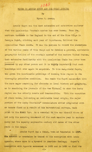
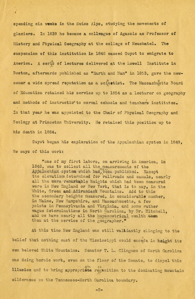
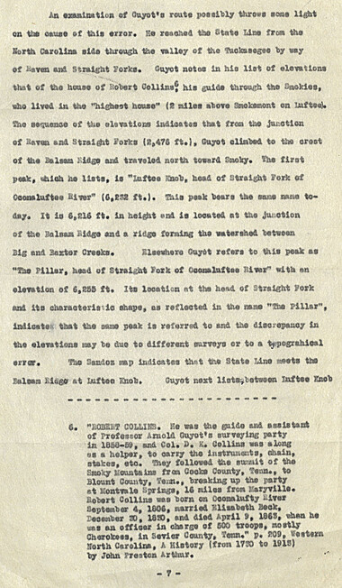
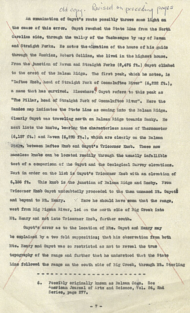
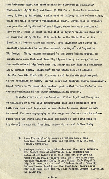
This 27-page manuscript recounts the involvement of Arnold Guyot in the Great Smoky Mountains. A geologist and geographer, Arnold Henry Guyot (1807-1884), began his exploration of the Appalachians in 1849. His purpose was to record the elevations of various peaks and develop a systematic geographic outline of the mountain systems of the eastern United States. The manuscript was collected by George Masa. Born Masahara Iizuka and raised in Japan, George Masa (1881-1933) emigrated to the U.S. when he was 20 years old and, in 1915, came to Asheville, where he lived the rest of his life. Masa was active in the Appalachian Trail Club and in the movement to establish the Great Smoky Mountains National Park. Myron Haliburton Avery (1899–1952), was president of the Potomac Appalachian Trail Club and chairman of the board of the Appalachian Trail Conference.
-
Related items
-
Activities of the Appalachian National Park Association and the Appalachian National Forest Reserve Association: 1899-1906
-
Activities of the Appalachian National Park Association and the Appalachian National Forest Reserve Association: 1899-1906
-
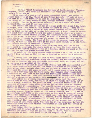
Blow-Guns
-
Nomenclature notebook: N.C. portion/ Great Smoky Mountains National Park

-
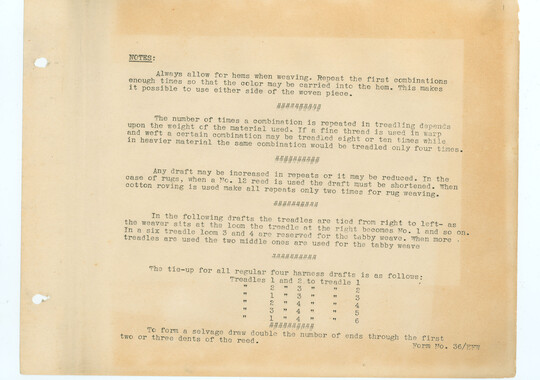
Isadora Williams Weaving Notebook I

-
Horace Kephart Journal 11

-
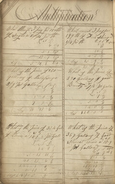
Anderson Copy Book
-
Weaving and dyeing in western North Carolina

-
William Twaddell copybook, 1761-1762
-
Activities of the Appalachian National Park Association and the Appalachian National Forest Reserve Association: 1899-1906
-
Unaka and the Pisgah
-
Anderson Copy Book

-
Anderson Copy Book
-
Beginning of history in the Great Smoky Mountains

-
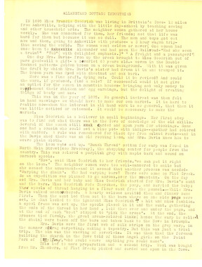
Allanstand Cottage Industries history, draft
-
Hospital Corps; 105's Battery B - 61st F. A. -- 1st Cal. Div.
-
William Twaddell copybook, 1761-1762
-
Anderson Copy Book

-
Account of the USS Canopus written by Capt. E. L. Sackett

-
William Twaddell copybook, 1761-1762

-
Anderson Copy Book
-
Guyot and the Great Smokies

-
Open-Air Camp. Naturalness, Simplicity

-
Nomenclature notebook: N.C. portion/ Great Smoky Mountains National Park
-
William Twaddell copybook, 1761-1762

-
Craft and membership standards, 1943
-
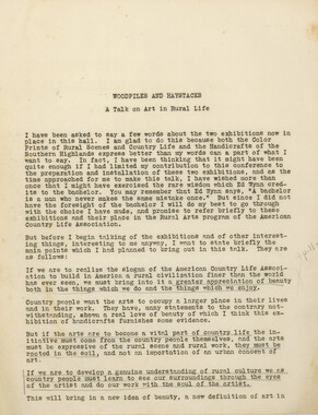
Woodpiles and Haystacks: a talk on art in rural life
-
Isadora Williams Weaving Notebook I
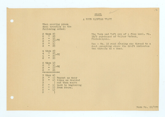
-
Isadora Williams Weaving Notebook II
-
Anderson Copy Book
-
Dialect of the Southern Mountaineers

-
Bark and Root Cordage

Part of Collection
Great Smoky Mountains - A Park for America
-
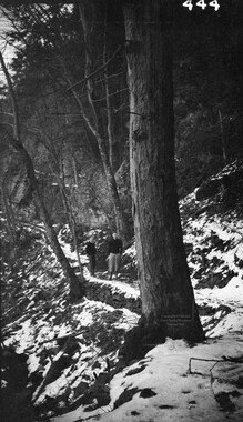
Bull Head trail from overhanging rock
-
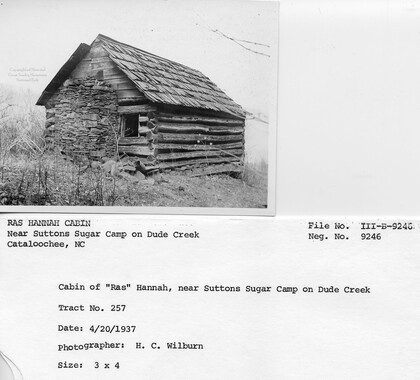
Cataloochee tract 257: W. R. Hannah
-
Nomenclature notes: place names in Smokies

-
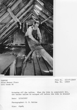
Cataloochee Cove Creek - Milas Messer
-
Western North Carolina R. R. Scenery: "Land of the Sky"

-
Appalachian National Park Association Newspaper Clippings, 1902-1907, 1925, 1928

-
Mount Mitchell (elevation 6711ft) from the Blackstock Trail

-
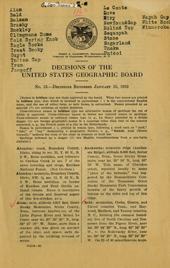
Nomenclature Decisions of the United States Geographic Board
-
Wonderland Park map

-
Climatic Treatment of Disease: Western North Carolina as a Health Resort

-
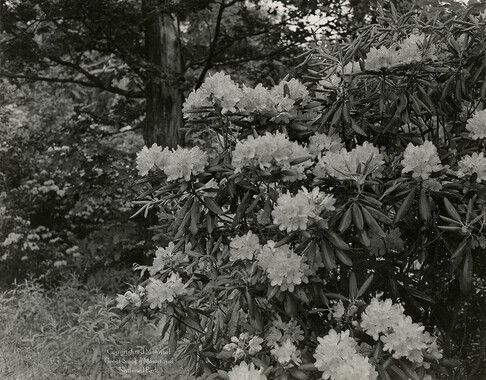
Rhododendron
-
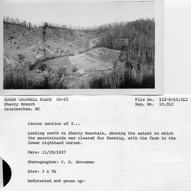
Cataloochee tract 215: George H. Caldwell
-
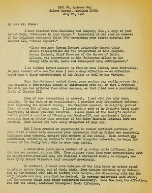
Correspondence: George Kephart to Michael Frome
-
Letters supporting Appalachian National Park movement
-
Park visitors at overlook

-
Correspondence between Zebulon Weaver and J. Ross Eakin, August, 1932

-
Correspondence regarding organizational meetings of the Appalachian National Park Association
-
Weeks Law Silver Jubilee
-
Why Should We Study Forestry?
-
Correspondence between John G. Dawson and Zebulon Weaver, 1934

-
Southern Pictures and Pencillings correspondence

-
Squirrels

-
Trees of the Great Smoky Mountains National Park

-
Activities of the Appalachian National Park Association and the Appalachian National Forest Reserve Association: 1899-1906
-
Nomenclature notes: suggested changes to place names

-
Activities of the Appalachian National Park Association and the Appalachian National Forest Reserve Association: 1899-1906
-
CCC enrollee at Camp NP-10, Company 1459

-
Guide to the Great Smoky Mountains National Park

-
Tramping in the Great Smokies

-
Congressional speech for forest reserve

-
Appalachian National Park Association Newspaper Clippings, 1899-1902

-
Civilian Conservation Corps Annual: District "C"