Western Carolina University (20)
View all
- Canton Champion Fibre Company (2308)
- Cherokee Traditions (291)
- Civil War in Southern Appalachia (165)
- Craft Revival (1942)
- Great Smoky Mountains - A Park for America (2946)
- Highlights from Western Carolina University (430)
- Horace Kephart (941)
- Journeys Through Jackson (159)
- LGBTQIA+ Archive of Jackson County (85)
- Oral Histories of Western North Carolina (314)
- Picturing Appalachia (6873)
- Stories of Mountain Folk (413)
- Travel Western North Carolina (160)
- Western Carolina University Fine Art Museum Vitreograph Collection (129)
- Western Carolina University Herbarium (92)
- Western Carolina University: Making Memories (738)
- Western Carolina University Publications (2491)
- Western Carolina University Restricted Electronic Theses and Dissertations (146)
- Western North Carolina Regional Maps (71)
- World War II in Southern Appalachia (131)
University of North Carolina Asheville (6)
View all
- Allanstand Cottage Industries (62)
- Appalachian National Park Association (53)
- Bennett, Kelly, 1890-1974 (1463)
- Berry, Walter (76)
- Brasstown Carvers (40)
- Carver, George Washington, 1864?-1943 (26)
- Cathey, Joseph, 1803-1874 (1)
- Champion Fibre Company (233)
- Champion Paper and Fibre Company (297)
- Cherokee Indian Fair Association (16)
- Cherokee Language Program (22)
- Crowe, Amanda (40)
- Edmonston, Thomas Benton, 1842-1907 (7)
- Ensley, A. L. (Abraham Lincoln), 1865-1948 (275)
- Fromer, Irving Rhodes, 1913-1994 (70)
- George Butz (BFS 1907) (46)
- Goodrich, Frances Louisa (120)
- Grant, George Alexander, 1891-1964 (96)
- Heard, Marian Gladys (60)
- Kephart, Calvin, 1883-1969 (15)
- Kephart, Horace, 1862-1931 (313)
- Kephart, Laura, 1862-1954 (39)
- Laney, Gideon Thomas, 1889-1976 (439)
- Masa, George, 1881-1933 (61)
- McElhinney, William Julian, 1896-1953 (44)
- Niggli, Josephina, 1910-1983 (10)
- North Carolina Park Commission (105)
- Osborne, Kezia Stradley (9)
- Owens, Samuel Robert, 1918-1995 (11)
- Penland Weavers and Potters (36)
- Roberts, Vivienne (15)
- Roth, Albert, 1890-1974 (142)
- Schenck, Carl Alwin, 1868-1955 (1)
- Sherrill's Photography Studio (2565)
- Southern Highland Handicraft Guild (127)
- Southern Highlanders, Inc. (71)
- Stalcup, Jesse Bryson (46)
- Stearns, I. K. (213)
- Thompson, James Edward, 1880-1976 (226)
- United States. Indian Arts and Crafts Board (130)
- USFS (683)
- Vance, Zebulon Baird, 1830-1894 (1)
- Weaver, Zebulon, 1872-1948 (58)
- Western Carolina College (230)
- Western Carolina Teachers College (282)
- Western Carolina University (2008)
- Western Carolina University. Mountain Heritage Center (18)
- Whitman, Walt, 1819-1892 (10)
- Wilburn, Hiram Coleman, 1880-1967 (73)
- Williams, Isadora (3)
- Cain, Doreyl Ammons (0)
- Crittenden, Lorraine (0)
- Rhodes, Judy (0)
- Smith, Edward Clark (0)
- Appalachian Region, Southern (2569)
- Asheville (N.C.) (1923)
- Avery County (N.C.) (26)
- Blount County (Tenn.) (195)
- Buncombe County (N.C.) (1672)
- Cherokee County (N.C.) (283)
- Clay County (N.C.) (555)
- Graham County (N.C.) (236)
- Great Smoky Mountains National Park (N.C. and Tenn.) (519)
- Haywood County (N.C.) (3569)
- Henderson County (N.C.) (70)
- Jackson County (N.C.) (4912)
- Knox County (Tenn.) (35)
- Knoxville (Tenn.) (13)
- Lake Santeetlah (N.C.) (10)
- Macon County (N.C.) (420)
- Madison County (N.C.) (215)
- McDowell County (N.C.) (39)
- Mitchell County (N.C.) (132)
- Polk County (N.C.) (35)
- Qualla Boundary (982)
- Rutherford County (N.C.) (76)
- Swain County (N.C.) (2182)
- Transylvania County (N.C.) (270)
- Watauga County (N.C.) (12)
- Waynesville (N.C.) (86)
- Yancey County (N.C.) (72)
- Aerial Photographs (3)
- Aerial Views (60)
- Albums (books) (4)
- Articles (1)
- Artifacts (object Genre) (228)
- Bibliographies (1)
- Biography (general Genre) (2)
- Cards (information Artifacts) (38)
- Clippings (information Artifacts) (191)
- Copybooks (instructional Materials) (3)
- Crafts (art Genres) (622)
- Depictions (visual Works) (21)
- Design Drawings (1)
- Drawings (visual Works) (185)
- Envelopes (73)
- Exhibitions (events) (1)
- Facsimiles (reproductions) (1)
- Fiction (general Genre) (4)
- Financial Records (12)
- Fliers (printed Matter) (67)
- Glass Plate Negatives (381)
- Guidebooks (2)
- Internegatives (10)
- Interviews (815)
- Land Surveys (102)
- Letters (correspondence) (1013)
- Manuscripts (documents) (618)
- Maps (documents) (177)
- Memorandums (25)
- Minutes (administrative Records) (59)
- Negatives (photographs) (6090)
- Newsletters (1290)
- Newspapers (2)
- Notebooks (8)
- Occupation Currency (1)
- Paintings (visual Works) (1)
- Pen And Ink Drawings (1)
- Periodicals (193)
- Personal Narratives (10)
- Photographs (12976)
- Plans (maps) (1)
- Poetry (5)
- Portraits (4568)
- Postcards (329)
- Programs (documents) (181)
- Publications (documents) (2443)
- Questionnaires (65)
- Relief Prints (26)
- Sayings (literary Genre) (1)
- Scrapbooks (282)
- Sheet Music (2)
- Slides (photographs) (402)
- Songs (musical Compositions) (2)
- Sound Recordings (796)
- Specimens (92)
- Speeches (documents) (18)
- Tintypes (photographs) (8)
- Transcripts (322)
- Video Recordings (physical Artifacts) (23)
- Text Messages (0)
- A.L. Ensley Collection (275)
- Appalachian Industrial School Records (7)
- Appalachian National Park Association Records (336)
- Axley-Meroney Collection (2)
- Bayard Wootten Photograph Collection (20)
- Bethel Rural Community Organization Collection (7)
- Blumer Collection (5)
- C.W. Slagle Collection (20)
- Canton Area Historical Museum (2110)
- Carlos C. Campbell Collection (462)
- Cataloochee History Project (64)
- Cherokee Studies Collection (4)
- Daisy Dame Photograph Album (5)
- Daniel Boone VI Collection (1)
- Doris Ulmann Photograph Collection (112)
- Elizabeth H. Lasley Collection (1)
- Elizabeth Woolworth Szold Fleharty Collection (4)
- Frank Fry Collection (95)
- George Masa Collection (173)
- Gideon Laney Collection (452)
- Hazel Scarborough Collection (2)
- Hiram C. Wilburn Papers (28)
- Historic Photographs Collection (236)
- Horace Kephart Collection (861)
- Humbard Collection (33)
- Hunter and Weaver Families Collection (1)
- I. D. Blumenthal Collection (4)
- Isadora Williams Collection (4)
- Jesse Bryson Stalcup Collection (47)
- Jim Thompson Collection (224)
- John B. Battle Collection (7)
- John C. Campbell Folk School Records (80)
- John Parris Collection (6)
- Judaculla Rock project (2)
- Kelly Bennett Collection (1482)
- Love Family Papers (11)
- Major Wiley Parris Civil War Letters (3)
- Map Collection (12)
- McFee-Misemer Civil War Letters (34)
- Mountain Heritage Center Collection (4)
- Norburn - Robertson - Thomson Families Collection (44)
- Pauline Hood Collection (7)
- Pre-Guild Collection (2)
- Qualla Arts and Crafts Mutual Collection (12)
- R.A. Romanes Collection (681)
- Rosser H. Taylor Collection (1)
- Samuel Robert Owens Collection (94)
- Sara Madison Collection (144)
- Sherrill Studio Photo Collection (2558)
- Smoky Mountains Hiking Club Collection (616)
- Stories of Mountain Folk - Radio Programs (374)
- The Reporter, Western Carolina University (510)
- Venoy and Elizabeth Reed Collection (16)
- WCU Gender and Sexuality Oral History Project (32)
- WCU Mountain Heritage Center Oral Histories (25)
- WCU Oral History Collection - Mountain People, Mountain Lives (71)
- WCU Students Newspapers Collection (1923)
- Western North Carolina Tomorrow Black Oral History Project (69)
- William Williams Stringfield Collection (2)
- Zebulon Weaver Collection (109)
- African Americans (390)
- Appalachian Trail (35)
- Artisans (521)
- Cherokee art (84)
- Cherokee artists -- North Carolina (10)
- Cherokee language (21)
- Cherokee pottery (101)
- Cherokee women (208)
- Church buildings (189)
- Civilian Conservation Corps (U.S.) (111)
- College student newspapers and periodicals (2012)
- Dams (107)
- Dance (1023)
- Education (222)
- Floods (61)
- Folk music (1015)
- Forced removal, 1813-1903 (2)
- Forest conservation (220)
- Forests and forestry (1184)
- Gender nonconformity (4)
- Great Smoky Mountains National Park (N.C. and Tenn.) (181)
- Hunting (45)
- Landscape photography (25)
- Logging (119)
- Maps (83)
- Mines and mineral resources (8)
- North Carolina -- Maps (18)
- Paper industry (38)
- Postcards (255)
- Pottery (135)
- Railroad trains (72)
- Rural electrification -- North Carolina, Western (3)
- School integration -- Southern States (2)
- Segregation -- North Carolina, Western (5)
- Slavery (5)
- Sports (452)
- Storytelling (243)
- Waterfalls -- Great Smoky Mountains (N.C. and Tenn.) (66)
- Weaving -- Appalachian Region, Southern (280)
- Wood-carving -- Appalachian Region, Southern (328)
- World War, 1939-1945 (173)
Guyot and the Great Smokies


Guyot and the Great Smokies
GSMNP_13150_21_1068_10


Item
Item’s are ‘child’ level descriptions to ‘parent’ objects, (e.g. one page of a whole book).
-
-
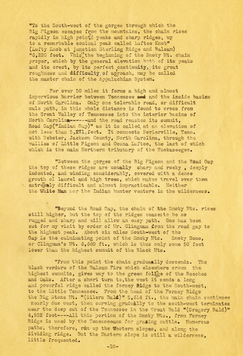
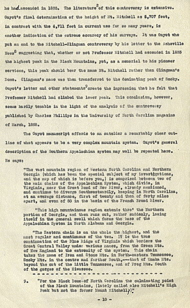
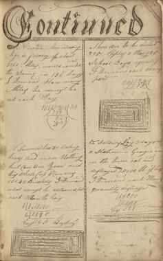
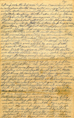
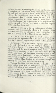
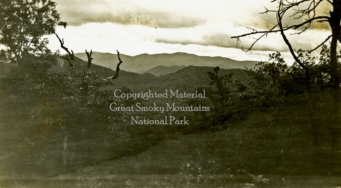
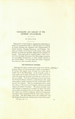
"To the South-west of the gorges through which the Big Pigeon escapes from the mountains, the chain rises rapidly in high points peaks and sharp ridges, up to a remarkable conical peak called Luftee Knob" (Lufty Knob at junction Sterling Ridge and Balsam) "6,220 feet. This^tbe beginning of the Smoky Mt. chain proper, which by the general elevation both of its peaks and its crest, by its perfect continuity,; its great roughness and difficulty,, of aproach, may be called the master chain of the Appalachian System. For over 50 miles it forms a high and almost impervious barrier between Tennessee $m& and the inside basins of North Carolina. Only one tolerable road, or difficult mule path, in this whole distance is found to cross from the Great Valley of Tennessee into the interior basins of North Carolina—-----and the road reaches its summit, Road Gap("Indian Cap)" as it is called, at an elevation of not less than 5,27i,feet. It connects Sevierville, Tenn. with Webster, Jackson County, North Carolina, through the vallles of Little Pigeon and Ocona Luftee, the last of which which is the main Northern tributary of the Tuckaseegee. "Between the gorges of the Big Pigeon and the Road Gap the top of these ridges are usually sharp and rocky , deeply indented, and winding considerably, covered with a dense growth ol laurel and high trees, which makes travel over them extreealv difficult and almost impracticable. Neither the White Man nor the Indian hunter venture in the wilderness. "Beyond the Road Gap, the chain of the Smoky Mts. rises still higher, but the top of the ridges ceasesto be so rugged and sharp and will allow an easy path. One has been cut for my visit by order of Mr. Clingman from the road gap to the highest peak. About six miles South-west of the Gap is the culminating point of the Smoky Mts. Smoky Dome, or Clingman's Mt. 6,660 ft., which is thus only some 50" feet lower than the highest summit of the Black Mts. "From this point the chain graduaally descends. The black verdure of the Balsam Firs which elsewhere crown the highest summits, gives way to the green folige of the Beeches and Oaks. After a short turn to,the west it sends a long and powerful ridge called the forney Ridge to the South-west, to the Little Tennessee. From the head of the Forney Ridge the Big ./tone Mt. "(Silers Bald)" 5,614 ft., the main chain continues nearly due wsci, then curving gradually to the south-west terminates near the deep cut of the Tennessee in the Great Bald "(Gregory Bald)" 4,922 feet——All this portion of the Smoky Mts., from Forney Ridge is used by the Tenesseeane for gr&sing cattle. Numerous paths, therefore, run up the Western slopes, and along the dividing ridge. But the Eastern slope is still a wilderness, little frequented. -10-
Object
Object’s are ‘parent’ level descriptions to ‘children’ items, (e.g. a book with pages).
-
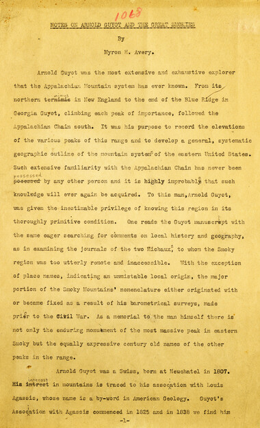
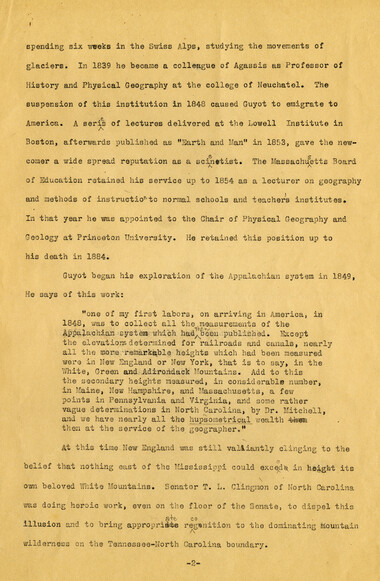
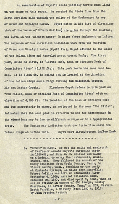
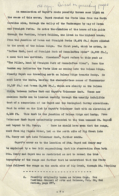
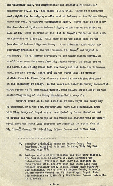
This 27-page manuscript recounts the involvement of Arnold Guyot in the Great Smoky Mountains. A geologist and geographer, Arnold Henry Guyot (1807-1884), began his exploration of the Appalachians in 1849. His purpose was to record the elevations of various peaks and develop a systematic geographic outline of the mountain systems of the eastern United States. The manuscript was collected by George Masa. Born Masahara Iizuka and raised in Japan, George Masa (1881-1933) emigrated to the U.S. when he was 20 years old and, in 1915, came to Asheville, where he lived the rest of his life. Masa was active in the Appalachian Trail Club and in the movement to establish the Great Smoky Mountains National Park. Myron Haliburton Avery (1899–1952), was president of the Potomac Appalachian Trail Club and chairman of the board of the Appalachian Trail Conference.
-
Related items
-
Anderson Copy Book
-
Anderson Copy Book
-
William Twaddell copybook, 1761-1762
-
William Twaddell copybook, 1761-1762

-
Nomenclature notebook: N.C. portion/ Great Smoky Mountains National Park

-
Isadora Williams Weaving Notebook II
-
William Twaddell copybook, 1761-1762

-
Nomenclature notes: Great Smoky Mountains: Origin of the name

-
Nomenclature notes: place names in N. C.
-
William Twaddell copybook, 1761-1762
-
Allanstand Cottage Industries Bylaws

-
Co-operative Plan for Handicrafts
-
Nomenclature notebook: N.C. portion/ Great Smoky Mountains National Park
-
Dialect of the Southern Mountaineers

-
Activities of the Appalachian National Park Association and the Appalachian National Forest Reserve Association: 1899-1906
-
Activities of the Appalachian National Park Association and the Appalachian National Forest Reserve Association: 1899-1906
-
Anderson Copy Book
-
Aboard ship on way to States by Carr Hooper
-
Woven cloth sample notebook

-
Anderson Copy Book

-
Our Southern Highlanders

-
Activities of the Appalachian National Park Association and the Appalachian National Forest Reserve Association: 1899-1906

-
Member file: Nancy Conseen, Cherokee basket maker
-
Stock Raising
-
Personal narrative of Robert Venoy Reed
-
Elisions
-
William Twaddell Copybook, 1758
-
Nomenclature notes: place names in N. C.
-
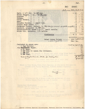
Heavy Ration List, Continuation
-
Cataloochee tract 255: Levi N. Hall

-
Horace Kephart and the Great Smoky Mountains National Park

Part of Collection
Great Smoky Mountains - A Park for America
-
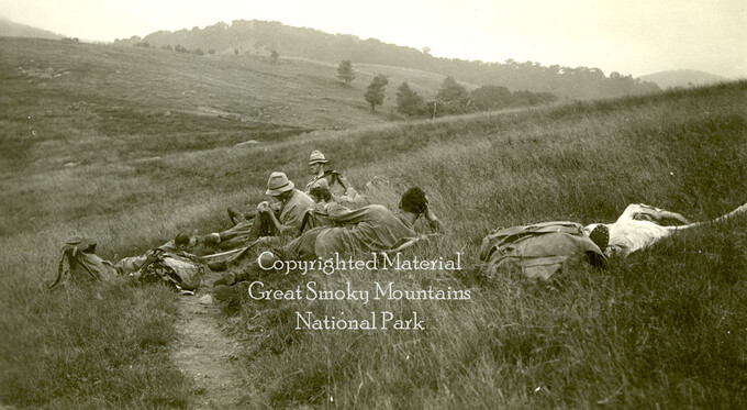
Hikers at Spence Field
-
Subscriptions received by the Appalachian National Park Association
-
Guide to the Great Smoky Mountains National Park

-
Brushy and Greenbrier Pinnacle

-
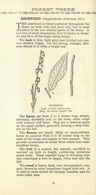
Common forest trees of North Carolina
-
Guide to the Great Smoky Mountains National Park
-
Memories of District C: Civilian Conservation Corps
-
Handbook/ 1931/ Smoky Mountains Hiking Club

-
Correspondence regarding organizational meetings of the Appalachian National Park Association

-
Family and cabin on Rich Mountain
-
Subscriptions received by the Appalachian National Park Association
-
Swim Bald and Cheoah Bald
-
Cataloochee tract 212a: Thomas Caldwell

-
Barn, Deep Creek, N.C.

-
Requests for information on Appalachian National Park

-
Civilian Conservation Corps Annual: District "C"

-
Bull Head trail from overhanging rock
-
Cataloochee tract 221: Will H. Palmer

-
Subscriptions solicited by the Appalachian National Park Association
-
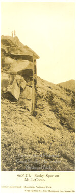
Rocky Spur on Mount LeConte
-
Trip into the Smokies with Horace Kephart
-
Nature Magazine: Carolina number
-
Photo Album of the Great Smokey Mountains

-
Study for the Preservation of Mountain Culture photographs and letter
-
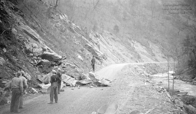
Rockslide on Scenic Loop Highway
-
Report of the Secretary of Agriculture in relation to the forests, rivers, and mountains of the southern Appalachian region
-
Cataloochee tract 224: Jarvis L. Palmer

-
Mount Mingus

-
Trips in the Smokies, 1930

-
Great Smokies

-
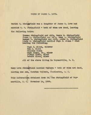
Love family heirs: James R. Love
-
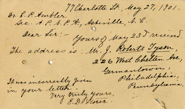
Correspondence regarding 1901 meeting