Western Carolina University (21)
View all
- Canton Champion Fibre Company (2308)
- Cherokee Traditions (291)
- Civil War in Southern Appalachia (165)
- Craft Revival (1942)
- George Masa Collection (137)
- Great Smoky Mountains - A Park for America (2900)
- Highlights from Western Carolina University (422)
- Horace Kephart (973)
- Journeys Through Jackson (159)
- LGBTQIA+ Archive of Jackson County (85)
- Oral Histories of Western North Carolina (316)
- Picturing Appalachia (6797)
- Stories of Mountain Folk (413)
- Travel Western North Carolina (153)
- Western Carolina University Fine Art Museum Vitreograph Collection (129)
- Western Carolina University Herbarium (92)
- Western Carolina University: Making Memories (738)
- Western Carolina University Publications (2491)
- Western Carolina University Restricted Electronic Theses and Dissertations (146)
- Western North Carolina Regional Maps (71)
- World War II in Southern Appalachia (131)
University of North Carolina Asheville (6)
View all
- Allanstand Cottage Industries (62)
- Appalachian National Park Association (53)
- Bennett, Kelly, 1890-1974 (1463)
- Berry, Walter (76)
- Brasstown Carvers (40)
- Carver, George Washington, 1864?-1943 (26)
- Cathey, Joseph, 1803-1874 (1)
- Champion Fibre Company (233)
- Champion Paper and Fibre Company (297)
- Cherokee Indian Fair Association (16)
- Cherokee Language Program (22)
- Crowe, Amanda (40)
- Edmonston, Thomas Benton, 1842-1907 (7)
- Ensley, A. L. (Abraham Lincoln), 1865-1948 (275)
- Fromer, Irving Rhodes, 1913-1994 (70)
- George Butz (BFS 1907) (46)
- Goodrich, Frances Louisa (120)
- Grant, George Alexander, 1891-1964 (96)
- Heard, Marian Gladys (60)
- Kephart, Calvin, 1883-1969 (15)
- Kephart, Horace, 1862-1931 (313)
- Kephart, Laura, 1862-1954 (67)
- Laney, Gideon Thomas, 1889-1976 (439)
- Masa, George, 1881-1933 (61)
- McElhinney, William Julian, 1896-1953 (44)
- Niggli, Josephina, 1910-1983 (10)
- North Carolina Park Commission (105)
- Osborne, Kezia Stradley (9)
- Owens, Samuel Robert, 1918-1995 (11)
- Penland Weavers and Potters (36)
- Roberts, Vivienne (15)
- Roth, Albert, 1890-1974 (142)
- Schenck, Carl Alwin, 1868-1955 (1)
- Sherrill's Photography Studio (2565)
- Southern Highland Handicraft Guild (127)
- Southern Highlanders, Inc. (71)
- Stalcup, Jesse Bryson (46)
- Stearns, I. K. (213)
- Thompson, James Edward, 1880-1976 (226)
- United States. Indian Arts and Crafts Board (130)
- USFS (683)
- Vance, Zebulon Baird, 1830-1894 (1)
- Weaver, Zebulon, 1872-1948 (58)
- Western Carolina College (230)
- Western Carolina Teachers College (282)
- Western Carolina University (2008)
- Western Carolina University. Mountain Heritage Center (18)
- Whitman, Walt, 1819-1892 (10)
- Wilburn, Hiram Coleman, 1880-1967 (73)
- Williams, Isadora (3)
- Cain, Doreyl Ammons (0)
- Crittenden, Lorraine (0)
- Rhodes, Judy (0)
- Smith, Edward Clark (0)
- Appalachian Region, Southern (2940)
- Asheville (N.C.) (1944)
- Avery County (N.C.) (26)
- Blount County (Tenn.) (195)
- Buncombe County (N.C.) (1680)
- Cherokee County (N.C.) (283)
- Clay County (N.C.) (556)
- Graham County (N.C.) (238)
- Great Smoky Mountains National Park (N.C. and Tenn.) (525)
- Haywood County (N.C.) (3573)
- Henderson County (N.C.) (70)
- Jackson County (N.C.) (4919)
- Knox County (Tenn.) (35)
- Knoxville (Tenn.) (13)
- Lake Santeetlah (N.C.) (10)
- Macon County (N.C.) (421)
- Madison County (N.C.) (216)
- McDowell County (N.C.) (39)
- Mitchell County (N.C.) (135)
- Polk County (N.C.) (35)
- Qualla Boundary (982)
- Rutherford County (N.C.) (78)
- Swain County (N.C.) (2185)
- Transylvania County (N.C.) (270)
- Watauga County (N.C.) (12)
- Waynesville (N.C.) (86)
- Yancey County (N.C.) (72)
- Aerial Photographs (3)
- Aerial Views (60)
- Albums (books) (4)
- Articles (1)
- Artifacts (object Genre) (228)
- Bibliographies (1)
- Biography (general Genre) (2)
- Cards (information Artifacts) (38)
- Clippings (information Artifacts) (192)
- Copybooks (instructional Materials) (3)
- Crafts (art Genres) (622)
- Depictions (visual Works) (21)
- Design Drawings (1)
- Digital Moving Image Formats (2)
- Drawings (visual Works) (185)
- Envelopes (101)
- Exhibitions (events) (1)
- Facsimiles (reproductions) (1)
- Fiction (general Genre) (4)
- Financial Records (12)
- Fliers (printed Matter) (67)
- Glass Plate Negatives (381)
- Guidebooks (2)
- Internegatives (10)
- Interviews (817)
- Land Surveys (102)
- Letters (correspondence) (1045)
- Manuscripts (documents) (618)
- Maps (documents) (177)
- Memorandums (25)
- Minutes (administrative Records) (59)
- Negatives (photographs) (6090)
- Newsletters (1290)
- Newspapers (2)
- Notebooks (8)
- Occupation Currency (1)
- Paintings (visual Works) (1)
- Pen And Ink Drawings (1)
- Periodicals (193)
- Personal Narratives (10)
- Photographs (12976)
- Plans (maps) (1)
- Poetry (6)
- Portraits (4568)
- Postcards (329)
- Programs (documents) (181)
- Publications (documents) (2444)
- Questionnaires (65)
- Relief Prints (26)
- Sayings (literary Genre) (1)
- Scrapbooks (282)
- Sheet Music (2)
- Slides (photographs) (402)
- Songs (musical Compositions) (2)
- Sound Recordings (796)
- Specimens (92)
- Speeches (documents) (18)
- Tintypes (photographs) (8)
- Transcripts (324)
- Text Messages (0)
- A.L. Ensley Collection (275)
- Appalachian Industrial School Records (7)
- Appalachian National Park Association Records (336)
- Axley-Meroney Collection (2)
- Bayard Wootten Photograph Collection (20)
- Bethel Rural Community Organization Collection (7)
- Blumer Collection (5)
- C.W. Slagle Collection (20)
- Canton Area Historical Museum (2110)
- Carlos C. Campbell Collection (462)
- Cataloochee History Project (64)
- Cherokee Studies Collection (4)
- Daisy Dame Photograph Album (5)
- Daniel Boone VI Collection (1)
- Doris Ulmann Photograph Collection (112)
- Elizabeth H. Lasley Collection (1)
- Elizabeth Woolworth Szold Fleharty Collection (4)
- Frank Fry Collection (95)
- George Masa Collection (173)
- Gideon Laney Collection (452)
- Hazel Scarborough Collection (2)
- Hiram C. Wilburn Papers (28)
- Historic Photographs Collection (236)
- Horace Kephart Collection (861)
- Humbard Collection (33)
- Hunter and Weaver Families Collection (1)
- I. D. Blumenthal Collection (4)
- Isadora Williams Collection (4)
- Jesse Bryson Stalcup Collection (47)
- Jim Thompson Collection (224)
- John B. Battle Collection (7)
- John C. Campbell Folk School Records (80)
- John Parris Collection (6)
- Judaculla Rock project (2)
- Kelly Bennett Collection (1482)
- Love Family Papers (11)
- Major Wiley Parris Civil War Letters (3)
- Map Collection (12)
- McFee-Misemer Civil War Letters (34)
- Mountain Heritage Center Collection (4)
- Norburn - Robertson - Thomson Families Collection (44)
- Pauline Hood Collection (7)
- Pre-Guild Collection (2)
- Qualla Arts and Crafts Mutual Collection (12)
- R.A. Romanes Collection (681)
- Rosser H. Taylor Collection (1)
- Samuel Robert Owens Collection (94)
- Sara Madison Collection (144)
- Sherrill Studio Photo Collection (2558)
- Smoky Mountains Hiking Club Collection (616)
- Stories of Mountain Folk - Radio Programs (374)
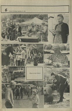
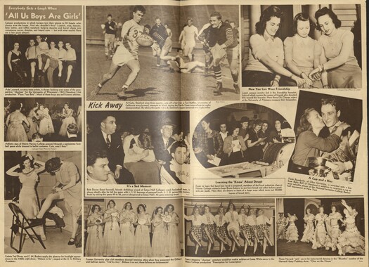
- The Reporter, Western Carolina University (510)
- Venoy and Elizabeth Reed Collection (16)
- WCU Gender and Sexuality Oral History Project (32)
- WCU Mountain Heritage Center Oral Histories (25)
- WCU Oral History Collection - Mountain People, Mountain Lives (71)
- WCU Students Newspapers Collection (1923)
- Western North Carolina Tomorrow Black Oral History Project (69)
- William Williams Stringfield Collection (2)
- Zebulon Weaver Collection (109)
- African Americans (390)
- Appalachian Trail (35)
- Artisans (521)
- Cherokee art (84)
- Cherokee artists -- North Carolina (10)
- Cherokee language (21)
- Cherokee pottery (101)
- Cherokee women (208)
- Church buildings (190)
- Civilian Conservation Corps (U.S.) (111)
- College student newspapers and periodicals (2012)
- Dams (108)
- Dance (1023)
- Education (222)
- Floods (63)
- Folk music (1015)
- Forced removal, 1813-1903 (2)
- Forest conservation (220)
- Forests and forestry (1197)
- Gender nonconformity (4)
- Great Smoky Mountains National Park (N.C. and Tenn.) (181)
- Hunting (46)
- Landscape photography (25)
- Logging (119)
- Maps (83)
- Mines and mineral resources (9)
- North Carolina -- Maps (18)
- Paper industry (38)
- Postcards (255)
- Pottery (135)
- Railroad trains (72)
- Rural electrification -- North Carolina, Western (3)
- School integration -- Southern States (2)
- Segregation -- North Carolina, Western (5)
- Slavery (5)
- Sports (452)
- Storytelling (243)
- Waterfalls -- Great Smoky Mountains (N.C. and Tenn.) (66)
- Weaving -- Appalachian Region, Southern (280)
- Wood-carving -- Appalachian Region, Southern (328)
- World War, 1939-1945 (173)
Cataloochee tract 207: D. W. Caldwell
Item 1 - Cataloochee tract 207: D. W. Caldwell

Cataloochee tract 207: D. W. Caldwell
GSMNP_Cata-207-207a
Cataloochee tract 207: D. W. Caldwell
GSMNP_80235
Item
Item’s are ‘child’ level descriptions to ‘parent’ objects, (e.g. one page of a whole book).
-
-
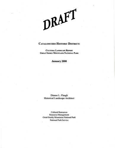
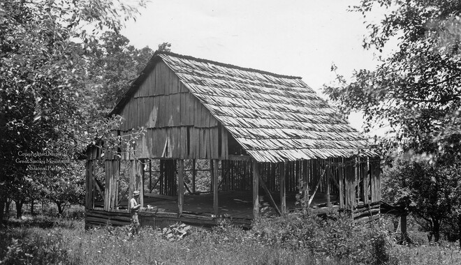
"CATALOOCHEE HISTORIC DISTRICT: CULTURAL LANDSCAPE REPORT GREAT SMOKY MOUNTAINS NATIONAL PARK January 2000 Dianne L. Flaugh Historical Landscape Architect Cultural Resources Resource Management Great Smoky Mountains National Park National Park Service CHAPTER 4: INDIVIDUAL TRACTS 105 D. W. Caldwell Tract (207a) Refer also to Palmer Methodist Church and Cemetery Tract (218) Location Tract 207a is an 18.6-acre parcel located north of Cataloochee Creek below the juncture ofPalmer Creek and Rough Fork. History This tract part of a larger parcel inherited by Elizabeth Palmer in 1896, from the estate of Jesse Palmer. After her death the property passed to her mother, Mary A. Palmer. Excluding a lot sold to Methodist Church trustees, this land passed to Thomas Palmer ( 1901 ); William and Milia Palmer (1922); J. R. Morgan, trustee ( 1925); and Dillard W. Caldwell in 1928. The NCPC purchased the property in 1931. Little is known of the early use of this parcel. It is likely that portions of this property, especially the level bottom land, were cleared and farmed. According to Gudger Palmer, the bam sat in the field behind the church, close to the CCC road. 1 Mark and Harold Hannah recair that the field was open-pasture and .livestock grazed right up to the church.2 Parts ofthis tract continued to be used for agriculture through 1941. Lush Caldwell leased and farmed eight acres ofbottomland on the tract from 1938, through 194l.ln 1942, designs were being completed for a campground that would have utilized portions ofthis tract. CCC crews began planting trees in the proposed campground area in 1942. Vegetation NCPC records indicate this tract consisted of twelve acres of bottomland and six acres of upland. Survey drawings (ca. 1935) made note only one apple tree. This tree could be found in the field behind the church. Circulation Cook's Lane ran through the Milia Palmer tract (219) along the east property line of the D. W. Caldwell tract 207a. Gudger Palmer recalls that Cook's Lane ran between two fence lines and along the branch east of the church to connect with the old settler road.3 The old settlers' road is found along the southern edge of this parcel near Cataloochee Creek. During the 1940s the CCC built a new road through the meadows of Cataloochee. It replaced the old settlers' road and cut through the fields of tract 207a at the rear of the church. A road on the west bank of Palmer Creek ran along the southwest boundary ofthis property. It provided access to farms along Palmer Creek and Davidson Branch. Structures, Furnishings, and Objects Records indicated that the property included a log house, frame chicken house, and log · bam with a galvanized iron roof A small sketch map shows that the house was located· ,I, I 106 CULTIJRAL LANDSCAPE REPORT: CATALOOCHEE HISTORIC DISTRICT west of the bam and closer to the old settler road. Gudger Palmer describes the location of the house as being up and across the current road from the bam. No specific dates of construction or photographs are available for the any of the structures. None of these buildings were noted on the survey drawings (ca. 1935). Survey drawings (ca. 1935) indicate that fencing divided the bottomland of this parcel into two fields. It also ran along the property lines and at the base of the slope. Except for the wood fence that separated the church lot from this parcel there is no indication of the types of fencing used on this parcel. Existing Conditions Visitors to the church use the open field behind Palmer Methodist Church for various recreational activities including picnics. During special events at the church parking is allowed on the field. A portion of the field behind the church has been maintained as neatly mown lawn. The western comer of this field and all land north of the CCC built road has reforested and is dominated by white pine, tulip poplar, red maple, and sycamore. Yucca plants found nearby the cemetery may mark the location of a structure or may have simply spread from the cemetery. Cook's Lane, in the immediate vicinity of Palmer Methodist Church Cemetery, is visible but beyond the cemetery entrance it becomes impossible to track. Cataloochee Creek Road (CCC built road) provides vehicular access to the church site. The road pavement ends here and the road surface becomes gravel. Visitors park along the edge of the road behind the church and near the bridge over Palmer Creek. The road that provided access to farms along Palmer Creek and Davidson Branch remains a narrow gravel lane approximately nine feet wide. It provides access to the horse camp. There are no obvious remnants of the structures that stood on this site. Nearly all signs of fencing have vanished except for a line of wood fence posts along the base ofthe slope. Analysis and Evaluation Other than the relationship of the open fieldwith Palmer Methodist Church little remains of the historic landscape. All of the other agricultural field areas have reforested. Some remnant fence posts and rock piles provided the only tie to agricultural use. There are no extant structures, and few clues about the organization of the historic structures. With the exception of the historic route along Palmer Creek there are no extensive traces of historic routes through the site. NOTES 1 Gudger Palmer, Interview by Jacqueline Lott and author, Written notes, Cataloochee, NC, 27 March 1998. 2 Mark Hannah and Harold Hannah, Jacqueline Lott, Written notes, Abingdon, VA, 28 October 1996. 3 Gudger Palmer, Interview by Jacqueline Lott and author.
Object
Object’s are ‘parent’ level descriptions to ‘children’ items, (e.g. a book with pages).
-
This 69-acres in Cataloochee tracts 207 and 207a were owned by D. W. Caldwell. While, in general, the Great Smoky Mountains region was sparsely populated, the Cataloochee Valley remained an exception. By 1900, the population of Cataloochee had grown to 1,000 residents living in hundreds of log and frame homes. A few historic buildings have been preserved on site, including two churches, a school, several homes, and outbuildings. The North Carolina Park Commission was tasked with purchasing land for the Great Smoky Mountains National Park and people living in Cataloochee were among those displaced. Cataloochee families continue to return for annual reunions. In 2001, the National Park Service re-introduced elk into the valley.
-
Related items
-
Western Carolinian Volume 40 Number 26
-
Western Carolinian Volume 48 Number 09
-
Western Carolinian March 26, 1941
-
Constitution and Laws of the Cherokee Nation
-
Western Carolinian Volume 37 Number 05
-
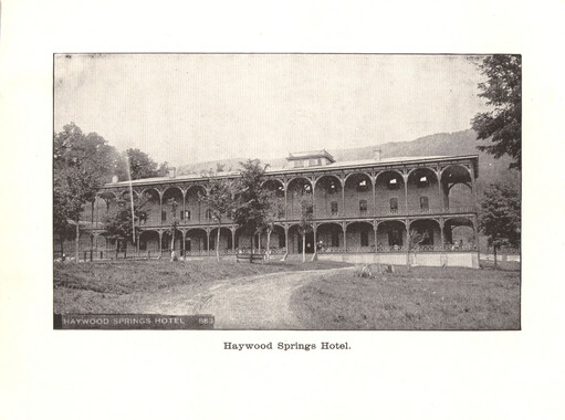
Haywood Springs Hotel
-
Western Carolinian Volume 77 Number 13
-
Western Carolinian Volume 68 Number 04
-
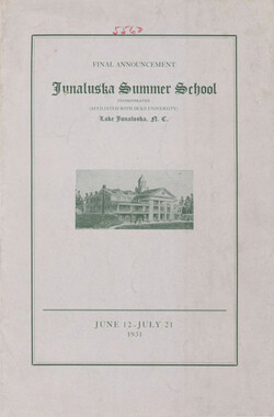
Final Announcement, Junaluska Summer School
-
Western Carolinian Volume 39 Number 43
-
Western Carolinian Volume 76 Number 02
-
Western Carolinian Volume 45 Number 16
-
Western Carolinian Volume 64 (65) Number 24
-
Western Carolinian Volume 50 Number 13
-
Civilian Conservation Corps Annual: District "C"
-
Western Carolinian Volume 39 Number 05
-
Western Carolinian Volume 48 Number 16
-
Sixteenth Annual Session of the Penland School of Handicrafts 1945, catalog, p. 3
-
Western Carolinian Volume 32 Number 12
-
Western Carolinian Volume 38 Number 12
-
Western Carolinian Volume 45 Number 25
-
Western Carolinian Volume 65 (66) Number 09
-
Western Carolinian Volume 48 Number 04
-
Cherokee Indian Fair 1947
-
Report of the Secretary of Agriculture in relation to the forests, rivers, and mountains of the southern Appalachian region
-
Western Carolinian Volume 34 Number 50
-
Western Carolinian Volume 72 Number 10
-
Western Carolinia Volume 47 Number 12
-
Western Carolinian Volume 50 Number 02
-
Story of the Penland Weavers page 3

-
Western Carolinian Volume 40 Number 57
-
Western Carolinian Volume 72 Number 07

Part of Collection
Great Smoky Mountains - A Park for America
-
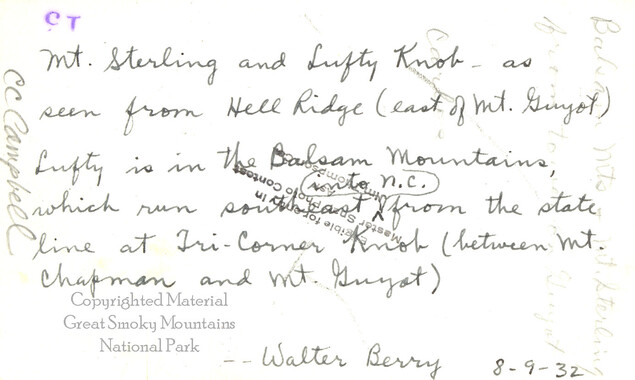
Mount Sterling and Luftee Knob
-
Cataloochee tract 245: J. M. Conrad

-
Minutes of Meetings of the Appalachian National Park Association

-
Hardwood Bark, 1924

-
Cataloochee tract 219: Milia Palmer

-
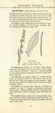
Common forest trees of North Carolina
-
Smoky Mountains Hiking Club

-
Activities of the Appalachian National Park Association and the Appalachian National Forest Reserve Association: 1899-1906
-
Early Explorers in the Great Smokies

-
Logging on Qualla Boundary
-
Hercules Club or Devil’s Walking Stick

-
Handbook/ 1933/ Smoky Mountains Hiking Club

-
Cataloochee tract 201: J. L. Caldwell

-
Round Top hikers

-
Great Smoky Mountains National Park / Land of the Everlasting Hills

-
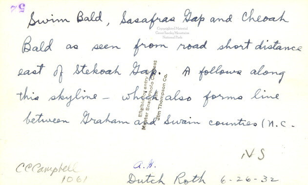
Swim Bald, Sassafras Gap, and Cheoah Bald
-
Mountain landscape

-
Dead chestnut tree

-
Appalachian National Park: Synopsis of work accomplished

-
History of the Appalachian National Park Association
-
Guyot and the Great Smokies
-
Report of the North Carolina Park Commission
-
Photo Album of the Great Smokey Mountains

-
Correspondence between O. E. Starnes and Zebulon Weaver, April, 1933
-
Cataloochee tract 245: J. M. Conrad
-
Correspondence: James E. Walker to Zebulon Weaver, January 17, 1925

-
Letters supporting Appalachian National Park movement
-
Handbook/ 1931/ Smoky Mountains Hiking Club
-
Correspondence regarding 1901 meeting

-
Financial receipts and expenditures, 1900

-
Financial receipts and expenditures, 1900

-
Correspondence regarding organizational meetings of the Appalachian National Park Association