- Canton Champion Fibre Company (6)
- Craft Revival (3)
- Great Smoky Mountains - A Park for America (520)
- Highlights from Western Carolina University (6)
- Horace Kephart (88)
- Oral Histories of Western North Carolina (30)
- Picturing Appalachia (1330)
- Stories of Mountain Folk (92)
- Travel Western North Carolina (27)
- Western Carolina University Herbarium (3)
- Western North Carolina Regional Maps (9)
- Cherokee Traditions (0)
- Civil War in Southern Appalachia (0)
- Journeys Through Jackson (0)
- LGBTQIA+ Archive of Jackson County (0)
- Western Carolina University Fine Art Museum Vitreograph Collection (0)
- Western Carolina University: Making Memories (0)
- Western Carolina University Publications (0)
- Western Carolina University Restricted Electronic Theses and Dissertations (0)
- World War II in Southern Appalachia (0)
- Forestry in Western North Carolina (3)
- Faces of Asheville (0)
- Grove Park Inn Photograph Collection (0)
- Isaiah Rice Photograph Collection (0)
- Morse Family Chimney Rock Park Collection (0)
- Picturing Asheville and Western North Carolina (0)
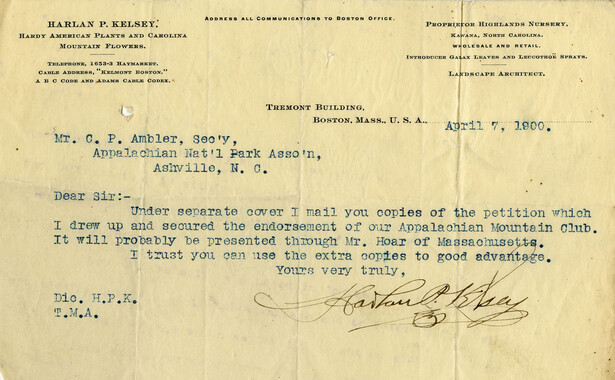
- Appalachian National Park Association (1)
- Bennett, Kelly, 1890-1974 (1048)
- Berry, Walter (42)
- Champion Fibre Company (1)
- Ensley, A. L. (Abraham Lincoln), 1865-1948 (1)
- Grant, George Alexander, 1891-1964 (19)
- Kephart, Horace, 1862-1931 (69)
- Kephart, Laura, 1862-1954 (2)
- Masa, George, 1881-1933 (6)
- North Carolina Park Commission (1)
- Roth, Albert, 1890-1974 (50)
- Sherrill's Photography Studio (23)
- Stearns, I. K. (181)
- USFS (3)
- Weaver, Zebulon, 1872-1948 (4)
- Wilburn, Hiram Coleman, 1880-1967 (3)
- Allanstand Cottage Industries (0)
- Brasstown Carvers (0)
- Cain, Doreyl Ammons (0)
- Carver, George Washington, 1864?-1943 (0)
- Cathey, Joseph, 1803-1874 (0)
- Champion Paper and Fibre Company (0)
- Cherokee Indian Fair Association (0)
- Cherokee Language Program (0)
- Crittenden, Lorraine (0)
- Crowe, Amanda (0)
- Edmonston, Thomas Benton, 1842-1907 (0)
- Fromer, Irving Rhodes, 1913-1994 (0)
- George Butz (BFS 1907) (0)
- Goodrich, Frances Louisa (0)
- Heard, Marian Gladys (0)
- Kephart, Calvin, 1883-1969 (0)
- Laney, Gideon Thomas, 1889-1976 (0)
- McElhinney, William Julian, 1896-1953 (0)
- Niggli, Josephina, 1910-1983 (0)
- Osborne, Kezia Stradley (0)
- Owens, Samuel Robert, 1918-1995 (0)
- Penland Weavers and Potters (0)
- Rhodes, Judy (0)
- Roberts, Vivienne (0)
- Schenck, Carl Alwin, 1868-1955 (0)
- Smith, Edward Clark (0)
- Southern Highland Handicraft Guild (0)
- Southern Highlanders, Inc. (0)
- Stalcup, Jesse Bryson (0)
- Thompson, James Edward, 1880-1976 (0)
- United States. Indian Arts and Crafts Board (0)
- Vance, Zebulon Baird, 1830-1894 (0)
- Western Carolina College (0)
- Western Carolina Teachers College (0)
- Western Carolina University (0)
- Western Carolina University. Mountain Heritage Center (0)
- Whitman, Walt, 1819-1892 (0)
- Williams, Isadora (0)
- 1870s (1)
- 1880s (2)
- 1890s (8)
- 1900s (38)
- 1910s (162)
- 1920s (676)
- 1930s (718)
- 1940s (356)
- 1950s (31)
- 1960s (8)
- 1970s (10)
- 1980s (4)
- 2000s (1)
- 2010s (1)
- 1600s (0)
- 1700s (0)
- 1800s (0)
- 1810s (0)
- 1820s (0)
- 1830s (0)
- 1840s (0)
- 1850s (0)
- 1860s (0)
- 1990s (0)
- 2020s (0)
- Appalachian Region, Southern (2393)
- Asheville (N.C.) (1887)
- Avery County (N.C.) (26)
- Blount County (Tenn.) (161)
- Buncombe County (N.C.) (1664)
- Cherokee County (N.C.) (283)
- Clay County (N.C.) (555)
- Graham County (N.C.) (233)
- Great Smoky Mountains National Park (N.C. and Tenn.) (478)
- Haywood County (N.C.) (3522)
- Henderson County (N.C.) (70)
- Jackson County (N.C.) (4692)
- Knox County (Tenn.) (25)
- Knoxville (Tenn.) (12)
- Lake Santeetlah (N.C.) (10)
- Macon County (N.C.) (420)
- Madison County (N.C.) (211)
- McDowell County (N.C.) (39)
- Mitchell County (N.C.) (132)
- Polk County (N.C.) (35)
- Qualla Boundary (981)
- Rutherford County (N.C.) (76)
- Swain County (N.C.) (2113)
- Transylvania County (N.C.) (247)
- Watauga County (N.C.) (12)
- Waynesville (N.C.) (68)
- Yancey County (N.C.) (72)
- Albums (books) (1)
- Clippings (information Artifacts) (36)
- Crafts (art Genres) (3)
- Depictions (visual Works) (2)
- Drawings (visual Works) (2)
- Envelopes (2)
- Facsimiles (reproductions) (1)
- Glass Plate Negatives (26)
- Interviews (122)
- Land Surveys (1)
- Letters (correspondence) (57)
- Manuscripts (documents) (65)
- Maps (documents) (23)
- Memorandums (4)
- Negatives (photographs) (1126)
- Newsletters (9)
- Photographs (433)
- Portraits (88)
- Postcards (20)
- Publications (documents) (18)
- Slides (photographs) (187)
- Sound Recordings (121)
- Specimens (3)
- Speeches (documents) (1)
- Transcripts (24)
- Aerial Photographs (0)
- Aerial Views (0)
- Articles (0)
- Artifacts (object Genre) (0)
- Biography (general Genre) (0)
- Cards (information Artifacts) (0)
- Design Drawings (0)
- Fiction (general Genre) (0)
- Financial Records (0)
- Fliers (printed Matter) (0)
- Guidebooks (0)
- Internegatives (0)
- Minutes (administrative Records) (0)
- Newspapers (0)
- Occupation Currency (0)
- Paintings (visual Works) (0)
- Pen And Ink Drawings (0)
- Periodicals (0)
- Personal Narratives (0)
- Plans (maps) (0)
- Poetry (0)
- Programs (documents) (0)
- Questionnaires (0)
- Scrapbooks (0)
- Sheet Music (0)
- Text Messages (0)
- Tintypes (photographs) (0)
- Video Recordings (physical Artifacts) (0)
- Vitreographs (0)
- A.L. Ensley Collection (1)
- Appalachian National Park Association Records (3)
- Canton Area Historical Museum (5)
- Carlos C. Campbell Collection (32)
- Cataloochee History Project (1)
- Frank Fry Collection (25)
- George Masa Collection (5)
- Hiram C. Wilburn Papers (3)
- Historic Photographs Collection (37)
- Horace Kephart Collection (146)
- Humbard Collection (33)
- John B. Battle Collection (3)
- Kelly Bennett Collection (1068)
- R.A. Romanes Collection (20)
- Sara Madison Collection (1)
- Sherrill Studio Photo Collection (23)
- Smoky Mountains Hiking Club Collection (210)
- Stories of Mountain Folk - Radio Programs (92)
- WCU Mountain Heritage Center Oral Histories (4)
- WCU Oral History Collection - Mountain People, Mountain Lives (5)
- Western North Carolina Tomorrow Black Oral History Project (13)
- Zebulon Weaver Collection (9)
- Appalachian Industrial School Records (0)
- Axley-Meroney Collection (0)
- Bayard Wootten Photograph Collection (0)
- Bethel Rural Community Organization Collection (0)
- Blumer Collection (0)
- C.W. Slagle Collection (0)
- Cherokee Studies Collection (0)
- Daisy Dame Photograph Album (0)
- Daniel Boone VI Collection (0)
- Doris Ulmann Photograph Collection (0)
- Elizabeth H. Lasley Collection (0)
- Elizabeth Woolworth Szold Fleharty Collection (0)
- Gideon Laney Collection (0)
- Hazel Scarborough Collection (0)
- Hunter and Weaver Families Collection (0)
- I. D. Blumenthal Collection (0)
- Isadora Williams Collection (0)
- Jesse Bryson Stalcup Collection (0)
- Jim Thompson Collection (0)
- John C. Campbell Folk School Records (0)
- John Parris Collection (0)
- Judaculla Rock project (0)
- Love Family Papers (0)
- Major Wiley Parris Civil War Letters (0)
- Map Collection (0)
- McFee-Misemer Civil War Letters (0)
- Mountain Heritage Center Collection (0)
- Norburn - Robertson - Thomson Families Collection (0)
- Pauline Hood Collection (0)
- Pre-Guild Collection (0)
- Qualla Arts and Crafts Mutual Collection (0)
- Rosser H. Taylor Collection (0)
- Samuel Robert Owens Collection (0)
- The Reporter, Western Carolina University (0)
- Venoy and Elizabeth Reed Collection (0)
- WCU Gender and Sexuality Oral History Project (0)
- WCU Students Newspapers Collection (0)
- William Williams Stringfield Collection (0)
- African Americans (32)
- Appalachian Trail (5)
- Artisans (20)
- Cherokee women (1)
- Church buildings (22)
- Civilian Conservation Corps (U.S.) (26)
- Dams (32)
- Floods (10)
- Folk music (2)
- Forest conservation (3)
- Forests and forestry (12)
- Great Smoky Mountains National Park (N.C. and Tenn.) (27)
- Hunting (4)
- Logging (1)
- Maps (13)
- Mines and mineral resources (4)
- Postcards (16)
- Railroad trains (5)
- Sports (2)
- Storytelling (62)
- Waterfalls -- Great Smoky Mountains (N.C. and Tenn.) (4)
- World War, 1939-1945 (20)
- Cherokee art (0)
- Cherokee artists -- North Carolina (0)
- Cherokee language (0)
- Cherokee pottery (0)
- College student newspapers and periodicals (0)
- Dance (0)
- Education (0)
- Forced removal, 1813-1903 (0)
- Gender nonconformity (0)
- Landscape photography (0)
- North Carolina -- Maps (0)
- Paper industry (0)
- Pottery (0)
- Rural electrification -- North Carolina, Western (0)
- School integration -- Southern States (0)
- Segregation -- North Carolina, Western (0)
- Slavery (0)
- Weaving -- Appalachian Region, Southern (0)
- Wood-carving -- Appalachian Region, Southern (0)
- Sound (121)
- StillImage (1823)
- Text (198)
- MovingImage (0)
Beginning of history in the Great Smoky Mountains


Beginning of history in the Great Smoky Mountains
GSMNP_10184_17_01_01
Beginning of history in the Great Smoky Mountains
GSMNP_10184_17_01_02
Beginning of history in the Great Smoky Mountains
GSMNP_10184_17_01_03
Beginning of history in the Great Smoky Mountains
GSMNP_10184_17_01_04
Beginning of history in the Great Smoky Mountains
GSMNP_10184_17_01_05
Beginning of history in the Great Smoky Mountains
GSMNP_10184_17_01_06
Beginning of history in the Great Smoky Mountains
GSMNP_10184_17_01_07
Beginning of history in the Great Smoky Mountains
GSMNP_10184_17_01_08
Beginning of history in the Great Smoky Mountains
GSMNP_10184_17_01_09
Beginning of history in the Great Smoky Mountains
GSMNP_10184_17_01_10_a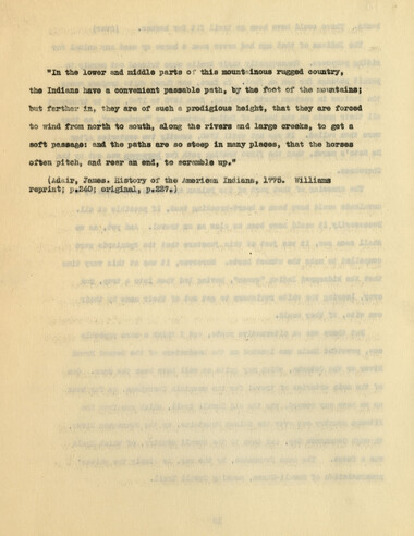
Beginning of history in the Great Smoky Mountains
GSMNP_10184_17_01_10_b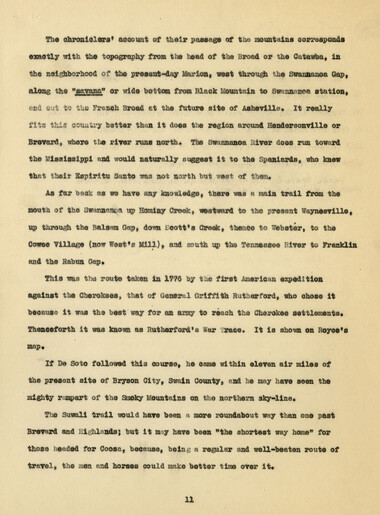
Beginning of history in the Great Smoky Mountains
GSMNP_10184_17_01_11
Beginning of history in the Great Smoky Mountains
GSMNP_10184_17_01_12
Beginning of history in the Great Smoky Mountains
GSMNP_10184_17_01_13
Beginning of history in the Great Smoky Mountains
GSMNP_10184_17_01_14Item’s are ‘child’ level descriptions to ‘parent’ objects, (e.g. one page of a whole book).
-
-
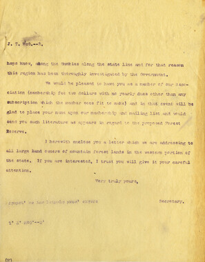
The chroniclers* account of their passage of the mountains corresponds exactly with the topography from the head of the Broad or the Catawba, in the neighborhood of the present-day Marion, west through the Swanaaaoa Gap, along the "sayana1* or wide ■ bottom from Black Mountain to Sweananoa statioa, and out to the French Broad et the future sit© of Asheville, It really fits lal| ccuuiiry better than it does the region around Hendersonville or Brevard, wher© the river runs north. The Swannanoa Hiver does run toward th© Mississippi and would naturally suggest it to the Spaniards, who knew that their Sspirltn Santo was not north but west, of them* As far back as we have any knowledge, there was a wain trail from the mouth of the swannanpa up Hoaiay Creek, westward to the present Waynesville, up through the Balsam Gap, dom Scott*s Creak, thence to Webster, to the Cowee Village (now W©st*s Mill), and south up the Tennessee River to Franklin and th© Rabun Gap* This was the rout© taken in 1776 by the first American expedition against the Cherokees, that of General Griffith Rutherford, who chose it because it was the best way for an army to reach the Cherokee settlements* Thenceforth it was known as Rutherford's War :race* It is shown en Royce'a If De Soto followed this course, he cam© within ©leven air miles of the present site of Bryson City, Swain County, and he may have seen th© mighty rtimpart of the Smoky Mountains on the northern sky-line. The Suwali trail would have been a more roundabout way than on© past Brevard and highlands; but it may have been "the shortest way home" for those headed for Coosa, because, being a regular and well-beaten route of travel, th© men and horses could make better time over it* 11
Object’s are ‘parent’ level descriptions to ‘children’ items, (e.g. a book with pages).
-
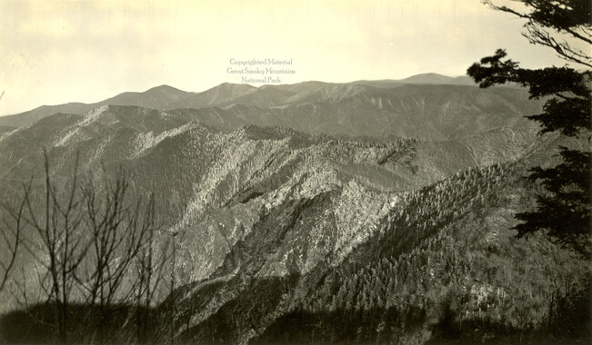
This “The Beginning of History in the Great Smoky Mountains National Park” was written by Horace Kephart and delivered as an address to the National Park Service in 1930. The history focuses on Hernando de Soto's route through the Southern Appalachians in the 16th century. Horace Kephart (1862-1931) was a noted naturalist, woodsman, journalist, and author and promoter of the Great Smoky Mountains National Park.
-


Part of Collection
Great Smoky Mountains - A Park for America