- Canton Champion Fibre Company (2308)
- Cherokee Traditions (291)
- Civil War in Southern Appalachia (165)
- Craft Revival (1942)
- Great Smoky Mountains - A Park for America (2857)
- Highlights from Western Carolina University (430)
- Horace Kephart (941)
- Journeys Through Jackson (154)
- LGBTQIA+ Archive of Jackson County (85)
- Oral Histories of Western North Carolina (314)
- Picturing Appalachia (6772)
- Stories of Mountain Folk (413)
- Travel Western North Carolina (160)
- Western Carolina University Fine Art Museum Vitreograph Collection (129)
- Western Carolina University Herbarium (92)
- Western Carolina University: Making Memories (708)
- Western Carolina University Publications (2353)
- Western Carolina University Restricted Electronic Theses and Dissertations (146)
- Western North Carolina Regional Maps (71)
- World War II in Southern Appalachia (131)
- Allanstand Cottage Industries (62)
- Appalachian National Park Association (53)
- Bennett, Kelly, 1890-1974 (1388)
- Berry, Walter (76)
- Brasstown Carvers (40)
- Carver, George Washington, 1864?-1943 (26)
- Cathey, Joseph, 1803-1874 (1)
- Champion Fibre Company (233)
- Champion Paper and Fibre Company (297)
- Cherokee Indian Fair Association (16)
- Cherokee Language Program (22)
- Crowe, Amanda (40)
- Edmonston, Thomas Benton, 1842-1907 (7)
- Ensley, A. L. (Abraham Lincoln), 1865-1948 (275)
- Fromer, Irving Rhodes, 1913-1994 (70)
- George Butz (BFS 1907) (46)
- Goodrich, Frances Louisa (120)
- Grant, George Alexander, 1891-1964 (96)
- Heard, Marian Gladys (60)
- Kephart, Calvin, 1883-1969 (15)
- Kephart, Horace, 1862-1931 (313)
- Kephart, Laura, 1862-1954 (39)
- Laney, Gideon Thomas, 1889-1976 (439)
- Masa, George, 1881-1933 (61)
- McElhinney, William Julian, 1896-1953 (44)
- Niggli, Josephina, 1910-1983 (10)
- North Carolina Park Commission (105)
- Osborne, Kezia Stradley (9)
- Owens, Samuel Robert, 1918-1995 (11)
- Penland Weavers and Potters (36)
- Roberts, Vivienne (15)
- Roth, Albert, 1890-1974 (142)
- Schenck, Carl Alwin, 1868-1955 (1)
- Sherrill's Photography Studio (2565)
- Southern Highland Handicraft Guild (127)
- Southern Highlanders, Inc. (71)
- Stalcup, Jesse Bryson (46)
- Stearns, I. K. (213)
- Thompson, James Edward, 1880-1976 (226)
- United States. Indian Arts and Crafts Board (130)
- USFS (683)
- Vance, Zebulon Baird, 1830-1894 (1)
- Weaver, Zebulon, 1872-1948 (58)
- Western Carolina College (230)
- Western Carolina Teachers College (282)
- Western Carolina University (1840)
- Western Carolina University. Mountain Heritage Center (18)
- Whitman, Walt, 1819-1892 (10)
- Wilburn, Hiram Coleman, 1880-1967 (73)
- Williams, Isadora (3)
- Cain, Doreyl Ammons (0)
- Crittenden, Lorraine (0)
- Rhodes, Judy (0)
- Smith, Edward Clark (0)
- Appalachian Region, Southern (2569)
- Asheville (N.C.) (1923)
- Avery County (N.C.) (26)
- Blount County (Tenn.) (169)
- Buncombe County (N.C.) (1672)
- Cherokee County (N.C.) (283)
- Clay County (N.C.) (555)
- Graham County (N.C.) (233)
- Great Smoky Mountains National Park (N.C. and Tenn.) (519)
- Haywood County (N.C.) (3567)
- Henderson County (N.C.) (70)
- Jackson County (N.C.) (4740)
- Knox County (Tenn.) (31)
- Knoxville (Tenn.) (12)
- Lake Santeetlah (N.C.) (10)
- Macon County (N.C.) (420)
- Madison County (N.C.) (215)
- McDowell County (N.C.) (39)
- Mitchell County (N.C.) (132)
- Polk County (N.C.) (35)
- Qualla Boundary (981)
- Rutherford County (N.C.) (76)
- Swain County (N.C.) (2117)
- Transylvania County (N.C.) (270)
- Watauga County (N.C.) (12)
- Waynesville (N.C.) (84)
- Yancey County (N.C.) (72)
- Aerial Photographs (3)
- Aerial Views (60)
- Albums (books) (4)
- Articles (1)
- Artifacts (object Genre) (228)
- Bibliographies (1)
- Biography (general Genre) (2)
- Cards (information Artifacts) (38)
- Clippings (information Artifacts) (191)
- Crafts (art Genres) (622)
- Depictions (visual Works) (21)
- Design Drawings (1)
- Drawings (visual Works) (184)
- Envelopes (73)
- Facsimiles (reproductions) (1)
- Fiction (general Genre) (4)
- Financial Records (12)
- Fliers (printed Matter) (67)
- Glass Plate Negatives (381)
- Guidebooks (2)
- Internegatives (10)
- Interviews (815)
- Land Surveys (102)
- Letters (correspondence) (1013)
- Manuscripts (documents) (618)
- Maps (documents) (177)
- Memorandums (25)
- Minutes (administrative Records) (59)
- Negatives (photographs) (5926)
- Newsletters (1285)
- Newspapers (2)
- Occupation Currency (1)
- Paintings (visual Works) (1)
- Pen And Ink Drawings (1)
- Periodicals (193)
- Personal Narratives (10)
- Photographs (12976)
- Plans (maps) (1)
- Poetry (5)
- Portraits (4535)
- Postcards (329)
- Programs (documents) (151)
- Publications (documents) (2305)
- Questionnaires (65)
- Scrapbooks (282)
- Sheet Music (2)
- Slides (photographs) (402)
- Songs (musical Compositions) (2)
- Sound Recordings (796)
- Specimens (92)
- Speeches (documents) (15)
- Tintypes (photographs) (8)
- Transcripts (322)
- Video Recordings (physical Artifacts) (23)
- Vitreographs (129)
- Text Messages (0)
- A.L. Ensley Collection (275)
- Appalachian Industrial School Records (7)
- Appalachian National Park Association Records (336)
- Axley-Meroney Collection (2)
- Bayard Wootten Photograph Collection (20)
- Bethel Rural Community Organization Collection (7)
- Blumer Collection (5)
- C.W. Slagle Collection (20)
- Canton Area Historical Museum (2110)
- Carlos C. Campbell Collection (373)
- Cataloochee History Project (64)
- Cherokee Studies Collection (4)
- Daisy Dame Photograph Album (5)
- Daniel Boone VI Collection (1)
- Doris Ulmann Photograph Collection (112)
- Elizabeth H. Lasley Collection (1)
- Elizabeth Woolworth Szold Fleharty Collection (4)
- Frank Fry Collection (95)
- George Masa Collection (173)
- Gideon Laney Collection (452)
- Hazel Scarborough Collection (2)
- Hiram C. Wilburn Papers (28)
- Historic Photographs Collection (236)
- Horace Kephart Collection (861)
- Humbard Collection (33)
- Hunter and Weaver Families Collection (1)
- I. D. Blumenthal Collection (4)
- Isadora Williams Collection (4)
- Jesse Bryson Stalcup Collection (47)
- Jim Thompson Collection (224)
- John B. Battle Collection (7)
- John C. Campbell Folk School Records (80)
- John Parris Collection (6)
- Judaculla Rock project (2)
- Kelly Bennett Collection (1407)
- Love Family Papers (11)
- Major Wiley Parris Civil War Letters (3)
- Map Collection (12)
- McFee-Misemer Civil War Letters (34)
- Mountain Heritage Center Collection (4)
- Norburn - Robertson - Thomson Families Collection (44)
- Pauline Hood Collection (7)
- Pre-Guild Collection (2)
- Qualla Arts and Crafts Mutual Collection (12)
- R.A. Romanes Collection (681)
- Rosser H. Taylor Collection (1)
- Samuel Robert Owens Collection (94)
- Sara Madison Collection (144)
- Sherrill Studio Photo Collection (2558)
- Smoky Mountains Hiking Club Collection (616)
- Stories of Mountain Folk - Radio Programs (374)
- The Reporter, Western Carolina University (510)
- Venoy and Elizabeth Reed Collection (16)
- WCU Gender and Sexuality Oral History Project (32)
- WCU Mountain Heritage Center Oral Histories (25)
- WCU Oral History Collection - Mountain People, Mountain Lives (71)
- WCU Students Newspapers Collection (1784)
- Western North Carolina Tomorrow Black Oral History Project (69)
- William Williams Stringfield Collection (2)
- Zebulon Weaver Collection (109)
- African Americans (390)
- Appalachian Trail (35)
- Artisans (521)
- Cherokee art (84)
- Cherokee artists -- North Carolina (10)
- Cherokee language (21)
- Cherokee pottery (101)
- Cherokee women (208)
- Church buildings (170)
- Civilian Conservation Corps (U.S.) (110)
- College student newspapers and periodicals (1876)
- Dams (107)
- Dance (1023)
- Education (222)
- Floods (61)
- Folk music (1015)
- Forced removal, 1813-1903 (2)
- Forest conservation (220)
- Forests and forestry (1184)
- Gender nonconformity (4)
- Great Smoky Mountains National Park (N.C. and Tenn.) (181)
- Hunting (45)
- Landscape photography (25)
- Logging (118)
- Maps (83)
- Mines and mineral resources (8)
- North Carolina -- Maps (18)
- Paper industry (38)
- Postcards (255)
- Pottery (135)
- Railroad trains (71)
- Rural electrification -- North Carolina, Western (3)
- School integration -- Southern States (2)
- Segregation -- North Carolina, Western (5)
- Slavery (5)
- Sports (452)
- Storytelling (243)
- Waterfalls -- Great Smoky Mountains (N.C. and Tenn.) (66)
- Weaving -- Appalachian Region, Southern (280)
- Wood-carving -- Appalachian Region, Southern (328)
- World War, 1939-1945 (173)
Secretary of Agriculture report on watersheds

Secretary of Agriculture report on watersheds
NCWRA_019_12_04_07_01
Secretary of Agriculture report on watersheds
NCWRA_019_12_04_07_02
Secretary of Agriculture report on watersheds
NCWRA_019_12_04_07_03
Secretary of Agriculture report on watersheds
NCWRA_019_12_04_07_04
Secretary of Agriculture report on watersheds
NCWRA_019_12_04_07_05
Secretary of Agriculture report on watersheds
NCWRA_019_12_04_07_06
Secretary of Agriculture report on watersheds
NCWRA_019_12_04_07_07
Secretary of Agriculture report on watersheds
NCWRA_019_12_04_07_08
Secretary of Agriculture report on watersheds
NCWRA_019_12_04_07_09
Secretary of Agriculture report on watersheds
NCWRA_019_12_04_07_10
Secretary of Agriculture report on watersheds
NCWRA_019_12_04_07_11
Secretary of Agriculture report on watersheds
NCWRA_019_12_04_07_12
Secretary of Agriculture report on watersheds
NCWRA_019_12_04_07_13
Secretary of Agriculture report on watersheds
NCWRA_019_12_04_07_14
Secretary of Agriculture report on watersheds
NCWRA_019_12_04_07_15
Secretary of Agriculture report on watersheds
NCWRA_019_12_04_07_16
Secretary of Agriculture report on watersheds
NCWRA_019_12_04_07_17
Secretary of Agriculture report on watersheds
NCWRA_019_12_04_07_18
Secretary of Agriculture report on watersheds
NCWRA_019_12_04_07_19
Secretary of Agriculture report on watersheds
NCWRA_019_12_04_07_20
Secretary of Agriculture report on watersheds
NCWRA_019_12_04_07_21
Secretary of Agriculture report on watersheds
NCWRA_019_12_04_07_22
Secretary of Agriculture report on watersheds
NCWRA_019_12_04_07_23
Secretary of Agriculture report on watersheds
NCWRA_019_12_04_07_24
Secretary of Agriculture report on watersheds
NCWRA_019_12_04_07_25
Secretary of Agriculture report on watersheds
NCWRA_019_12_04_07_26
Secretary of Agriculture report on watersheds
NCWRA_019_12_04_07_27
Secretary of Agriculture report on watersheds
NCWRA_019_12_04_07_28
Secretary of Agriculture report on watersheds
NCWRA_019_12_04_07_29
Secretary of Agriculture report on watersheds
NCWRA_019_12_04_07_30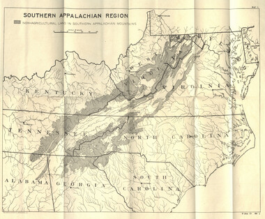
Secretary of Agriculture report on watersheds
NCWRA_019_12_04_07_30a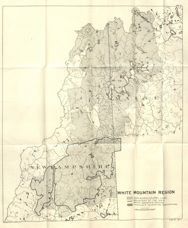
Secretary of Agriculture report on watersheds
NCWRA_019_12_04_07_30b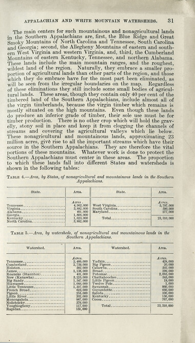
Secretary of Agriculture report on watersheds
NCWRA_019_12_04_07_31
Secretary of Agriculture report on watersheds
NCWRA_019_12_04_07_32
Secretary of Agriculture report on watersheds
NCWRA_019_12_04_07_33
Secretary of Agriculture report on watersheds
NCWRA_019_12_04_07_34
Secretary of Agriculture report on watersheds
NCWRA_019_12_04_07_35
Secretary of Agriculture report on watersheds
NCWRA_019_12_04_07_36
Secretary of Agriculture report on watersheds
NCWRA_019_12_04_07_37
Secretary of Agriculture report on watersheds
NCWRA_019_12_04_07_38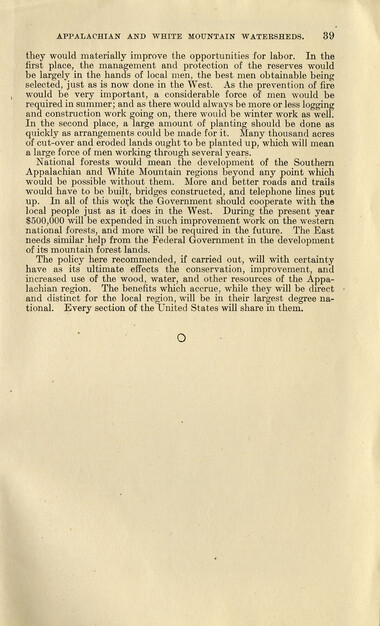
Secretary of Agriculture report on watersheds
NCWRA_019_12_04_07_39Item’s are ‘child’ level descriptions to ‘parent’ objects, (e.g. one page of a whole book).
-
-
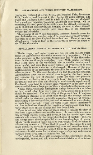
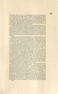
16 APPALACHIAN AND WHITE MOUNTAIN WATERSHEDS. coggin are centered at Berlin, N. H., and Rumford Falls, Livermore Falls, Lewiston, and Brunswick, Me. In the 167 miles between tide , water and Umbagog Lake there is a fall of 1,235 feet, of which 610 feet is used, corresponding to about 120,000 net horsepower. Of the remaining 625 feet, possibly two-thirds can be utilized, corresponding to 60,000 net horsepower, and bringing the total to about 180,000 horsepower, or approximately three times that of the Merrimac without its tributaries. The streams of the White Mountains, therefore, furnish power for great industries, and are the basis of development for many prosperous cities in all the New England States but one. These streams are all influenced vitally in flow by the forest which covers the slopes of the White Mountains. APPALACHIAN MOUNTAINS IMPORTANT TO NAVIGATION. Timber supply and water power are not the only factors which make the Appalachian Mountains commercially important. All the water gathered by the Southern Appalachian and White Mountains flows to the sea through navigable rivers. With greater elevation than other parts of the watersheds the mountains receive much more rainfall, and with their cooler climate the evaporation is less; hence there is more water to be discharged. Because of the precipitous slopes of the mountains the run-off is far more rapid than in other sections. To this must be added the fact that in the Southern Appalachians there are no natural lakes to gather the flood waters and equalize the flow of streams. There are thus two powerful influences contributing to an extremely heavy discharge from these mountains, and two more contributing to an extremely rapid run-off. Combined, these tend to produce great variability in the flow of all streams which have a large part of their watersheds in the mountains. A large regular discharge coming from springs is desirable, a variable surface run-off is bad from every point of view, and so far as possible should be remedied. The variability of the present flow of Southern Appalachian streams is so great that though the average volume would make the streams constantly navigable, they are at extreme flood during a few weeks of the year and at extreme low water during a much longer period. Their low-water stage causes interference and loss to business through the cessation of navigation; their high- water stage often entails damage and loss from floods. There is but one natural factor which tends to equalize the flow of Southern Appalachian streams—the forest. In one continuous mantle, covering ridges, slopes, and coves, it has for untold ages been nature's sole reliance for the proper distribution of rainfall. If storm and deluge came, the downpour fell upon a foot-deep layer of humus, which readily received many times its own weight of water before it allowed any to escape. When filled, it passed on the excess to a soil made porous by myriads of penetrating roots and countless tons of vegetable mold. If drought came, it found the humus and soil filled as a reservoir with water for the steady supply of springs and streams through weeks or months of rainless weather. The original forest, then, with its characteristic conditions of shade, undergrowth, humus, and soil, was an effectual distributer of moisture.
Object’s are ‘parent’ level descriptions to ‘children’ items, (e.g. a book with pages).
-
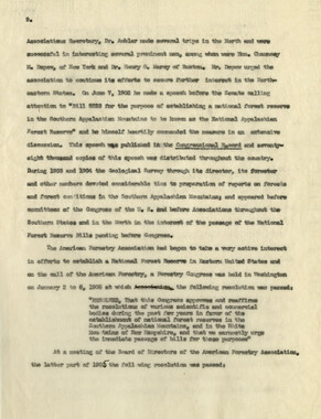
This 41-page “Report of the Secretary of Agriculture on The Southern Appalachian and White Mountain Watersheds” is in the collection of the Appalachian National Park Association records. The Senate report was written in 1907. Even before the dawn of the 20th century, the association raised awareness of the importance of forests to water.
-
Related items
-
Western Carolinian Volume 71 Number 05

-
Western Carolinian Volume 41 Number 05
-
Western Carolinian Volume 44 Number 04
-
Western Carolinian Volume 51 Number 03
-
Western Carolinian Volume 60 Number 01
-
Western Carolinian Volume 44 Number 14
-
Western Carolinian Volume 26 Number 04
-
Western Carolinian Volume 03 Number 09
-
Western Carolinian Volume 38 Number 32
-
Western Carolinian Volume 62 (63) Number 16

-
Western Carolinian Volume 46 Number 10, October 29, 1981
-
Western Carolinian Volume 39 Number 52

-
Western Carolinian Volume 34 Number 39
-
Western Carolinian Volume 25 Number 05
-
Western Carolinian Volume 65 (66) Number 04
-
Western Carolinian Volume 56 Number 02
-
Western Carolinian Volume 40 Number 38 (39)
-
Western Carolinian Volume 61 Number 06 (07)
-
Western Carolinian Volume 54 Number 16
-
Western Carolinian Volume 65 (66) Number 14

-
Constitution and Laws of the Cherokee Nation

-
Western Carolinian Volume 07 50th Anniversary
-
Western Carolinian Volume 62 Number 23

-
Western Carolinian Volume 62 Number 24

-
Western Carolinian Volume 54 Number 24
-
Western Carolinian Volume 58 Number 14

-
Olive Dame Campbell Memorial Issue of Mountain Life & Work, Number 4, 1954

-
Western Carolinian Volume 49 Number 24, March 7, 1985

-
Western Carolinian Volume 57 Number 06

-
Western Carolinian Volume 35 Number 18
-
Western Carolinian Volume 59 Number 05

-
The Canton Enterprise Volume 44 Number 27 Section 01

Part of Collection
Great Smoky Mountains - A Park for America
-
Tri-Corner Knob from Mount Guyot

-
Complete Report Submitted to Governor Clyde R. Hoey
-
Marshall Wilson, Harvey Broome, and Lucien Green at their camp
-
Rainbow Falls - Rocky Spur Trail

-
Correspondence between Zebulon Weaver and Andrew Gennett, 1925-1926
-
Great Smoky Mountains

-
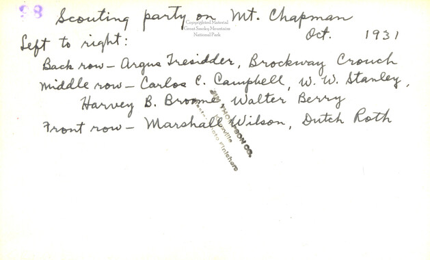
Scouting Party on Mount Chapman
-
Mountain peaks in the Great Smoky Mountains
-
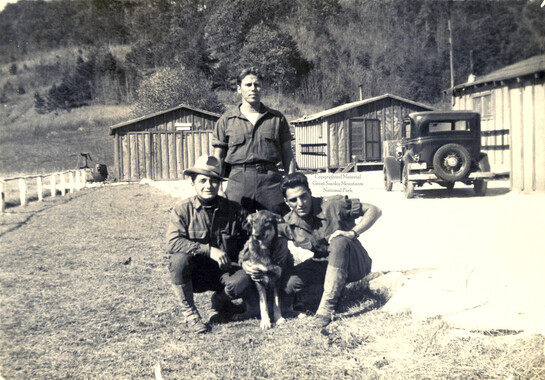
CCC enrollees
-
How to Reach our New National Park in the Great Smoky Mountains

-
Cataloochee tract 234: J. W. Burgess

-
Correspondence regarding the destruction of United States forests

-
Unaka and the Pisgah

-
Cataloochee tract 254: W. D. Messer

-
Secretary of Agriculture report on watersheds
-
Great Smoky Mountains National Park, North Carolina- Tennessee

-
Hikers on Mount Guyot
-
Appalachian National Park: Synopsis of work accomplished

-
Cataloochee tract 201: J. L. Caldwell

-
Mountain laurel thicket

-
Appalachian National Park Association Newspaper Clippings, 1899-1902
-
Weeks Law Silver Jubilee
-
Financial receipts and expenditures, 1901
-
Report of the Secretary of Agriculture in relation to the forests, rivers, and mountains of the southern Appalachian region

-
Program of hikes for 1930/ Smoky Mountains Hiking Club

-
Why Should We Study Forestry?
-
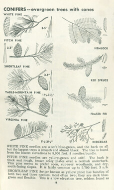
Trees of the Great Smoky Mountains National Park
-
CCC camp at Sugarlands, Company 1459
-
CCC enrollee at Camp NP-4 near Smokemont, N.C.
-
Nomenclature notes: place names in N. C.

-
Map of Mount Leconte

-
Nomenclature notes: place names in Smokies