- Canton Champion Fibre Company (2308)
- Cherokee Traditions (291)
- Civil War in Southern Appalachia (165)
- Craft Revival (1942)
- George Masa Collection (137)
- Great Smoky Mountains - A Park for America (2900)
- Highlights from Western Carolina University (422)
- Horace Kephart (941)
- Journeys Through Jackson (159)
- LGBTQIA+ Archive of Jackson County (85)
- Oral Histories of Western North Carolina (314)
- Picturing Appalachia (6797)
- Stories of Mountain Folk (413)
- Travel Western North Carolina (153)
- Western Carolina University Fine Art Museum Vitreograph Collection (129)
- Western Carolina University Herbarium (92)
- Western Carolina University: Making Memories (738)
- Western Carolina University Publications (2491)
- Western Carolina University Restricted Electronic Theses and Dissertations (146)
- Western North Carolina Regional Maps (71)
- World War II in Southern Appalachia (131)
- Allanstand Cottage Industries (62)
- Appalachian National Park Association (53)
- Bennett, Kelly, 1890-1974 (1463)
- Berry, Walter (76)
- Brasstown Carvers (40)
- Carver, George Washington, 1864?-1943 (26)
- Cathey, Joseph, 1803-1874 (1)
- Champion Fibre Company (233)
- Champion Paper and Fibre Company (297)
- Cherokee Indian Fair Association (16)
- Cherokee Language Program (22)
- Crowe, Amanda (40)
- Edmonston, Thomas Benton, 1842-1907 (7)
- Ensley, A. L. (Abraham Lincoln), 1865-1948 (275)
- Fromer, Irving Rhodes, 1913-1994 (70)
- George Butz (BFS 1907) (46)
- Goodrich, Frances Louisa (120)
- Grant, George Alexander, 1891-1964 (96)
- Heard, Marian Gladys (60)
- Kephart, Calvin, 1883-1969 (15)
- Kephart, Horace, 1862-1931 (313)
- Kephart, Laura, 1862-1954 (39)
- Laney, Gideon Thomas, 1889-1976 (439)
- Masa, George, 1881-1933 (61)
- McElhinney, William Julian, 1896-1953 (44)
- Niggli, Josephina, 1910-1983 (10)
- North Carolina Park Commission (105)
- Osborne, Kezia Stradley (9)
- Owens, Samuel Robert, 1918-1995 (11)
- Penland Weavers and Potters (36)
- Roberts, Vivienne (15)
- Roth, Albert, 1890-1974 (142)
- Schenck, Carl Alwin, 1868-1955 (1)
- Sherrill's Photography Studio (2565)
- Southern Highland Handicraft Guild (127)
- Southern Highlanders, Inc. (71)
- Stalcup, Jesse Bryson (46)
- Stearns, I. K. (213)
- Thompson, James Edward, 1880-1976 (226)
- United States. Indian Arts and Crafts Board (130)
- USFS (683)
- Vance, Zebulon Baird, 1830-1894 (1)
- Weaver, Zebulon, 1872-1948 (58)
- Western Carolina College (230)
- Western Carolina Teachers College (282)
- Western Carolina University (2008)
- Western Carolina University. Mountain Heritage Center (18)
- Whitman, Walt, 1819-1892 (10)
- Wilburn, Hiram Coleman, 1880-1967 (73)
- Williams, Isadora (3)
- Cain, Doreyl Ammons (0)
- Crittenden, Lorraine (0)
- Rhodes, Judy (0)
- Smith, Edward Clark (0)
- Appalachian Region, Southern (2929)
- Asheville (N.C.) (1944)
- Avery County (N.C.) (26)
- Blount County (Tenn.) (195)
- Buncombe County (N.C.) (1680)
- Cherokee County (N.C.) (283)
- Clay County (N.C.) (556)
- Graham County (N.C.) (238)
- Great Smoky Mountains National Park (N.C. and Tenn.) (525)
- Haywood County (N.C.) (3571)
- Henderson County (N.C.) (70)
- Jackson County (N.C.) (4917)
- Knox County (Tenn.) (35)
- Knoxville (Tenn.) (13)
- Lake Santeetlah (N.C.) (10)
- Macon County (N.C.) (420)
- Madison County (N.C.) (216)
- McDowell County (N.C.) (39)
- Mitchell County (N.C.) (135)
- Polk County (N.C.) (35)
- Qualla Boundary (982)
- Rutherford County (N.C.) (78)
- Swain County (N.C.) (2185)
- Transylvania County (N.C.) (270)
- Watauga County (N.C.) (12)
- Waynesville (N.C.) (86)
- Yancey County (N.C.) (72)
- Aerial Photographs (3)
- Aerial Views (60)
- Albums (books) (4)
- Articles (1)
- Artifacts (object Genre) (228)
- Bibliographies (1)
- Biography (general Genre) (2)
- Cards (information Artifacts) (38)
- Clippings (information Artifacts) (191)
- Copybooks (instructional Materials) (3)
- Crafts (art Genres) (622)
- Depictions (visual Works) (21)
- Design Drawings (1)
- Drawings (visual Works) (185)
- Envelopes (73)
- Exhibitions (events) (1)
- Facsimiles (reproductions) (1)
- Fiction (general Genre) (4)
- Financial Records (12)
- Fliers (printed Matter) (67)
- Glass Plate Negatives (381)
- Guidebooks (2)
- Internegatives (10)
- Interviews (815)
- Land Surveys (102)
- Letters (correspondence) (1013)
- Manuscripts (documents) (618)
- Maps (documents) (177)
- Memorandums (25)
- Minutes (administrative Records) (59)
- Negatives (photographs) (6090)
- Newsletters (1290)
- Newspapers (2)
- Notebooks (8)
- Occupation Currency (1)
- Paintings (visual Works) (1)
- Pen And Ink Drawings (1)
- Periodicals (193)
- Personal Narratives (10)
- Photographs (12976)
- Plans (maps) (1)
- Poetry (5)
- Portraits (4568)
- Postcards (329)
- Programs (documents) (181)
- Publications (documents) (2443)
- Questionnaires (65)
- Relief Prints (26)
- Sayings (literary Genre) (1)
- Scrapbooks (282)
- Sheet Music (2)
- Slides (photographs) (402)
- Songs (musical Compositions) (2)
- Sound Recordings (796)
- Specimens (92)
- Speeches (documents) (18)
- Tintypes (photographs) (8)
- Transcripts (322)
- Video Recordings (physical Artifacts) (23)
- Text Messages (0)
- A.L. Ensley Collection (275)
- Appalachian Industrial School Records (7)
- Appalachian National Park Association Records (336)
- Axley-Meroney Collection (2)
- Bayard Wootten Photograph Collection (20)
- Bethel Rural Community Organization Collection (7)
- Blumer Collection (5)
- C.W. Slagle Collection (20)
- Canton Area Historical Museum (2110)
- Carlos C. Campbell Collection (462)
- Cataloochee History Project (64)
- Cherokee Studies Collection (4)
- Daisy Dame Photograph Album (5)
- Daniel Boone VI Collection (1)
- Doris Ulmann Photograph Collection (112)
- Elizabeth H. Lasley Collection (1)
- Elizabeth Woolworth Szold Fleharty Collection (4)
- Frank Fry Collection (95)
- George Masa Collection (173)
- Gideon Laney Collection (452)
- Hazel Scarborough Collection (2)
- Hiram C. Wilburn Papers (28)
- Historic Photographs Collection (236)
- Horace Kephart Collection (861)
- Humbard Collection (33)
- Hunter and Weaver Families Collection (1)
- I. D. Blumenthal Collection (4)
- Isadora Williams Collection (4)
- Jesse Bryson Stalcup Collection (47)
- Jim Thompson Collection (224)
- John B. Battle Collection (7)
- John C. Campbell Folk School Records (80)
- John Parris Collection (6)
- Judaculla Rock project (2)
- Kelly Bennett Collection (1482)
- Love Family Papers (11)
- Major Wiley Parris Civil War Letters (3)
- Map Collection (12)
- McFee-Misemer Civil War Letters (34)
- Mountain Heritage Center Collection (4)
- Norburn - Robertson - Thomson Families Collection (44)
- Pauline Hood Collection (7)
- Pre-Guild Collection (2)
- Qualla Arts and Crafts Mutual Collection (12)
- R.A. Romanes Collection (681)
- Rosser H. Taylor Collection (1)
- Samuel Robert Owens Collection (94)
- Sara Madison Collection (144)
- Sherrill Studio Photo Collection (2558)
- Smoky Mountains Hiking Club Collection (616)
- Stories of Mountain Folk - Radio Programs (374)
- The Reporter, Western Carolina University (510)
- Venoy and Elizabeth Reed Collection (16)
- WCU Gender and Sexuality Oral History Project (32)
- WCU Mountain Heritage Center Oral Histories (25)
- WCU Oral History Collection - Mountain People, Mountain Lives (71)
- WCU Students Newspapers Collection (1923)
- Western North Carolina Tomorrow Black Oral History Project (69)
- William Williams Stringfield Collection (2)
- Zebulon Weaver Collection (109)
- African Americans (390)
- Appalachian Trail (35)
- Artisans (521)
- Cherokee art (84)
- Cherokee artists -- North Carolina (10)
- Cherokee language (21)
- Cherokee pottery (101)
- Cherokee women (208)
- Church buildings (190)
- Civilian Conservation Corps (U.S.) (111)
- College student newspapers and periodicals (2012)
- Dams (108)
- Dance (1023)
- Education (222)
- Floods (61)
- Folk music (1015)
- Forced removal, 1813-1903 (2)
- Forest conservation (220)
- Forests and forestry (1196)
- Gender nonconformity (4)
- Great Smoky Mountains National Park (N.C. and Tenn.) (181)
- Hunting (46)
- Landscape photography (25)
- Logging (119)
- Maps (83)
- Mines and mineral resources (9)
- North Carolina -- Maps (18)
- Paper industry (38)
- Postcards (255)
- Pottery (135)
- Railroad trains (72)
- Rural electrification -- North Carolina, Western (3)
- School integration -- Southern States (2)
- Segregation -- North Carolina, Western (5)
- Slavery (5)
- Sports (452)
- Storytelling (243)
- Waterfalls -- Great Smoky Mountains (N.C. and Tenn.) (66)
- Weaving -- Appalachian Region, Southern (280)
- Wood-carving -- Appalachian Region, Southern (328)
- World War, 1939-1945 (173)
Secretary of Agriculture report on watersheds

Secretary of Agriculture report on watersheds
NCWRA_019_12_04_07_01
Secretary of Agriculture report on watersheds
NCWRA_019_12_04_07_02
Secretary of Agriculture report on watersheds
NCWRA_019_12_04_07_03
Secretary of Agriculture report on watersheds
NCWRA_019_12_04_07_04
Secretary of Agriculture report on watersheds
NCWRA_019_12_04_07_05
Secretary of Agriculture report on watersheds
NCWRA_019_12_04_07_06
Secretary of Agriculture report on watersheds
NCWRA_019_12_04_07_07
Secretary of Agriculture report on watersheds
NCWRA_019_12_04_07_08
Secretary of Agriculture report on watersheds
NCWRA_019_12_04_07_09
Secretary of Agriculture report on watersheds
NCWRA_019_12_04_07_10
Secretary of Agriculture report on watersheds
NCWRA_019_12_04_07_11
Secretary of Agriculture report on watersheds
NCWRA_019_12_04_07_12
Secretary of Agriculture report on watersheds
NCWRA_019_12_04_07_13
Secretary of Agriculture report on watersheds
NCWRA_019_12_04_07_14
Secretary of Agriculture report on watersheds
NCWRA_019_12_04_07_15
Secretary of Agriculture report on watersheds
NCWRA_019_12_04_07_16
Secretary of Agriculture report on watersheds
NCWRA_019_12_04_07_17
Secretary of Agriculture report on watersheds
NCWRA_019_12_04_07_18
Secretary of Agriculture report on watersheds
NCWRA_019_12_04_07_19
Secretary of Agriculture report on watersheds
NCWRA_019_12_04_07_20
Secretary of Agriculture report on watersheds
NCWRA_019_12_04_07_21
Secretary of Agriculture report on watersheds
NCWRA_019_12_04_07_22
Secretary of Agriculture report on watersheds
NCWRA_019_12_04_07_23
Secretary of Agriculture report on watersheds
NCWRA_019_12_04_07_24
Secretary of Agriculture report on watersheds
NCWRA_019_12_04_07_25
Secretary of Agriculture report on watersheds
NCWRA_019_12_04_07_26
Secretary of Agriculture report on watersheds
NCWRA_019_12_04_07_27
Secretary of Agriculture report on watersheds
NCWRA_019_12_04_07_28
Secretary of Agriculture report on watersheds
NCWRA_019_12_04_07_29
Secretary of Agriculture report on watersheds
NCWRA_019_12_04_07_30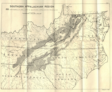
Secretary of Agriculture report on watersheds
NCWRA_019_12_04_07_30a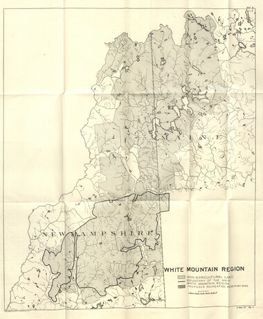
Secretary of Agriculture report on watersheds
NCWRA_019_12_04_07_30b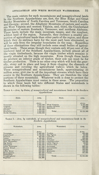
Secretary of Agriculture report on watersheds
NCWRA_019_12_04_07_31
Secretary of Agriculture report on watersheds
NCWRA_019_12_04_07_32
Secretary of Agriculture report on watersheds
NCWRA_019_12_04_07_33
Secretary of Agriculture report on watersheds
NCWRA_019_12_04_07_34
Secretary of Agriculture report on watersheds
NCWRA_019_12_04_07_35
Secretary of Agriculture report on watersheds
NCWRA_019_12_04_07_36
Secretary of Agriculture report on watersheds
NCWRA_019_12_04_07_37
Secretary of Agriculture report on watersheds
NCWRA_019_12_04_07_38
Secretary of Agriculture report on watersheds
NCWRA_019_12_04_07_39Item’s are ‘child’ level descriptions to ‘parent’ objects, (e.g. one page of a whole book).
-
-
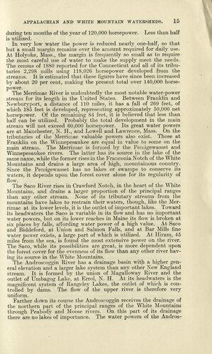
APPALACHIAN AND WHITE MOUNTAIN WATERSHEDS. 15 during ten months of the year of 120,000 horsepower. Less than half is utilized. In very low water the power is reduced nearly one-half, so that but a small margin remains over the amount required for daily use. At Holyoke, Mass., the margin is frequently so small as to require the most careful use of water to make the supply meet the needs. The census of 1880 reported for the Connecticut and all of its tributaries 2,298 mills using 118,026 horsepower developed from the streams. It is estimated that these figures have since been increased by about 20 per cent, making the present total over 140,000 horsepower. The Merrimac River is undoubtedly the most notable water-power stream for its length in the United States. Between Franklin and Newburyport, a distance of 110 miles, it has a fall of 269 feet, of which 185 feet is developed, representing approximately 50,000 net horsepower. Of the remaining 84 feet, it is believed that less than half can be utilized. Probably the total development in the main stream will not exceed 60,000 horsepower. Its great water powers are at Manchester, N. H., and Lowell and Lawrence, Mass. On the tributaries of the Merrimac valuable powers also exist. Those at Franklin on the Wiimepesaukee are equal in value to some on the main stream. The Merrimac is formed by the Pemigewasset and Winnepesaukee rivers. The latter has its source in the lake of the same name, while the former rises in the Franconia Notch of the White Mountains and drains a large area of high, mountainous country. Since the Pemigewasset has no lakes or swamps to conserve its waters, it depends upon the forest cover alone for its regularity of flow. The Saco River rises in Crawford Notch, in the heart of the White Mountains, and drains a larger proportion of the principal ranges than any other stream. None of its tributary streams from the mountains have lakes to restrain their waters, though, like the Merrimac at its lower levels, it is the outlet of important lakes. Toward its headwaters the Saco is variable in its flow and has no important water powers, but on its lower reaches in Maine its flow is broken at six places by falls, affording water power of a high value. At Saco and Biddeford, at Union and Salmon Falls, and at Bar Mills fine water power exists, a large part of which is utilized. At Hiram, 45 miles from the sea, is found the most extensive power on the river. The Saco, while its possibilities are great, is more dependent upon the forest cover for the evenness of its flow than any other river having its source in the White Mountains. The Androscoggin River has a drainage basin with a higher general elevation and a larger lake system than any other New England stream. It is formed by the union of Magalloway River and the outlet of Umbagog Lake, at Errol, N. H. At its headwaters is the magnificent system of Rangeley Lakes, the outlet of which is controlled by dams. The flow of the upper river is therefore very uniform. Farther down its course the Androscoggin receives the drainage of the northern part of the principal ranges of the White Mountains through Peabody and Moose rivers. On this part of its drainage there are no lakes of importance. The water powers of the Andros-
Object’s are ‘parent’ level descriptions to ‘children’ items, (e.g. a book with pages).
-
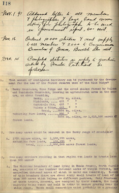
This 41-page “Report of the Secretary of Agriculture on The Southern Appalachian and White Mountain Watersheds” is in the collection of the Appalachian National Park Association records. The Senate report was written in 1907. Even before the dawn of the 20th century, the association raised awareness of the importance of forests to water.
-
Related items
-
Western Carolinian Volume 64 (65) Number 27
-
Western Carolinian Volume 09 February 19, 1941
-
Documentary of Six Cherokee Artists
-
Western Carolinian Volume 87 Number 01
-
Western Carolinian Volume 42 Number 61
-
Western Carolinian Volume 62 Number 05
-
Western Carolinian Volume 21 Number 09
-
Western Carolinian Volume 42 Number 52
-
The Canton Enterprise Volume 22 Number 29

-
Western Carolinian Volume 54 Number 02
-
Cherokee Indian Fair 1946

-
Report of the Secretary of Agriculture in relation to the forests, rivers, and mountains of the southern Appalachian region
-
Neo-Blackness 1977
-
Western Carolinian Volume 55 Number 01
-
Western Carolinian Volume 34 Number 30
-
Western Carolinian Volume 59 Number 26 (25)

-
Western Carolinian Volume 48 Number 12
-
Cullowhee Yodel Volume 04 Number 02

-
Western Carolinian Volume 58 Number 22

-
Western Carolinian Volume 40 Number 16
-
Western Carolinian Volume 70 Number 03

-
Western Carolinian Volume 10 Number 05
-
Western Carolinian Volume 52 Number 07
-
Neo-Blackness 1980

-
Western Carolinian Volume 39 Number 20
-
Western Carolinian Volume 73 Number 05
-
Western Carolinian Volume 64 (65) Number 27
-
Western Carolinian Volume 14 Number 01
-
Western Carolinian Volume 63 (64) Number 11

-
Western Carolinian Volume 43 Number 06
-
Western Carolinian Volume 50 Number 10
-
Western Carolinian Volume 17 Number 05
Part of Collection
Great Smoky Mountains - A Park for America
-
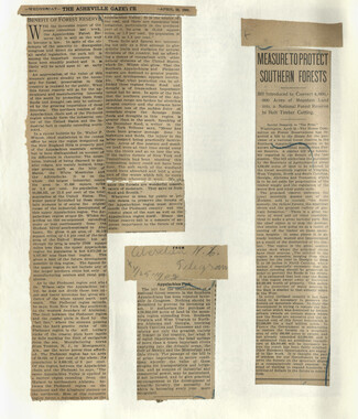
Appalachian National Park Association Newspaper Clippings, 1902-1907, 1925, 1928

-
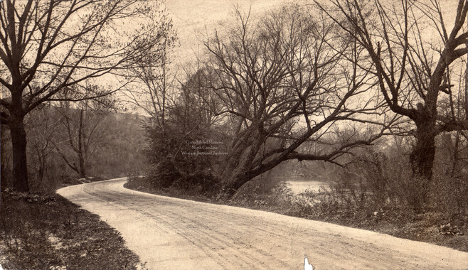
Swannanoa River and drive near Asheville
-
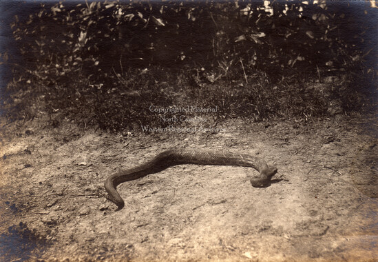
Rattlesnake
-
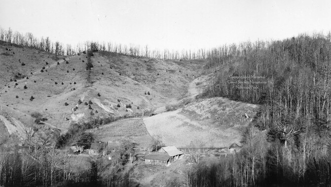
Cataloochee tract 201a: J. L. Caldwell
-
Climatic Treatment of Disease: Western North Carolina as a Health Resort

-
Financial record of Cash Receipts and Expenditures

-
Legislation Secured by the Appalachian National Park Association
-
Cataloochee tract 215: George H. Caldwell
-
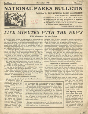
National Parks Bulletin, 1925
-
Great Smokies

-
Study for the Preservation of Mountain Culture in Field Museum of History

-
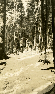
Rocky Spur Trail to Mount LeConte
-
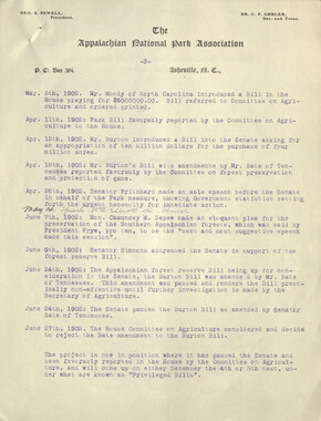
Minutes of Meetings of the Appalachian National Park Association
-
Waterfall at Huggins Hell

-
Appalachian National Park Association Newspaper Clippings, 1899-1902
-
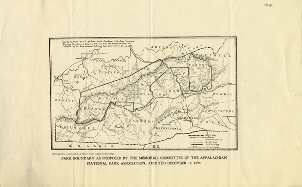
Memorial to the Congress of the United States
-
Minutes of Meetings of the Appalachian National Park Association

-
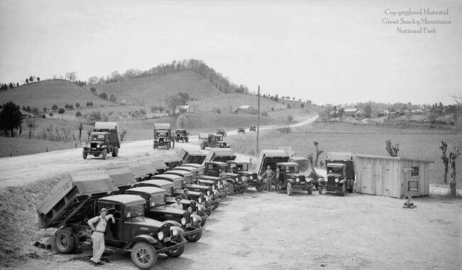
Fleet of International Heavy-Duty trucks
-
Penstock at Rymers Ferry

-
CCC Camp NP-10 near Sevierville, Tenn.
-
Mag Caldwell
-
Correspondence: Chase Ambler to state geologist, December 1900

-
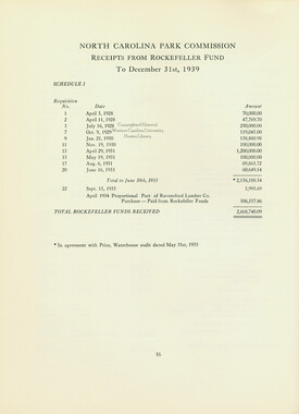
Report of the North Carolina Park Commission
-
Financial receipts and expenditures, 1900
-
Roaring fork
-
Minutes of Meetings of the Appalachian National Park Association
-
Travel and banquet in Washington D.C.

-
Appalachian National Park Association Newspaper Clippings, 1899-1902
-
House of Representatives delegate list
-
Senate 5518 report
-
Appalachian National Park Association Newspaper Clippings, 1902-1907, 1925, 1928
-
Nomenclature notebook: N.C. portion/ Great Smoky Mountains National Park