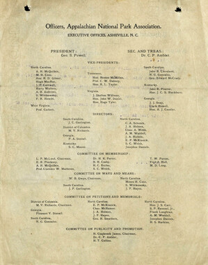
- Canton Champion Fibre Company (2308)
- Cherokee Traditions (291)
- Civil War in Southern Appalachia (165)
- Craft Revival (1942)
- George Masa Collection (137)
- Great Smoky Mountains - A Park for America (2900)
- Highlights from Western Carolina University (422)
- Horace Kephart (941)
- Journeys Through Jackson (159)
- LGBTQIA+ Archive of Jackson County (85)
- Oral Histories of Western North Carolina (314)
- Picturing Appalachia (6797)
- Stories of Mountain Folk (413)
- Travel Western North Carolina (153)
- Western Carolina University Fine Art Museum Vitreograph Collection (129)
- Western Carolina University Herbarium (92)
- Western Carolina University: Making Memories (738)
- Western Carolina University Publications (2491)
- Western Carolina University Restricted Electronic Theses and Dissertations (146)
- Western North Carolina Regional Maps (71)
- World War II in Southern Appalachia (131)
- Allanstand Cottage Industries (62)
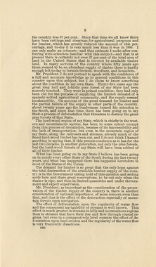
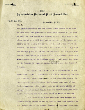
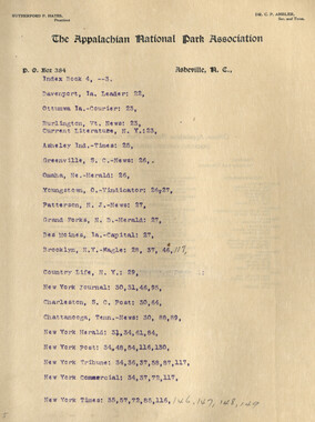
- Appalachian National Park Association (53)
- Bennett, Kelly, 1890-1974 (1463)
- Berry, Walter (76)
- Brasstown Carvers (40)
- Carver, George Washington, 1864?-1943 (26)
- Cathey, Joseph, 1803-1874 (1)
- Champion Fibre Company (233)
- Champion Paper and Fibre Company (297)
- Cherokee Indian Fair Association (16)
- Cherokee Language Program (22)
- Crowe, Amanda (40)
- Edmonston, Thomas Benton, 1842-1907 (7)
- Ensley, A. L. (Abraham Lincoln), 1865-1948 (275)
- Fromer, Irving Rhodes, 1913-1994 (70)
- George Butz (BFS 1907) (46)
- Goodrich, Frances Louisa (120)
- Grant, George Alexander, 1891-1964 (96)
- Heard, Marian Gladys (60)
- Kephart, Calvin, 1883-1969 (15)
- Kephart, Horace, 1862-1931 (313)
- Kephart, Laura, 1862-1954 (39)
- Laney, Gideon Thomas, 1889-1976 (439)
- Masa, George, 1881-1933 (61)
- McElhinney, William Julian, 1896-1953 (44)
- Niggli, Josephina, 1910-1983 (10)
- North Carolina Park Commission (105)
- Osborne, Kezia Stradley (9)
- Owens, Samuel Robert, 1918-1995 (11)
- Penland Weavers and Potters (36)
- Roberts, Vivienne (15)
- Roth, Albert, 1890-1974 (142)
- Schenck, Carl Alwin, 1868-1955 (1)
- Sherrill's Photography Studio (2565)
- Southern Highland Handicraft Guild (127)
- Southern Highlanders, Inc. (71)
- Stalcup, Jesse Bryson (46)
- Stearns, I. K. (213)
- Thompson, James Edward, 1880-1976 (226)
- United States. Indian Arts and Crafts Board (130)
- USFS (683)
- Vance, Zebulon Baird, 1830-1894 (1)
- Weaver, Zebulon, 1872-1948 (58)
- Western Carolina College (230)
- Western Carolina Teachers College (282)
- Western Carolina University (2008)
- Western Carolina University. Mountain Heritage Center (18)
- Whitman, Walt, 1819-1892 (10)
- Wilburn, Hiram Coleman, 1880-1967 (73)
- Williams, Isadora (3)
- Cain, Doreyl Ammons (0)
- Crittenden, Lorraine (0)
- Rhodes, Judy (0)
- Smith, Edward Clark (0)
- Appalachian Region, Southern (2929)
- Asheville (N.C.) (1944)
- Avery County (N.C.) (26)
- Blount County (Tenn.) (195)
- Buncombe County (N.C.) (1680)
- Cherokee County (N.C.) (283)
- Clay County (N.C.) (556)
- Graham County (N.C.) (238)
- Great Smoky Mountains National Park (N.C. and Tenn.) (525)
- Haywood County (N.C.) (3571)
- Henderson County (N.C.) (70)
- Jackson County (N.C.) (4917)
- Knox County (Tenn.) (35)
- Knoxville (Tenn.) (13)
- Lake Santeetlah (N.C.) (10)
- Macon County (N.C.) (420)
- Madison County (N.C.) (216)
- McDowell County (N.C.) (39)
- Mitchell County (N.C.) (135)
- Polk County (N.C.) (35)
- Qualla Boundary (982)
- Rutherford County (N.C.) (78)
- Swain County (N.C.) (2185)
- Transylvania County (N.C.) (270)
- Watauga County (N.C.) (12)
- Waynesville (N.C.) (86)
- Yancey County (N.C.) (72)
- Aerial Photographs (3)
- Aerial Views (60)
- Albums (books) (4)
- Articles (1)
- Artifacts (object Genre) (228)
- Bibliographies (1)
- Biography (general Genre) (2)
- Cards (information Artifacts) (38)
- Clippings (information Artifacts) (191)
- Copybooks (instructional Materials) (3)
- Crafts (art Genres) (622)
- Depictions (visual Works) (21)
- Design Drawings (1)
- Drawings (visual Works) (185)
- Envelopes (73)
- Exhibitions (events) (1)
- Facsimiles (reproductions) (1)
- Fiction (general Genre) (4)
- Financial Records (12)
- Fliers (printed Matter) (67)
- Glass Plate Negatives (381)
- Guidebooks (2)
- Internegatives (10)
- Interviews (815)
- Land Surveys (102)
- Letters (correspondence) (1013)
- Manuscripts (documents) (618)
- Maps (documents) (177)
- Memorandums (25)
- Minutes (administrative Records) (59)
- Negatives (photographs) (6090)
- Newsletters (1290)
- Newspapers (2)
- Notebooks (8)
- Occupation Currency (1)
- Paintings (visual Works) (1)
- Pen And Ink Drawings (1)
- Periodicals (193)
- Personal Narratives (10)
- Photographs (12976)
- Plans (maps) (1)
- Poetry (5)
- Portraits (4568)
- Postcards (329)
- Programs (documents) (181)
- Publications (documents) (2443)
- Questionnaires (65)
- Relief Prints (26)
- Sayings (literary Genre) (1)
- Scrapbooks (282)
- Sheet Music (2)
- Slides (photographs) (402)
- Songs (musical Compositions) (2)
- Sound Recordings (796)
- Specimens (92)
- Speeches (documents) (18)
- Tintypes (photographs) (8)
- Transcripts (322)
- Video Recordings (physical Artifacts) (23)
- Text Messages (0)
- A.L. Ensley Collection (275)
- Appalachian Industrial School Records (7)
- Appalachian National Park Association Records (336)
- Axley-Meroney Collection (2)
- Bayard Wootten Photograph Collection (20)
- Bethel Rural Community Organization Collection (7)
- Blumer Collection (5)
- C.W. Slagle Collection (20)
- Canton Area Historical Museum (2110)
- Carlos C. Campbell Collection (462)
- Cataloochee History Project (64)
- Cherokee Studies Collection (4)
- Daisy Dame Photograph Album (5)
- Daniel Boone VI Collection (1)
- Doris Ulmann Photograph Collection (112)
- Elizabeth H. Lasley Collection (1)
- Elizabeth Woolworth Szold Fleharty Collection (4)
- Frank Fry Collection (95)
- George Masa Collection (173)
- Gideon Laney Collection (452)
- Hazel Scarborough Collection (2)
- Hiram C. Wilburn Papers (28)
- Historic Photographs Collection (236)
- Horace Kephart Collection (861)
- Humbard Collection (33)
- Hunter and Weaver Families Collection (1)
- I. D. Blumenthal Collection (4)
- Isadora Williams Collection (4)
- Jesse Bryson Stalcup Collection (47)
- Jim Thompson Collection (224)
- John B. Battle Collection (7)
- John C. Campbell Folk School Records (80)
- John Parris Collection (6)
- Judaculla Rock project (2)
- Kelly Bennett Collection (1482)
- Love Family Papers (11)
- Major Wiley Parris Civil War Letters (3)
- Map Collection (12)
- McFee-Misemer Civil War Letters (34)
- Mountain Heritage Center Collection (4)
- Norburn - Robertson - Thomson Families Collection (44)
- Pauline Hood Collection (7)
- Pre-Guild Collection (2)
- Qualla Arts and Crafts Mutual Collection (12)
- R.A. Romanes Collection (681)
- Rosser H. Taylor Collection (1)
- Samuel Robert Owens Collection (94)
- Sara Madison Collection (144)
- Sherrill Studio Photo Collection (2558)
- Smoky Mountains Hiking Club Collection (616)
- Stories of Mountain Folk - Radio Programs (374)
- The Reporter, Western Carolina University (510)
- Venoy and Elizabeth Reed Collection (16)
- WCU Gender and Sexuality Oral History Project (32)
- WCU Mountain Heritage Center Oral Histories (25)
- WCU Oral History Collection - Mountain People, Mountain Lives (71)
- WCU Students Newspapers Collection (1923)
- Western North Carolina Tomorrow Black Oral History Project (69)
- William Williams Stringfield Collection (2)
- Zebulon Weaver Collection (109)
- African Americans (390)
- Appalachian Trail (35)
- Artisans (521)
- Cherokee art (84)
- Cherokee artists -- North Carolina (10)
- Cherokee language (21)
- Cherokee pottery (101)
- Cherokee women (208)
- Church buildings (190)
- Civilian Conservation Corps (U.S.) (111)
- College student newspapers and periodicals (2012)
- Dams (108)
- Dance (1023)
- Education (222)
- Floods (61)
- Folk music (1015)
- Forced removal, 1813-1903 (2)
- Forest conservation (220)
- Forests and forestry (1196)
- Gender nonconformity (4)
- Great Smoky Mountains National Park (N.C. and Tenn.) (181)
- Hunting (46)
- Landscape photography (25)
- Logging (119)
- Maps (83)
- Mines and mineral resources (9)
- North Carolina -- Maps (18)
- Paper industry (38)
- Postcards (255)
- Pottery (135)
- Railroad trains (72)
- Rural electrification -- North Carolina, Western (3)
- School integration -- Southern States (2)
- Segregation -- North Carolina, Western (5)
- Slavery (5)
- Sports (452)
- Storytelling (243)
- Waterfalls -- Great Smoky Mountains (N.C. and Tenn.) (66)
- Weaving -- Appalachian Region, Southern (280)
- Wood-carving -- Appalachian Region, Southern (328)
- World War, 1939-1945 (173)
Kephart's address before Bryson City Women's Club


Kephart's address before Bryson City Women's Club
GSMNP_13150_30_01
Kephart's address before Bryson City Women's Club
GSMNP_13150_30_02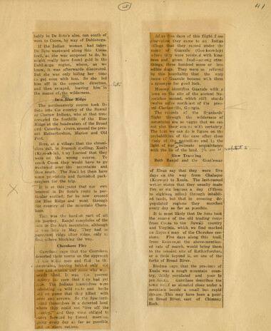
Kephart's address before Bryson City Women's Club
GSMNP_13150_30_03
Kephart's address before Bryson City Women's Club
GSMNP_13150_30_04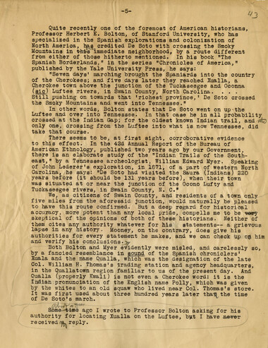
Kephart's address before Bryson City Women's Club
GSMNP_13150_30_05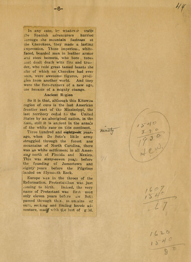
Kephart's address before Bryson City Women's Club
GSMNP_13150_30_06Item’s are ‘child’ level descriptions to ‘parent’ objects, (e.g. one page of a whole book).
-
-
<3) 4/ X bably in De Soto's also, ran south of west to Coosa, by way of Dahlonega. If the Indian woman had taken De Soto westward along this Coosa trail, as she was supposed to do, he might really have found gold in the Dahlonega region, where, as we know, it was afterwards discovered. But she was only biding her time to get even with him. So she led him off in the opposite direction, and then escaped, leaving him in the mazes cf,.the wilderness. Into Blue Ridge The northeasterly course took De Soto into the country of the Suwaii or Cheraw Indians,, who at that time occupied the foothills of the Blue j Ridge at the headwaters cf the Broad and Catawba rivers, around the present Rutherfordton, Marion and Old Fort. Here, at a village that the chroniclers call, in Spanish spelling, Xualn (Ksoo_ah_la), tney learned that they were on the wrong course. To reach Coosa they would have to go westward over tire mountains and then south. The Su_ali let them have some provisions and furnished pack_ carriers for the trip. It is at this point that our own interests in De Soto's route is particular excited; for he now crossed the Blue Ridge and went through the country of the mountain Cherokees. This was the hardest part of all his journey. Ranjel complains of the cold in the high mountains, although it was late in May. They had to ej_.ttrceount ridge, after ridge, only to find others blocking the way. Cherokees Flee Garcilaso_ says that the Cherokees deserted their towns on the appronct _i' the white men and fled to_ th: mo'uniains, leaving behind only old men and women and some who weM nearly blind. It was the poorest eoantry for corn that t ey had yet seen. The Indians tnemsolves were .subsisting en wild ro^ts and herbs .ind on game that they killed with oows and arrows,. So the Spaniard; ound themselves in a deserted land, where they could not "live off the ;cuntry," and they were obliged to aurry forward by forced marches, going every clay as far as possible, and _on short rations. ,.■>"■_■ e days of this flight f.oiri they came to an Indian ,t they record under the Guaxule (Gco_ksoo_lay) where they were received with kindness and given food—among other things, three hundred more or less edible dogs. They were.' so relieved by this hospitality that the very name of Guaxule became wish them 3. synonym for gcod luck. Mooney identifies Guaxule with a ;own on the site of the ancient Na_ eootchee mound, which still stands twelve miles northeast of the present Clarkesville, Georgia. The records of the Spaniards' flight through the wilderness of mountains are so_ vague that we can not plot their course with certainty. The best we can do is figure on the probabilities of the case after close ■tudy of the narratives and i_\ the light of our ^ intimate acquaintance with the lie of the land. , Slow Trave'ing Both Ranjel and the Gent'eman of Elvas say that they were five days en .the way from Ohalaque (Keowee) to Xuala. The last_named writer states that they usually made five or six leagues a day (fifteen to eighteen miles) through inhabited 'lands, but that in crossing depopulated regions they marched every day as far as possible. It is most likely that De Soto took 'the course of the old trading route i from Coosa to the Suwaii country and Virginia, which we find marked on Eoyces map of the Cherokee cessions. Five days along this trail, from Keo\vee,at the above_mentioned rate of march, would bring them to the present site of Ruitherfordton, or a little beyond_ it, on one of the forks of Broad River. . Biedma says that the province of Xuala was a rough mountain country, thinly populated and poor In pro /isiens. Garcilaso describes the town itso.f as situated close under a mountain beside a small but rapid; stream. This may have been a point j on Broad River, east of Chimney | Rock. i ._,_1 *_..' A_
Object’s are ‘parent’ level descriptions to ‘children’ items, (e.g. a book with pages).
-
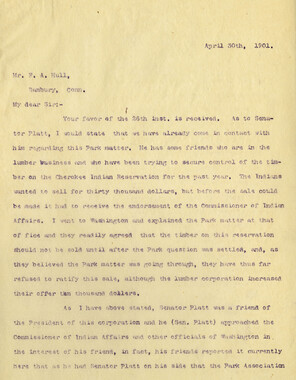
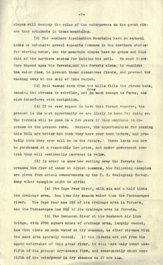
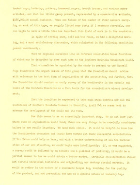
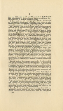
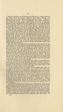
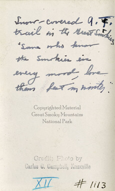
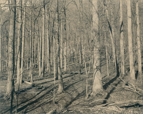
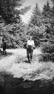
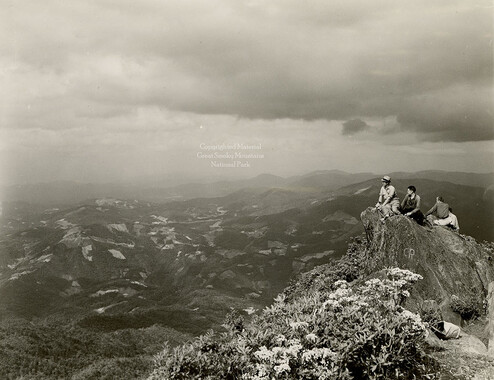
This news clipping describes a speech made by Horace Kephart to the Women’s Club of Bryson City, North Carolina in 1929. The clipping was collected by George Masa. George Masa (1881-1933) was active in the Appalachian Trail Club and in the movement to establish the Great Smoky Mountains National Park. In 1931, he was named to the three-person nomenclature committee for the North Carolina Park Commission and had the responsibility for accurately naming the peaks, streams, and other features. Mutual interests fostered Masa’s friendship with Horace Kephart (1862-1931), a noted author and promoter of the Great Smoky Mountains National Park. Kephart and Masa often hiked together with park officials on inspection trips and provided information to stir public interest. Kephart wrote many articles promoting regional conservation and the park movement.
-
Related items
-
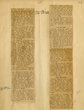
Remarks Made at a Conference of Council of Southern Mountain Workers

-
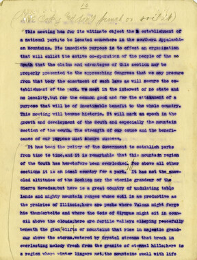
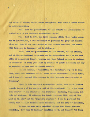
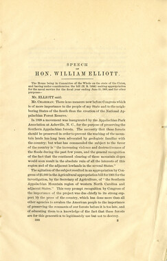
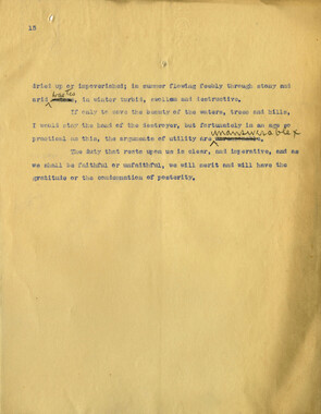
Speech in support of an Appalachian National Park

-
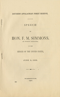
Senate Bill 5228: Senator Simmon's speech
-
Speech in support of an Appalachian National Park

-
Remarks Made at a Conference of Council of Southern Mountain Workers
-
Speech in support of an Appalachian National Park
-
Senate Bill 5228: Senator Simmon's speech
-
Speech in support of an Appalachian National Park
-
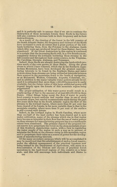
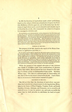
Congressional speech for forest reserve
-
Speech in support of an Appalachian National Park
-
Speech in support of an Appalachian National Park
-
Congressional speech for forest reserve

-
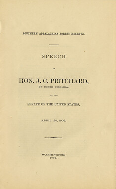
Senator Pritchard's Speech

-
Senate Bill 5228: Senator Simmon's speech
-
Senator Pritchard's Speech
-
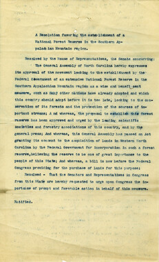
Proposed Appalachian National Forest Reserve
-
Remarks Made at a Conference of Council of Southern Mountain Workers
-
Senate Bill 5228: Senator Simmon's speech
-
Senate Bill 5228: Senator Simmon's speech
-
Senator Pritchard's Speech
-
Congressional speech for forest reserve
-
Senator Pritchard's Speech
-
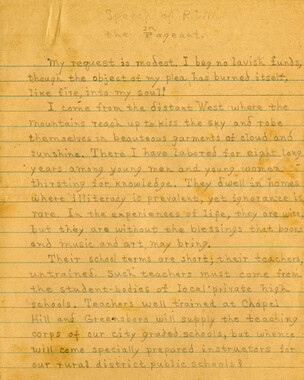
Speech of R. L. M. in the Pageant, page 1
-
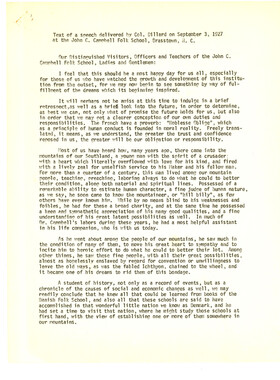
Text of a speech delivered by Col. Dillard on September 3, 1927 at the John C. Campbell Folk School, Brasstown, N.C.
-
Congressional speech for forest reserve
-
Kephart's address before Bryson City Women's Club
-
Speech in support of an Appalachian National Park
-
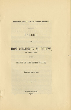
Senate Bill 5228: Senator Depew's speech
-
Congressional speech for forest reserve

-
Senate Bill 5228: Senator Depew's speech
-
Speech in support of an Appalachian National Park
-
Senator Pritchard's Speech
Part of Collection
Great Smoky Mountains - A Park for America
-
Days gone but not forgotten

-
Common forest trees of North Carolina

-
Hardwood Bark, 1924
-
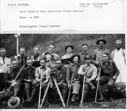
Cataloochee: timber cruisers
-
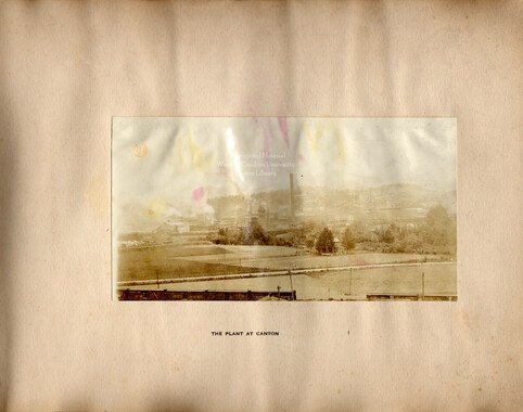
Glimpses of the Plant of the Champion Fibre Co., Canton, North Carolina
-
Mount LeConte

-
Correspondence between Zebulon Weaver, W. E. Bird, A. E. Demaray, George McCoy, J. Ross Eakin, 1934
-
Correspondence regarding 1901 meeting

-
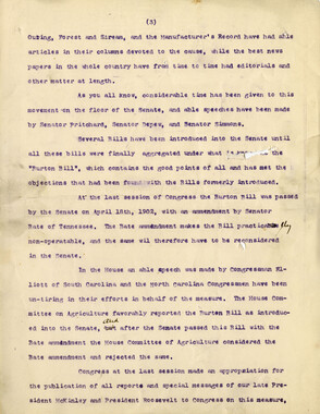
Appalachian National Park Association Newspaper Clippings, 1899-1902
-
Pigeon Forge fields

-
Correspondence regarding the destruction of United States forests

-
Hardwood Bark, 1928

-
Resolution presented to North Carolina
-
Appalachian Trail in winter
-
The Art of Getting Lost

-
Cataloochee tract 214: Eldredge Caldwell – Levi

-
Correspondence between Zebulon Weaver, Fred L. Weede, W. H. Woodbury, David C. Chapman, Mark Squires, Junius G. Adams, March 1932

-
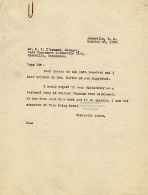
Correspondence between Zebulon Weaver, R. C. D'Armand, and Mrs. Henry H. Horton
-
Winter
-
Scrapbook by A. H. McQuilkin
-
Handbook/ 1931/ Smoky Mountains Hiking Club

-
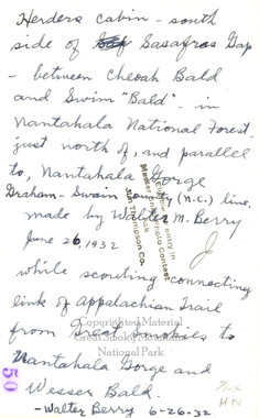
Cabin on Sassafras Gap
-
Appalachian National Park Association Newspaper Clippings, 1899-1902
-
Cataloochee tract 293: E. M. Messer

-
Man with wild turkey

-
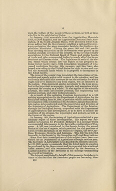
Act making appropriations for the Department of Agriculture

-
Vireo near Parson Bald

-
Ruth Gibson
-
Mount Cammerer
-
Minutes of Meetings of the Appalachian National Park Association
-
Financial receipts and expenditures, 1900
-
Letters supporting Appalachian National Park movement