- Canton Champion Fibre Company (2308)
- Cherokee Traditions (293)
- Civil War in Southern Appalachia (165)
- Craft Revival (1942)
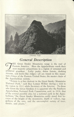
- Great Smoky Mountains - A Park for America (2767)
- Highlights from Western Carolina University (430)
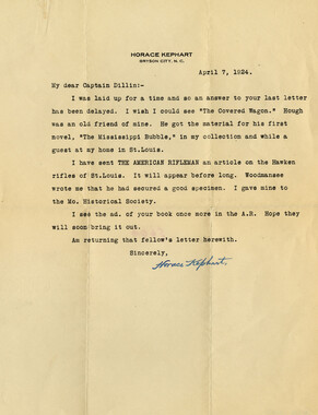
- Horace Kephart (941)
- Journeys Through Jackson (154)
- LGBTQIA+ Archive of Jackson County (24)
- Oral Histories of Western North Carolina (314)
- Picturing Appalachia (6772)
- Stories of Mountain Folk (413)
- Travel Western North Carolina (160)
- Western Carolina University Fine Art Museum Vitreograph Collection (129)
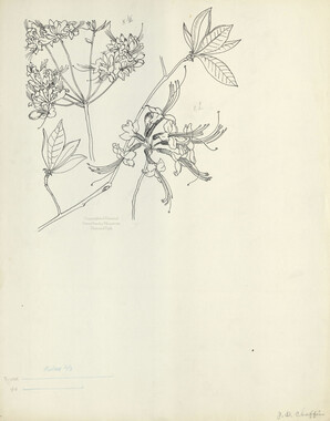
- Western Carolina University Herbarium (92)
- Western Carolina University: Making Memories (708)
- Western Carolina University Publications (2283)
- Western Carolina University Restricted Electronic Theses and Dissertations (146)
- Western North Carolina Regional Maps (71)
- World War II in Southern Appalachia (131)
- Appalachian National Park Association (53)
- Berry, Walter (76)
- Champion Fibre Company (5)
- Fromer, Irving Rhodes, 1913-1994 (70)
- Grant, George Alexander, 1891-1964 (96)
- Kephart, Horace, 1862-1931 (23)
- Masa, George, 1881-1933 (17)
- North Carolina Park Commission (105)
- Roth, Albert, 1890-1974 (142)
- Schenck, Carl Alwin, 1868-1955 (1)
- Stearns, I. K. (2)
- Thompson, James Edward, 1880-1976 (45)
- Weaver, Zebulon, 1872-1948 (55)
- Wilburn, Hiram Coleman, 1880-1967 (72)
- Allanstand Cottage Industries (0)
- Bennett, Kelly, 1890-1974 (0)
- Brasstown Carvers (0)
- Cain, Doreyl Ammons (0)
- Carver, George Washington, 1864?-1943 (0)
- Cathey, Joseph, 1803-1874 (0)
- Champion Paper and Fibre Company (0)
- Cherokee Indian Fair Association (0)
- Cherokee Language Program (0)
- Crittenden, Lorraine (0)
- Crowe, Amanda (0)
- Edmonston, Thomas Benton, 1842-1907 (0)
- Ensley, A. L. (Abraham Lincoln), 1865-1948 (0)
- George Butz (BFS 1907) (0)
- Goodrich, Frances Louisa (0)
- Heard, Marian Gladys (0)
- Kephart, Calvin, 1883-1969 (0)
- Kephart, Laura, 1862-1954 (0)
- Laney, Gideon Thomas, 1889-1976 (0)
- McElhinney, William Julian, 1896-1953 (0)
- Niggli, Josephina, 1910-1983 (0)
- Osborne, Kezia Stradley (0)
- Owens, Samuel Robert, 1918-1995 (0)
- Penland Weavers and Potters (0)
- Rhodes, Judy (0)
- Roberts, Vivienne (0)
- Sherrill's Photography Studio (0)
- Smith, Edward Clark (0)
- Southern Highland Handicraft Guild (0)
- Southern Highlanders, Inc. (0)
- Stalcup, Jesse Bryson (0)
- United States. Indian Arts and Crafts Board (0)
- USFS (0)
- Vance, Zebulon Baird, 1830-1894 (0)
- Western Carolina College (0)
- Western Carolina Teachers College (0)
- Western Carolina University (0)
- Western Carolina University. Mountain Heritage Center (0)
- Whitman, Walt, 1819-1892 (0)
- Williams, Isadora (0)
- 1810s (1)
- 1840s (1)
- 1850s (2)
- 1860s (3)
- 1870s (4)
- 1880s (7)
- 1890s (64)
- 1900s (294)
- 1910s (227)
- 1920s (461)
- 1930s (1585)
- 1940s (82)
- 1950s (15)
- 1960s (13)
- 1970s (47)
- 1980s (14)
- 1990s (17)
- 2000s (31)
- 2010s (1)
- 1600s (0)
- 1700s (0)
- 1800s (0)
- 1820s (0)
- 1830s (0)
- 2020s (0)
- Appalachian Region, Southern (80)
- Asheville (N.C.) (1)
- Avery County (N.C.) (6)
- Blount County (Tenn.) (159)
- Buncombe County (N.C.) (204)
- Cherokee County (N.C.) (10)
- Clay County (N.C.) (3)
- Graham County (N.C.) (108)
- Great Smoky Mountains National Park (N.C. and Tenn.) (416)
- Haywood County (N.C.) (263)
- Henderson County (N.C.) (13)
- Jackson County (N.C.) (58)
- Knox County (Tenn.) (21)
- Knoxville (Tenn.) (11)
- Lake Santeetlah (N.C.) (10)
- Macon County (N.C.) (25)
- Madison County (N.C.) (14)
- McDowell County (N.C.) (5)
- Mitchell County (N.C.) (7)
- Polk County (N.C.) (2)
- Qualla Boundary (22)
- Rutherford County (N.C.) (16)
- Swain County (N.C.) (516)
- Transylvania County (N.C.) (36)
- Watauga County (N.C.) (2)
- Waynesville (N.C.) (2)
- Yancey County (N.C.) (34)
- Aerial Views (3)
- Articles (1)
- Artifacts (object Genre) (4)
- Clippings (information Artifacts) (77)
- Drawings (visual Works) (174)
- Envelopes (2)
- Financial Records (9)
- Fliers (printed Matter) (34)
- Guidebooks (1)
- Interviews (11)
- Land Surveys (102)
- Letters (correspondence) (219)
- Manuscripts (documents) (91)
- Maps (documents) (69)
- Memorandums (14)
- Minutes (administrative Records) (20)
- Negatives (photographs) (282)
- Newsletters (12)
- Paintings (visual Works) (1)
- Pen And Ink Drawings (1)
- Photographs (1657)
- Portraits (39)
- Postcards (15)
- Publications (documents) (107)
- Scrapbooks (3)
- Sound Recordings (7)
- Speeches (documents) (11)
- Transcripts (46)
- Aerial Photographs (0)
- Albums (books) (0)
- Biography (general Genre) (0)
- Cards (information Artifacts) (0)
- Crafts (art Genres) (0)
- Depictions (visual Works) (0)
- Design Drawings (0)
- Facsimiles (reproductions) (0)
- Fiction (general Genre) (0)
- Glass Plate Negatives (0)
- Internegatives (0)
- Newspapers (0)
- Occupation Currency (0)
- Periodicals (0)
- Personal Narratives (0)
- Plans (maps) (0)
- Poetry (0)
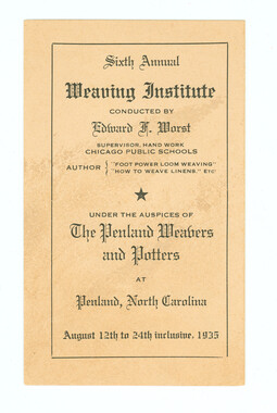
- Programs (documents) (0)
- Questionnaires (0)
- Sheet Music (0)
- Slides (photographs) (0)
- Specimens (0)
- Text Messages (0)
- Tintypes (photographs) (0)
- Video Recordings (physical Artifacts) (0)
- Vitreographs (0)
- Appalachian National Park Association Records (336)
- Carlos C. Campbell Collection (282)
- Cataloochee History Project (65)
- George Masa Collection (89)
- Hiram C. Wilburn Papers (28)
- Historic Photographs Collection (236)
- Horace Kephart Collection (126)
- Humbard Collection (33)
- Jim Thompson Collection (44)
- Love Family Papers (11)
- Map Collection (12)
- R.A. Romanes Collection (10)
- Smoky Mountains Hiking Club Collection (616)
- Zebulon Weaver Collection (107)
- A.L. Ensley Collection (0)
- Appalachian Industrial School Records (0)
- Axley-Meroney Collection (0)
- Bayard Wootten Photograph Collection (0)
- Bethel Rural Community Organization Collection (0)
- Blumer Collection (0)
- C.W. Slagle Collection (0)
- Canton Area Historical Museum (0)
- Cherokee Studies Collection (0)
- Daisy Dame Photograph Album (0)
- Daniel Boone VI Collection (0)
- Doris Ulmann Photograph Collection (0)
- Elizabeth H. Lasley Collection (0)
- Elizabeth Woolworth Szold Fleharty Collection (0)
- Frank Fry Collection (0)
- Gideon Laney Collection (0)
- Hazel Scarborough Collection (0)
- Hunter and Weaver Families Collection (0)
- I. D. Blumenthal Collection (0)
- Isadora Williams Collection (0)
- Jesse Bryson Stalcup Collection (0)
- John B. Battle Collection (0)
- John C. Campbell Folk School Records (0)
- John Parris Collection (0)
- Judaculla Rock project (0)
- Kelly Bennett Collection (0)
- Major Wiley Parris Civil War Letters (0)
- McFee-Misemer Civil War Letters (0)
- Mountain Heritage Center Collection (0)
- Norburn - Robertson - Thomson Families Collection (0)
- Pauline Hood Collection (0)
- Pre-Guild Collection (0)
- Qualla Arts and Crafts Mutual Collection (0)
- Rosser H. Taylor Collection (0)
- Samuel Robert Owens Collection (0)
- Sara Madison Collection (0)
- Sherrill Studio Photo Collection (0)
- Stories of Mountain Folk - Radio Programs (0)
- The Reporter, Western Carolina University (0)
- Venoy and Elizabeth Reed Collection (0)
- WCU Gender and Sexuality Oral History Project (0)
- WCU Mountain Heritage Center Oral Histories (0)
- WCU Oral History Collection - Mountain People, Mountain Lives (0)
- WCU Students Newspapers Collection (0)
- Western North Carolina Tomorrow Black Oral History Project (0)
- William Williams Stringfield Collection (0)
- Appalachian Trail (22)
- Church buildings (9)
- Civilian Conservation Corps (U.S.) (91)
- Dams (21)
- Floods (1)
- Forest conservation (11)
- Forests and forestry (42)
- Great Smoky Mountains National Park (N.C. and Tenn.) (64)
- Hunting (2)
- Logging (25)
- Maps (74)
- North Carolina -- Maps (5)
- Postcards (15)
- Railroad trains (8)
- Sports (4)
- Storytelling (2)
- Waterfalls -- Great Smoky Mountains (N.C. and Tenn.) (39)
- African Americans (0)
- Artisans (0)
- Cherokee art (0)
- Cherokee artists -- North Carolina (0)
- Cherokee language (0)
- Cherokee pottery (0)
- Cherokee women (0)
- College student newspapers and periodicals (0)
- Dance (0)
- Education (0)
- Folk music (0)
- Forced removal, 1813-1903 (0)
- Gender nonconformity (0)
- Landscape photography (0)
- Mines and mineral resources (0)
- Paper industry (0)
- Pottery (0)
- Rural electrification -- North Carolina, Western (0)
- School integration -- Southern States (0)
- Segregation -- North Carolina, Western (0)
- Slavery (0)
- Weaving -- Appalachian Region, Southern (0)
- Wood-carving -- Appalachian Region, Southern (0)
- World War, 1939-1945 (0)
- Sound (7)
- StillImage (2172)
- Text (655)
- MovingImage (0)
Guyot's geographic notes on the southern Appalachians
Guyot's geographic notes on the southern Appalachians
GSMNP_13150_25_1067_01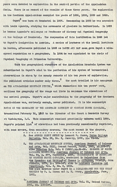
Guyot's geographic notes on the southern Appalachians
GSMNP_13150_25_1067_02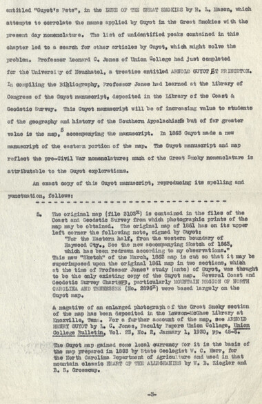
Guyot's geographic notes on the southern Appalachians
GSMNP_13150_25_1067_03
Guyot's geographic notes on the southern Appalachians
GSMNP_13150_25_1067_04
Guyot's geographic notes on the southern Appalachians
GSMNP_13150_25_1067_05
Guyot's geographic notes on the southern Appalachians
GSMNP_13150_25_1067_06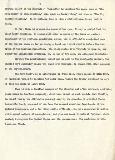
Guyot's geographic notes on the southern Appalachians
GSMNP_13150_25_1067_07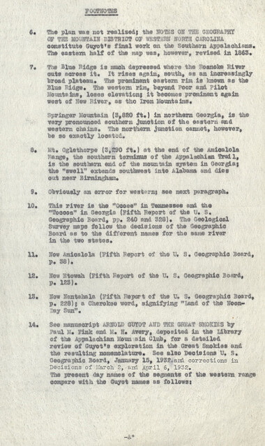
Guyot's geographic notes on the southern Appalachians
GSMNP_13150_25_1067_08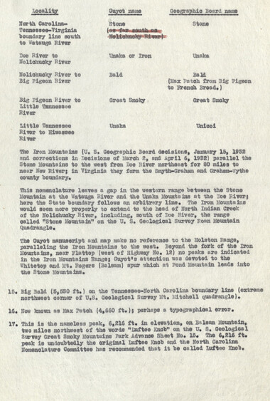
Guyot's geographic notes on the southern Appalachians
GSMNP_13150_25_1067_09
Guyot's geographic notes on the southern Appalachians
GSMNP_13150_25_1067_10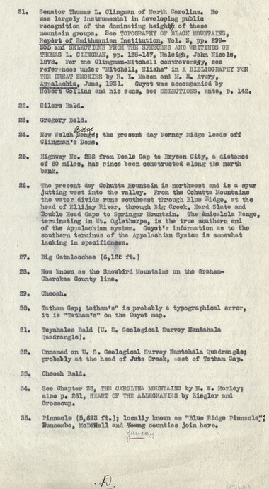
Guyot's geographic notes on the southern Appalachians
GSMNP_13150_25_1067_11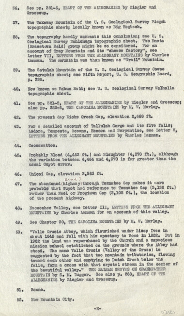
Guyot's geographic notes on the southern Appalachians
GSMNP_13150_25_1067_12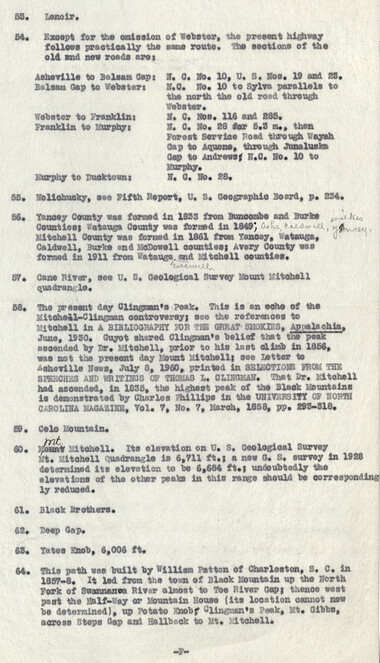
Guyot's geographic notes on the southern Appalachians
GSMNP_13150_25_1067_13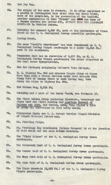
Guyot's geographic notes on the southern Appalachians
GSMNP_13150_25_1067_14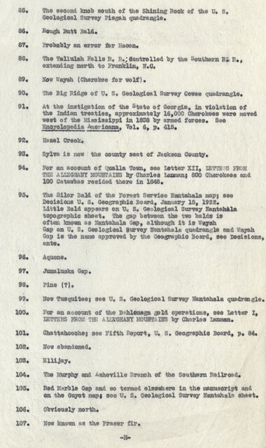
Guyot's geographic notes on the southern Appalachians
GSMNP_13150_25_1067_15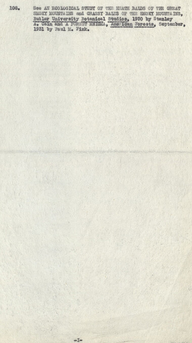
Guyot's geographic notes on the southern Appalachians
GSMNP_13150_25_1067_16Item’s are ‘child’ level descriptions to ‘parent’ objects, (e.g. one page of a whole book).
-
-
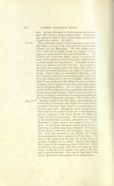
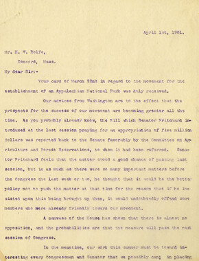
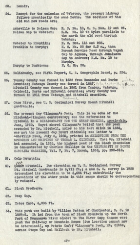
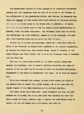
53. Lenoir, 54. Except for the omission of Webster, the present highway follows practically the same route. The sections of the old end new roads are? Asheville to Balsam Gap? N. 0. No. 10, U. S. Nos. 19 and 28. Balsam Gap to Webster? N.O. No. 10 to Sylva parallels to the north the old road through Vebster. Webster to Franklin? N. C. Nos. 116 and 285. Franklin to Murphy? N. C. No. 28 for 5.3 m., then Forest Service Road through Wayah Gap to Aquene, through Junaluska Gap to Andrews* H.C. No. 10 to Murphy. Murphy to Duoktown? N. C. No. 28. 55. Nolichucky, see Fifth Report, U. S. Geographic Board, p. 234* 56. Yancey County was formed in 1833 from Buncombe and Burks p,It ht* Counties} Watauga County was fortsid in 1849; ft Mitchell County was formed in 1861 from Yanaey, Watauga, 0 Caldwell, Burke and McDowell counties} Avery County was formed in 1911 from Watauga, and Mitchell oounties. 57. Cane River, see U. •« Geological Survey Mount Mitchell ouadranr-le. 58. The present day Clingmsn's Peak. This is an echo of the Mitchell-Clingman controversy} see ths references to Mitchell in A BIBLIOGRAPHY IUR TIE GREAT SMOKIES, Appalachia. June, 1930, Guyot shmred Clingman's belief that the peak ascended by Dr. Mitchell, prior to his last climb in 1856, was not the present day Mount Mitchell) see Letter to Asheville News, July 8, 1960, printed in SELECTIONS FROM TBS SPEECHES AND WRITINGS OF THOMAS L. CLINGMAN. That Dr. Mitchell had ascended, in 1833, the highest peak of the Black Mountains is demonstrated by Charles Phillips in the UNIVERSITY OF NORTH CAROLINA MAGAZINE, Vol. 7, No. 7, March, 1858, pp. 293-818. 59. Colo fountain. 60. 2$*tt* Mtehell. Its elevation on U. s. Geological Survey Mt. Mitchell (^uadrangla is 6,711 ft.j a new G. S. survey in 1928 determined its elevation to be 6,684 ft.} undoubtedly the elevations of the other peaks In this rangs should be corresponding ly reduced. 61. Block Brothers. 62. Deep Gap. 68. Yates Snob, 6,006 ft. 64. This path was built by William Pat ton of Charleston, S. C. in 1857-8. It led from the town of Bleak Mountain up the North Fork of Swannanwa River almost to Toe River Gap} thenoe west past the Half-Say or Mountain House (its location cannot now be determined), up Potato Knobf Oiingnaoi** Peak, Mt. Oibbs, across Steps Gap and Hallbaok to Mt. itchell. —1 -
Object’s are ‘parent’ level descriptions to ‘children’ items, (e.g. a book with pages).
-
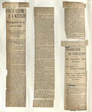
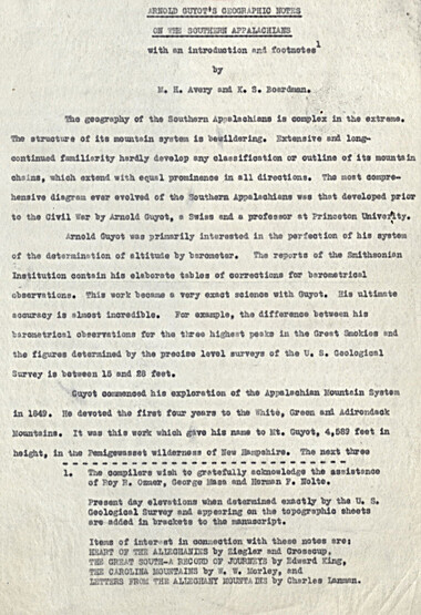
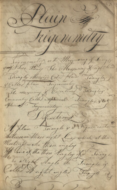
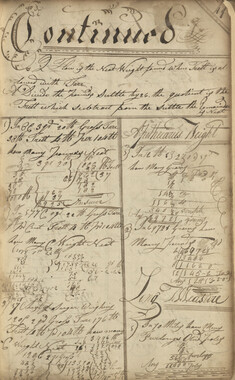
This 16-page manuscript recounts the involvement of Arnold Guyot in the Great Smoky Mountains. A geologist and geographer, Arnold Henry Guyot (1807-1884), began his exploration of the Appalachians in 1849. His purpose was to record the elevations of various peaks and develop a systematic geographic outline of the mountain systems of the eastern United States. The manuscript was collected by George Masa. Born Masahara Iizuka and raised in Japan, George Masa (1881-1933) emigrated to the U.S. when he was 20 years old and, in 1915, came to Asheville, where he lived the rest of his life. Masa was active in the Appalachian Trail Club and in the movement to establish the Great Smoky Mountains National Park. Myron Haliburton Avery (1899–1952), who was president of the Potomac Appalachian Trail Club and chairman of the board of the Appalachian Trail Conference.
-


Part of Collection
Great Smoky Mountains - A Park for America