- Canton Champion Fibre Company (2308)
- Cherokee Traditions (293)
- Civil War in Southern Appalachia (165)
- Craft Revival (1942)
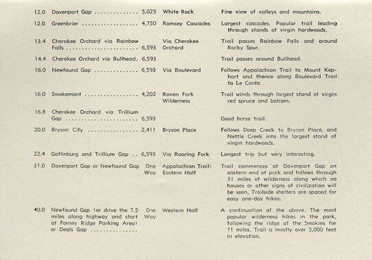
- Great Smoky Mountains - A Park for America (2767)
- Highlights from Western Carolina University (430)
- Horace Kephart (941)
- Journeys Through Jackson (154)
- LGBTQIA+ Archive of Jackson County (26)
- Oral Histories of Western North Carolina (314)
- Picturing Appalachia (6772)
- Stories of Mountain Folk (413)
- Travel Western North Carolina (160)
- Western Carolina University Fine Art Museum Vitreograph Collection (129)
- Western Carolina University Herbarium (92)
- Western Carolina University: Making Memories (708)
- Western Carolina University Publications (2283)
- Western Carolina University Restricted Electronic Theses and Dissertations (146)
- Western North Carolina Regional Maps (71)
- World War II in Southern Appalachia (131)
- Appalachian National Park Association (53)
- Berry, Walter (76)
- Champion Fibre Company (5)
- Fromer, Irving Rhodes, 1913-1994 (70)
- Grant, George Alexander, 1891-1964 (96)
- Kephart, Horace, 1862-1931 (23)
- Masa, George, 1881-1933 (17)
- North Carolina Park Commission (105)
- Roth, Albert, 1890-1974 (142)
- Schenck, Carl Alwin, 1868-1955 (1)
- Stearns, I. K. (2)
- Thompson, James Edward, 1880-1976 (45)
- Weaver, Zebulon, 1872-1948 (55)
- Wilburn, Hiram Coleman, 1880-1967 (72)
- Allanstand Cottage Industries (0)
- Bennett, Kelly, 1890-1974 (0)
- Brasstown Carvers (0)
- Cain, Doreyl Ammons (0)
- Carver, George Washington, 1864?-1943 (0)
- Cathey, Joseph, 1803-1874 (0)
- Champion Paper and Fibre Company (0)
- Cherokee Indian Fair Association (0)
- Cherokee Language Program (0)
- Crittenden, Lorraine (0)
- Crowe, Amanda (0)
- Edmonston, Thomas Benton, 1842-1907 (0)
- Ensley, A. L. (Abraham Lincoln), 1865-1948 (0)
- George Butz (BFS 1907) (0)
- Goodrich, Frances Louisa (0)
- Heard, Marian Gladys (0)
- Kephart, Calvin, 1883-1969 (0)
- Kephart, Laura, 1862-1954 (0)
- Laney, Gideon Thomas, 1889-1976 (0)
- McElhinney, William Julian, 1896-1953 (0)
- Niggli, Josephina, 1910-1983 (0)
- Osborne, Kezia Stradley (0)
- Owens, Samuel Robert, 1918-1995 (0)
- Penland Weavers and Potters (0)
- Rhodes, Judy (0)
- Roberts, Vivienne (0)
- Sherrill's Photography Studio (0)
- Smith, Edward Clark (0)
- Southern Highland Handicraft Guild (0)
- Southern Highlanders, Inc. (0)
- Stalcup, Jesse Bryson (0)
- United States. Indian Arts and Crafts Board (0)
- USFS (0)
- Vance, Zebulon Baird, 1830-1894 (0)
- Western Carolina College (0)
- Western Carolina Teachers College (0)
- Western Carolina University (0)
- Western Carolina University. Mountain Heritage Center (0)
- Whitman, Walt, 1819-1892 (0)
- Williams, Isadora (0)
- 1810s (1)
- 1840s (1)
- 1850s (2)
- 1860s (3)
- 1870s (4)
- 1880s (7)
- 1890s (64)
- 1900s (294)
- 1910s (227)
- 1920s (461)
- 1930s (1585)
- 1940s (82)
- 1950s (15)
- 1960s (13)
- 1970s (47)
- 1980s (14)
- 1990s (17)
- 2000s (31)
- 2010s (1)
- 1600s (0)
- 1700s (0)
- 1800s (0)
- 1820s (0)
- 1830s (0)
- 2020s (0)
- Appalachian Region, Southern (80)
- Asheville (N.C.) (1)
- Avery County (N.C.) (6)
- Blount County (Tenn.) (159)
- Buncombe County (N.C.) (204)
- Cherokee County (N.C.) (10)
- Clay County (N.C.) (3)
- Graham County (N.C.) (108)
- Great Smoky Mountains National Park (N.C. and Tenn.) (438)
- Haywood County (N.C.) (263)
- Henderson County (N.C.) (13)
- Jackson County (N.C.) (58)
- Knox County (Tenn.) (21)
- Knoxville (Tenn.) (11)
- Lake Santeetlah (N.C.) (10)
- Macon County (N.C.) (25)
- Madison County (N.C.) (14)
- McDowell County (N.C.) (5)
- Mitchell County (N.C.) (7)
- Polk County (N.C.) (2)
- Qualla Boundary (22)
- Rutherford County (N.C.) (16)
- Swain County (N.C.) (516)
- Transylvania County (N.C.) (36)
- Watauga County (N.C.) (2)
- Waynesville (N.C.) (2)
- Yancey County (N.C.) (34)
- Aerial Views (3)
- Articles (1)
- Artifacts (object Genre) (4)
- Bibliographies (1)
- Clippings (information Artifacts) (77)
- Drawings (visual Works) (174)
- Envelopes (2)
- Financial Records (9)
- Fliers (printed Matter) (34)
- Guidebooks (1)
- Interviews (12)
- Land Surveys (102)
- Letters (correspondence) (219)
- Manuscripts (documents) (91)
- Maps (documents) (86)
- Memorandums (14)
- Minutes (administrative Records) (20)
- Negatives (photographs) (282)
- Newsletters (12)
- Paintings (visual Works) (1)
- Pen And Ink Drawings (1)
- Photographs (1657)
- Portraits (40)
- Postcards (15)
- Publications (documents) (107)
- Scrapbooks (3)
- Sheet Music (1)
- Songs (musical Compositions) (2)
- Sound Recordings (7)
- Speeches (documents) (11)
- Transcripts (46)
- Aerial Photographs (0)
- Albums (books) (0)
- Biography (general Genre) (0)
- Cards (information Artifacts) (0)
- Crafts (art Genres) (0)
- Depictions (visual Works) (0)
- Design Drawings (0)
- Facsimiles (reproductions) (0)
- Fiction (general Genre) (0)
- Glass Plate Negatives (0)
- Internegatives (0)
- Newspapers (0)
- Occupation Currency (0)
- Periodicals (0)
- Personal Narratives (0)
- Plans (maps) (0)
- Poetry (0)
- Programs (documents) (0)
- Questionnaires (0)
- Slides (photographs) (0)
- Specimens (0)
- Text Messages (0)
- Tintypes (photographs) (0)
- Video Recordings (physical Artifacts) (0)
- Vitreographs (0)
- Appalachian National Park Association Records (336)
- Carlos C. Campbell Collection (282)
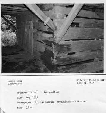
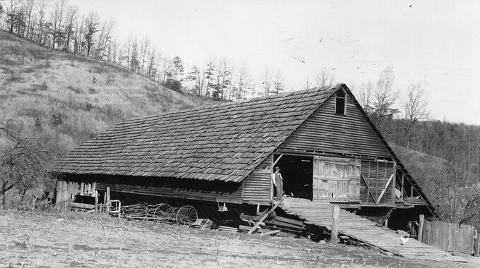
- Cataloochee History Project (65)
- George Masa Collection (89)
- Hiram C. Wilburn Papers (28)
- Historic Photographs Collection (236)
- Horace Kephart Collection (126)
- Humbard Collection (33)
- Jim Thompson Collection (44)
- Love Family Papers (11)
- Map Collection (12)
- R.A. Romanes Collection (10)
- Smoky Mountains Hiking Club Collection (616)
- Zebulon Weaver Collection (107)
- A.L. Ensley Collection (0)
- Appalachian Industrial School Records (0)
- Axley-Meroney Collection (0)
- Bayard Wootten Photograph Collection (0)
- Bethel Rural Community Organization Collection (0)
- Blumer Collection (0)
- C.W. Slagle Collection (0)
- Canton Area Historical Museum (0)
- Cherokee Studies Collection (0)
- Daisy Dame Photograph Album (0)
- Daniel Boone VI Collection (0)
- Doris Ulmann Photograph Collection (0)
- Elizabeth H. Lasley Collection (0)
- Elizabeth Woolworth Szold Fleharty Collection (0)
- Frank Fry Collection (0)
- Gideon Laney Collection (0)
- Hazel Scarborough Collection (0)
- Hunter and Weaver Families Collection (0)
- I. D. Blumenthal Collection (0)
- Isadora Williams Collection (0)
- Jesse Bryson Stalcup Collection (0)
- John B. Battle Collection (0)
- John C. Campbell Folk School Records (0)
- John Parris Collection (0)
- Judaculla Rock project (0)
- Kelly Bennett Collection (0)
- Major Wiley Parris Civil War Letters (0)
- McFee-Misemer Civil War Letters (0)
- Mountain Heritage Center Collection (0)
- Norburn - Robertson - Thomson Families Collection (0)
- Pauline Hood Collection (0)
- Pre-Guild Collection (0)
- Qualla Arts and Crafts Mutual Collection (0)
- Rosser H. Taylor Collection (0)
- Samuel Robert Owens Collection (0)
- Sara Madison Collection (0)
- Sherrill Studio Photo Collection (0)
- Stories of Mountain Folk - Radio Programs (0)
- The Reporter, Western Carolina University (0)
- Venoy and Elizabeth Reed Collection (0)
- WCU Gender and Sexuality Oral History Project (0)
- WCU Mountain Heritage Center Oral Histories (0)
- WCU Oral History Collection - Mountain People, Mountain Lives (0)
- WCU Students Newspapers Collection (0)
- Western North Carolina Tomorrow Black Oral History Project (0)
- William Williams Stringfield Collection (0)
- Appalachian Trail (22)
- Church buildings (9)
- Civilian Conservation Corps (U.S.) (91)
- Dams (21)
- Floods (1)
- Forest conservation (11)
- Forests and forestry (42)
- Great Smoky Mountains National Park (N.C. and Tenn.) (82)
- Hunting (2)
- Logging (25)
- Maps (74)
- North Carolina -- Maps (5)
- Postcards (15)
- Railroad trains (8)
- Sports (4)
- Storytelling (2)
- Waterfalls -- Great Smoky Mountains (N.C. and Tenn.) (39)
- African Americans (0)
- Artisans (0)
- Cherokee art (0)
- Cherokee artists -- North Carolina (0)
- Cherokee language (0)
- Cherokee pottery (0)
- Cherokee women (0)
- College student newspapers and periodicals (0)
- Dance (0)
- Education (0)
- Folk music (0)
- Forced removal, 1813-1903 (0)
- Gender nonconformity (0)
- Landscape photography (0)
- Mines and mineral resources (0)
- Paper industry (0)
- Pottery (0)
- Rural electrification -- North Carolina, Western (0)
- School integration -- Southern States (0)
- Segregation -- North Carolina, Western (0)
- Slavery (0)
- Weaving -- Appalachian Region, Southern (0)
- Wood-carving -- Appalachian Region, Southern (0)
- World War, 1939-1945 (0)
- Sound (7)
- StillImage (2172)
- Text (655)
- MovingImage (0)
Federal court records: Stevenson et al. v. Fain et al.: Telico River area

Federal court records: Stevenson et al. v. Fain et al.: Telico River area
GSMNP_13150_16_1133_01
Federal court records: Stevenson et al. v. Fain et al.: Telico River area
GSMNP_13150_16_1133_02
Federal court records: Stevenson et al. v. Fain et al.: Telico River area
GSMNP_13150_16_1133_03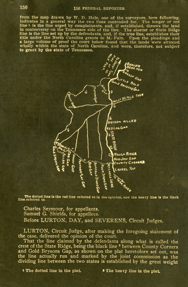
Federal court records: Stevenson et al. v. Fain et al.: Telico River area
GSMNP_13150_16_1133_04
Federal court records: Stevenson et al. v. Fain et al.: Telico River area
GSMNP_13150_16_1133_05
Federal court records: Stevenson et al. v. Fain et al.: Telico River area
GSMNP_13150_16_1133_06
Federal court records: Stevenson et al. v. Fain et al.: Telico River area
GSMNP_13150_16_1133_07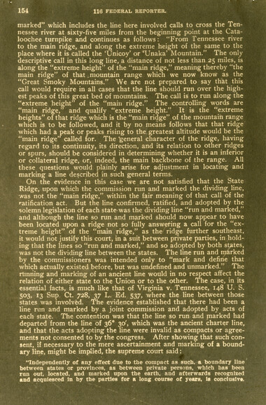
Federal court records: Stevenson et al. v. Fain et al.: Telico River area
GSMNP_13150_16_1133_08
Federal court records: Stevenson et al. v. Fain et al.: Telico River area
GSMNP_13150_16_1133_09
Federal court records: Stevenson et al. v. Fain et al.: Telico River area
GSMNP_13150_16_1133_10Item’s are ‘child’ level descriptions to ‘parent’ objects, (e.g. one page of a whole book).
-
-
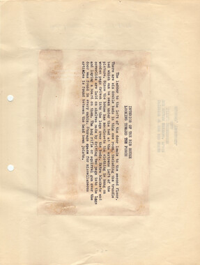
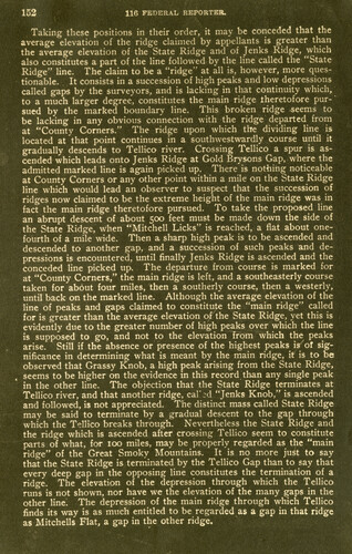
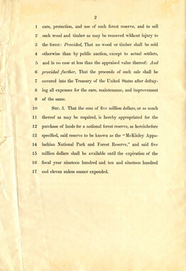
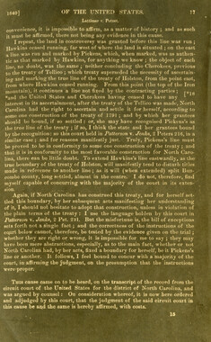
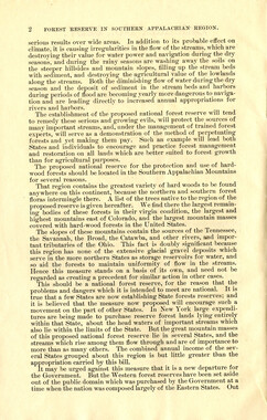
102 116 FEDERAL REPORTER. Taking these positions in their order, it may be conceded that the average elevation of the ridge claimed by appellants is greater than the average elevation of the State Ridge and of Jenks Ridge, which also constitutes a part of the line followed by the line called the "State Ridge" line. The claim to be a "ridge" at all is, however, more questionable. It consists in a succession of high peaks and low depressions called gaps by the surveyors, and is lacking in that continuity which, to a much larger degree, constitutes the main ridge theretofore pur-' sued by the marked boundary line. This broken ridge seems to be lacking in any obvious connection with the ridge departed from at "County Corners." The ridge upon which the dividing line is located at that point continues in a southwestwardly course until it gradually descends to Tellico river. Crossing Tellico a spur is ascended which leads onto Jenks Ridge at Gold Brysons Gap, where the admitted marked line is again picked up. There is nothing noticeable at County Corners or any other point within a mile on the State Ridge line which would lead an observer to suspect that the succession of ridges now claimed to be the extreme height of the main ridge was in fact the main ridge theretofore pursued. To take the proposed line an abrupt descent of about 500 feet must be made down the side of the State Ridge, when "Mitchell Licks" is reached, a flat about one- fourth of a mile wide. Then a sharp high peak is to be ascended and descended to another gap, and a succession of such peaks and depressions is encountered, until finally Jenks Ridge is ascended and the conceded line picked up. The departure from course is marked for at "County Corners," the main ridge is left, and a southeasterly course taken for about four miles, then a southerly course, then a westerly, until back on the marked line. Although the average elevation of the line of peaks and gaps claimed to constitute the "main ridge" called for is greater than the average elevation of the State Ridge, yet this is evidently due to the greater number of high peaks over which the line is supposed to go, and not to the elevation from which the peaks arise. Still if the absence or presence of the highest peaks is of significance in determining what is meant by the main ridge, it is to be observed that Grassy Knob, a high peak arising from the State Ridge, seems to be higher on the evidence in this record than any single peak in the other line. The objection that the State Ridge terminates at Tellico river, and that another ridge, calAd "Jenks Knob," is ascended and followed, is not appreciated. The distinct mass called State Ridge may be said to terminate by a gradual descent to the gap through which the T°llico breaks through. Nevertheless the State Ridge and the ridge which is ascended after crossing Tellico seem to constitute parts of what, for 100 miles, may be properly regarded as the "main ridge" of the Great Smoky Mountains. It is no more just to say that the State Ridge is terminated by the Tellico Gap than to say that every deep gap in the opposing line constitutes the termination of a ridge. The elevation of the depression through which the Tellico runs is not shown, nor have we the elevation of the many gaps in the other line. The depression of the main ridge through which Tellico finds its way is as much entitled to be regarded as a gap in that ridge as Mitchells Flat, a gap in the other ridge.
Object’s are ‘parent’ level descriptions to ‘children’ items, (e.g. a book with pages).
-
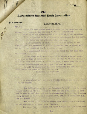
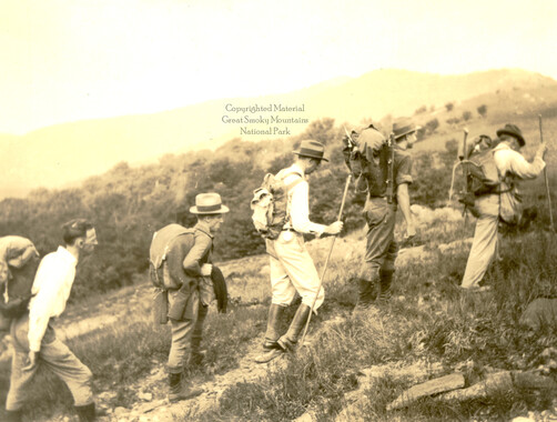
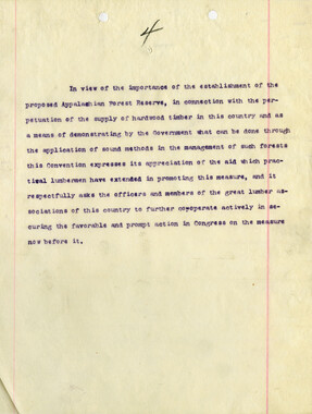
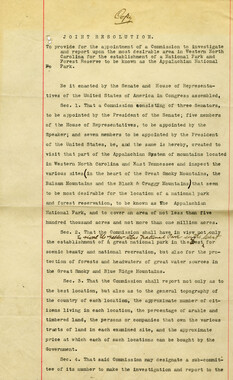
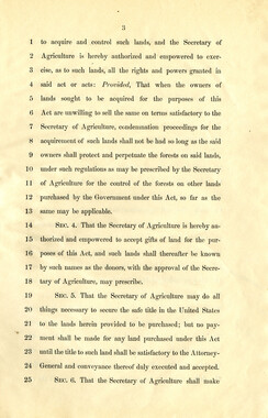
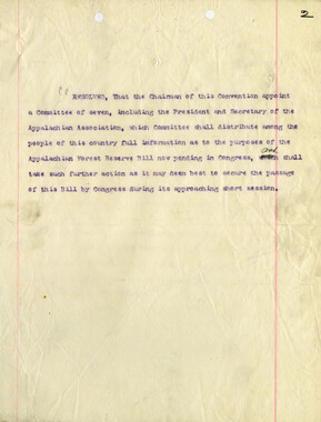
These copies of federal court records were collected by photographer, George Masa. Born Masahara Iizuka and raised in Japan, photographer George Masa (1881-1933) was active in the Appalachian Trail Club and in the movement to establish the Great Smoky Mountains National Park. In 1931, Masa was named to the three-person nomenclature committee for the North Carolina Park Commission and had the responsibility for accurately naming the peaks, streams, and other features. No doubt, these records pertain to the Smokies region and the disposition of land that would eventually become the Great Smoky Mountains National Park.
-


Part of Collection
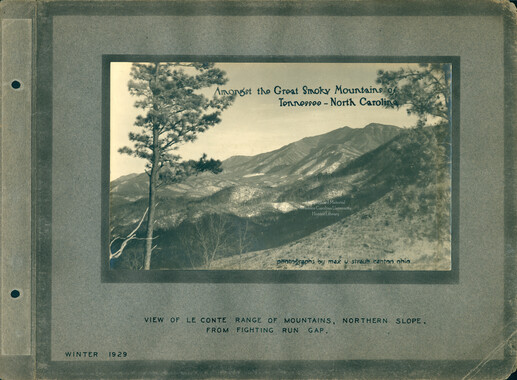
Great Smoky Mountains - A Park for America