Western Carolina University (21)
View all
- Canton Champion Fibre Company (2308)
- Cherokee Traditions (291)
- Civil War in Southern Appalachia (165)
- Craft Revival (1942)
- George Masa Collection (137)
- Great Smoky Mountains - A Park for America (2900)
- Highlights from Western Carolina University (422)
- Horace Kephart (973)
- Journeys Through Jackson (159)
- LGBTQIA+ Archive of Jackson County (85)
- Oral Histories of Western North Carolina (316)
- Picturing Appalachia (6797)
- Stories of Mountain Folk (413)
- Travel Western North Carolina (153)
- Western Carolina University Fine Art Museum Vitreograph Collection (129)
- Western Carolina University Herbarium (92)
- Western Carolina University: Making Memories (738)
- Western Carolina University Publications (2491)
- Western Carolina University Restricted Electronic Theses and Dissertations (146)
- Western North Carolina Regional Maps (71)
- World War II in Southern Appalachia (131)
University of North Carolina Asheville (6)
View all
- Allanstand Cottage Industries (62)
- Appalachian National Park Association (53)
- Bennett, Kelly, 1890-1974 (1463)
- Berry, Walter (76)
- Brasstown Carvers (40)
- Carver, George Washington, 1864?-1943 (26)
- Cathey, Joseph, 1803-1874 (1)
- Champion Fibre Company (233)
- Champion Paper and Fibre Company (297)
- Cherokee Indian Fair Association (16)
- Cherokee Language Program (22)
- Crowe, Amanda (40)
- Edmonston, Thomas Benton, 1842-1907 (7)
- Ensley, A. L. (Abraham Lincoln), 1865-1948 (275)
- Fromer, Irving Rhodes, 1913-1994 (70)
- George Butz (BFS 1907) (46)
- Goodrich, Frances Louisa (120)
- Grant, George Alexander, 1891-1964 (96)
- Heard, Marian Gladys (60)
- Kephart, Calvin, 1883-1969 (15)
- Kephart, Horace, 1862-1931 (313)
- Kephart, Laura, 1862-1954 (67)
- Laney, Gideon Thomas, 1889-1976 (439)
- Masa, George, 1881-1933 (61)
- McElhinney, William Julian, 1896-1953 (44)
- Niggli, Josephina, 1910-1983 (10)
- North Carolina Park Commission (105)
- Osborne, Kezia Stradley (9)
- Owens, Samuel Robert, 1918-1995 (11)
- Penland Weavers and Potters (36)
- Roberts, Vivienne (15)
- Roth, Albert, 1890-1974 (142)
- Schenck, Carl Alwin, 1868-1955 (1)
- Sherrill's Photography Studio (2565)
- Southern Highland Handicraft Guild (127)
- Southern Highlanders, Inc. (71)
- Stalcup, Jesse Bryson (46)
- Stearns, I. K. (213)
- Thompson, James Edward, 1880-1976 (226)
- United States. Indian Arts and Crafts Board (130)
- USFS (683)
- Vance, Zebulon Baird, 1830-1894 (1)
- Weaver, Zebulon, 1872-1948 (58)
- Western Carolina College (230)
- Western Carolina Teachers College (282)
- Western Carolina University (2008)
- Western Carolina University. Mountain Heritage Center (18)
- Whitman, Walt, 1819-1892 (10)
- Wilburn, Hiram Coleman, 1880-1967 (73)
- Williams, Isadora (3)
- Cain, Doreyl Ammons (0)
- Crittenden, Lorraine (0)
- Rhodes, Judy (0)
- Smith, Edward Clark (0)
- Appalachian Region, Southern (2940)
- Asheville (N.C.) (1944)
- Avery County (N.C.) (26)
- Blount County (Tenn.) (195)
- Buncombe County (N.C.) (1680)
- Cherokee County (N.C.) (283)
- Clay County (N.C.) (556)
- Graham County (N.C.) (238)
- Great Smoky Mountains National Park (N.C. and Tenn.) (525)
- Haywood County (N.C.) (3573)
- Henderson County (N.C.) (70)
- Jackson County (N.C.) (4919)
- Knox County (Tenn.) (35)
- Knoxville (Tenn.) (13)
- Lake Santeetlah (N.C.) (10)
- Macon County (N.C.) (421)
- Madison County (N.C.) (216)
- McDowell County (N.C.) (39)
- Mitchell County (N.C.) (135)
- Polk County (N.C.) (35)
- Qualla Boundary (982)
- Rutherford County (N.C.) (78)
- Swain County (N.C.) (2185)
- Transylvania County (N.C.) (270)
- Watauga County (N.C.) (12)
- Waynesville (N.C.) (86)
- Yancey County (N.C.) (72)
- Aerial Photographs (3)
- Aerial Views (60)
- Albums (books) (4)
- Articles (1)
- Artifacts (object Genre) (228)
- Bibliographies (1)
- Biography (general Genre) (2)
- Cards (information Artifacts) (38)
- Clippings (information Artifacts) (192)
- Copybooks (instructional Materials) (3)
- Crafts (art Genres) (622)
- Depictions (visual Works) (21)
- Design Drawings (1)
- Digital Moving Image Formats (2)
- Drawings (visual Works) (185)
- Envelopes (101)
- Exhibitions (events) (1)
- Facsimiles (reproductions) (1)
- Fiction (general Genre) (4)
- Financial Records (12)
- Fliers (printed Matter) (67)
- Glass Plate Negatives (381)
- Guidebooks (2)
- Internegatives (10)
- Interviews (817)
- Land Surveys (102)
- Letters (correspondence) (1045)
- Manuscripts (documents) (618)
- Maps (documents) (177)
- Memorandums (25)
- Minutes (administrative Records) (59)
- Negatives (photographs) (6090)
- Newsletters (1290)
- Newspapers (2)
- Notebooks (8)
- Occupation Currency (1)
- Paintings (visual Works) (1)
- Pen And Ink Drawings (1)
- Periodicals (193)
- Personal Narratives (10)
- Photographs (12976)
- Plans (maps) (1)
- Poetry (6)
- Portraits (4568)
- Postcards (329)
- Programs (documents) (181)
- Publications (documents) (2444)
- Questionnaires (65)
- Relief Prints (26)
- Sayings (literary Genre) (1)
- Scrapbooks (282)
- Sheet Music (2)
- Slides (photographs) (402)
- Songs (musical Compositions) (2)
- Sound Recordings (796)
- Specimens (92)
- Speeches (documents) (18)
- Tintypes (photographs) (8)
- Transcripts (324)
- Text Messages (0)
- A.L. Ensley Collection (275)
- Appalachian Industrial School Records (7)
- Appalachian National Park Association Records (336)
- Axley-Meroney Collection (2)
- Bayard Wootten Photograph Collection (20)
- Bethel Rural Community Organization Collection (7)
- Blumer Collection (5)
- C.W. Slagle Collection (20)
- Canton Area Historical Museum (2110)
- Carlos C. Campbell Collection (462)
- Cataloochee History Project (64)
- Cherokee Studies Collection (4)
- Daisy Dame Photograph Album (5)
- Daniel Boone VI Collection (1)
- Doris Ulmann Photograph Collection (112)
- Elizabeth H. Lasley Collection (1)
- Elizabeth Woolworth Szold Fleharty Collection (4)
- Frank Fry Collection (95)
- George Masa Collection (173)
- Gideon Laney Collection (452)
- Hazel Scarborough Collection (2)
- Hiram C. Wilburn Papers (28)
- Historic Photographs Collection (236)
- Horace Kephart Collection (861)
- Humbard Collection (33)
- Hunter and Weaver Families Collection (1)
- I. D. Blumenthal Collection (4)
- Isadora Williams Collection (4)
- Jesse Bryson Stalcup Collection (47)
- Jim Thompson Collection (224)
- John B. Battle Collection (7)
- John C. Campbell Folk School Records (80)
- John Parris Collection (6)
- Judaculla Rock project (2)
- Kelly Bennett Collection (1482)
- Love Family Papers (11)
- Major Wiley Parris Civil War Letters (3)
- Map Collection (12)
- McFee-Misemer Civil War Letters (34)
- Mountain Heritage Center Collection (4)
- Norburn - Robertson - Thomson Families Collection (44)
- Pauline Hood Collection (7)
- Pre-Guild Collection (2)
- Qualla Arts and Crafts Mutual Collection (12)
- R.A. Romanes Collection (681)
- Rosser H. Taylor Collection (1)
- Samuel Robert Owens Collection (94)
- Sara Madison Collection (144)
- Sherrill Studio Photo Collection (2558)
- Smoky Mountains Hiking Club Collection (616)
- Stories of Mountain Folk - Radio Programs (374)
- The Reporter, Western Carolina University (510)
- Venoy and Elizabeth Reed Collection (16)
- WCU Gender and Sexuality Oral History Project (32)
- WCU Mountain Heritage Center Oral Histories (25)
- WCU Oral History Collection - Mountain People, Mountain Lives (71)
- WCU Students Newspapers Collection (1923)
- Western North Carolina Tomorrow Black Oral History Project (69)
- William Williams Stringfield Collection (2)
- Zebulon Weaver Collection (109)
- African Americans (390)
- Appalachian Trail (35)
- Artisans (521)
- Cherokee art (84)
- Cherokee artists -- North Carolina (10)
- Cherokee language (21)
- Cherokee pottery (101)
- Cherokee women (208)
- Church buildings (190)
- Civilian Conservation Corps (U.S.) (111)
- College student newspapers and periodicals (2012)
- Dams (108)
- Dance (1023)
- Education (222)
- Floods (63)
- Folk music (1015)
- Forced removal, 1813-1903 (2)
- Forest conservation (220)
- Forests and forestry (1197)
- Gender nonconformity (4)
- Great Smoky Mountains National Park (N.C. and Tenn.) (181)
- Hunting (46)
- Landscape photography (25)
- Logging (119)
- Maps (83)
- Mines and mineral resources (9)
- North Carolina -- Maps (18)
- Paper industry (38)
- Postcards (255)
- Pottery (135)
- Railroad trains (72)
- Rural electrification -- North Carolina, Western (3)
- School integration -- Southern States (2)
- Segregation -- North Carolina, Western (5)
- Slavery (5)
- Sports (452)
- Storytelling (243)
- Waterfalls -- Great Smoky Mountains (N.C. and Tenn.) (66)
- Weaving -- Appalachian Region, Southern (280)
- Wood-carving -- Appalachian Region, Southern (328)
- World War, 1939-1945 (173)
Appalachian Trail Club bulletin


Appalachian Trail Club bulletin
GSMNP_10184_20_01_102


Item
Item’s are ‘child’ level descriptions to ‘parent’ objects, (e.g. one page of a whole book).
-
-
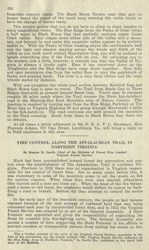
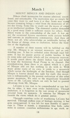
102 forgotten country roads. The Black Horse Tavern near that gap no longer heard the sound of the coach horn warning the stable hands to have the change of horses ready. This section proves that you do not have to climb to dizzy heights to enjoy magnificent views. The Blue Ridge from the Peaks of Otter forms a half moon to Black Horse Gap that partially encloses upper Goose Creek valley. Spur ridges down either side of the valley and a mountain just beyond its end make this exquisite valley appear to be entirely walled in. With the Peaks of Otter looming above the northeastern wall and the light and shadow playing across the woods and fields of the valley as you walk north toward Bearwallow Gap, you will be inclined to ignore everything else if the Trail will let you. By switching you to the western side a little, however, it reminds you that the Valley of Virginia is always a lovely sight. Here it has narrowed down as the Alleghenies and the Blue Ridge have come closer together. More hills and spur mountains rise from the valley floor to vary the patchwork of farms and grazing lands. The river is a very faint ribbon and the train whistle muted by distance. With one exception the whole trail section between Rockfish Gap and Black Horse Gap is open to travel. The Trail from Reeds Gap to Three Ridges dead-ends at present beyond Reeds Gap. Travel may be resumed roughly 20 miles south where the Trail crosses the State fish-hatchery road in the Maintop-Spy Rock Mountain area of Nelson County. This junction is reached by turning east from the Blue Ridge Parkway at Tye River Gap on Virginia Highway 56 and going through Montebello 4 miles to the fish-hatchery. The road continues one mile around the mountain to the Trail crossing. South from there to Black Horse Gap there are no detours. At all times a letter addressed to the N. B. A. T. C. Secretary, Miss Florence Adams, 707 Clay Street, Lynchburg, Va., will bring a reply as to Trail conditions in this area. Much has been accomplished toward forest fire prevention and control since the establishment of The Appalachian Trail in northern Virginia. Previous to 1915 there was no organization in Virginia responsible for the control of forest fires. Not so many years before this, it was customary in some of the mountain areas to set the woods on fire for various reasons. When these fires were once started, oftentimes they burned until a rain put them out. When the head of the fire threatened a home or rail fence, the neighbors would deflect its course by backfiring a road or branch. Seldom did they attempt to control the entire In the early part of the twentieth century, the people at last became alarmed because of the vast acreage of timbered land that was being consumed each year by uncontrolled forest fires, and in 1915 the Virginia Forest Service was created by an act of the General Assembly. A State Forester was appointed and given the responsibility of organizing the State by counties into fire-fighting units. The General Assembly also passed a number of laws supporting the State Forester in his efforts to prevent careless or irresponsible persons from setting the woods on fire. ially in the "Northern'v'i'' ',"'"""I ','"'|v"',,'"",i H-c>res* Service T " me of the Bulletin. field of fire prevention, see the article entitled "The Virginia Forest S( the Blue Ridge Area in Northern Virginia," by Berlin Eye, published
Object
Object’s are ‘parent’ level descriptions to ‘children’ items, (e.g. a book with pages).
-
This 1946 bulletin by the Potomac Appalachian Trail Club includes (pages 104-108) a 1910 letter to Horace Kephart from A.A. Chable who wrote of his “tramping, camping, and mountain climbing” in the Smokies. Horace Kephart (1862-1931) was a noted naturalist, woodsman, journalist, and author and promoter of the Great Smoky Mountains National Park.
-
Related items
-
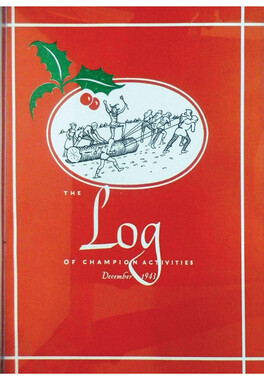
The Log Vol. 29 No. 05
-
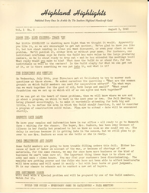
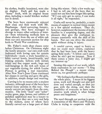
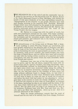
Highland Highlights 1942, August
-
John C. Campbell Folk School, no. 15 (May 1933)
-
John C. Campbell Folk School, no. 11 (April 1931)

-
The Reporter, June 2008

-
Mountain Milestones, Vol. 1, No. 2 page 4
-
The Log Vol. 25 No. 11
-
The Reporter, March 1973

-
The Reporter, November 2002

-
The Log Vol. 9 No. 03

-
The Log Vol. 3 No. 08
-
Appalachian Trail Club bulletin
-
John C. Campbell Folk School, no. 17 (April 1935)
-
The Log Vol. 37 No. 03

-
Hardwood Bark, 1929
-
The Reporter, April 2002

-
The Log Vol. 43 No. 05

-
John C. Campbell Folk School, no. 18 (November 1935)

-
Hardwood Bark, 1926
-
John C. Campbell Folk School, no. 28 (May 1944)
-
The Log Vol. 3 No. 10
-
The Log Vol. 1 No. 11

-
The Reporter, November 1982

-
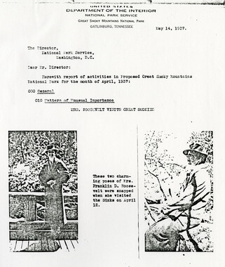
First Lady Eleanor Roosevelt Visits Smokies
-
The Log Vol. 3 No. 10

-
The Log Vol. 42 No. 06

-
The Log Vol. 17 No. 03 (1935)

-
The Reporter, April 1980

-
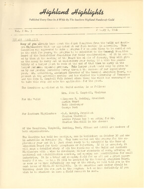
Highland Highlights 1944, January
-
The Log Vol. 30 No. 04
-
The Log Vol. 36 No. 07

-
The Log Vol. 38 No. 10

Part of Collection
Great Smoky Mountains - A Park for America
-
Memories of District C: Civilian Conservation Corps

-
Appalachian National Park: Synopsis of work accomplished

-
Editorial: The Century magazine

-
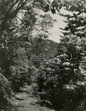
Rhododendron along trail
-
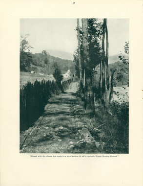
Jump Off

-
Financial receipts and expenditures, 1899

-
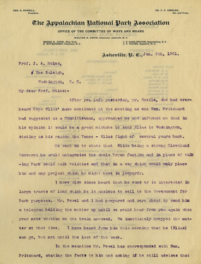
Travel to Washington D.C.
-
Federal court records: Latimer v. Poteet, Meigs Post

-
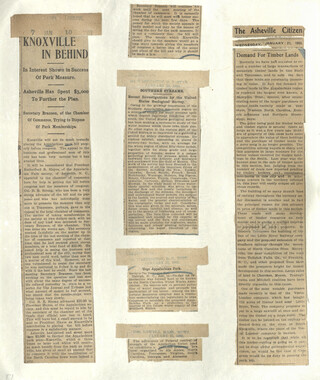
Appalachian National Park Association Newspaper Clippings, 1902-1907, 1925, 1928
-
Report of the North Carolina Park Commission

-
Great Smoky Mountains
-
Henry Arvel Greene and Jane Patton Greene

-
Financial receipts and expenditures, 1900
-
Civilian Conservation Corps Annual: District "C"

-
Hikers on the trail to Gregory Bald

-
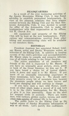
Program of hikes for 1930/ Smoky Mountains Hiking Club
-
Report of the North Carolina Park Commission

-
Trip into the Smokies with Horace Kephart

-
Report of the Secretary of Agriculture in relation to the forests, rivers, and mountains of the southern Appalachian region
-
Appalachian National Park Association Newspaper Clippings, 1902-1907, 1925, 1928

-
CCC enrollees: Will Blevins and Willard Jeri Riis
-
Corn crib doors, Deep Creek, N.C.

-
Report of the Secretary of Agriculture in relation to the forests, rivers, and mountains of the southern Appalachian region

-
Cataloochee tract 233: W. B. Bennett
-
Speech in support of an Appalachian National Park
-
Activities of the Appalachian National Park Association and the Appalachian National Forest Reserve Association: 1899-1906
-
Secretary of Agriculture report on watersheds
-
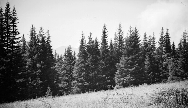
View from Grassy Bald
-
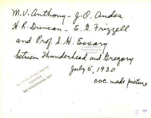
Hikers between Thunderhead and Gregory
-
Cataloochee tract 254: W. D. Messer

-
Handbook/ 1931/ Smoky Mountains Hiking Club
-
Cataloochee tract 212: Thomas Caldwell
