- Canton Champion Fibre Company (2308)
- Cherokee Traditions (291)
- Civil War in Southern Appalachia (165)
- Craft Revival (1942)
- Great Smoky Mountains - A Park for America (2946)
- Highlights from Western Carolina University (430)
- Horace Kephart (941)
- Journeys Through Jackson (159)
- LGBTQIA+ Archive of Jackson County (85)
- Oral Histories of Western North Carolina (314)
- Picturing Appalachia (6798)
- Stories of Mountain Folk (413)
- Travel Western North Carolina (160)
- Western Carolina University Fine Art Museum Vitreograph Collection (129)
- Western Carolina University Herbarium (92)
- Western Carolina University: Making Memories (708)
- Western Carolina University Publications (2412)
- Western Carolina University Restricted Electronic Theses and Dissertations (146)
- Western North Carolina Regional Maps (71)
- World War II in Southern Appalachia (131)
- Appalachian National Park Association (53)
- Berry, Walter (76)
- Champion Fibre Company (5)
- Fromer, Irving Rhodes, 1913-1994 (70)
- Grant, George Alexander, 1891-1964 (96)
- Kephart, Horace, 1862-1931 (23)
- Masa, George, 1881-1933 (17)
- North Carolina Park Commission (105)
- Roth, Albert, 1890-1974 (142)
- Schenck, Carl Alwin, 1868-1955 (1)
- Stearns, I. K. (2)
- Thompson, James Edward, 1880-1976 (45)
- Weaver, Zebulon, 1872-1948 (55)
- Wilburn, Hiram Coleman, 1880-1967 (72)
- Allanstand Cottage Industries (0)
- Bennett, Kelly, 1890-1974 (0)
- Brasstown Carvers (0)
- Cain, Doreyl Ammons (0)
- Carver, George Washington, 1864?-1943 (0)
- Cathey, Joseph, 1803-1874 (0)
- Champion Paper and Fibre Company (0)
- Cherokee Indian Fair Association (0)
- Cherokee Language Program (0)
- Crittenden, Lorraine (0)
- Crowe, Amanda (0)
- Edmonston, Thomas Benton, 1842-1907 (0)
- Ensley, A. L. (Abraham Lincoln), 1865-1948 (0)
- George Butz (BFS 1907) (0)
- Goodrich, Frances Louisa (0)
- Heard, Marian Gladys (0)
- Kephart, Calvin, 1883-1969 (0)
- Kephart, Laura, 1862-1954 (0)
- Laney, Gideon Thomas, 1889-1976 (0)
- McElhinney, William Julian, 1896-1953 (0)
- Niggli, Josephina, 1910-1983 (0)
- Osborne, Kezia Stradley (0)
- Owens, Samuel Robert, 1918-1995 (0)
- Penland Weavers and Potters (0)
- Rhodes, Judy (0)
- Roberts, Vivienne (0)
- Sherrill's Photography Studio (0)
- Smith, Edward Clark (0)
- Southern Highland Handicraft Guild (0)
- Southern Highlanders, Inc. (0)
- Stalcup, Jesse Bryson (0)
- United States. Indian Arts and Crafts Board (0)
- USFS (0)
- Vance, Zebulon Baird, 1830-1894 (0)
- Western Carolina College (0)
- Western Carolina Teachers College (0)
- Western Carolina University (0)
- Western Carolina University. Mountain Heritage Center (0)
- Whitman, Walt, 1819-1892 (0)
- Williams, Isadora (0)
- 1810s (1)
- 1840s (1)
- 1850s (2)
- 1860s (3)
- 1870s (4)
- 1880s (7)
- 1890s (64)
- 1900s (294)
- 1910s (227)
- 1920s (461)
- 1930s (1765)
- 1940s (82)
- 1950s (15)
- 1960s (13)
- 1970s (47)
- 1980s (14)
- 1990s (16)
- 2000s (31)
- 2010s (1)
- 1600s (0)
- 1700s (0)
- 1800s (0)
- 1820s (0)
- 1830s (0)
- 2020s (0)
- Appalachian Region, Southern (81)
- Asheville (N.C.) (3)
- Avery County (N.C.) (6)
- Blount County (Tenn.) (193)
- Buncombe County (N.C.) (204)
- Cherokee County (N.C.) (10)
- Clay County (N.C.) (3)
- Graham County (N.C.) (108)
- Great Smoky Mountains National Park (N.C. and Tenn.) (447)
- Haywood County (N.C.) (305)
- Henderson County (N.C.) (13)
- Jackson County (N.C.) (58)
- Knox County (Tenn.) (31)
- Knoxville (Tenn.) (12)
- Lake Santeetlah (N.C.) (10)
- Macon County (N.C.) (25)
- Madison County (N.C.) (17)
- McDowell County (N.C.) (5)
- Mitchell County (N.C.) (7)
- Polk County (N.C.) (2)
- Qualla Boundary (22)
- Rutherford County (N.C.) (16)
- Swain County (N.C.) (533)
- Transylvania County (N.C.) (36)
- Watauga County (N.C.) (2)
- Waynesville (N.C.) (2)
- Yancey County (N.C.) (34)
- Aerial Views (3)
- Articles (1)
- Artifacts (object Genre) (4)
- Bibliographies (1)
- Clippings (information Artifacts) (77)
- Drawings (visual Works) (174)
- Envelopes (2)
- Financial Records (9)
- Fliers (printed Matter) (34)
- Guidebooks (1)
- Interviews (15)
- Land Surveys (102)
- Letters (correspondence) (219)
- Manuscripts (documents) (90)
- Maps (documents) (86)
- Memorandums (14)
- Minutes (administrative Records) (20)
- Negatives (photographs) (462)
- Newsletters (12)
- Paintings (visual Works) (1)
- Pen And Ink Drawings (1)
- Photographs (1657)
- Portraits (95)
- Postcards (15)
- Publications (documents) (107)
- Scrapbooks (3)
- Sheet Music (1)
- Songs (musical Compositions) (2)
- Sound Recordings (7)
- Speeches (documents) (11)
- Transcripts (46)
- Aerial Photographs (0)
- Albums (books) (0)
- Biography (general Genre) (0)
- Cards (information Artifacts) (0)
- Copybooks (instructional Materials) (0)
- Crafts (art Genres) (0)
- Depictions (visual Works) (0)
- Design Drawings (0)
- Exhibitions (events) (0)
- Facsimiles (reproductions) (0)
- Fiction (general Genre) (0)
- Glass Plate Negatives (0)
- Internegatives (0)
- Newspapers (0)
- Notebooks (0)
- Occupation Currency (0)
- Periodicals (0)
- Personal Narratives (0)
- Plans (maps) (0)
- Poetry (0)
- Programs (documents) (0)
- Questionnaires (0)
- Relief Prints (0)
- Sayings (literary Genre) (0)
- Slides (photographs) (0)
- Specimens (0)
- Text Messages (0)
- Tintypes (photographs) (0)
- Video Recordings (physical Artifacts) (0)
- Appalachian National Park Association Records (336)
- Carlos C. Campbell Collection (462)
- Cataloochee History Project (64)
- George Masa Collection (89)
- Hiram C. Wilburn Papers (28)
- Historic Photographs Collection (236)
- Horace Kephart Collection (126)
- Humbard Collection (33)
- Jim Thompson Collection (44)
- Love Family Papers (11)
- Map Collection (12)
- R.A. Romanes Collection (10)
- Smoky Mountains Hiking Club Collection (616)
- Zebulon Weaver Collection (107)
- A.L. Ensley Collection (0)
- Appalachian Industrial School Records (0)
- Axley-Meroney Collection (0)
- Bayard Wootten Photograph Collection (0)
- Bethel Rural Community Organization Collection (0)
- Blumer Collection (0)
- C.W. Slagle Collection (0)
- Canton Area Historical Museum (0)
- Cherokee Studies Collection (0)
- Daisy Dame Photograph Album (0)
- Daniel Boone VI Collection (0)
- Doris Ulmann Photograph Collection (0)
- Elizabeth H. Lasley Collection (0)
- Elizabeth Woolworth Szold Fleharty Collection (0)
- Frank Fry Collection (0)
- Gideon Laney Collection (0)
- Hazel Scarborough Collection (0)
- Hunter and Weaver Families Collection (0)
- I. D. Blumenthal Collection (0)
- Isadora Williams Collection (0)
- Jesse Bryson Stalcup Collection (0)
- John B. Battle Collection (0)
- John C. Campbell Folk School Records (0)
- John Parris Collection (0)
- Judaculla Rock project (0)
- Kelly Bennett Collection (0)
- Major Wiley Parris Civil War Letters (0)
- McFee-Misemer Civil War Letters (0)
- Mountain Heritage Center Collection (0)
- Norburn - Robertson - Thomson Families Collection (0)
- Pauline Hood Collection (0)
- Pre-Guild Collection (0)
- Qualla Arts and Crafts Mutual Collection (0)
- Rosser H. Taylor Collection (0)
- Samuel Robert Owens Collection (0)
- Sara Madison Collection (0)
- Sherrill Studio Photo Collection (0)
- Stories of Mountain Folk - Radio Programs (0)
- The Reporter, Western Carolina University (0)
- Venoy and Elizabeth Reed Collection (0)
- WCU Gender and Sexuality Oral History Project (0)
- WCU Mountain Heritage Center Oral Histories (0)
- WCU Oral History Collection - Mountain People, Mountain Lives (0)
- WCU Students Newspapers Collection (0)
- Western North Carolina Tomorrow Black Oral History Project (0)
- William Williams Stringfield Collection (0)
- Appalachian Trail (22)
- Church buildings (9)
- Civilian Conservation Corps (U.S.) (92)
- Dams (21)
- Floods (1)
- Forest conservation (11)
- Forests and forestry (42)
- Great Smoky Mountains National Park (N.C. and Tenn.) (82)
- Hunting (2)
- Logging (29)
- Maps (73)
- North Carolina -- Maps (5)
- Postcards (15)
- Railroad trains (8)
- Sports (4)
- Storytelling (2)
- Waterfalls -- Great Smoky Mountains (N.C. and Tenn.) (39)
- African Americans (0)
- Artisans (0)
- Cherokee art (0)
- Cherokee artists -- North Carolina (0)
- Cherokee language (0)
- Cherokee pottery (0)
- Cherokee women (0)
- College student newspapers and periodicals (0)
- Dance (0)
- Education (0)
- Folk music (0)
- Forced removal, 1813-1903 (0)
- Gender nonconformity (0)
- Landscape photography (0)
- Mines and mineral resources (0)
- Paper industry (0)
- Pottery (0)
- Rural electrification -- North Carolina, Western (0)
- School integration -- Southern States (0)
- Segregation -- North Carolina, Western (0)
- Slavery (0)
- Weaving -- Appalachian Region, Southern (0)
- Wood-carving -- Appalachian Region, Southern (0)
- World War, 1939-1945 (0)
- Sound (7)
- StillImage (2352)
- Text (654)
- MovingImage (0)
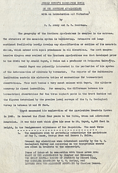
Guyot's geographic notes on the southern Appalachians
Guyot's geographic notes on the southern Appalachians
GSMNP_13150_25_1067_01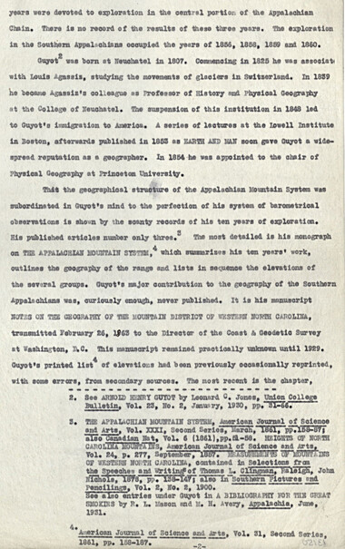
Guyot's geographic notes on the southern Appalachians
GSMNP_13150_25_1067_02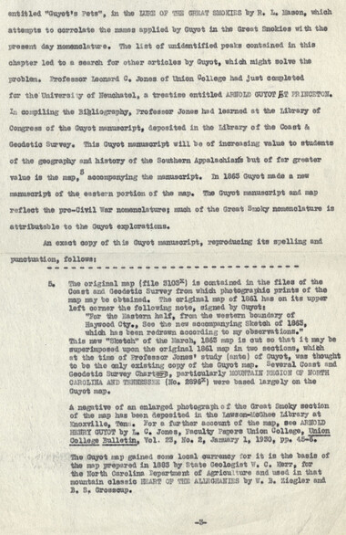
Guyot's geographic notes on the southern Appalachians
GSMNP_13150_25_1067_03
Guyot's geographic notes on the southern Appalachians
GSMNP_13150_25_1067_04
Guyot's geographic notes on the southern Appalachians
GSMNP_13150_25_1067_05
Guyot's geographic notes on the southern Appalachians
GSMNP_13150_25_1067_06
Guyot's geographic notes on the southern Appalachians
GSMNP_13150_25_1067_07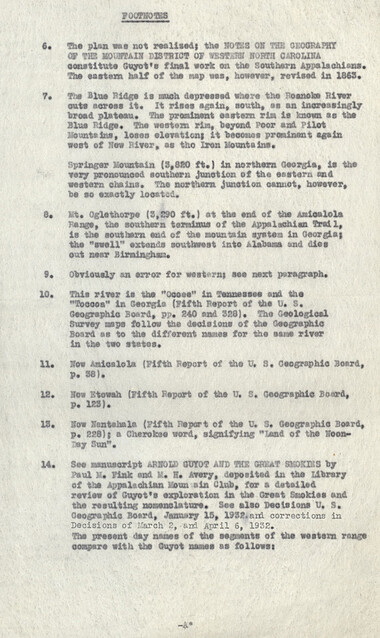
Guyot's geographic notes on the southern Appalachians
GSMNP_13150_25_1067_08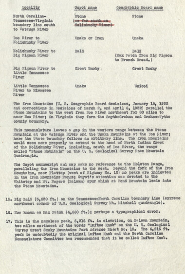
Guyot's geographic notes on the southern Appalachians
GSMNP_13150_25_1067_09
Guyot's geographic notes on the southern Appalachians
GSMNP_13150_25_1067_10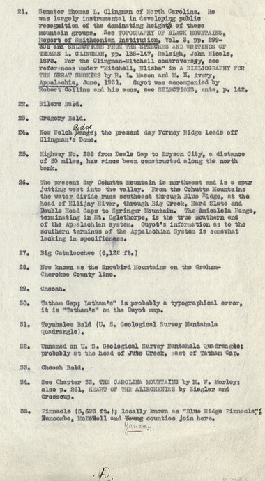
Guyot's geographic notes on the southern Appalachians
GSMNP_13150_25_1067_11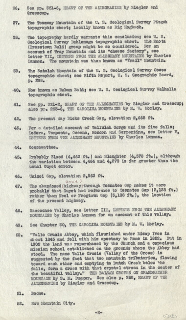
Guyot's geographic notes on the southern Appalachians
GSMNP_13150_25_1067_12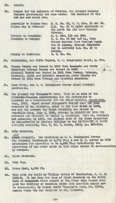
Guyot's geographic notes on the southern Appalachians
GSMNP_13150_25_1067_13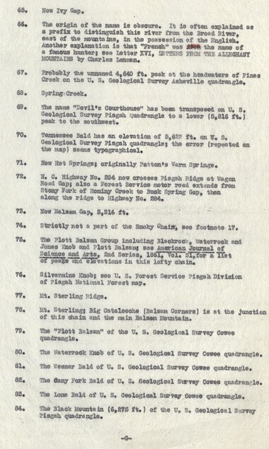
Guyot's geographic notes on the southern Appalachians
GSMNP_13150_25_1067_14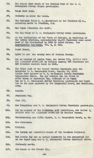
Guyot's geographic notes on the southern Appalachians
GSMNP_13150_25_1067_15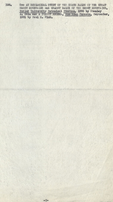
Guyot's geographic notes on the southern Appalachians
GSMNP_13150_25_1067_16Item’s are ‘child’ level descriptions to ‘parent’ objects, (e.g. one page of a whole book).
-
-
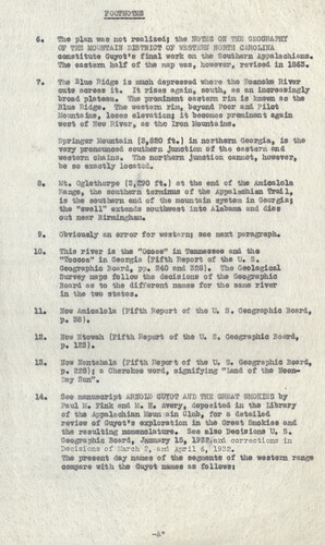
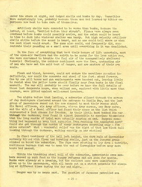
FOOTNOTES 6. The plan was not realised! the NOTES ON THE OKOORARBY. OF THE MOUNTAIN V.ffiTRICT OF WESTERN NORTH CAROLINA constitute Guyot*s final work on the Southern Appalachians. The eastern half of the map waa, however, revised in 1863. 7. frte Blue Ridge is much depressed where the Roanoke River outs across it. It rises again, south, as an increasingly broad plateau. The prominent eastern rim is known as the Blue Ridge. The western rim, beyond Poor and Pilot Mountains, loses elevationj it becomes prominent again vest of Hew River, as tho Iron Mountains. dinger Mountain (3,820 ft.) in northern Georgia, is the very pronounced southern Junction of the eastern and western chains. The northern junction cannot, however, be so exactly located. 8. Mt. Oglethorpe (3,290 ft.) at the end of the Aiaioalola Range, the southern terminus of the Appalachian Trail, is the southern end of the mountain system in Georgia % the "swell" extends southwest into Alabama and dies out near Birmingham. 9. Obviously an error for western* see next paragraph. 10. This river Is the "Oooee" in Tennessee and the "Toaooa" in Georgia (Fifth Report of the b. s. Geographic Board, pp. 240 and 328}. The Geological Survey asps follow the decisions of the Geographic Board as to the different names for the same river in the two states. 11. Now Amioalola (Fifth Report of the U. S. Geographic Board, p. 38). 12. Now Etowah (Fifth Report of the U. S, Geographic Board, p. 123). 13. Now Nentahala (Fifth Report of the U. S. GeographiO Board, p. 228) { a Cherokee word, signifying "Land of ths Noon- Day Sun". 14. See manuscript iiRNOED GOT0T AND THE GHEaT SH3KXB9 by Paul M, Fink and M. H. Avery, deposited in the Library of the Appalachian Koun ain Club, for a detailed review of Guyot's exploration in the Great Smokies end the resulting nomenclature. See also Decisions U. S. Osographlc Board, January 15, 1932*and corrections in Decisions of LTarch 2,-and April 6, 1932. The present day names of the segments of the westsrn range oorapsre with the Guyot names as follows? -V
Object’s are ‘parent’ level descriptions to ‘children’ items, (e.g. a book with pages).
-
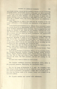
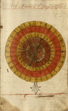
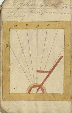
This 16-page manuscript recounts the involvement of Arnold Guyot in the Great Smoky Mountains. A geologist and geographer, Arnold Henry Guyot (1807-1884), began his exploration of the Appalachians in 1849. His purpose was to record the elevations of various peaks and develop a systematic geographic outline of the mountain systems of the eastern United States. The manuscript was collected by George Masa. Born Masahara Iizuka and raised in Japan, George Masa (1881-1933) emigrated to the U.S. when he was 20 years old and, in 1915, came to Asheville, where he lived the rest of his life. Masa was active in the Appalachian Trail Club and in the movement to establish the Great Smoky Mountains National Park. Myron Haliburton Avery (1899–1952), who was president of the Potomac Appalachian Trail Club and chairman of the board of the Appalachian Trail Conference.
-
Related items
-
Account of the USS Canopus written by Capt. E. L. Sackett

-
Camping and Woodcraft draft page

-
Songs Written By from "The Spinning Wheel" Girls
-
William Twaddell Copybook, 1758

-
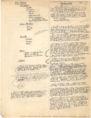
Chap. Review. Background
-
Proposition to purchase land

-
The Canopus
-
Activities of the Appalachian National Park Association and the Appalachian National Forest Reserve Association: 1899-1906
-
Aboard ship on way to States by Carr Hooper
-
William Twaddell copybook, 1761-1762

-
Guyot and the Great Smokies

-
William Twaddell Copybook, 1758

-
Nomenclature notes: place names in Smokies

-
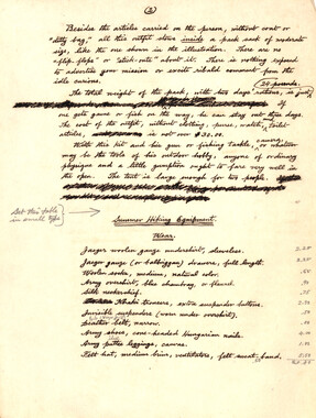
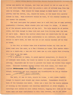
Pedestrian Equipment
-
William Twaddell copybook, 1761-1762
-
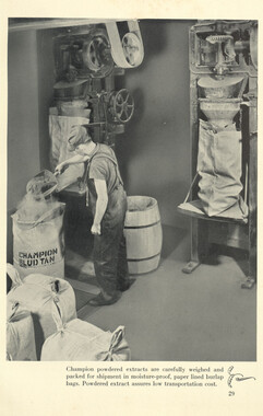
The story of chestnut extract
-
Anderson Copy Book
-
Camping and Woodcraft Notes Index - 20-157

-
Weaving and dyeing in western North Carolina

-
The Canopus
-
Civil War Diary of Absalom Joshua Burum

-
Camping and Woodcraft draft page

-
Inventory of Horace Kephart collection

-
Horace Kephart Journal 13

-
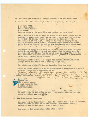
Vegetable Dyes - Handicraft School, Penland, N. C.
-
Nomenclature notes: place names in N. C.
-
The story of chestnut extract

-
Cataloochee tract 255: Levi N. Hall

-
Camping and Woodcraft draft page
-
The story of chestnut extract
-
William Twaddell Copybook, 1758
Part of Collection
Great Smoky Mountains - A Park for America
-
Cataloochee tract 287: James Jenkins

-
Charlies Bunion and Mount LeConte

-
Requests for information on Appalachian National Park

-
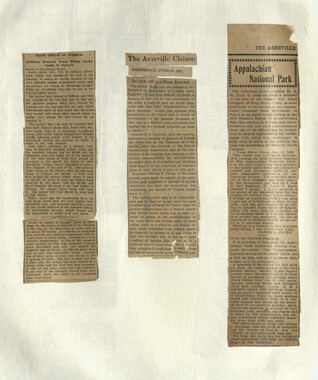
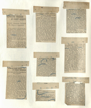
Appalachian National Park Association Newspaper Clippings, 1899-1902
-
Mount Guyot and Mount Chapman
-
Appalachian National Park: Synopsis of work accomplished

-
Appalachian National Park Association Newspaper Clippings, 1902-1907, 1925, 1928
-
Nomenclature notes: place names in N. C.

-
Cataloochee tract 212a: Thomas Caldwell
-
Correspondence between Zebulon Weaver, Fred L. Weede, W. H. Woodbury, David C. Chapman, Mark Squires, Junius G. Adams, March 1932

-
Appalachian National Park Association Newspaper Clippings, 1902-1907, 1925, 1928

-
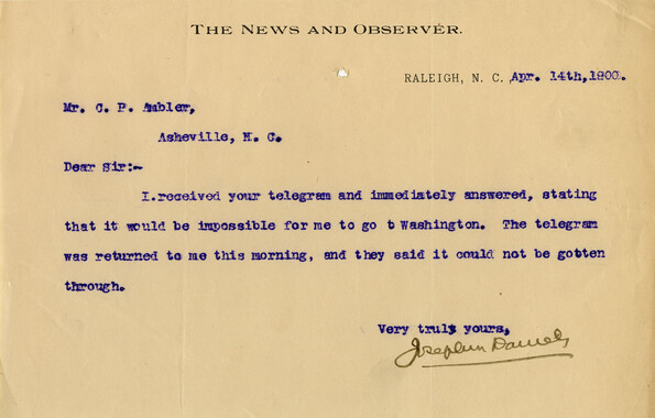
Correspondence regarding organizational meetings, 1899

-
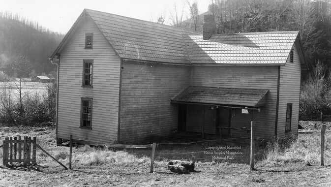
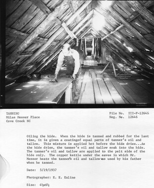
Cataloochee Cove Creek - Milas Messer
-
Letters supporting Appalachian National Park movement
-
Report of the North Carolina Park Commission
-
Yellow poplar

-
Financial receipts and expenditures, 1902

-
Photo Album of the Great Smokey Mountains

-
Appalachian National Park Association Newspaper Clippings, 1899-1902
-
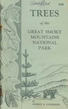
Trees of the Great Smoky Mountains National Park
-
Senate Committee on Agriculture presentation
-
Hardwood Bark, 1928

-
Appalachian National Park Association Newspaper Clippings, 1899-1902
-
Appalachian National Park Association Newspaper Clippings, 1899-1902

-
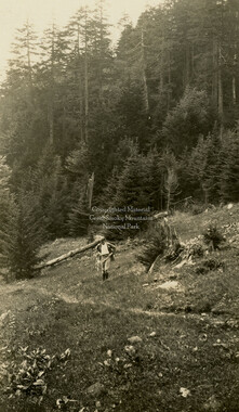
Hiker near Indian Gap
-
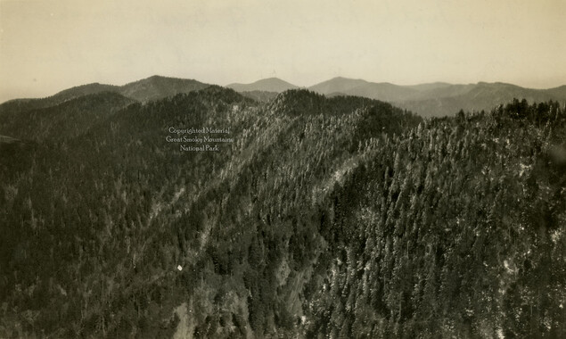
Sawteeth Range
-
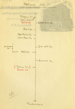
Nomenclature notes: N. C. stream diagrams with tributaries
-
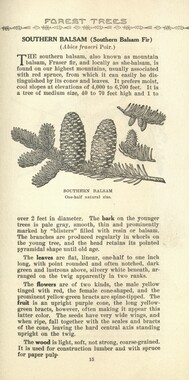
Common forest trees of North Carolina
-
Handbook/ 1931/ Smoky Mountains Hiking Club

-
Cataloochee tract 292: J. L. C. Messer
-
Financial record of Cash Receipts and Expenditures
-
Appalachian National Park Association Newspaper Clippings, 1902-1907, 1925, 1928