- Canton Champion Fibre Company (2308)
- Cherokee Traditions (291)
- Civil War in Southern Appalachia (165)
- Craft Revival (1942)
- Great Smoky Mountains - A Park for America (2946)
- Highlights from Western Carolina University (430)
- Horace Kephart (941)
- Journeys Through Jackson (159)
- LGBTQIA+ Archive of Jackson County (85)
- Oral Histories of Western North Carolina (314)
- Picturing Appalachia (6873)
- Stories of Mountain Folk (413)
- Travel Western North Carolina (160)
- Western Carolina University Fine Art Museum Vitreograph Collection (129)
- Western Carolina University Herbarium (92)
- Western Carolina University: Making Memories (738)
- Western Carolina University Publications (2491)
- Western Carolina University Restricted Electronic Theses and Dissertations (146)
- Western North Carolina Regional Maps (71)
- World War II in Southern Appalachia (131)
- Appalachian National Park Association (53)
- Berry, Walter (76)
- Champion Fibre Company (5)
- Fromer, Irving Rhodes, 1913-1994 (70)
- Grant, George Alexander, 1891-1964 (96)
- Kephart, Horace, 1862-1931 (23)
- Masa, George, 1881-1933 (17)
- North Carolina Park Commission (105)
- Roth, Albert, 1890-1974 (142)
- Schenck, Carl Alwin, 1868-1955 (1)
- Stearns, I. K. (2)
- Thompson, James Edward, 1880-1976 (45)
- Weaver, Zebulon, 1872-1948 (55)
- Wilburn, Hiram Coleman, 1880-1967 (72)
- Allanstand Cottage Industries (0)
- Bennett, Kelly, 1890-1974 (0)
- Brasstown Carvers (0)
- Cain, Doreyl Ammons (0)
- Carver, George Washington, 1864?-1943 (0)
- Cathey, Joseph, 1803-1874 (0)
- Champion Paper and Fibre Company (0)
- Cherokee Indian Fair Association (0)
- Cherokee Language Program (0)
- Crittenden, Lorraine (0)
- Crowe, Amanda (0)
- Edmonston, Thomas Benton, 1842-1907 (0)
- Ensley, A. L. (Abraham Lincoln), 1865-1948 (0)
- George Butz (BFS 1907) (0)
- Goodrich, Frances Louisa (0)
- Heard, Marian Gladys (0)
- Kephart, Calvin, 1883-1969 (0)
- Kephart, Laura, 1862-1954 (0)
- Laney, Gideon Thomas, 1889-1976 (0)
- McElhinney, William Julian, 1896-1953 (0)
- Niggli, Josephina, 1910-1983 (0)
- Osborne, Kezia Stradley (0)
- Owens, Samuel Robert, 1918-1995 (0)
- Penland Weavers and Potters (0)
- Rhodes, Judy (0)
- Roberts, Vivienne (0)
- Sherrill's Photography Studio (0)
- Smith, Edward Clark (0)
- Southern Highland Handicraft Guild (0)
- Southern Highlanders, Inc. (0)
- Stalcup, Jesse Bryson (0)
- United States. Indian Arts and Crafts Board (0)
- USFS (0)
- Vance, Zebulon Baird, 1830-1894 (0)
- Western Carolina College (0)
- Western Carolina Teachers College (0)
- Western Carolina University (0)
- Western Carolina University. Mountain Heritage Center (0)
- Whitman, Walt, 1819-1892 (0)
- Williams, Isadora (0)
- 1810s (1)
- 1840s (1)
- 1850s (2)
- 1860s (3)
- 1870s (4)
- 1880s (7)
- 1890s (64)
- 1900s (294)
- 1910s (227)
- 1920s (461)
- 1930s (1765)
- 1940s (82)
- 1950s (15)
- 1960s (13)
- 1970s (47)
- 1980s (14)
- 1990s (16)
- 2000s (31)
- 2010s (1)
- 1600s (0)
- 1700s (0)
- 1800s (0)
- 1820s (0)
- 1830s (0)
- 2020s (0)
- Appalachian Region, Southern (81)
- Asheville (N.C.) (3)
- Avery County (N.C.) (6)
- Blount County (Tenn.) (193)
- Buncombe County (N.C.) (204)
- Cherokee County (N.C.) (10)
- Clay County (N.C.) (3)
- Graham County (N.C.) (108)
- Great Smoky Mountains National Park (N.C. and Tenn.) (447)
- Haywood County (N.C.) (305)
- Henderson County (N.C.) (13)
- Jackson County (N.C.) (58)
- Knox County (Tenn.) (31)
- Knoxville (Tenn.) (12)
- Lake Santeetlah (N.C.) (10)
- Macon County (N.C.) (25)
- Madison County (N.C.) (17)
- McDowell County (N.C.) (5)
- Mitchell County (N.C.) (7)
- Polk County (N.C.) (2)
- Qualla Boundary (22)
- Rutherford County (N.C.) (16)
- Swain County (N.C.) (533)
- Transylvania County (N.C.) (36)
- Watauga County (N.C.) (2)
- Waynesville (N.C.) (2)
- Yancey County (N.C.) (34)
- Aerial Views (3)
- Articles (1)
- Artifacts (object Genre) (4)
- Bibliographies (1)
- Clippings (information Artifacts) (77)
- Drawings (visual Works) (174)
- Envelopes (2)
- Financial Records (9)
- Fliers (printed Matter) (34)
- Guidebooks (1)
- Interviews (15)
- Land Surveys (102)
- Letters (correspondence) (219)
- Manuscripts (documents) (90)
- Maps (documents) (86)
- Memorandums (14)
- Minutes (administrative Records) (20)
- Negatives (photographs) (462)
- Newsletters (12)
- Paintings (visual Works) (1)
- Pen And Ink Drawings (1)
- Photographs (1657)
- Portraits (95)
- Postcards (15)
- Publications (documents) (107)
- Scrapbooks (3)
- Sheet Music (1)
- Songs (musical Compositions) (2)
- Sound Recordings (7)
- Speeches (documents) (11)
- Transcripts (46)
- Aerial Photographs (0)
- Albums (books) (0)
- Biography (general Genre) (0)
- Cards (information Artifacts) (0)
- Copybooks (instructional Materials) (0)
- Crafts (art Genres) (0)
- Depictions (visual Works) (0)
- Design Drawings (0)
- Exhibitions (events) (0)
- Facsimiles (reproductions) (0)
- Fiction (general Genre) (0)
- Glass Plate Negatives (0)
- Internegatives (0)
- Newspapers (0)
- Notebooks (0)
- Occupation Currency (0)
- Periodicals (0)
- Personal Narratives (0)
- Plans (maps) (0)
- Poetry (0)
- Programs (documents) (0)
- Questionnaires (0)
- Relief Prints (0)
- Sayings (literary Genre) (0)
- Slides (photographs) (0)
- Specimens (0)
- Text Messages (0)
- Tintypes (photographs) (0)
- Video Recordings (physical Artifacts) (0)
- Appalachian National Park Association Records (336)
- Carlos C. Campbell Collection (462)
- Cataloochee History Project (64)
- George Masa Collection (89)
- Hiram C. Wilburn Papers (28)
- Historic Photographs Collection (236)
- Horace Kephart Collection (126)
- Humbard Collection (33)
- Jim Thompson Collection (44)
- Love Family Papers (11)
- Map Collection (12)
- R.A. Romanes Collection (10)
- Smoky Mountains Hiking Club Collection (616)
- Zebulon Weaver Collection (107)
- A.L. Ensley Collection (0)
- Appalachian Industrial School Records (0)
- Axley-Meroney Collection (0)
- Bayard Wootten Photograph Collection (0)
- Bethel Rural Community Organization Collection (0)
- Blumer Collection (0)
- C.W. Slagle Collection (0)
- Canton Area Historical Museum (0)
- Cherokee Studies Collection (0)
- Daisy Dame Photograph Album (0)
- Daniel Boone VI Collection (0)
- Doris Ulmann Photograph Collection (0)
- Elizabeth H. Lasley Collection (0)
- Elizabeth Woolworth Szold Fleharty Collection (0)
- Frank Fry Collection (0)
- Gideon Laney Collection (0)
- Hazel Scarborough Collection (0)
- Hunter and Weaver Families Collection (0)
- I. D. Blumenthal Collection (0)
- Isadora Williams Collection (0)
- Jesse Bryson Stalcup Collection (0)
- John B. Battle Collection (0)
- John C. Campbell Folk School Records (0)
- John Parris Collection (0)
- Judaculla Rock project (0)
- Kelly Bennett Collection (0)
- Major Wiley Parris Civil War Letters (0)
- McFee-Misemer Civil War Letters (0)
- Mountain Heritage Center Collection (0)
- Norburn - Robertson - Thomson Families Collection (0)
- Pauline Hood Collection (0)
- Pre-Guild Collection (0)
- Qualla Arts and Crafts Mutual Collection (0)
- Rosser H. Taylor Collection (0)
- Samuel Robert Owens Collection (0)
- Sara Madison Collection (0)
- Sherrill Studio Photo Collection (0)
- Stories of Mountain Folk - Radio Programs (0)
- The Reporter, Western Carolina University (0)
- Venoy and Elizabeth Reed Collection (0)
- WCU Gender and Sexuality Oral History Project (0)
- WCU Mountain Heritage Center Oral Histories (0)
- WCU Oral History Collection - Mountain People, Mountain Lives (0)
- WCU Students Newspapers Collection (0)
- Western North Carolina Tomorrow Black Oral History Project (0)
- William Williams Stringfield Collection (0)
- Appalachian Trail (22)
- Church buildings (9)
- Civilian Conservation Corps (U.S.) (92)
- Dams (21)
- Floods (1)
- Forest conservation (11)
- Forests and forestry (42)
- Great Smoky Mountains National Park (N.C. and Tenn.) (82)
- Hunting (2)
- Logging (29)
- Maps (73)
- North Carolina -- Maps (5)
- Postcards (15)
- Railroad trains (8)
- Sports (4)
- Storytelling (2)
- Waterfalls -- Great Smoky Mountains (N.C. and Tenn.) (39)
- African Americans (0)
- Artisans (0)
- Cherokee art (0)
- Cherokee artists -- North Carolina (0)
- Cherokee language (0)
- Cherokee pottery (0)
- Cherokee women (0)
- College student newspapers and periodicals (0)
- Dance (0)
- Education (0)
- Folk music (0)
- Forced removal, 1813-1903 (0)
- Gender nonconformity (0)
- Landscape photography (0)
- Mines and mineral resources (0)
- Paper industry (0)
- Pottery (0)
- Rural electrification -- North Carolina, Western (0)
- School integration -- Southern States (0)
- Segregation -- North Carolina, Western (0)
- Slavery (0)
- Weaving -- Appalachian Region, Southern (0)
- Wood-carving -- Appalachian Region, Southern (0)
- World War, 1939-1945 (0)
- Sound (7)
- StillImage (2352)
- Text (654)
- MovingImage (0)
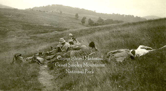
Early Explorers in the Great Smokies
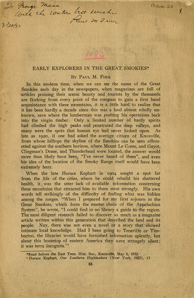
Early Explorers in the Great Smokies
GSMNP_13150_19_1185_01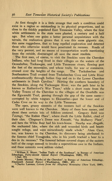
Early Explorers in the Great Smokies
GSMNP_13150_19_1185_02
Early Explorers in the Great Smokies
GSMNP_13150_19_1185_03
Early Explorers in the Great Smokies
GSMNP_13150_19_1185_04
Early Explorers in the Great Smokies
GSMNP_13150_19_1185_05
Early Explorers in the Great Smokies
GSMNP_13150_19_1185_06
Early Explorers in the Great Smokies
GSMNP_13150_19_1185_07
Early Explorers in the Great Smokies
GSMNP_13150_19_1185_08
Early Explorers in the Great Smokies
GSMNP_13150_19_1185_09
Early Explorers in the Great Smokies
GSMNP_13150_19_1185_10
Early Explorers in the Great Smokies
GSMNP_13150_19_1185_11
Early Explorers in the Great Smokies
GSMNP_13150_19_1185_12
Early Explorers in the Great Smokies
GSMNP_13150_19_1185_13
Early Explorers in the Great Smokies
GSMNP_13150_19_1185_14
Early Explorers in the Great Smokies
GSMNP_13150_19_1185_15
Early Explorers in the Great Smokies
GSMNP_13150_19_1185_16Item’s are ‘child’ level descriptions to ‘parent’ objects, (e.g. one page of a whole book).
-
-
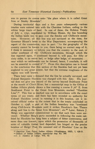
60 East Tennessee Historical Society's Publications was to pursue its course unto "the place where it is called Great Iron or Smoky Mountain". During territorial days and a few years subsequently various treaties were entered into with the Cherokee Indians, ceding to the whites large tracts of land. In one of these, the Holston Treaty of July 2, 1791, negotiated by William Blount, the line bounding the Indian lands was to pass over the Smoky and Chilhowie mountains. However, all this line was not surveyed at the time, for Governor Blount's letter to the War Department, accompanying the report of the commission, says in part: "As the* geography of the country cannot be known to you, there being no correct map of it, I think it necessary to inform you that the country to the east, or rather southeast of the Chilhowie -mountains, through which the line reported upon, if continued beyond it, will pass, for fifty or sixty miles, is an entire bed, or ledge after ledge, of mountains. . . near which no settlements can be formed, hence, I conclude, it will not be essential to extend it".20 From this description one is forced to the conclusion that this section of the Smokies had not yet been explored to any great extent, but that the extreme roughness of the region was well known. There later came a demand that the line be actually surveyed, and Colonel Benjamin Hawkins was charged with this duty. His journal does not give any record of the survey beyond Southwest Point at the mouth of Clinch River, but a manuscript map in the Office of Indian Affairs plainly shows a line running a course S y6° E. from Southwest Point to the Great Iron Mountain, marked "Hawkins Line".21 This line as marked was not in accordance with the exact terms of any treaty, and there has been revealed no authority for Colonel Hawkins action in running it in this location, yet it received official notice to the extent that in the treaty concluded on October 2, 1798, a part of the Indian boundary was "continued along Chill-howie Mountain until it strikes Hawkins's line. Thence along said line to the Great Iron Mountain", etc.22 Later, Return J. Meigs was appointed commissioner to see that such lines were surveyed. Whether Meig's party succeeded in following the route outlined by Hawkins has long been a subject of bitter controversy, and more than one lawsuit, upon which the possession of thousands of acres of valuable timber land depended, has hinged on the precise location of Meigs' Post, the assumed end of Hawkins' Line on the 20 American State Paper, Indian Affairs (Washington, 1832), I, 628-31. 21 Officer of Indian Affairs, manuscript map No. 749. »U. S. Statutes at Large, VII, 62,
Object’s are ‘parent’ level descriptions to ‘children’ items, (e.g. a book with pages).
-
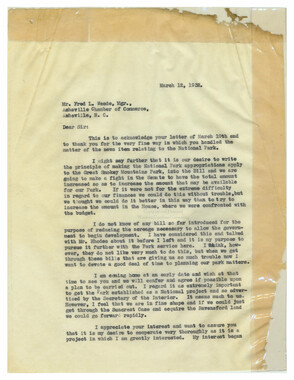
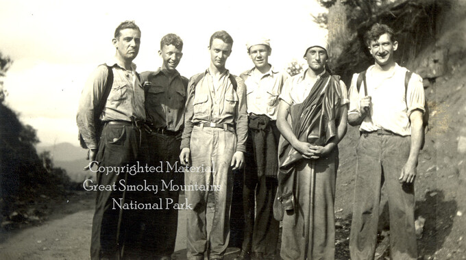
This article titled, “Early Explorers in the Great Smokies” was written by Paul Fink and published in the East Tennessee Historical Society’s Publications. Fink signed, dated, and inscribed this copy to George Masa. Born Masahara Iizuka and raised in Japan, George Masa (1881-1933) was active in the Appalachian Trail Club and in the movement to establish the Great Smoky Mountains National Park. Paul M. Fink (1892-1980), a hiker and advocate of the Great Smoky Mountains National Park, served on the Tennessee Nomenclature Committee. Working with George Masa and others, he was largely responsible for routing the Appalachian Trail through the Great Smokies and nearby mountain ranges.
-
Related items
-
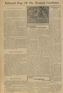
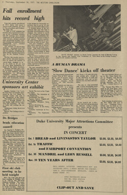
Western Carolinian, March 31, 1988 (Volume 53 Number 24)

-
Cullowhee Yodel Volume 04 Number 08
-
Western Carolinian Volume 68 Number 02
-
Western Carolinian Volume 35 Number 10
-
Western Carolinian Volume 70 Number 13
-
Western Carolinian Volume 77 Number 13

-
Western Carolinian Volume 70 Number 07
-
Western Carolinian Volume 45 Number 22
-
Western Carolinian Volume 52 Number 20, February 26, 1987

-
Memories of District C: Civilian Conservation Corps
-
Western Carolinian Volume 64 (65) Number 09
-
Cullowhee Yodel Volume 06 Number 05

-
Western Carolinian Volume 62 Number 22
-
Western Carolinian Volume 57 Number 07
-
Western North Carolina R. R. Scenery: "Land of the Sky"
-
Western Carolinian Volume 46 Number 25, July 9, 1981
-
Western Carolinian Volume 01(28) Number 03
-
Western Carolinian Volume 37 Number 07
-
Western Carolinian Volume 46 Number 12, November 12, 1981

-
Western Carolinian Volume 58 Number 16
-
Western Carolinian Volume 64 (65) Number 21
-
Western Carolinian Volume 60 Number 19

-
Western Carolinian Volume 42 Number 10
-
Western Carolinian Volume 55 Number 07

-
Western Carolinian Volume 50 Number 04
-
Western Carolinian Volume 58 Number 20
-
Western Carolinian Volume 75 Number 09
-
Western Carolinian Volume 07 50th Anniversary
-
Western Carolinian Volume 60 Number 25
-
Western Carolinian Volume 27 Number 24
-
Western Carolinian Volume 68 Number 08
-
Western Carolinian Volume 40 Number 10
Part of Collection
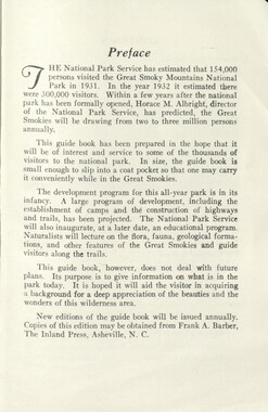
Great Smoky Mountains - A Park for America
-
Guide to the Great Smoky Mountains National Park
-
Yellow Creek Mountain

-
Handbook/ 1934/ Smoky Mountains Hiking Club

-
Mountain landscape looking into North Carolina

-
Report of the North Carolina Park Commission

-
Travel to Washington D.C.

-
Hikers at Spence Field
-
Scrapbook by A. H. McQuilkin

-
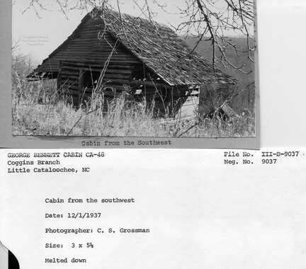
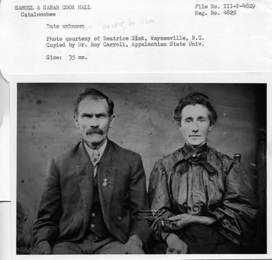
Cataloochee tract 229: M. N. Hall

-
Cataloochee tract 219: Milia Palmer

-
Cataloochee tract 232: George Bennett
-
Myron Avery, Guy Frizzell and Dutch Roth

-
Chilhowee Mountain from Scenic Loop Highway

-
Cataloochee tract 231: W. G. B. Messer
-
Cataloochee Cove Creek - Milas Messer

-
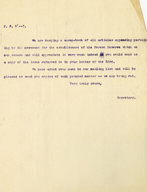
Requests for information on Appalachian National Park
-
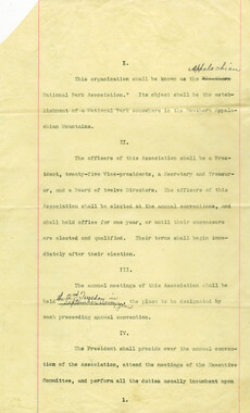
By-laws of the Appalachian National Park Association
-
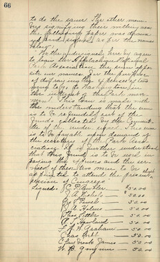
Minutes of Meetings of the Appalachian National Park Association
-
Handbook 1933 Smoky Mountains Hiking Club

-
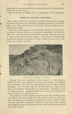
Glimpses of our National Monuments
-
Penstock at Rymers Ferry

-
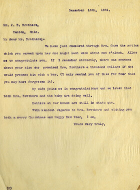
Correspondence from C. P. Ambler, December 1901
-
Senate Committee on Agriculture presentation

-
Cataloochee: cabin

-
Great Smoky Mountains National Park

-
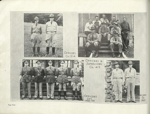
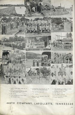
Civilian Conservation Corps Annual: District "C"
-
Appalachian National Park Association Newspaper Clippings, 1902-1907, 1925, 1928
-
Program of hikes for 1930/ Smoky Mountains Hiking Club

-
Correspondence regarding organizational meetings of the Appalachian National Park Association

-
Hikers en route to Stecoah Gap
-
Blanket Mountain
-
Correspondence between Zebulon Weaver, Fred L. Weede, W. H. Woodbury, David C. Chapman, Mark Squires, Junius G. Adams, March 1932