Western Carolina University (20)
View all
- Canton Champion Fibre Company (2308)
- Cherokee Traditions (293)
- Civil War in Southern Appalachia (165)
- Craft Revival (1942)
- Great Smoky Mountains - A Park for America (2683)
- Highlights from Western Carolina University (430)
- Horace Kephart (941)
- Journeys Through Jackson (154)
- LGBTQIA+ Archive of Jackson County (7)
- Oral Histories of Western North Carolina (314)
- Picturing Appalachia (6592)
- Stories of Mountain Folk (413)
- Travel Western North Carolina (160)
- Western Carolina University Fine Art Museum Vitreograph Collection (129)
- Western Carolina University Herbarium (92)
- Western Carolina University: Making Memories (708)
- Western Carolina University Publications (2283)
- Western Carolina University Restricted Electronic Theses and Dissertations (146)
- Western North Carolina Regional Maps (71)
- World War II in Southern Appalachia (131)
University of North Carolina Asheville (6)
View all
- Western Carolina University (2)
- Allanstand Cottage Industries (0)
- Appalachian National Park Association (0)
- Bennett, Kelly, 1890-1974 (0)
- Berry, Walter (0)
- Brasstown Carvers (0)
- Cain, Doreyl Ammons (0)
- Carver, George Washington, 1864?-1943 (0)
- Cathey, Joseph, 1803-1874 (0)
- Champion Fibre Company (0)
- Champion Paper and Fibre Company (0)
- Cherokee Indian Fair Association (0)
- Cherokee Language Program (0)
- Crittenden, Lorraine (0)
- Crowe, Amanda (0)
- Edmonston, Thomas Benton, 1842-1907 (0)
- Ensley, A. L. (Abraham Lincoln), 1865-1948 (0)
- Fromer, Irving Rhodes, 1913-1994 (0)
- George Butz (BFS 1907) (0)
- Goodrich, Frances Louisa (0)
- Grant, George Alexander, 1891-1964 (0)
- Heard, Marian Gladys (0)
- Kephart, Calvin, 1883-1969 (0)
- Kephart, Horace, 1862-1931 (0)
- Kephart, Laura, 1862-1954 (0)
- Laney, Gideon Thomas, 1889-1976 (0)
- Masa, George, 1881-1933 (0)
- McElhinney, William Julian, 1896-1953 (0)
- Niggli, Josephina, 1910-1983 (0)
- North Carolina Park Commission (0)
- Osborne, Kezia Stradley (0)
- Owens, Samuel Robert, 1918-1995 (0)
- Penland Weavers and Potters (0)
- Rhodes, Judy (0)
- Roberts, Vivienne (0)
- Roth, Albert, 1890-1974 (0)
- Schenck, Carl Alwin, 1868-1955 (0)
- Sherrill's Photography Studio (0)
- Smith, Edward Clark (0)
- Southern Highland Handicraft Guild (0)
- Southern Highlanders, Inc. (0)
- Stalcup, Jesse Bryson (0)
- Stearns, I. K. (0)
- Thompson, James Edward, 1880-1976 (0)
- United States. Indian Arts and Crafts Board (0)
- USFS (0)
- Vance, Zebulon Baird, 1830-1894 (0)
- Weaver, Zebulon, 1872-1948 (0)
- Western Carolina College (0)
- Western Carolina Teachers College (0)
- Western Carolina University. Mountain Heritage Center (0)
- Whitman, Walt, 1819-1892 (0)
- Wilburn, Hiram Coleman, 1880-1967 (0)
- Williams, Isadora (0)
- Appalachian Region, Southern (2)
- Asheville (N.C.) (2)
- Buncombe County (N.C.) (6)
- Cherokee County (N.C.) (9)
- Clay County (N.C.) (4)
- Graham County (N.C.) (6)
- Great Smoky Mountains National Park (N.C. and Tenn.) (1)
- Haywood County (N.C.) (3)
- Jackson County (N.C.) (19)
- Macon County (N.C.) (9)
- Qualla Boundary (1)
- Swain County (N.C.) (9)
- Transylvania County (N.C.) (2)
- Avery County (N.C.) (0)
- Blount County (Tenn.) (0)
- Henderson County (N.C.) (0)
- Knox County (Tenn.) (0)
- Knoxville (Tenn.) (0)
- Lake Santeetlah (N.C.) (0)
- Madison County (N.C.) (0)
- McDowell County (N.C.) (0)
- Mitchell County (N.C.) (0)
- Polk County (N.C.) (0)
- Rutherford County (N.C.) (0)
- Watauga County (N.C.) (0)
- Waynesville (N.C.) (0)
- Yancey County (N.C.) (0)
- Aerial Photographs (3)
- Aerial Views (3)
- Facsimiles (reproductions) (1)
- Maps (documents) (71)
- Albums (books) (0)
- Articles (0)
- Artifacts (object Genre) (0)
- Biography (general Genre) (0)
- Cards (information Artifacts) (0)
- Clippings (information Artifacts) (0)
- Crafts (art Genres) (0)
- Depictions (visual Works) (0)
- Design Drawings (0)
- Drawings (visual Works) (0)
- Envelopes (0)
- Fiction (general Genre) (0)
- Financial Records (0)
- Fliers (printed Matter) (0)
- Glass Plate Negatives (0)
- Guidebooks (0)
- Internegatives (0)
- Interviews (0)
- Land Surveys (0)
- Letters (correspondence) (0)
- Manuscripts (documents) (0)
- Memorandums (0)
- Minutes (administrative Records) (0)
- Negatives (photographs) (0)
- Newsletters (0)
- Newspapers (0)
- Occupation Currency (0)
- Paintings (visual Works) (0)
- Pen And Ink Drawings (0)
- Periodicals (0)
- Personal Narratives (0)
- Photographs (0)
- Poetry (0)
- Portraits (0)
- Postcards (0)
- Programs (documents) (0)
- Publications (documents) (0)
- Questionnaires (0)
- Scrapbooks (0)
- Sheet Music (0)
- Slides (photographs) (0)
- Sound Recordings (0)
- Specimens (0)
- Speeches (documents) (0)
- Text Messages (0)
- Tintypes (photographs) (0)
- Transcripts (0)
- Video Recordings (physical Artifacts) (0)
- Vitreographs (0)
- Great Smoky Mountains National Park (N.C. and Tenn.) (2)
- North Carolina -- Maps (8)
- African Americans (0)
- Appalachian Trail (0)
- Artisans (0)
- Cherokee art (0)
- Cherokee artists -- North Carolina (0)
- Cherokee language (0)
- Cherokee pottery (0)
- Cherokee women (0)
- Church buildings (0)
- Civilian Conservation Corps (U.S.) (0)
- College student newspapers and periodicals (0)
- Dams (0)
- Dance (0)
- Education (0)
- Floods (0)
- Folk music (0)
- Forced removal, 1813-1903 (0)
- Forest conservation (0)
- Forests and forestry (0)
- Gender nonconformity (0)
- Hunting (0)
- Landscape photography (0)
- Logging (0)
- Maps (0)
- Mines and mineral resources (0)
- Paper industry (0)
- Postcards (0)
- Pottery (0)
- Railroad trains (0)
- Rural electrification -- North Carolina, Western (0)
- School integration -- Southern States (0)
- Segregation -- North Carolina, Western (0)
- Slavery (0)
- Sports (0)
- Storytelling (0)
- Waterfalls -- Great Smoky Mountains (N.C. and Tenn.) (0)
- Weaving -- Appalachian Region, Southern (0)
- Wood-carving -- Appalachian Region, Southern (0)
- World War, 1939-1945 (0)
- StillImage (70)
- Text (1)
- MovingImage (0)
- Sound (0)
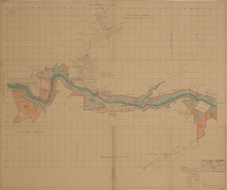
Trail of Tears
-
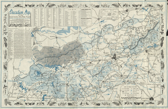
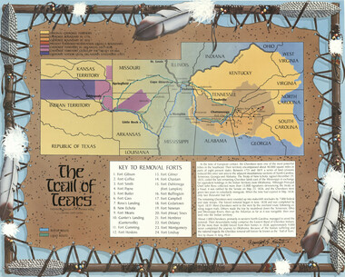
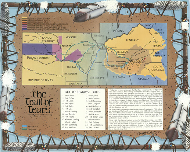
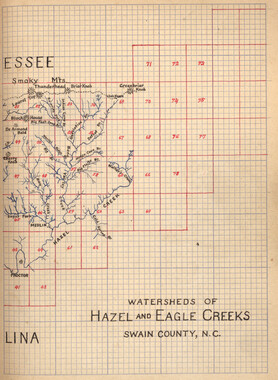
Depicts the water and land routes which were used to move the Cherokee to Oklahoma, when they were forced from their homes in the Southeast. The map also depicts the history of the Cherokee Nation from the original Cherokee Territory up to the present Qualla Boundary. Included is a brief text by Duane H. King explaining the Cherokee removal and how the name "Trail of Tears" came to be. Includes text and color illustrations.
-
-
UK _J ORIGINAL-CHEROKEE TERRITORY .7 «=JcrtEROKEE BOUNDARY IN 1776. • , _j CHEROKEE BOUNDARY IN* 1812** ==J PRESENT CHEROKEE* RESERVATION (QUALLA BOUNDARY) =JCHER0KEE TERRITORY IN ARKANSAS (I8I*>-I828) =J CHEROKEE5 TERRITORY^CEDED^BY THE'TREAJY OF 1866 I ICHEROKPE NATION UNTIL OKLAHOMA STATEHOOD (1907) KANSAS TERRITORY MISSOURI Lebanon [Springfield « JAN TERRITORY OHIO ILLINOIS INDIANA jfJ" KENTUCKY Cape \ \lonesboro Vienna WEST VIRGINIA VIRGINIA Jm Memphis ^TENNESSEE » NashviUe McMinnvIl • Savannah Chattanooga Red Clayi*"* NORTH CAROLINA Murphy Little Rock .x ARKANSAS Waterloo Tubcu REPUBLIC OF TEXAS MISSISSIPPI Bcllcfontc , ,bia —**^S Decatur ALABAMA "14 21 SOUTH N CAROLINA .17 .,8l9--20 GEORGIA LOUISIANA . • The Published^j^luseum of'tfft Cherokee Indiarj m • *. *• *. Cherokee. North Carolina Fd KEY TO REMOVAL FORTS 1. I Water* route I I L^ND ROUTE 1. Fort Gibson 2. Fort Coffee 3. Fort Smith 4. Fort Payne 5. Fort Butler 6. Fort Cass 7. Ross's Landing 8. New Echota 9. Fort Means 10. Gunter's Landing (Guntersville) 11. Fort Cumming 12. Fort Hoskins 16 Fort Gilmer Fort Chastain Fort Dahlonega (Fort Lumpkin) Fort Buffington 17. Fort Campbell 18. Fort Cedartown 19. Fort Nevvnan 20. Fort (Hinar) Sixes 21. Fort Hembree 22. Fort Delaney 23. Fort Montgomery 24. Fort Lindsay At the time of European contact, the Cherokees were one of the most powerful I tribes in the Southeast. Their territory encompassed about 40.000 square miles in parts of eight present states. Between 1721 and 1819, a series of land cessions reduced this once vast area to the adjacent mountainous sections of North Carolina. Tennessee, Georgia and Alabama. The Treaty of New Echota, signed December 29. 1835, ceded the last remaining Cherokee lands east of the Mississippi in exchange I for equivalent holdings in the Indian Territory (now Oklahoma). Although Principal Chief John Ross collected more than 15,000 signatures denouncing the treaty as a fraud, it was ratified by the Senate on May 23. 1836. and the Cherokees were I given two years to voluntarily immigrate. When the time had expired in May. 1838. I only two thousand had left. 1 The remaining Cherokees were rounded up into makeshift stockades by 7.000 federal I and state troops. The forced removal began in June, 1838 and was completed by I April, 1839. Most Cherokees went to the west by the overland route following existing wagon trails. Others made the trip by steamboat down the Tennessee. Ohio and Mississippi Rivers, then up the Arkansas as far as it was navigable, then over land into the Indian territory. About 1,000 Cherokees, primarily in western North Carolina, managed to avoid the removal. Their descendants today comprise the Eastern Band of Cherokee Indians. Of the more than 16,000 forced from their homes in 1838. approximately 4.000 never completed the journey to Oklahoma. Because of the human suffering and the national tragedy, the Cherokee removal will forever be known as the Trail of Tears." Text by Duane H. King. Ph.D. 4PJ;


Part of Collection
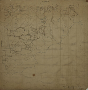
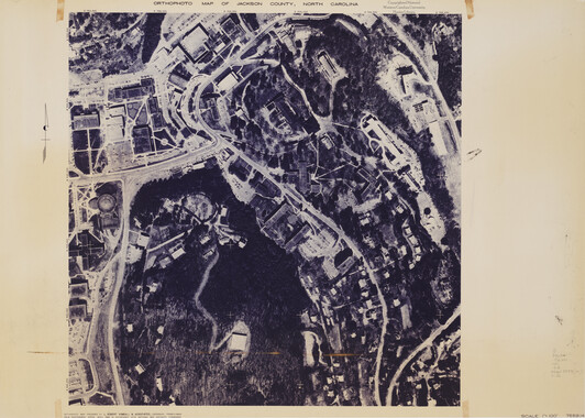
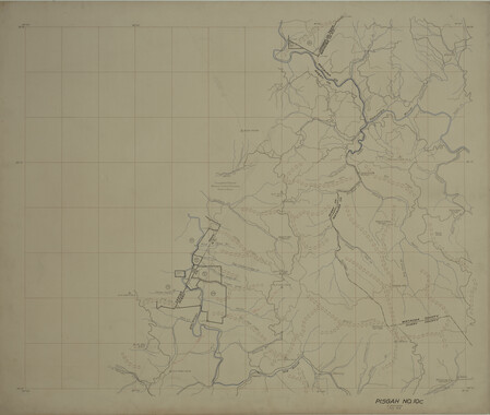
Western North Carolina Regional Maps