- Canton Champion Fibre Company (2308)
- Cherokee Traditions (293)
- Civil War in Southern Appalachia (165)
- Craft Revival (1942)
- Great Smoky Mountains - A Park for America (2683)
- Highlights from Western Carolina University (430)
- Horace Kephart (941)
- Journeys Through Jackson (154)
- LGBTQIA+ Archive of Jackson County (15)
- Oral Histories of Western North Carolina (314)
- Picturing Appalachia (6679)
- Stories of Mountain Folk (413)
- Travel Western North Carolina (160)
- Western Carolina University Fine Art Museum Vitreograph Collection (129)
- Western Carolina University Herbarium (92)
- Western Carolina University: Making Memories (708)
- Western Carolina University Publications (2283)
- Western Carolina University Restricted Electronic Theses and Dissertations (146)
- Western North Carolina Regional Maps (71)
- World War II in Southern Appalachia (131)
- Allanstand Cottage Industries (62)
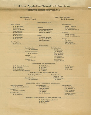
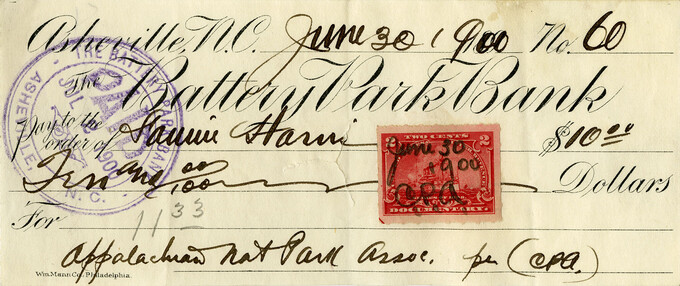
- Appalachian National Park Association (53)
- Bennett, Kelly, 1890-1974 (1295)
- Berry, Walter (76)
- Brasstown Carvers (40)
- Carver, George Washington, 1864?-1943 (26)
- Cathey, Joseph, 1803-1874 (1)
- Champion Fibre Company (233)
- Champion Paper and Fibre Company (297)
- Cherokee Indian Fair Association (16)
- Cherokee Language Program (22)
- Crowe, Amanda (40)
- Edmonston, Thomas Benton, 1842-1907 (7)
- Ensley, A. L. (Abraham Lincoln), 1865-1948 (275)
- Fromer, Irving Rhodes, 1913-1994 (70)
- George Butz (BFS 1907) (46)
- Goodrich, Frances Louisa (120)
- Grant, George Alexander, 1891-1964 (96)
- Heard, Marian Gladys (60)
- Kephart, Calvin, 1883-1969 (15)
- Kephart, Horace, 1862-1931 (313)
- Kephart, Laura, 1862-1954 (39)
- Laney, Gideon Thomas, 1889-1976 (439)
- Masa, George, 1881-1933 (61)
- McElhinney, William Julian, 1896-1953 (44)
- Niggli, Josephina, 1910-1983 (10)
- North Carolina Park Commission (105)
- Osborne, Kezia Stradley (9)
- Owens, Samuel Robert, 1918-1995 (11)
- Penland Weavers and Potters (36)
- Roberts, Vivienne (15)
- Roth, Albert, 1890-1974 (142)
- Schenck, Carl Alwin, 1868-1955 (1)
- Sherrill's Photography Studio (2565)
- Southern Highland Handicraft Guild (127)
- Southern Highlanders, Inc. (71)
- Stalcup, Jesse Bryson (46)
- Stearns, I. K. (213)
- Thompson, James Edward, 1880-1976 (226)
- United States. Indian Arts and Crafts Board (130)
- USFS (683)
- Vance, Zebulon Baird, 1830-1894 (1)
- Weaver, Zebulon, 1872-1948 (58)
- Western Carolina College (230)
- Western Carolina Teachers College (282)
- Western Carolina University (1794)
- Western Carolina University. Mountain Heritage Center (18)
- Whitman, Walt, 1819-1892 (10)
- Wilburn, Hiram Coleman, 1880-1967 (73)
- Williams, Isadora (3)
- Cain, Doreyl Ammons (0)
- Crittenden, Lorraine (0)
- Rhodes, Judy (0)
- Smith, Edward Clark (0)
- Appalachian Region, Southern (2393)
- Asheville (N.C.) (1886)
- Avery County (N.C.) (26)
- Blount County (Tenn.) (147)
- Buncombe County (N.C.) (1664)
- Cherokee County (N.C.) (283)
- Clay County (N.C.) (555)
- Graham County (N.C.) (233)
- Great Smoky Mountains National Park (N.C. and Tenn.) (478)
- Haywood County (N.C.) (3522)
- Henderson County (N.C.) (70)
- Jackson County (N.C.) (4692)
- Knox County (Tenn.) (21)
- Knoxville (Tenn.) (9)
- Lake Santeetlah (N.C.) (10)
- Macon County (N.C.) (420)
- Madison County (N.C.) (211)
- McDowell County (N.C.) (39)
- Mitchell County (N.C.) (132)
- Polk County (N.C.) (35)
- Qualla Boundary (981)
- Rutherford County (N.C.) (76)
- Swain County (N.C.) (2017)
- Transylvania County (N.C.) (247)
- Watauga County (N.C.) (12)
- Waynesville (N.C.) (68)
- Yancey County (N.C.) (72)
- Aerial Photographs (3)
- Aerial Views (60)
- Albums (books) (4)
- Articles (1)
- Artifacts (object Genre) (228)
- Biography (general Genre) (2)
- Cards (information Artifacts) (38)
- Clippings (information Artifacts) (191)
- Crafts (art Genres) (622)
- Depictions (visual Works) (21)
- Design Drawings (1)
- Drawings (visual Works) (184)
- Envelopes (73)
- Facsimiles (reproductions) (1)
- Fiction (general Genre) (4)
- Financial Records (12)
- Fliers (printed Matter) (67)
- Glass Plate Negatives (381)
- Guidebooks (2)
- Internegatives (10)
- Interviews (811)
- Land Surveys (102)
- Letters (correspondence) (1013)
- Manuscripts (documents) (619)
- Maps (documents) (159)
- Memorandums (25)
- Minutes (administrative Records) (59)
- Negatives (photographs) (5651)
- Newsletters (1285)
- Newspapers (2)
- Occupation Currency (1)
- Paintings (visual Works) (1)
- Pen And Ink Drawings (1)
- Periodicals (193)
- Personal Narratives (7)
- Photographs (12982)
- Plans (maps) (1)
- Poetry (5)
- Portraits (1654)
- Postcards (329)
- Programs (documents) (151)
- Publications (documents) (2237)
- Questionnaires (65)
- Scrapbooks (282)
- Sheet Music (1)
- Slides (photographs) (402)
- Sound Recordings (796)
- Specimens (92)
- Speeches (documents) (15)
- Tintypes (photographs) (8)
- Transcripts (322)
- Video Recordings (physical Artifacts) (23)
- Vitreographs (129)
- Text Messages (0)
- A.L. Ensley Collection (275)
- Appalachian Industrial School Records (7)
- Appalachian National Park Association Records (336)
- Axley-Meroney Collection (2)
- Bayard Wootten Photograph Collection (20)
- Bethel Rural Community Organization Collection (7)
- Blumer Collection (5)
- C.W. Slagle Collection (20)
- Canton Area Historical Museum (2110)
- Carlos C. Campbell Collection (198)
- Cataloochee History Project (65)
- Cherokee Studies Collection (4)
- Daisy Dame Photograph Album (5)
- Daniel Boone VI Collection (1)
- Doris Ulmann Photograph Collection (112)
- Elizabeth H. Lasley Collection (1)
- Elizabeth Woolworth Szold Fleharty Collection (4)
- Frank Fry Collection (95)
- George Masa Collection (173)
- Gideon Laney Collection (452)
- Hazel Scarborough Collection (2)
- Hiram C. Wilburn Papers (28)
- Historic Photographs Collection (236)
- Horace Kephart Collection (861)
- Humbard Collection (33)
- Hunter and Weaver Families Collection (1)
- I. D. Blumenthal Collection (4)
- Isadora Williams Collection (4)
- Jesse Bryson Stalcup Collection (47)
- Jim Thompson Collection (224)
- John B. Battle Collection (7)
- John C. Campbell Folk School Records (80)
- John Parris Collection (6)
- Judaculla Rock project (2)
- Kelly Bennett Collection (1314)
- Love Family Papers (11)
- Major Wiley Parris Civil War Letters (3)
- Map Collection (12)
- McFee-Misemer Civil War Letters (34)
- Mountain Heritage Center Collection (4)
- Norburn - Robertson - Thomson Families Collection (44)
- Pauline Hood Collection (7)
- Pre-Guild Collection (2)
- Qualla Arts and Crafts Mutual Collection (12)
- R.A. Romanes Collection (681)
- Rosser H. Taylor Collection (1)
- Samuel Robert Owens Collection (94)
- Sara Madison Collection (144)
- Sherrill Studio Photo Collection (2558)
- Smoky Mountains Hiking Club Collection (616)
- Stories of Mountain Folk - Radio Programs (374)
- The Reporter, Western Carolina University (510)
- Venoy and Elizabeth Reed Collection (16)
- WCU Gender and Sexuality Oral History Project (32)
- WCU Mountain Heritage Center Oral Histories (25)
- WCU Oral History Collection - Mountain People, Mountain Lives (71)
- WCU Students Newspapers Collection (1744)
- Western North Carolina Tomorrow Black Oral History Project (69)
- William Williams Stringfield Collection (2)
- Zebulon Weaver Collection (109)
- African Americans (388)
- Appalachian Trail (32)
- Artisans (521)
- Cherokee art (84)
- Cherokee artists -- North Carolina (10)
- Cherokee language (21)
- Cherokee pottery (101)
- Cherokee women (208)
- Church buildings (166)
- Civilian Conservation Corps (U.S.) (110)
- College student newspapers and periodicals (1830)
- Dams (94)
- Dance (1023)
- Education (222)
- Floods (60)
- Folk music (1015)
- Forced removal, 1813-1903 (2)
- Forest conservation (220)
- Forests and forestry (905)
- Gender nonconformity (4)
- Great Smoky Mountains National Park (N.C. and Tenn.) (154)
- Hunting (38)
- Landscape photography (10)
- Logging (103)
- Maps (84)
- Mines and mineral resources (8)
- North Carolina -- Maps (18)
- Paper industry (38)
- Postcards (255)
- Pottery (135)
- Railroad trains (69)
- Rural electrification -- North Carolina, Western (3)
- School integration -- Southern States (2)
- Segregation -- North Carolina, Western (5)
- Slavery (5)
- Sports (452)
- Storytelling (245)
- Waterfalls -- Great Smoky Mountains (N.C. and Tenn.) (66)
- Weaving -- Appalachian Region, Southern (280)
- Wood-carving -- Appalachian Region, Southern (328)
- World War, 1939-1945 (173)
Nomenclature notes: suggested changes to place names


Nomenclature notes: suggested changes to place names
GSMNP_13150_06_01_1001_01
Nomenclature notes: suggested changes to place names
GSMNP_13150_06_01_1001_02_a
Nomenclature notes: suggested changes to place names
GSMNP_13150_06_01_1001_02_b
Nomenclature notes: suggested changes to place names
GSMNP_13150_06_01_1001_03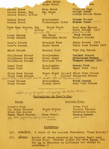
Nomenclature notes: suggested changes to place names
GSMNP_13150_06_01_1001_04
Nomenclature notes: suggested changes to place names
GSMNP_13150_06_01_1001_05
Nomenclature notes: suggested changes to place names
GSMNP_13150_06_01_1001_06
Nomenclature notes: suggested changes to place names
GSMNP_13150_06_01_1001_07
Nomenclature notes: suggested changes to place names
GSMNP_13150_06_01_1001_08
Nomenclature notes: suggested changes to place names
GSMNP_13150_06_02_1090_01_a
Nomenclature notes: suggested changes to place names
GSMNP_13150_06_02_1090_01_b
Nomenclature notes: suggested changes to place names
GSMNP_13150_06_02_1090_02_a
Nomenclature notes: suggested changes to place names
GSMNP_13150_06_02_1090_02_b
Nomenclature notes: suggested changes to place names
GSMNP_13150_06_02_1090_03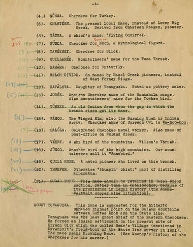
Nomenclature notes: suggested changes to place names
GSMNP_13150_06_02_1090_04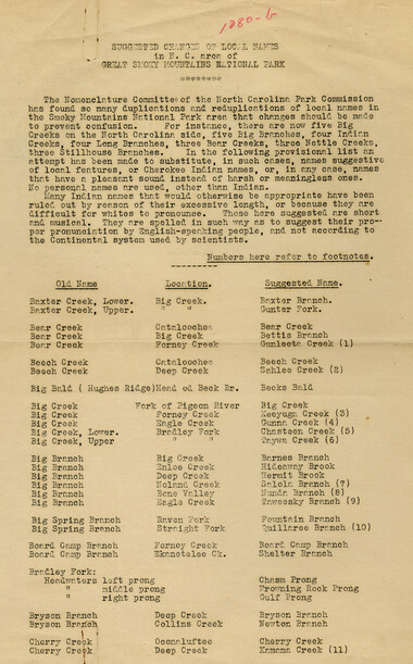
Nomenclature notes: suggested changes to place names
GSMNP_13150_06_03_1080_b_01
Nomenclature notes: suggested changes to place names
GSMNP_13150_06_03_1080_b_02
Nomenclature notes: suggested changes to place names
GSMNP_13150_06_03_1080_b_03
Nomenclature notes: suggested changes to place names
GSMNP_13150_06_04_1040_a_01
Nomenclature notes: suggested changes to place names
GSMNP_13150_06_04_1040_a_02
Nomenclature notes: suggested changes to place names
GSMNP_13150_06_04_1040_a_03
Nomenclature notes: suggested changes to place names
GSMNP_13150_06_04_1040_a_04Item’s are ‘child’ level descriptions to ‘parent’ objects, (e.g. one page of a whole book).
-
-
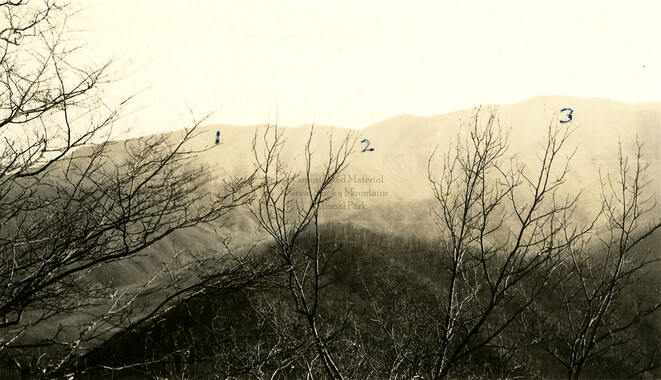
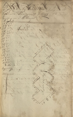
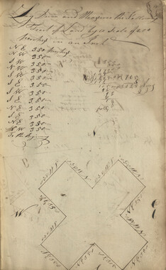
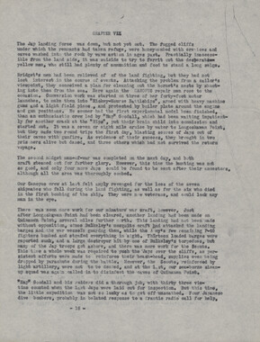
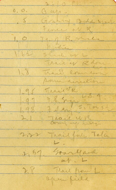
V 1 - FORGE HOI| Elevetion I see 110*18 ~ 7. i 2 * Brier Lick Knob; Elevation ! Determine how to re?-d contour Ixik . I me Powell Knob. > 3 - I0QK GAP; should be locates between Brie Lick Gap am! Doe Knub^ 18 - 8. 4 * FORCE KNOB, BRIER 1,1CI gXR$ KR0>j ft)* KNOB and PG*7EIJL KNOB; Sft or old names ! 5 - Bead vatere of Ekaneetlee Creek; Thomas Cove Br.t Big Tommy Br. u.ad Little Toiaray 3r. locations confusing* ), 8 - Red Ridge Br. and find Ridg© Gap; too much aparted* 1 - 1*0 0,-PS; between Russell Field and Little Baidf HcCampbeile and Maple Sugar Gape - 18-6* 19-4, * Maple Lugar Cap ie locates the base -of Ruaeell Fi#l< and there is no gap farther Mtt between Little Bald, 8 - Location of LITTLE BALD; Zm 19-7, 9 - Location of HALL CASH ! Map shows this Gap too close to Sugar Tree Gap* If I am not mistakent it locates between Little MM|X Chestnut Bald(read of Chestnut Ridg©) and Big Chestnut B&ld{uead of Locust Ridge; in the map shows Derrick jfaob») 10 * OOF Iff Southern sloped and of Mt# Sequoyah; hovj gat the name? 11 - INADU ..B, ftUHtti HmT KMHB, Mftt '" MR, COSBY KNOB and SUNUP KNOB; >'.&:. or old names ? 12 - DLLH GHBEK GAP; a short distance from Old Black toward N*t* Se# 14-3* Dear Creek Gap should ©how on mxpf elevation 6»020 highest Gap in 5imkim.
Object’s are ‘parent’ level descriptions to ‘children’ items, (e.g. a book with pages).
-
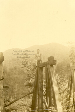
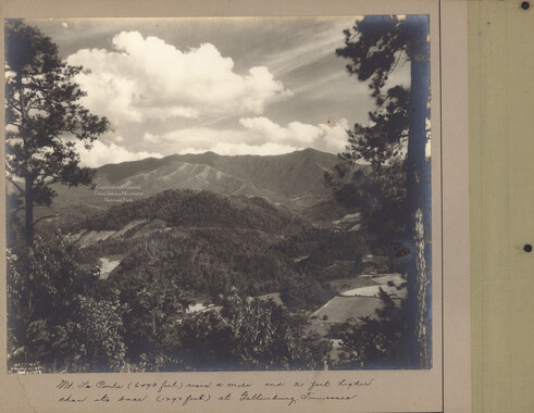
Like many rural areas, names of places within the Great Smoky Mountains were sometimes redundant or known by different names in different localities. In the 1930s, the National Park Service appointed a Nomenclature Committee from North Carolina and one from Tennessee to decide upon “official” names for peaks, creeks, and roads. Photographer and park advocate, George Masa served on the North Carolina committee. Born Masahara Iizuka and raised in Japan, George Masa (1881-1933) emigrated to the U.S. when he was 20 years old and, in 1915, came to Asheville, where he lived the rest of his life. Masa was active in the Appalachian Trail Club and in the movement to establish the Great Smoky Mountains National Park.
-


Part of Collection
Great Smoky Mountains - A Park for America