- Canton Champion Fibre Company (127)
- Cherokee Traditions (3)
- Craft Revival (326)
- Great Smoky Mountains - A Park for America (461)
- Highlights from Western Carolina University (37)
- Horace Kephart (219)
- Oral Histories of Western North Carolina (2)
- Picturing Appalachia (1310)
- Travel Western North Carolina (39)
- Western Carolina University: Making Memories (63)
- Western Carolina University Publications (57)
- World War II in Southern Appalachia (1)
- Civil War in Southern Appalachia (0)
- Journeys Through Jackson (0)
- LGBTQIA+ Archive of Jackson County (0)
- Stories of Mountain Folk (0)
- Western Carolina University Fine Art Museum Vitreograph Collection (0)
- Western Carolina University Herbarium (0)
- Western Carolina University Restricted Electronic Theses and Dissertations (0)
- Western North Carolina Regional Maps (0)
- Forestry in Western North Carolina (3)
- Picturing Asheville and Western North Carolina (1)
- Faces of Asheville (0)
- Grove Park Inn Photograph Collection (0)
- Isaiah Rice Photograph Collection (0)
- Morse Family Chimney Rock Park Collection (0)
- Allanstand Cottage Industries (25)
- Appalachian National Park Association (1)
- Bennett, Kelly, 1890-1974 (623)
- Carver, George Washington, 1864?-1943 (23)
- Champion Fibre Company (85)
- Cherokee Indian Fair Association (1)
- Goodrich, Frances Louisa (58)
- Kephart, Calvin, 1883-1969 (15)
- Kephart, Horace, 1862-1931 (58)
- Kephart, Laura, 1862-1954 (2)
- Laney, Gideon Thomas, 1889-1976 (431)
- Masa, George, 1881-1933 (35)
- McElhinney, William Julian, 1896-1953 (17)
- North Carolina Park Commission (100)
- Penland Weavers and Potters (3)
- Roth, Albert, 1890-1974 (7)
- Sherrill's Photography Studio (21)
- Southern Highland Handicraft Guild (1)
- Stalcup, Jesse Bryson (39)
- Stearns, I. K. (1)
- Thompson, James Edward, 1880-1976 (122)
- USFS (1)
- Weaver, Zebulon, 1872-1948 (8)
- Western Carolina Teachers College (7)
- Wilburn, Hiram Coleman, 1880-1967 (55)
- Berry, Walter (0)
- Brasstown Carvers (0)
- Cain, Doreyl Ammons (0)
- Cathey, Joseph, 1803-1874 (0)
- Champion Paper and Fibre Company (0)
- Cherokee Language Program (0)
- Crittenden, Lorraine (0)
- Crowe, Amanda (0)
- Edmonston, Thomas Benton, 1842-1907 (0)
- Ensley, A. L. (Abraham Lincoln), 1865-1948 (0)
- Fromer, Irving Rhodes, 1913-1994 (0)
- George Butz (BFS 1907) (0)
- Grant, George Alexander, 1891-1964 (0)
- Heard, Marian Gladys (0)
- Niggli, Josephina, 1910-1983 (0)
- Osborne, Kezia Stradley (0)
- Owens, Samuel Robert, 1918-1995 (0)
- Rhodes, Judy (0)
- Roberts, Vivienne (0)
- Schenck, Carl Alwin, 1868-1955 (0)
- Smith, Edward Clark (0)
- Southern Highlanders, Inc. (0)
- United States. Indian Arts and Crafts Board (0)
- Vance, Zebulon Baird, 1830-1894 (0)
- Western Carolina College (0)
- Western Carolina University (0)
- Western Carolina University. Mountain Heritage Center (0)
- Whitman, Walt, 1819-1892 (0)
- Williams, Isadora (0)
- Appalachian Region, Southern (303)
- Asheville (N.C.) (5)
- Avery County (N.C.) (4)
- Blount County (Tenn.) (25)
- Buncombe County (N.C.) (123)
- Cherokee County (N.C.) (37)
- Clay County (N.C.) (443)
- Graham County (N.C.) (16)
- Great Smoky Mountains National Park (N.C. and Tenn.) (28)
- Haywood County (N.C.) (264)
- Henderson County (N.C.) (1)
- Jackson County (N.C.) (190)
- Knox County (Tenn.) (2)
- Knoxville (Tenn.) (1)
- Lake Santeetlah (N.C.) (1)
- Macon County (N.C.) (67)
- Madison County (N.C.) (16)
- McDowell County (N.C.) (7)
- Mitchell County (N.C.) (32)
- Polk County (N.C.) (7)
- Qualla Boundary (30)
- Rutherford County (N.C.) (4)
- Swain County (N.C.) (676)
- Transylvania County (N.C.) (1)
- Watauga County (N.C.) (2)
- Waynesville (N.C.) (3)
- Yancey County (N.C.) (22)
- Aerial Views (9)
- Albums (books) (1)
- Articles (1)
- Artifacts (object Genre) (87)
- Cards (information Artifacts) (2)
- Clippings (information Artifacts) (30)
- Crafts (art Genres) (70)
- Envelopes (21)
- Financial Records (2)
- Glass Plate Negatives (3)
- Interviews (2)
- Land Surveys (95)
- Letters (correspondence) (219)
- Manuscripts (documents) (96)
- Maps (documents) (37)
- Memorandums (1)
- Minutes (administrative Records) (4)
- Negatives (photographs) (947)
- Newsletters (97)
- Paintings (visual Works) (1)
- Photographs (869)
- Portraits (324)
- Postcards (26)
- Programs (documents) (19)
- Publications (documents) (167)
- Scrapbooks (2)
- Slides (photographs) (6)
- Sound Recordings (4)
- Speeches (documents) (3)
- Transcripts (6)
- Aerial Photographs (0)
- Biography (general Genre) (0)
- Depictions (visual Works) (0)
- Design Drawings (0)
- Drawings (visual Works) (0)
- Facsimiles (reproductions) (0)
- Fiction (general Genre) (0)
- Fliers (printed Matter) (0)
- Guidebooks (0)
- Internegatives (0)
- Newspapers (0)
- Occupation Currency (0)
- Pen And Ink Drawings (0)
- Periodicals (0)
- Personal Narratives (0)
- Plans (maps) (0)
- Poetry (0)
- Questionnaires (0)
- Sheet Music (0)
- Specimens (0)
- Text Messages (0)
- Tintypes (photographs) (0)
- Video Recordings (physical Artifacts) (0)
- Vitreographs (0)
- Appalachian Industrial School Records (2)
- Appalachian National Park Association Records (26)
- Axley-Meroney Collection (1)
- Bayard Wootten Photograph Collection (8)
- Bethel Rural Community Organization Collection (1)
- Canton Area Historical Museum (97)
- Cataloochee History Project (41)
- Daisy Dame Photograph Album (4)
- Doris Ulmann Photograph Collection (3)
- George Masa Collection (96)
- Gideon Laney Collection (443)
- Hazel Scarborough Collection (1)
- Historic Photographs Collection (29)
- Horace Kephart Collection (253)
- Jesse Bryson Stalcup Collection (39)
- Jim Thompson Collection (121)
- John B. Battle Collection (2)
- John C. Campbell Folk School Records (13)
- John Parris Collection (1)
- Kelly Bennett Collection (631)
- Love Family Papers (2)
- Map Collection (4)
- Norburn - Robertson - Thomson Families Collection (1)
- Pre-Guild Collection (1)
- R.A. Romanes Collection (5)
- Samuel Robert Owens Collection (1)
- Sara Madison Collection (4)
- Sherrill Studio Photo Collection (21)
- Smoky Mountains Hiking Club Collection (78)
- WCU Students Newspapers Collection (57)
- Zebulon Weaver Collection (12)
- A.L. Ensley Collection (0)
- Blumer Collection (0)
- C.W. Slagle Collection (0)
- Carlos C. Campbell Collection (0)
- Cherokee Studies Collection (0)
- Daniel Boone VI Collection (0)
- Elizabeth H. Lasley Collection (0)
- Elizabeth Woolworth Szold Fleharty Collection (0)
- Frank Fry Collection (0)
- Hiram C. Wilburn Papers (0)
- Humbard Collection (0)
- Hunter and Weaver Families Collection (0)
- I. D. Blumenthal Collection (0)
- Isadora Williams Collection (0)
- Judaculla Rock project (0)
- Major Wiley Parris Civil War Letters (0)
- McFee-Misemer Civil War Letters (0)
- Mountain Heritage Center Collection (0)
- Pauline Hood Collection (0)
- Qualla Arts and Crafts Mutual Collection (0)
- Rosser H. Taylor Collection (0)
- Stories of Mountain Folk - Radio Programs (0)
- The Reporter, Western Carolina University (0)
- Venoy and Elizabeth Reed Collection (0)
- WCU Gender and Sexuality Oral History Project (0)
- WCU Mountain Heritage Center Oral Histories (0)
- WCU Oral History Collection - Mountain People, Mountain Lives (0)
- Western North Carolina Tomorrow Black Oral History Project (0)
- William Williams Stringfield Collection (0)
- African Americans (15)
- Appalachian Trail (3)
- Artisans (30)
- Cherokee pottery (1)
- Cherokee women (1)
- Church buildings (21)
- College student newspapers and periodicals (57)
- Dams (24)
- Education (13)
- Floods (3)
- Forest conservation (6)
- Forests and forestry (11)
- Great Smoky Mountains National Park (N.C. and Tenn.) (26)
- Hunting (3)
- Logging (2)
- Maps (29)
- Mines and mineral resources (2)
- North Carolina -- Maps (4)
- Paper industry (3)
- Postcards (5)
- Pottery (10)
- Railroad trains (9)
- Sports (12)
- Storytelling (1)
- Waterfalls -- Great Smoky Mountains (N.C. and Tenn.) (21)
- Weaving -- Appalachian Region, Southern (100)
- Wood-carving -- Appalachian Region, Southern (6)
- World War, 1939-1945 (1)
- Cherokee art (0)
- Cherokee artists -- North Carolina (0)
- Cherokee language (0)
- Civilian Conservation Corps (U.S.) (0)
- Dance (0)
- Folk music (0)
- Forced removal, 1813-1903 (0)
- Gender nonconformity (0)
- Landscape photography (0)
- Rural electrification -- North Carolina, Western (0)
- School integration -- Southern States (0)
- Segregation -- North Carolina, Western (0)
- Slavery (0)
- Sound (4)
- StillImage (2034)
- Text (675)
- MovingImage (0)
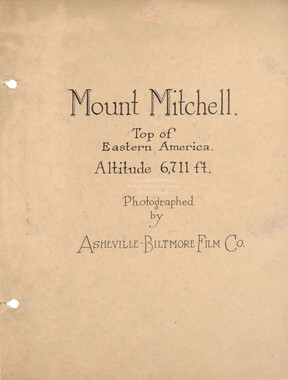
Mount Mitchell and views ~ along Mt. Mitchell Motor Road, front cover
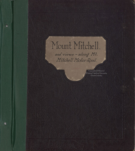

Mount Mitchell and views ~ along Mt. Mitchell Motor Road, front cover
HL_MSS80_29_13_00_a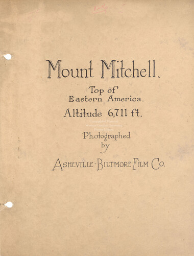
Mount Mitchell and views ~ along Mt. Mitchell Motor Road, page 1
HL_MSS80_29_13_00_b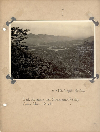
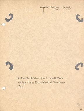
Mount Mitchell and views ~ along Mt. Mitchell Motor Road, page 2
HL_MSS80_29_13_01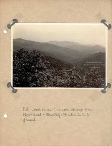
Mount Mitchell and views ~ along Mt. Mitchell Motor Road, page 3
HL_MSS80_29_13_02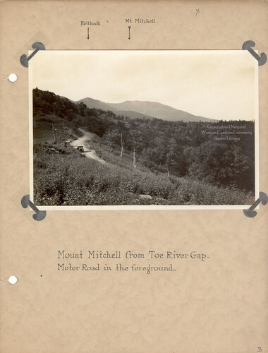
Mount Mitchell and views ~ along Mt. Mitchell Motor Road, page 4
HL_MSS80_29_13_03
Mount Mitchell and views ~ along Mt. Mitchell Motor Road, page 5
HL_MSS80_29_13_04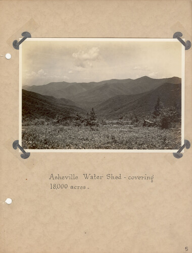
Mount Mitchell and views ~ along Mt. Mitchell Motor Road, page 6
HL_MSS80_29_13_05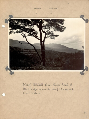
Mount Mitchell and views ~ along Mt. Mitchell Motor Road, page 7
HL_MSS80_29_13_06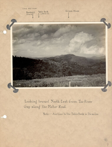
Mount Mitchell and views ~ along Mt. Mitchell Motor Road, page 8
HL_MSS80_29_13_07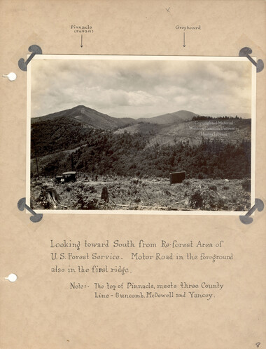
Mount Mitchell and views ~ along Mt. Mitchell Motor Road, page 9
HL_MSS80_29_13_08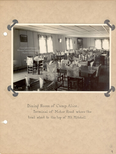
Mount Mitchell and views ~ along Mt. Mitchell Motor Road, page 10
HL_MSS80_29_13_09
Mount Mitchell and views ~ along Mt. Mitchell Motor Road, page 11
HL_MSS80_29_13_10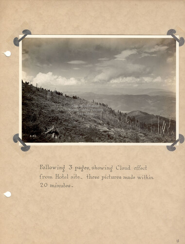
Mount Mitchell and views ~ along Mt. Mitchell Motor Road, page 12
HL_MSS80_29_13_11
Mount Mitchell and views ~ along Mt. Mitchell Motor Road, page 13
HL_MSS80_29_13_12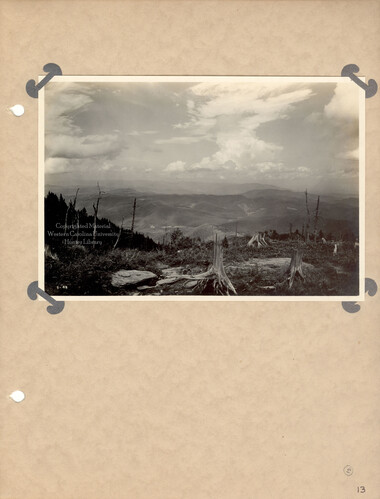
Mount Mitchell and views ~ along Mt. Mitchell Motor Road, page 14
HL_MSS80_29_13_13
Mount Mitchell and views ~ along Mt. Mitchell Motor Road, page 15
HL_MSS80_29_13_14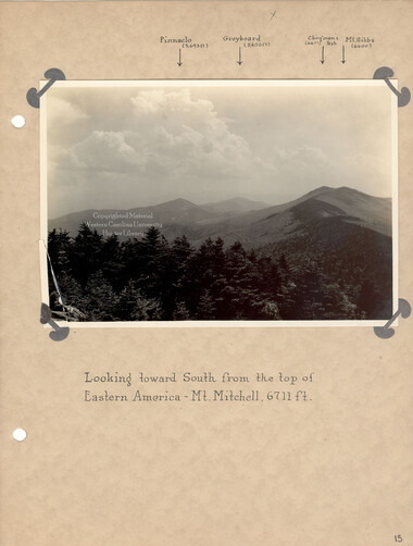
Mount Mitchell and views ~ along Mt. Mitchell Motor Road, page 16
HL_MSS80_29_13_15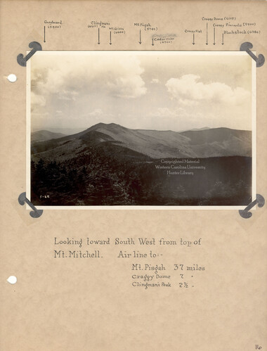
Mount Mitchell and views ~ along Mt. Mitchell Motor Road, page 17
HL_MSS80_29_13_16
Mount Mitchell and views ~ along Mt. Mitchell Motor Road, page 18
HL_MSS80_29_13_17
Mount Mitchell and views ~ along Mt. Mitchell Motor Road, page 19
HL_MSS80_29_13_18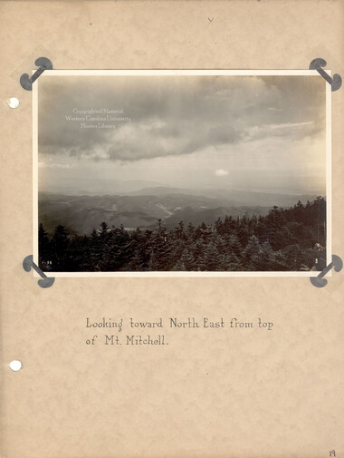
Mount Mitchell and views ~ along Mt. Mitchell Motor Road, page 20
HL_MSS80_29_13_19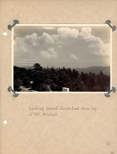
Mount Mitchell and views ~ along Mt. Mitchell Motor Road, page 21
HL_MSS80_29_13_20
Mount Mitchell and views ~ along Mt. Mitchell Motor Road, page 22
HL_MSS80_29_13_21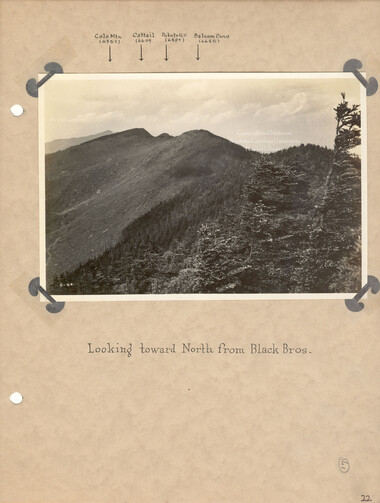
Mount Mitchell and views ~ along Mt. Mitchell Motor Road, page 23
HL_MSS80_29_13_22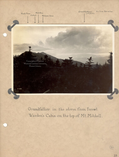
Mount Mitchell and views ~ along Mt. Mitchell Motor Road, page 24
HL_MSS80_29_13_23
Mount Mitchell and views ~ along Mt. Mitchell Motor Road, page 25
HL_MSS80_29_13_24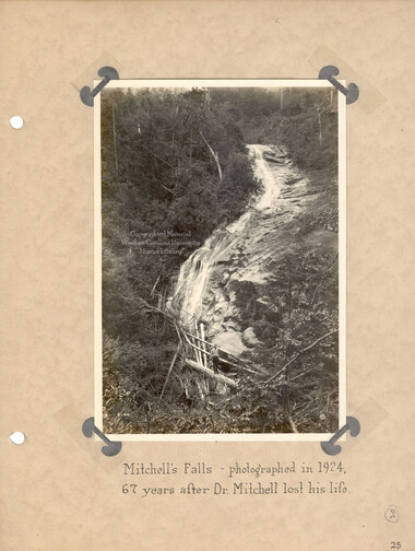
Mount Mitchell and views ~ along Mt. Mitchell Motor Road, page 26
HL_MSS80_29_13_25
Mount Mitchell and views ~ along Mt. Mitchell Motor Road, page 27
HL_MSS80_29_13_26
Mount Mitchell and views ~ along Mt. Mitchell Motor Road, back cover
HL_MSS80_29_13_27Item’s are ‘child’ level descriptions to ‘parent’ objects, (e.g. one page of a whole book).
Object’s are ‘parent’ level descriptions to ‘children’ items, (e.g. a book with pages).
-
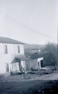
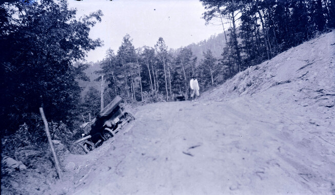
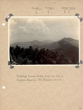
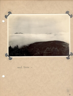
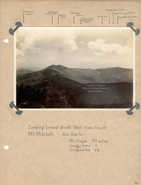
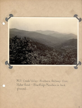
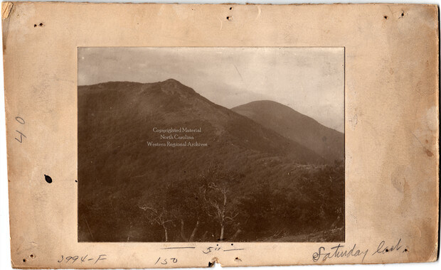
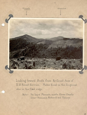
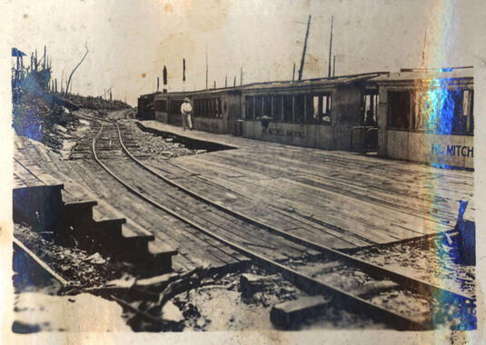
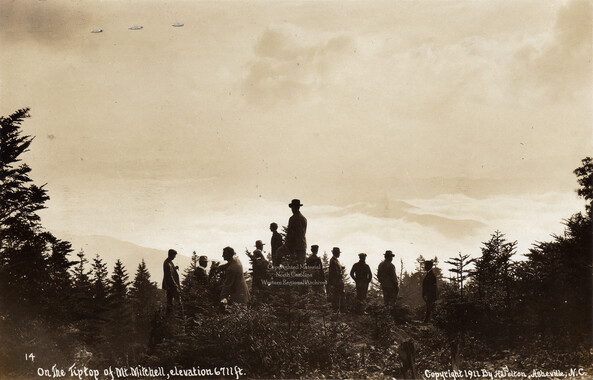
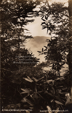
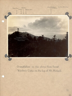
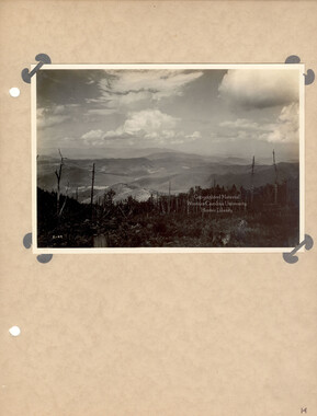
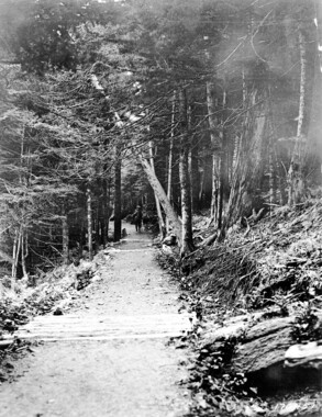
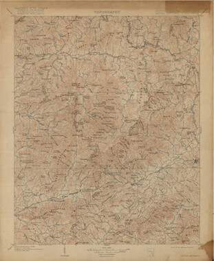
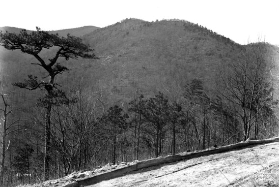
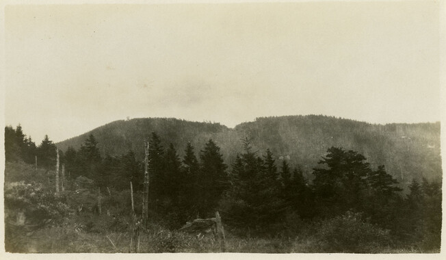
The Mount Mitchell Motor Road was built over an existing route that went up Mt. Mitchell. Originally constructed as a logging rail line around the turn of the century, in 1921, the railroad track was replaced by an automobile toll road. The “motor road” ran from the town of Black Mountain to Camp Alice near the summit of Mt. Mitchell. About 1924, photographer George Masa (1881-1933) took a series of photographs along the road and organized them into a 27-page photo album that included annotations that indicated prominent features along the route. The leather-bound album cover is labeled, “Mount Mitchell and views ~ along Mt. Mitchell Motor Road;” the interior title page reads, “Mount Mitchell. Top of Eastern America. Altitude 6,711 ft.” Mt. Mitchell is located in Yancey County, North Carolina and is the highest peak east of the Mississippi River.
-


Part of Collection
Picturing Appalachia