- Canton Champion Fibre Company (2308)
- Cherokee Traditions (293)
- Civil War in Southern Appalachia (165)
- Craft Revival (1942)
- Great Smoky Mountains - A Park for America (2767)
- Highlights from Western Carolina University (430)
- Horace Kephart (941)
- Journeys Through Jackson (154)
- LGBTQIA+ Archive of Jackson County (19)
- Oral Histories of Western North Carolina (314)
- Picturing Appalachia (6679)
- Stories of Mountain Folk (413)
- Travel Western North Carolina (160)
- Western Carolina University Fine Art Museum Vitreograph Collection (129)
- Western Carolina University Herbarium (92)
- Western Carolina University: Making Memories (708)
- Western Carolina University Publications (2283)
- Western Carolina University Restricted Electronic Theses and Dissertations (146)
- Western North Carolina Regional Maps (71)
- World War II in Southern Appalachia (131)
- Appalachian National Park Association (53)
- Berry, Walter (76)
- Champion Fibre Company (5)
- Fromer, Irving Rhodes, 1913-1994 (70)
- Grant, George Alexander, 1891-1964 (96)
- Kephart, Horace, 1862-1931 (23)
- Masa, George, 1881-1933 (17)
- North Carolina Park Commission (105)
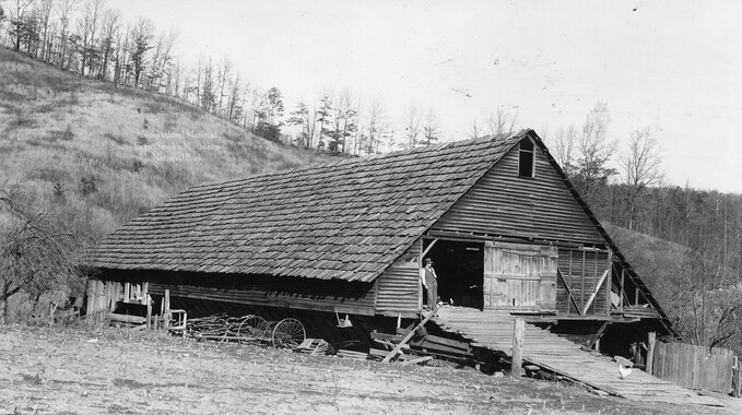
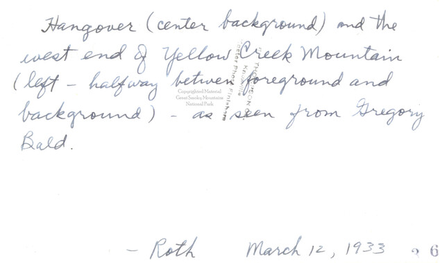
- Roth, Albert, 1890-1974 (142)
- Schenck, Carl Alwin, 1868-1955 (1)
- Stearns, I. K. (2)
- Thompson, James Edward, 1880-1976 (45)
- Weaver, Zebulon, 1872-1948 (55)
- Wilburn, Hiram Coleman, 1880-1967 (72)
- Allanstand Cottage Industries (0)
- Bennett, Kelly, 1890-1974 (0)
- Brasstown Carvers (0)
- Cain, Doreyl Ammons (0)
- Carver, George Washington, 1864?-1943 (0)
- Cathey, Joseph, 1803-1874 (0)
- Champion Paper and Fibre Company (0)
- Cherokee Indian Fair Association (0)
- Cherokee Language Program (0)
- Crittenden, Lorraine (0)
- Crowe, Amanda (0)
- Edmonston, Thomas Benton, 1842-1907 (0)
- Ensley, A. L. (Abraham Lincoln), 1865-1948 (0)
- George Butz (BFS 1907) (0)
- Goodrich, Frances Louisa (0)
- Heard, Marian Gladys (0)
- Kephart, Calvin, 1883-1969 (0)
- Kephart, Laura, 1862-1954 (0)
- Laney, Gideon Thomas, 1889-1976 (0)
- McElhinney, William Julian, 1896-1953 (0)
- Niggli, Josephina, 1910-1983 (0)
- Osborne, Kezia Stradley (0)
- Owens, Samuel Robert, 1918-1995 (0)
- Penland Weavers and Potters (0)
- Rhodes, Judy (0)
- Roberts, Vivienne (0)
- Sherrill's Photography Studio (0)
- Smith, Edward Clark (0)
- Southern Highland Handicraft Guild (0)
- Southern Highlanders, Inc. (0)
- Stalcup, Jesse Bryson (0)
- United States. Indian Arts and Crafts Board (0)
- USFS (0)
- Vance, Zebulon Baird, 1830-1894 (0)
- Western Carolina College (0)
- Western Carolina Teachers College (0)
- Western Carolina University (0)
- Western Carolina University. Mountain Heritage Center (0)
- Whitman, Walt, 1819-1892 (0)
- Williams, Isadora (0)
- 1810s (1)
- 1840s (1)
- 1850s (2)
- 1860s (3)
- 1870s (4)
- 1880s (7)
- 1890s (64)
- 1900s (294)
- 1910s (227)
- 1920s (461)
- 1930s (1585)
- 1940s (82)
- 1950s (15)
- 1960s (13)
- 1970s (47)
- 1980s (14)
- 1990s (17)
- 2000s (31)
- 2010s (1)
- 1600s (0)
- 1700s (0)
- 1800s (0)
- 1820s (0)
- 1830s (0)
- 2020s (0)
- Appalachian Region, Southern (80)
- Asheville (N.C.) (1)
- Avery County (N.C.) (6)
- Blount County (Tenn.) (159)
- Buncombe County (N.C.) (204)
- Cherokee County (N.C.) (10)
- Clay County (N.C.) (3)
- Graham County (N.C.) (108)
- Great Smoky Mountains National Park (N.C. and Tenn.) (416)
- Haywood County (N.C.) (263)
- Henderson County (N.C.) (13)
- Jackson County (N.C.) (58)
- Knox County (Tenn.) (21)
- Knoxville (Tenn.) (11)
- Lake Santeetlah (N.C.) (10)
- Macon County (N.C.) (25)
- Madison County (N.C.) (14)
- McDowell County (N.C.) (5)
- Mitchell County (N.C.) (7)
- Polk County (N.C.) (2)
- Qualla Boundary (22)
- Rutherford County (N.C.) (16)
- Swain County (N.C.) (516)
- Transylvania County (N.C.) (36)
- Watauga County (N.C.) (2)
- Waynesville (N.C.) (2)
- Yancey County (N.C.) (34)
- Aerial Views (3)
- Articles (1)
- Artifacts (object Genre) (4)
- Clippings (information Artifacts) (77)
- Drawings (visual Works) (174)
- Envelopes (2)
- Financial Records (9)
- Fliers (printed Matter) (34)
- Guidebooks (1)
- Interviews (11)
- Land Surveys (102)
- Letters (correspondence) (219)
- Manuscripts (documents) (91)
- Maps (documents) (69)
- Memorandums (14)
- Minutes (administrative Records) (20)
- Negatives (photographs) (282)
- Newsletters (12)
- Paintings (visual Works) (1)
- Pen And Ink Drawings (1)
- Photographs (1657)
- Portraits (39)
- Postcards (15)
- Publications (documents) (107)
- Scrapbooks (3)
- Sound Recordings (7)
- Speeches (documents) (11)
- Transcripts (46)
- Aerial Photographs (0)
- Albums (books) (0)
- Biography (general Genre) (0)
- Cards (information Artifacts) (0)
- Crafts (art Genres) (0)
- Depictions (visual Works) (0)
- Design Drawings (0)
- Facsimiles (reproductions) (0)
- Fiction (general Genre) (0)
- Glass Plate Negatives (0)
- Internegatives (0)
- Newspapers (0)
- Occupation Currency (0)
- Periodicals (0)
- Personal Narratives (0)
- Plans (maps) (0)
- Poetry (0)
- Programs (documents) (0)
- Questionnaires (0)
- Sheet Music (0)
- Slides (photographs) (0)
- Specimens (0)
- Text Messages (0)
- Tintypes (photographs) (0)
- Video Recordings (physical Artifacts) (0)
- Vitreographs (0)
- Appalachian National Park Association Records (336)
- Carlos C. Campbell Collection (282)
- Cataloochee History Project (65)
- George Masa Collection (89)
- Hiram C. Wilburn Papers (28)
- Historic Photographs Collection (236)
- Horace Kephart Collection (126)
- Humbard Collection (33)
- Jim Thompson Collection (44)
- Love Family Papers (11)
- Map Collection (12)
- R.A. Romanes Collection (10)
- Smoky Mountains Hiking Club Collection (616)
- Zebulon Weaver Collection (107)
- A.L. Ensley Collection (0)
- Appalachian Industrial School Records (0)
- Axley-Meroney Collection (0)
- Bayard Wootten Photograph Collection (0)
- Bethel Rural Community Organization Collection (0)
- Blumer Collection (0)
- C.W. Slagle Collection (0)
- Canton Area Historical Museum (0)
- Cherokee Studies Collection (0)
- Daisy Dame Photograph Album (0)
- Daniel Boone VI Collection (0)
- Doris Ulmann Photograph Collection (0)
- Elizabeth H. Lasley Collection (0)
- Elizabeth Woolworth Szold Fleharty Collection (0)
- Frank Fry Collection (0)
- Gideon Laney Collection (0)
- Hazel Scarborough Collection (0)
- Hunter and Weaver Families Collection (0)
- I. D. Blumenthal Collection (0)
- Isadora Williams Collection (0)
- Jesse Bryson Stalcup Collection (0)
- John B. Battle Collection (0)
- John C. Campbell Folk School Records (0)
- John Parris Collection (0)
- Judaculla Rock project (0)
- Kelly Bennett Collection (0)
- Major Wiley Parris Civil War Letters (0)
- McFee-Misemer Civil War Letters (0)
- Mountain Heritage Center Collection (0)
- Norburn - Robertson - Thomson Families Collection (0)
- Pauline Hood Collection (0)
- Pre-Guild Collection (0)
- Qualla Arts and Crafts Mutual Collection (0)
- Rosser H. Taylor Collection (0)
- Samuel Robert Owens Collection (0)
- Sara Madison Collection (0)
- Sherrill Studio Photo Collection (0)
- Stories of Mountain Folk - Radio Programs (0)
- The Reporter, Western Carolina University (0)
- Venoy and Elizabeth Reed Collection (0)
- WCU Gender and Sexuality Oral History Project (0)
- WCU Mountain Heritage Center Oral Histories (0)
- WCU Oral History Collection - Mountain People, Mountain Lives (0)
- WCU Students Newspapers Collection (0)
- Western North Carolina Tomorrow Black Oral History Project (0)
- William Williams Stringfield Collection (0)
- Appalachian Trail (22)
- Church buildings (9)
- Civilian Conservation Corps (U.S.) (91)
- Dams (21)
- Floods (1)
- Forest conservation (11)
- Forests and forestry (42)
- Great Smoky Mountains National Park (N.C. and Tenn.) (64)
- Hunting (2)
- Logging (25)
- Maps (74)
- North Carolina -- Maps (5)
- Postcards (15)
- Railroad trains (8)
- Sports (4)
- Storytelling (2)
- Waterfalls -- Great Smoky Mountains (N.C. and Tenn.) (39)
- African Americans (0)
- Artisans (0)
- Cherokee art (0)
- Cherokee artists -- North Carolina (0)
- Cherokee language (0)
- Cherokee pottery (0)
- Cherokee women (0)
- College student newspapers and periodicals (0)
- Dance (0)
- Education (0)
- Folk music (0)
- Forced removal, 1813-1903 (0)
- Gender nonconformity (0)
- Landscape photography (0)
- Mines and mineral resources (0)
- Paper industry (0)
- Pottery (0)
- Rural electrification -- North Carolina, Western (0)
- School integration -- Southern States (0)
- Segregation -- North Carolina, Western (0)
- Slavery (0)
- Weaving -- Appalachian Region, Southern (0)
- Wood-carving -- Appalachian Region, Southern (0)
- World War, 1939-1945 (0)
- Sound (7)
- StillImage (2172)
- Text (655)
- MovingImage (0)
Federal court records: Stevenson et al. v. Fain et al.: Telico River area

Federal court records: Stevenson et al. v. Fain et al.: Telico River area
GSMNP_13150_16_1133_01
Federal court records: Stevenson et al. v. Fain et al.: Telico River area
GSMNP_13150_16_1133_02
Federal court records: Stevenson et al. v. Fain et al.: Telico River area
GSMNP_13150_16_1133_03
Federal court records: Stevenson et al. v. Fain et al.: Telico River area
GSMNP_13150_16_1133_04
Federal court records: Stevenson et al. v. Fain et al.: Telico River area
GSMNP_13150_16_1133_05
Federal court records: Stevenson et al. v. Fain et al.: Telico River area
GSMNP_13150_16_1133_06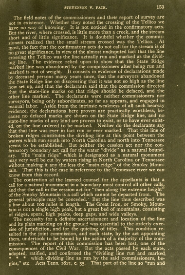
Federal court records: Stevenson et al. v. Fain et al.: Telico River area
GSMNP_13150_16_1133_07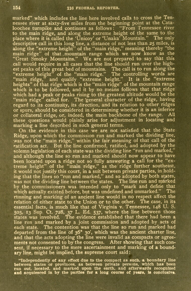
Federal court records: Stevenson et al. v. Fain et al.: Telico River area
GSMNP_13150_16_1133_08
Federal court records: Stevenson et al. v. Fain et al.: Telico River area
GSMNP_13150_16_1133_09
Federal court records: Stevenson et al. v. Fain et al.: Telico River area
GSMNP_13150_16_1133_10Item’s are ‘child’ level descriptions to ‘parent’ objects, (e.g. one page of a whole book).
-
-
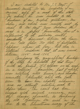
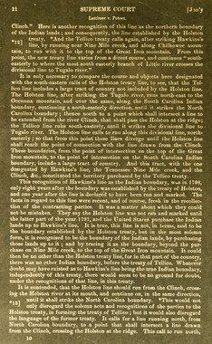
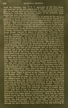
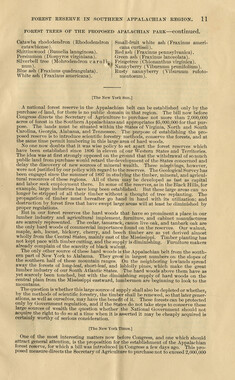
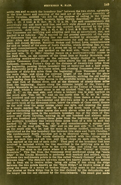
116 FEDERAL REPORTER. marked by the commission, such line must be accepted by the courts, in a suit between private persons, as the true and ancient boundary, even though it now appears that a different line between such points might more accurately conform to a general call in the act of cession for "the extreme height" of a certain mountain for a distance of 100 miles. 8. Same. In that part of the boundary line between North Carolina and Tennessee described in the confirmatory acts of the two states as running "from Tennessee river to the main ridge and along the extreme height of the same to the' place where it is called the 'Unicoy' or 'Unaka' Mountain," the boundary between the two known points called "County Corner" and "Gold Bryson Gap" follows the line run and marked by the joint commission along what is known as "State Ridge." Appeal from the Circuit Court of the United States for the Eastern District of Tennessee. This is a bill to remove a cloud upon the title to a body of wild mountain lands, including about 10,000 acres, lying adjacent to the boundary between Tennessee and North Carolina. The complainants claim title to the lands under grants from the state of Tennessee and mesne conveyances to them, and aver that they are in possession, and that said lands lie wholly in Monroe county, Tenn. They charge that the same lands are claimed by the defendants as heirs at law of one M. Fain, who claimed same under grants from the state of North Carolina. The object of the bill is to obtain the cancellation of these grants as a cloud upon complainants' title, and' for this purpose they aver that the lands so claimed and granted were not within the state of North Carolina, nor subject to grant by that state. The defendants disclaim title to any lands in Monroe county, Tenh., and aTer that the lands in controversy lie wholly within the county of Cherokee, state of North Carolina, and that they were lawfully granted to their ancestor by said state. The issue, therefore, involves the question of the true boundary between North Carolina and Tennessee, and the decree must be for the complainants if it shall appear that the.lands lie within the state of Tennessee. Tennessee originally constituted the western part of the state of North Carolina. The cession act of 1789, ceding the territory now constituting the state of Tennessee to the United States, describes the eastern boundary line as follows: "Beginning on the extreme height of the Stone Mountain, at the place where the A'ii-ginia line intersects it, running thence along the extreme height of the said mountain to the place' where the Wautauga river breaks through it; thence a direct course to the top of the Yellow Mountain, where Bright's road crosses same; thence along the ridge of said mountain, between the waters of Doe river and the waters of Rock creek, to the place where the road crosses the Iron Mountain; from thence along the extreme height of said mountain to where Nolinchucky river runs through the same; thence, to the top of the Bald Mountain; thence along the extreme height of the said mountain to the Painted Rock, on French Broad river; thence along the highest ridge of the said mountain to the place where it is called the 'Great Iron' or 'Smoky' Mountain; thence along the extreme height of the said mountain to the place where it is called 'Unicoy' or 'Unaka* Mountain, between the Indian towns Co wee. and Old Ch'ota; thence along the main ridge of the said mountain to the southern boundary of this state." -The line here to be ascertained is included within the call beginning: "Thence along the extreme height of the said mountain to the place where It is called 'Unicoy' or 'Unaka' Mountain, between the Indian towns Cowee and Old Chota." The ascertainment of the "main ridge" of the "Great Iron" .or "Smoky" Mountain, and the location of the boundary line along Its "extreme height," became at an early day a matter of importance to both states. To the end that the line thus indicated should -be settled, run, and marked, acts were passed in 1821 by both states, providing for a Joint commission to ascertain, run, and mark the line' of the cession act These acts were in substantially identical terms, and required the commissioners "to
Object’s are ‘parent’ level descriptions to ‘children’ items, (e.g. a book with pages).
-
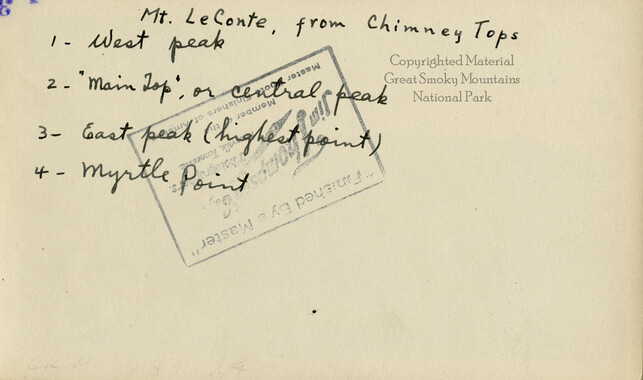
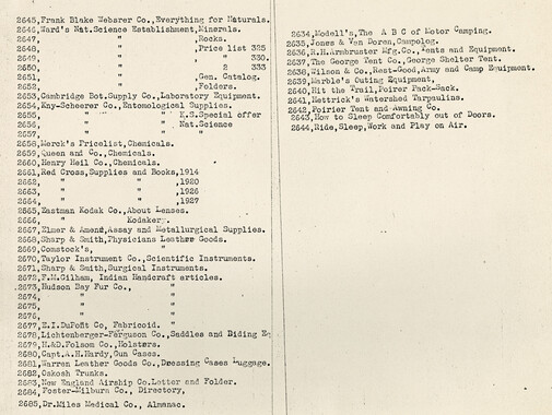
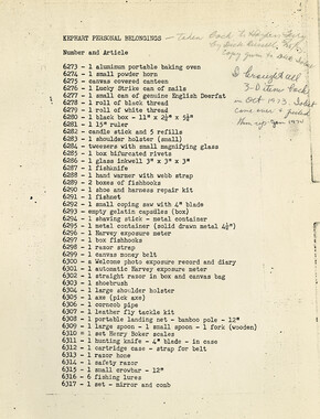
These copies of federal court records were collected by photographer, George Masa. Born Masahara Iizuka and raised in Japan, photographer George Masa (1881-1933) was active in the Appalachian Trail Club and in the movement to establish the Great Smoky Mountains National Park. In 1931, Masa was named to the three-person nomenclature committee for the North Carolina Park Commission and had the responsibility for accurately naming the peaks, streams, and other features. No doubt, these records pertain to the Smokies region and the disposition of land that would eventually become the Great Smoky Mountains National Park.
-


Part of Collection
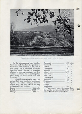
Great Smoky Mountains - A Park for America