- Canton Champion Fibre Company (2308)
- Cherokee Traditions (293)
- Civil War in Southern Appalachia (165)
- Craft Revival (1942)
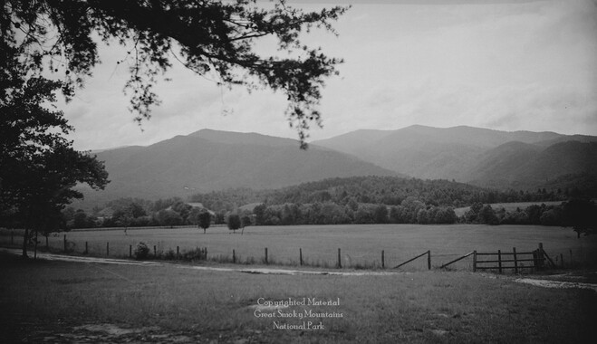
- Great Smoky Mountains - A Park for America (2767)
- Highlights from Western Carolina University (430)
- Horace Kephart (941)
- Journeys Through Jackson (154)
- LGBTQIA+ Archive of Jackson County (19)
- Oral Histories of Western North Carolina (314)
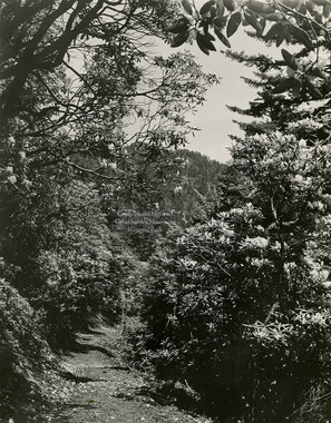
- Picturing Appalachia (6679)
- Stories of Mountain Folk (413)
- Travel Western North Carolina (160)
- Western Carolina University Fine Art Museum Vitreograph Collection (129)
- Western Carolina University Herbarium (92)
- Western Carolina University: Making Memories (708)
- Western Carolina University Publications (2283)
- Western Carolina University Restricted Electronic Theses and Dissertations (146)
- Western North Carolina Regional Maps (71)
- World War II in Southern Appalachia (131)
- Allanstand Cottage Industries (62)
- Appalachian National Park Association (53)
- Bennett, Kelly, 1890-1974 (1295)
- Berry, Walter (76)
- Brasstown Carvers (40)
- Carver, George Washington, 1864?-1943 (26)
- Cathey, Joseph, 1803-1874 (1)
- Champion Fibre Company (233)
- Champion Paper and Fibre Company (297)
- Cherokee Indian Fair Association (16)
- Cherokee Language Program (22)
- Crowe, Amanda (40)
- Edmonston, Thomas Benton, 1842-1907 (7)
- Ensley, A. L. (Abraham Lincoln), 1865-1948 (275)
- Fromer, Irving Rhodes, 1913-1994 (70)
- George Butz (BFS 1907) (46)
- Goodrich, Frances Louisa (120)
- Grant, George Alexander, 1891-1964 (96)
- Heard, Marian Gladys (60)
- Kephart, Calvin, 1883-1969 (15)
- Kephart, Horace, 1862-1931 (313)
- Kephart, Laura, 1862-1954 (39)
- Laney, Gideon Thomas, 1889-1976 (439)
- Masa, George, 1881-1933 (61)
- McElhinney, William Julian, 1896-1953 (44)
- Niggli, Josephina, 1910-1983 (10)
- North Carolina Park Commission (105)
- Osborne, Kezia Stradley (9)
- Owens, Samuel Robert, 1918-1995 (11)
- Penland Weavers and Potters (36)
- Roberts, Vivienne (15)
- Roth, Albert, 1890-1974 (142)
- Schenck, Carl Alwin, 1868-1955 (1)
- Sherrill's Photography Studio (2565)
- Southern Highland Handicraft Guild (127)
- Southern Highlanders, Inc. (71)
- Stalcup, Jesse Bryson (46)
- Stearns, I. K. (213)
- Thompson, James Edward, 1880-1976 (226)
- United States. Indian Arts and Crafts Board (130)
- USFS (683)
- Vance, Zebulon Baird, 1830-1894 (1)
- Weaver, Zebulon, 1872-1948 (58)
- Western Carolina College (230)
- Western Carolina Teachers College (282)
- Western Carolina University (1794)
- Western Carolina University. Mountain Heritage Center (18)
- Whitman, Walt, 1819-1892 (10)
- Wilburn, Hiram Coleman, 1880-1967 (73)
- Williams, Isadora (3)
- Cain, Doreyl Ammons (0)
- Crittenden, Lorraine (0)
- Rhodes, Judy (0)
- Smith, Edward Clark (0)
- Appalachian Region, Southern (2393)
- Asheville (N.C.) (1886)
- Avery County (N.C.) (26)
- Blount County (Tenn.) (161)
- Buncombe County (N.C.) (1664)
- Cherokee County (N.C.) (283)
- Clay County (N.C.) (555)
- Graham County (N.C.) (233)
- Great Smoky Mountains National Park (N.C. and Tenn.) (478)
- Haywood County (N.C.) (3522)
- Henderson County (N.C.) (70)
- Jackson County (N.C.) (4692)
- Knox County (Tenn.) (25)
- Knoxville (Tenn.) (12)
- Lake Santeetlah (N.C.) (10)
- Macon County (N.C.) (420)
- Madison County (N.C.) (211)
- McDowell County (N.C.) (39)
- Mitchell County (N.C.) (132)
- Polk County (N.C.) (35)
- Qualla Boundary (981)
- Rutherford County (N.C.) (76)
- Swain County (N.C.) (2020)
- Transylvania County (N.C.) (247)
- Watauga County (N.C.) (12)
- Waynesville (N.C.) (68)
- Yancey County (N.C.) (72)
- Aerial Photographs (3)
- Aerial Views (60)
- Albums (books) (4)
- Articles (1)
- Artifacts (object Genre) (228)
- Biography (general Genre) (2)
- Cards (information Artifacts) (38)
- Clippings (information Artifacts) (191)
- Crafts (art Genres) (622)
- Depictions (visual Works) (21)
- Design Drawings (1)
- Drawings (visual Works) (184)
- Envelopes (73)
- Facsimiles (reproductions) (1)
- Fiction (general Genre) (4)
- Financial Records (12)
- Fliers (printed Matter) (67)
- Glass Plate Negatives (381)
- Guidebooks (2)
- Internegatives (10)
- Interviews (811)
- Land Surveys (102)
- Letters (correspondence) (1013)
- Manuscripts (documents) (619)
- Maps (documents) (159)
- Memorandums (25)
- Minutes (administrative Records) (59)
- Negatives (photographs) (5735)
- Newsletters (1285)
- Newspapers (2)
- Occupation Currency (1)
- Paintings (visual Works) (1)
- Pen And Ink Drawings (1)
- Periodicals (193)
- Personal Narratives (7)
- Photographs (12982)
- Plans (maps) (1)
- Poetry (5)
- Portraits (1657)
- Postcards (329)
- Programs (documents) (151)
- Publications (documents) (2237)
- Questionnaires (65)
- Scrapbooks (282)
- Sheet Music (1)
- Slides (photographs) (402)
- Sound Recordings (796)
- Specimens (92)
- Speeches (documents) (15)
- Tintypes (photographs) (8)
- Transcripts (322)
- Video Recordings (physical Artifacts) (23)
- Vitreographs (129)
- Text Messages (0)
- A.L. Ensley Collection (275)
- Appalachian Industrial School Records (7)
- Appalachian National Park Association Records (336)
- Axley-Meroney Collection (2)
- Bayard Wootten Photograph Collection (20)
- Bethel Rural Community Organization Collection (7)
- Blumer Collection (5)
- C.W. Slagle Collection (20)
- Canton Area Historical Museum (2110)
- Carlos C. Campbell Collection (282)
- Cataloochee History Project (65)
- Cherokee Studies Collection (4)
- Daisy Dame Photograph Album (5)
- Daniel Boone VI Collection (1)
- Doris Ulmann Photograph Collection (112)
- Elizabeth H. Lasley Collection (1)
- Elizabeth Woolworth Szold Fleharty Collection (4)
- Frank Fry Collection (95)
- George Masa Collection (173)
- Gideon Laney Collection (452)
- Hazel Scarborough Collection (2)
- Hiram C. Wilburn Papers (28)
- Historic Photographs Collection (236)
- Horace Kephart Collection (861)
- Humbard Collection (33)
- Hunter and Weaver Families Collection (1)
- I. D. Blumenthal Collection (4)
- Isadora Williams Collection (4)
- Jesse Bryson Stalcup Collection (47)
- Jim Thompson Collection (224)
- John B. Battle Collection (7)
- John C. Campbell Folk School Records (80)
- John Parris Collection (6)
- Judaculla Rock project (2)
- Kelly Bennett Collection (1314)
- Love Family Papers (11)
- Major Wiley Parris Civil War Letters (3)
- Map Collection (12)
- McFee-Misemer Civil War Letters (34)
- Mountain Heritage Center Collection (4)
- Norburn - Robertson - Thomson Families Collection (44)
- Pauline Hood Collection (7)
- Pre-Guild Collection (2)
- Qualla Arts and Crafts Mutual Collection (12)
- R.A. Romanes Collection (681)
- Rosser H. Taylor Collection (1)
- Samuel Robert Owens Collection (94)
- Sara Madison Collection (144)
- Sherrill Studio Photo Collection (2558)
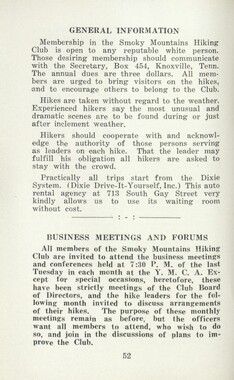
- Smoky Mountains Hiking Club Collection (616)
- Stories of Mountain Folk - Radio Programs (374)
- The Reporter, Western Carolina University (510)
- Venoy and Elizabeth Reed Collection (16)
- WCU Gender and Sexuality Oral History Project (32)
- WCU Mountain Heritage Center Oral Histories (25)
- WCU Oral History Collection - Mountain People, Mountain Lives (71)
- WCU Students Newspapers Collection (1744)
- Western North Carolina Tomorrow Black Oral History Project (69)
- William Williams Stringfield Collection (2)
- Zebulon Weaver Collection (109)
- African Americans (388)
- Appalachian Trail (35)
- Artisans (521)
- Cherokee art (84)
- Cherokee artists -- North Carolina (10)
- Cherokee language (21)
- Cherokee pottery (101)
- Cherokee women (208)
- Church buildings (166)
- Civilian Conservation Corps (U.S.) (110)
- College student newspapers and periodicals (1830)
- Dams (95)
- Dance (1023)
- Education (222)
- Floods (60)
- Folk music (1015)
- Forced removal, 1813-1903 (2)
- Forest conservation (220)
- Forests and forestry (917)
- Gender nonconformity (4)
- Great Smoky Mountains National Park (N.C. and Tenn.) (154)
- Hunting (38)
- Landscape photography (10)
- Logging (103)
- Maps (84)
- Mines and mineral resources (8)
- North Carolina -- Maps (18)
- Paper industry (38)
- Postcards (255)
- Pottery (135)
- Railroad trains (69)
- Rural electrification -- North Carolina, Western (3)
- School integration -- Southern States (2)
- Segregation -- North Carolina, Western (5)
- Slavery (5)
- Sports (452)
- Storytelling (245)
- Waterfalls -- Great Smoky Mountains (N.C. and Tenn.) (66)
- Weaving -- Appalachian Region, Southern (280)
- Wood-carving -- Appalachian Region, Southern (328)
- World War, 1939-1945 (173)
Federal court records: Latimer v. Poteet, Meigs Post
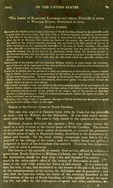
Federal court records: Latimer v. Poteet, Meigs Post
GSMNP_13150_15_1128_01
Federal court records: Latimer v. Poteet, Meigs Post
GSMNP_13150_15_1128_02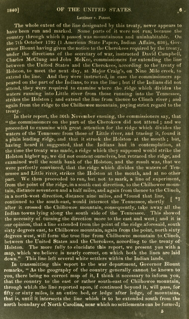
Federal court records: Latimer v. Poteet, Meigs Post
GSMNP_13150_15_1128_03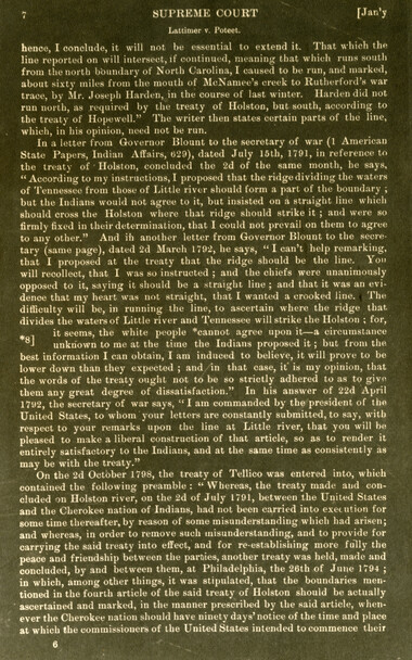
Federal court records: Latimer v. Poteet, Meigs Post
GSMNP_13150_15_1128_04
Federal court records: Latimer v. Poteet, Meigs Post
GSMNP_13150_15_1128_05
Federal court records: Latimer v. Poteet, Meigs Post
GSMNP_13150_15_1128_06
Federal court records: Latimer v. Poteet, Meigs Post
GSMNP_13150_15_1128_07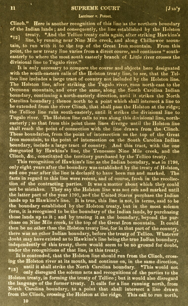
Federal court records: Latimer v. Poteet, Meigs Post
GSMNP_13150_15_1128_08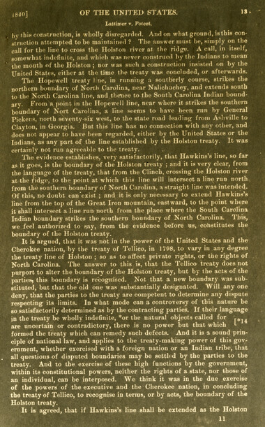
Federal court records: Latimer v. Poteet, Meigs Post
GSMNP_13150_15_1128_09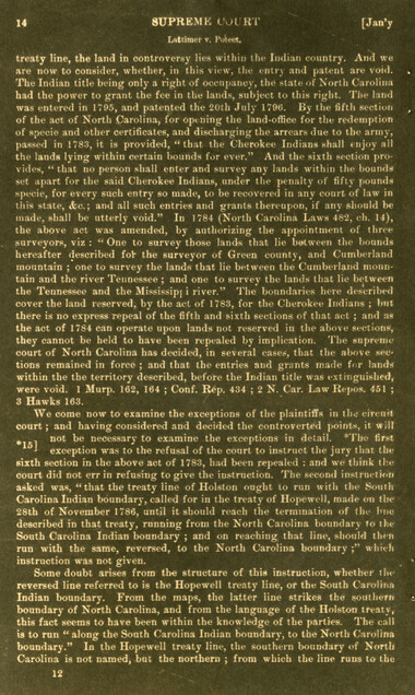
Federal court records: Latimer v. Poteet, Meigs Post
GSMNP_13150_15_1128_10
Federal court records: Latimer v. Poteet, Meigs Post
GSMNP_13150_15_1128_11
Federal court records: Latimer v. Poteet, Meigs Post
GSMNP_13150_15_1128_12
Federal court records: Latimer v. Poteet, Meigs Post
GSMNP_13150_15_1128_13Item’s are ‘child’ level descriptions to ‘parent’ objects, (e.g. one page of a whole book).
-
-
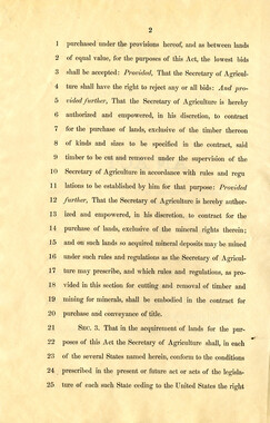
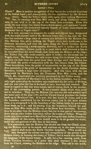
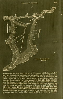
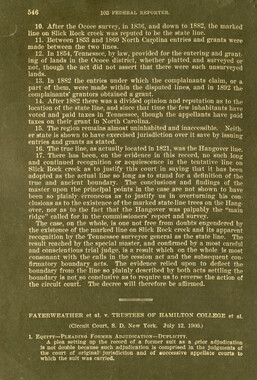
1 SUPREME COURT fJWy Lattimer <r. Poteet. Clinch." Here is another recognition of this line as the northern boundary of the Indian lands ; and consequently, the line established by the Holston * 1 treaty. *And the Tellico treaty calls again, after striking Hawkins's -• line, by running near Nine Mile creek, and along Chilhowee mountain, to run with it to the top of the Great Iron mountain. From this point, the new treaty line varies from a direct course, and continues " southeasterly to where the most south easterly branch of Little river crosses the divisional line to Tugalo river." It is only necessary to compare the course and objects here designated with the south-eastern calls of the Holston treaty line, to see, that the Tellico line ipoludes a large tract of country not included by the Holston line. The Holston line, after striking the Tugalo river, runs north-east to the Occunna mountain, and over the same, along the South Carolina Indian boundary, continuing a north-easterly direction, until it strikes the North Carolina boundary ; thence north to a point which shall intersect a line to be extended from the river Clinch, that shall pass the Holston at the ridge; the Tellico line runs south-easterly, until it strikes the divisional line to Tugalo river. The Holston line calls to run along this divisional line, northeasterly ; so that from this point these lines diverge until the Holston line shall reach the point of connection with the line drawn from the Clinch. These boundaries, from the point of intersection on the top of the Great Iron mountain, to the point of intersection on the South Carolina Indian boundary, include a large tract of country. And this tract, with the one designated by Hawkins's line, the Tennessee Nine Mile creek, and the Clinch, <fco, constituted the territory purchased by the Tellico treaty. This recognition of Hawkins's line as the Indian boundary, wus in 1798, only eight years after the boundary was established by the treaty of Holston, and one year after the line is declared to have been run and marked. The facts in regard to this line were recent, and of course, fresh in the recollection, of the contracting parties. It was a matter about which they could not be mistaken. They say the Holston line was not run and marked until the latter part of the year 1797, and the United Stares purchase the Indian lands up to Hawkins's line. It is true, this line is not, in terms, said to be the boundary established by the Holston treaty, but in the most solemn form, it is recognised to be the boundary of the Indian lands, by purchasing those lands up to it ; and by tracing it as the boundary, beyond the purchase on Nine Mile creek, to the top of the Great Iron mountain. It could then be no other than the Holston treaty line, for in that part of the country, there was no other Indian boundary, before the treaty of Tellico. Whatever doubt may have existed as to Hawkins's line being the true Indian boundary, independently of this treaty, there would seem to be no ground for doubt, under the recognitions of that line, in this treaty. It is contended, that the Holston line should run from the Clinch, crossing the Holston river at its mouth, and continue on, in the same direction, -, until it shall strike the North Carolina boundary. *This would not Holston treaty, in forming the treaty of Tellico ; but it would also disregard the language of the former treaty. It calls for a line running north, from North Carolina boundary, to a point that shall intersect a line drawn from the Clinch, crossing the Holston at the ridge. This call to run north,
Object’s are ‘parent’ level descriptions to ‘children’ items, (e.g. a book with pages).
-
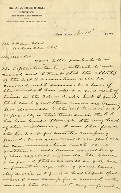
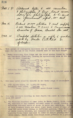
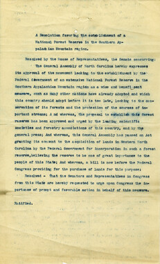
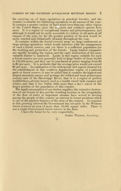
These copies of federal court records were collected by photographer, George Masa. Born Masahara Iizuka and raised in Japan, photographer George Masa (1881-1933) was active in the Appalachian Trail Club and in the movement to establish the Great Smoky Mountains National Park. In 1931, Masa was named to the three-person nomenclature committee for the North Carolina Park Commission and had the responsibility for accurately naming the peaks, streams, and other features. No doubt, these records pertain to the Smokies region and the disposition of land that would eventually become the Great Smoky Mountains National Park.
-


Part of Collection
Great Smoky Mountains - A Park for America