- Canton Champion Fibre Company (2308)
- Cherokee Traditions (293)
- Civil War in Southern Appalachia (165)
- Craft Revival (1942)
- Great Smoky Mountains - A Park for America (2767)
- Highlights from Western Carolina University (430)
- Horace Kephart (941)
- Journeys Through Jackson (154)
- LGBTQIA+ Archive of Jackson County (19)
- Oral Histories of Western North Carolina (314)
- Picturing Appalachia (6679)
- Stories of Mountain Folk (413)
- Travel Western North Carolina (160)
- Western Carolina University Fine Art Museum Vitreograph Collection (129)
- Western Carolina University Herbarium (92)
- Western Carolina University: Making Memories (708)
- Western Carolina University Publications (2283)
- Western Carolina University Restricted Electronic Theses and Dissertations (146)
- Western North Carolina Regional Maps (71)
- World War II in Southern Appalachia (131)
- Appalachian National Park Association (53)
- Berry, Walter (76)
- Champion Fibre Company (5)
- Fromer, Irving Rhodes, 1913-1994 (70)
- Grant, George Alexander, 1891-1964 (96)
- Kephart, Horace, 1862-1931 (23)
- Masa, George, 1881-1933 (17)
- North Carolina Park Commission (105)
- Roth, Albert, 1890-1974 (142)
- Schenck, Carl Alwin, 1868-1955 (1)
- Stearns, I. K. (2)
- Thompson, James Edward, 1880-1976 (45)
- Weaver, Zebulon, 1872-1948 (55)
- Wilburn, Hiram Coleman, 1880-1967 (72)
- Allanstand Cottage Industries (0)
- Bennett, Kelly, 1890-1974 (0)
- Brasstown Carvers (0)
- Cain, Doreyl Ammons (0)
- Carver, George Washington, 1864?-1943 (0)
- Cathey, Joseph, 1803-1874 (0)
- Champion Paper and Fibre Company (0)
- Cherokee Indian Fair Association (0)
- Cherokee Language Program (0)
- Crittenden, Lorraine (0)
- Crowe, Amanda (0)
- Edmonston, Thomas Benton, 1842-1907 (0)
- Ensley, A. L. (Abraham Lincoln), 1865-1948 (0)
- George Butz (BFS 1907) (0)
- Goodrich, Frances Louisa (0)
- Heard, Marian Gladys (0)
- Kephart, Calvin, 1883-1969 (0)
- Kephart, Laura, 1862-1954 (0)
- Laney, Gideon Thomas, 1889-1976 (0)
- McElhinney, William Julian, 1896-1953 (0)
- Niggli, Josephina, 1910-1983 (0)
- Osborne, Kezia Stradley (0)
- Owens, Samuel Robert, 1918-1995 (0)
- Penland Weavers and Potters (0)
- Rhodes, Judy (0)
- Roberts, Vivienne (0)
- Sherrill's Photography Studio (0)
- Smith, Edward Clark (0)
- Southern Highland Handicraft Guild (0)
- Southern Highlanders, Inc. (0)
- Stalcup, Jesse Bryson (0)
- United States. Indian Arts and Crafts Board (0)
- USFS (0)
- Vance, Zebulon Baird, 1830-1894 (0)
- Western Carolina College (0)
- Western Carolina Teachers College (0)
- Western Carolina University (0)
- Western Carolina University. Mountain Heritage Center (0)
- Whitman, Walt, 1819-1892 (0)
- Williams, Isadora (0)
- 1810s (1)
- 1840s (1)
- 1850s (2)
- 1860s (3)
- 1870s (4)
- 1880s (7)
- 1890s (64)
- 1900s (294)
- 1910s (227)
- 1920s (461)
- 1930s (1585)
- 1940s (82)
- 1950s (15)
- 1960s (13)
- 1970s (47)
- 1980s (14)
- 1990s (17)
- 2000s (31)
- 2010s (1)
- 1600s (0)
- 1700s (0)
- 1800s (0)
- 1820s (0)
- 1830s (0)
- 2020s (0)
- Appalachian Region, Southern (80)
- Asheville (N.C.) (1)
- Avery County (N.C.) (6)
- Blount County (Tenn.) (159)
- Buncombe County (N.C.) (204)
- Cherokee County (N.C.) (10)
- Clay County (N.C.) (3)
- Graham County (N.C.) (108)
- Great Smoky Mountains National Park (N.C. and Tenn.) (416)
- Haywood County (N.C.) (263)
- Henderson County (N.C.) (13)
- Jackson County (N.C.) (58)
- Knox County (Tenn.) (21)
- Knoxville (Tenn.) (11)
- Lake Santeetlah (N.C.) (10)
- Macon County (N.C.) (25)
- Madison County (N.C.) (14)
- McDowell County (N.C.) (5)
- Mitchell County (N.C.) (7)
- Polk County (N.C.) (2)
- Qualla Boundary (22)
- Rutherford County (N.C.) (16)
- Swain County (N.C.) (516)
- Transylvania County (N.C.) (36)
- Watauga County (N.C.) (2)
- Waynesville (N.C.) (2)
- Yancey County (N.C.) (34)
- Aerial Views (3)
- Articles (1)
- Artifacts (object Genre) (4)
- Clippings (information Artifacts) (77)
- Drawings (visual Works) (174)
- Envelopes (2)
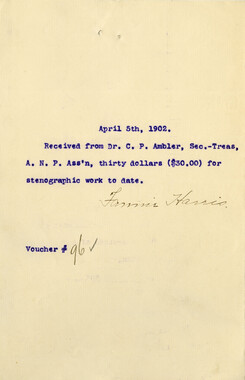
- Financial Records (9)
- Fliers (printed Matter) (34)
- Guidebooks (1)
- Interviews (11)
- Land Surveys (102)
- Letters (correspondence) (219)
- Manuscripts (documents) (91)
- Maps (documents) (69)
- Memorandums (14)
- Minutes (administrative Records) (20)
- Negatives (photographs) (282)
- Newsletters (12)
- Paintings (visual Works) (1)
- Pen And Ink Drawings (1)
- Photographs (1657)
- Portraits (39)
- Postcards (15)
- Publications (documents) (107)
- Scrapbooks (3)
- Sound Recordings (7)
- Speeches (documents) (11)
- Transcripts (46)
- Aerial Photographs (0)
- Albums (books) (0)
- Biography (general Genre) (0)
- Cards (information Artifacts) (0)
- Crafts (art Genres) (0)
- Depictions (visual Works) (0)
- Design Drawings (0)
- Facsimiles (reproductions) (0)
- Fiction (general Genre) (0)
- Glass Plate Negatives (0)
- Internegatives (0)
- Newspapers (0)
- Occupation Currency (0)
- Periodicals (0)
- Personal Narratives (0)
- Plans (maps) (0)
- Poetry (0)
- Programs (documents) (0)
- Questionnaires (0)
- Sheet Music (0)
- Slides (photographs) (0)
- Specimens (0)
- Text Messages (0)
- Tintypes (photographs) (0)
- Video Recordings (physical Artifacts) (0)
- Vitreographs (0)
- Appalachian National Park Association Records (336)
- Carlos C. Campbell Collection (282)
- Cataloochee History Project (65)
- George Masa Collection (89)
- Hiram C. Wilburn Papers (28)
- Historic Photographs Collection (236)
- Horace Kephart Collection (126)
- Humbard Collection (33)
- Jim Thompson Collection (44)
- Love Family Papers (11)
- Map Collection (12)
- R.A. Romanes Collection (10)
- Smoky Mountains Hiking Club Collection (616)
- Zebulon Weaver Collection (107)
- A.L. Ensley Collection (0)
- Appalachian Industrial School Records (0)
- Axley-Meroney Collection (0)
- Bayard Wootten Photograph Collection (0)
- Bethel Rural Community Organization Collection (0)
- Blumer Collection (0)
- C.W. Slagle Collection (0)
- Canton Area Historical Museum (0)
- Cherokee Studies Collection (0)
- Daisy Dame Photograph Album (0)
- Daniel Boone VI Collection (0)
- Doris Ulmann Photograph Collection (0)
- Elizabeth H. Lasley Collection (0)
- Elizabeth Woolworth Szold Fleharty Collection (0)
- Frank Fry Collection (0)
- Gideon Laney Collection (0)
- Hazel Scarborough Collection (0)
- Hunter and Weaver Families Collection (0)
- I. D. Blumenthal Collection (0)
- Isadora Williams Collection (0)
- Jesse Bryson Stalcup Collection (0)
- John B. Battle Collection (0)
- John C. Campbell Folk School Records (0)
- John Parris Collection (0)
- Judaculla Rock project (0)
- Kelly Bennett Collection (0)
- Major Wiley Parris Civil War Letters (0)
- McFee-Misemer Civil War Letters (0)
- Mountain Heritage Center Collection (0)
- Norburn - Robertson - Thomson Families Collection (0)
- Pauline Hood Collection (0)
- Pre-Guild Collection (0)
- Qualla Arts and Crafts Mutual Collection (0)
- Rosser H. Taylor Collection (0)
- Samuel Robert Owens Collection (0)
- Sara Madison Collection (0)
- Sherrill Studio Photo Collection (0)
- Stories of Mountain Folk - Radio Programs (0)
- The Reporter, Western Carolina University (0)
- Venoy and Elizabeth Reed Collection (0)
- WCU Gender and Sexuality Oral History Project (0)
- WCU Mountain Heritage Center Oral Histories (0)
- WCU Oral History Collection - Mountain People, Mountain Lives (0)
- WCU Students Newspapers Collection (0)
- Western North Carolina Tomorrow Black Oral History Project (0)
- William Williams Stringfield Collection (0)
- Appalachian Trail (22)
- Church buildings (9)
- Civilian Conservation Corps (U.S.) (91)
- Dams (21)
- Floods (1)
- Forest conservation (11)
- Forests and forestry (42)
- Great Smoky Mountains National Park (N.C. and Tenn.) (64)
- Hunting (2)
- Logging (25)
- Maps (74)
- North Carolina -- Maps (5)
- Postcards (15)
- Railroad trains (8)
- Sports (4)
- Storytelling (2)
- Waterfalls -- Great Smoky Mountains (N.C. and Tenn.) (39)
- African Americans (0)
- Artisans (0)
- Cherokee art (0)
- Cherokee artists -- North Carolina (0)
- Cherokee language (0)
- Cherokee pottery (0)
- Cherokee women (0)
- College student newspapers and periodicals (0)
- Dance (0)
- Education (0)
- Folk music (0)
- Forced removal, 1813-1903 (0)
- Gender nonconformity (0)
- Landscape photography (0)
- Mines and mineral resources (0)
- Paper industry (0)
- Pottery (0)
- Rural electrification -- North Carolina, Western (0)
- School integration -- Southern States (0)
- Segregation -- North Carolina, Western (0)
- Slavery (0)
- Weaving -- Appalachian Region, Southern (0)
- Wood-carving -- Appalachian Region, Southern (0)
- World War, 1939-1945 (0)
- Sound (7)
- StillImage (2172)
- Text (655)
- MovingImage (0)
Cataloochee tract 244: John M. Palmer

Cataloochee tract 244: John M. Palmer
GSMNP_80235
Cataloochee tract 244: John M. Palmer
GSMNP_02120_III-B-10482_a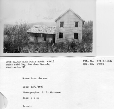
Cataloochee tract 244: John M. Palmer
GSMNP_02120_III-B-10482_b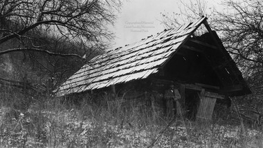
Cataloochee tract 244: John M. Palmer
GSMNP_02120_III-B-10483_a
Cataloochee tract 244: John M. Palmer
GSMNP_02120_III-B-10483_b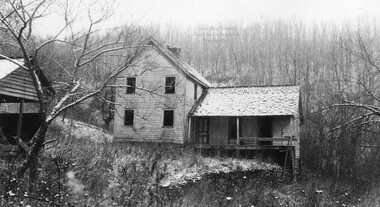
Cataloochee tract 244: John M. Palmer
GSMNP_02120_III-B-10484_a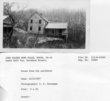
Cataloochee tract 244: John M. Palmer
GSMNP_02120_III-B-10484_b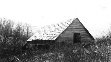
Cataloochee tract 244: John M. Palmer
GSMNP_02120_III-B-10485_a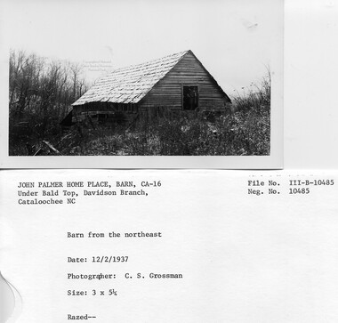
Cataloochee tract 244: John M. Palmer
GSMNP_02120_III-B-10485_b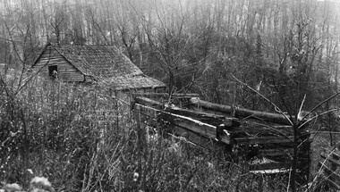
Cataloochee tract 244: John M. Palmer
GSMNP_02120_III-B-10486_a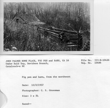
Cataloochee tract 244: John M. Palmer
GSMNP_02120_III-B-10486_b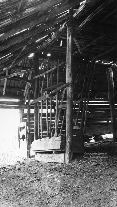
Cataloochee tract 244: John M. Palmer
GSMNP_02120_III-B-10487_a
Cataloochee tract 244: John M. Palmer
GSMNP_02120_III-B-10487_b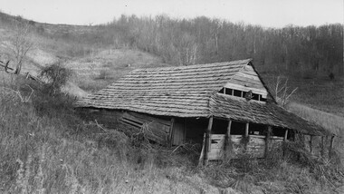
Cataloochee tract 244: John M. Palmer
GSMNP_02120_III-B-9861_a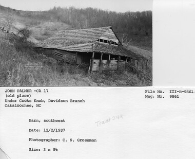
Cataloochee tract 244: John M. Palmer
GSMNP_02120_III-B-9861_02Item’s are ‘child’ level descriptions to ‘parent’ objects, (e.g. one page of a whole book).
-
-
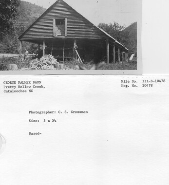
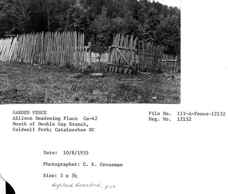
CATALOOCHEE HISTORIC DISTRICT: CULTURAL LANDSCAPE REPORT GREAT SMOKY MOUNTAINS NATIONAL PARK January 2000 Dianne L. Flaugh Historical Landscape Architect Cultural Resources Resource Management Great Smoky Mountains National Park National Park Service I I I~ I I I I I I r I I I I I I I I CHAPTER 4: INDIVIDUAL TRACTS 149 John Palmer Tract (244) Location This 171.14-acre tract is found along Little Cataloochee trail west of Davidson Gap. History Various members of the Palmer family purchased the five parcels that make up this tract. The first fifty acre parcel was bonded to Polly Palmer, wife of George Palmer, from the Love holdings in 1858. Jesse Palmer obtained control ofthe parcel and in 1883, transferred ownership to his brother George (Fayt) Palmer. In 1888, Fayt transferred ownership of this tract to his son, George H. Palmer (Creek George). Three more tracts of eighteen, twenty-six, and twenty-two acres ofland were bonded to Fayt Palmer in 1892, and in 1894, transferred to Creek George Palmer. All four of these tracts were transferred from Creek George Palmer to }liram and John Palmer in 1920 with John acquiring sole ownership in 1923. A fmal fifty acre tract was bonded to Fayt Palmer in 1881, from the Love holdings. This tract was transferred to his son, John Palmer in 1901. The NCPC acquired the total acreage from John Palmer in 1930, for $7,210. Fayt Palmer had extensive land holdings in Cataloochee and it is impossible to determine from the available records what activities were occurring where. In 1880, he recorded ownership of over six hundred acres of land of which sixty acres were tilled and twelve were permanent pasture. It is possible that a portion of this cleared land and pastureland was found on this tract. Creek George Palmer and his wife, Martha Russell, were farmers who raised cattle, sheeJ?, hogs and chickens. He also had an extensive apple orchard that included Buff, Milan, June Transparent, and Sheepsnose apples. Harvested apples were shipped to Waynesville. In 1916, Palmer moved his family out of Cataloochee. 1 When John Palmer acquired the Creek George Palmer property he moved from his farmstead, located nearer to Cooks Knob, to the Creek George Palmer farmstead, which was located closer to Davidson Gap. Vegetation NCPC records for tract 244 indicate that it consisted of seventy acres of cultivated land and one hundred and one acres of woodland. It is known that Creek George Palmer had an extensive orchard. It is likely that John Palmer also had an orchard on his original fifty acre tract located closer to Cooks Knob.2 The exact locations of these orchards remain unknown. Circulation A wagon road extended up Palmer Creek and Davidson Branch to provide access to both the John Palmer homesite near Cooks Knob and the Creek George Palmer homesite near Davidson Gap. A trail extends up through Davidson Gap to descend into Little Cataloochee and reach the Upper Place of Will Messer. 150 C ULTURAL LANDSCAPE REPORT: C ATALOOCHEE Hlsm RIC DISTRICT Structures, Furnishings, and Objects NCPC records for tract 244 indicates that it contained two farmsteads. That located near Davidson Gap consisted of a six-room frame house, barn, springhouse, smokehouse, and applehouse. The farmstead nearest Cooks Knob included a five-room frame house, log barn, and log applehouse. At Davidson Gap, the two-story frame house was situated north of the road and had with a one-story ell extending toward the road. Both the east and west sides of the ell had porches. A rock embankment wall ran in line with the south wall of the ell (figure 56). The frame springhouse and smokehouse were found north ofthehouse. Figure 56. John Palmer House, 1937. Note rock embankment. GRSM Archives. Both the applehouse and barn are described in building survey notes. The log apple house stood along the road east of the house and measured 20' by 16'. It was constructed of slightly hewn, pine logs with notched corners. Mud and stones chinked the logs. The barn measured 36' by 46' and stood west of the house. It had two pens, standing twelve logs high. These were constructed of chestnut and the chinks were partially filled with split rails. The homesite nearest Cooks Knob was described as the Old John Palmer Place in the building survey notes. A Grossman sketch shows that the applehouse and barn were both located north ofthe house. Except for a photograph of the barn that depicts open fields extending to the ridgetop, no other documentation has been found. Existing Conditions This area is within subzone Natural Environment-Type I, which emphasizes the natural environment. This area was not included in the vegetation survey of Cataloochee conducted in 1997. Site visits show that the area of the homesite is forested with tulip poplar and has an open understory. This is typical to other areas of former agricultural land undergoing reforestation. It is likely that other formerly cleared areas of this tract have a similar I I I I I I I I I I I I I • ~ 1 I I I~ I I I I I I r- ~ ~ " I I I I I I I ~ I CHAPTER 4: lNDNIDUAL TRACTS Figure 57. Log remnants of applehouse, 1999. forest cover. Ornamentals including yucca and daffodils were found in the area of the homesite. Little Cataloochee trail now extends past this site to reach Davidson Gap before descending into Little Cataloochee. It is open to both foot and horse travel. No NPS maintained trail leads to the Cooks Knob homesite. 151 The homesite area along Davidson Gap trail remains evident. A stone embankment wall and the log remnants of the applehouse that was built into the slope mark the homesite location (figure 57). A concrete trough was found in the general area of the barnsite although no other trace of the bam was noted. A defunct NPS animal trap stands above the stone embankment wall. Several short stone walls are found upslope from the 152 CULTIJRAL LANDSCAPE REPORT: C ATALOOCHEE HISTORIC DISTRICT homesite and east along Little Cataloochee Trail. These appear to have been built for erosion or water control. No current information is available for the Cooks Knob homesite. Analysis and Evaluation This site is associated with early settlement and the Palmer family. It also is connected with the commercial apple industry and circulation patterns between Big Cataloochee and Little Cataloochee communities . . Reforestation, loss of orchards, and the removal of buildings have impacted the site. However, the reforested agricultural land remains evident, dominated by pioneer tree species. While no buildings remain standing, there are small scale landscape elements and remnants that illustrate the history and use of the site. These include structural elements such as walls, fences, and timber remnants of the applehouse. Historic circulation patterns through the site remain evident. The mountainous setting and remaining landscape elements attest to the difficult nature of subsistence farming in Cataloochee. NOTES 1 Ethel Palmer McCracken, Interview by Jacqueline Lott and author, Written notes, Waynesville, NC, 12 January 1998. 2 Building lists indicate that he had an applehouse on the upper property. 3 Charles Grossman, Grossman notebooks, B-4, 1935, GRSM Archives. I I I I I I I I I I I I
Object’s are ‘parent’ level descriptions to ‘children’ items, (e.g. a book with pages).
-
This 171-acre tract 244 in Cataloochee was owned by John M. Palmer. While, in general, the Great Smoky Mountains region was sparsely populated, the Cataloochee Valley remained an exception. By 1900, the population of Cataloochee had grown to 1,000 residents living in hundreds of log and frame homes. A few historic buildings have been preserved on site, including two churches, a school, several homes, and outbuildings. The North Carolina Park Commission was tasked with purchasing land for the Great Smoky Mountains National Park and people living in Cataloochee were among those displaced. Cataloochee families continue to return for annual reunions. In 2001, the National Park Service re-introduced elk into the valley.
-


Part of Collection
Great Smoky Mountains - A Park for America